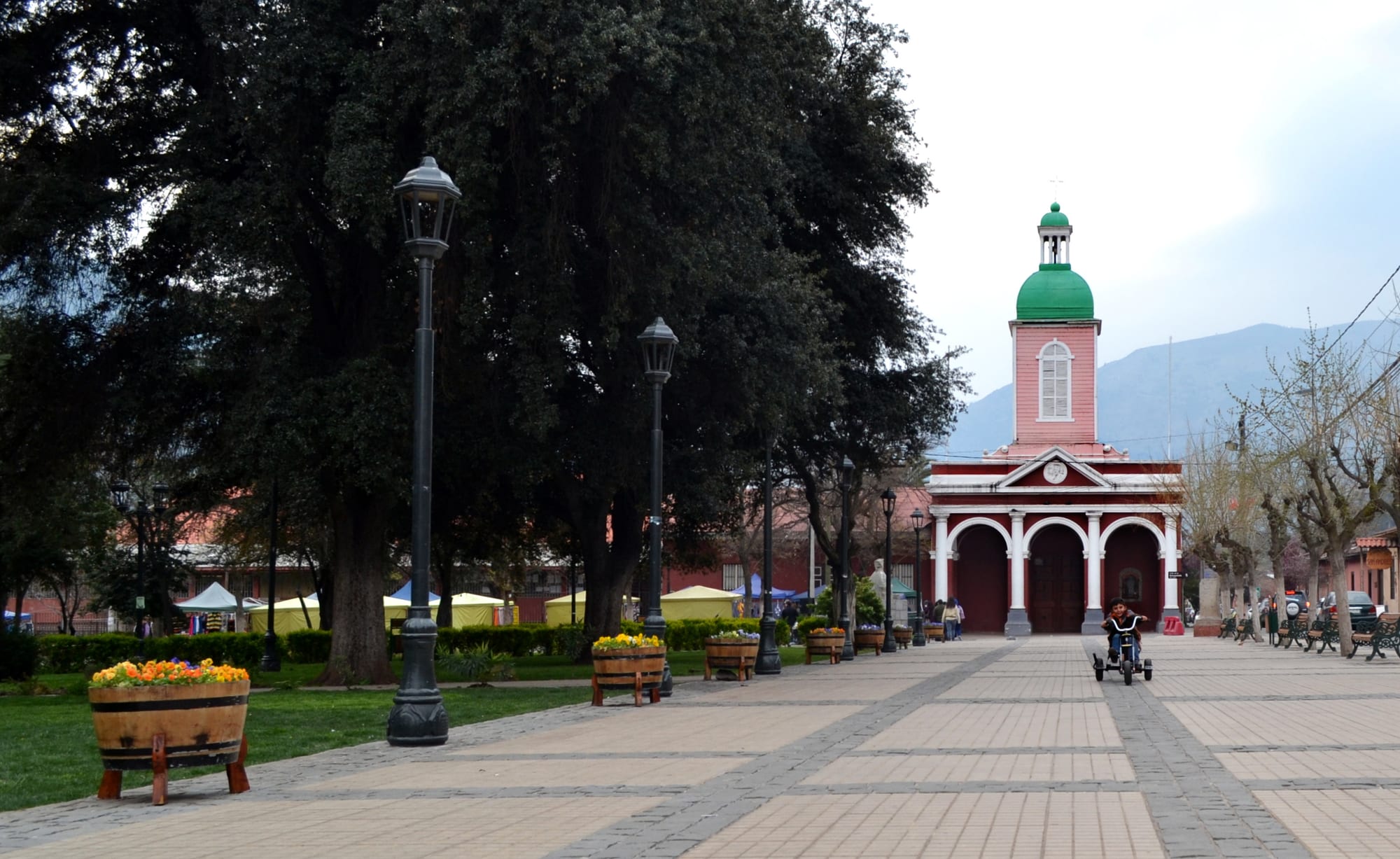
A paved plaza with tall trees and black lamp posts leading to a pink church with a green-domed bell tower, with mountains behind

Santiago & Valparaíso, Chile

San José de Maipo

The Plaza de Armas and the parish church of San José de Maipo, a national monument. (Angel Labra Castillo / Wikimedia Commons · CC BY-SA 3.0)

The main village of the Cajón del Maipo, the canyon of the upper Maipo river about 48 kilometres south-east of Santiago. Founded in 1792 to serve the mines of the valley, it later became a place of hydroelectric plants and tuberculosis sanatoriums; today its colonial centre is a base for rafting, hiking, hot springs and the reservoir and glacier high in the Andes.

Neighbourhoods

  • The historic centre
    • First-time visitors
    • Historic district

    The colonial core around the Plaza de Armas, declared a national monument, with the parish church facing the square and the old Laennec sanatorium opposite. It is the commune's main urban centre, beside the Maipo river at about 970 metres above sea level.

    Open in Maps
  • The villages of the Camino al Volcán
    • Nature
    • Outdoor activities

    Route G-25, the Camino al Volcán, climbs the canyon past small settlements such as El Melocotón towards El Volcán, following the line of the old military railway. Riverside lodgings, campsites and rafting bases are scattered along the road.

    Open in Maps
  • Baños Morales and the upper valley
    • Hiking
    • Hot springs

    A hamlet of about forty residents at roughly 1,800 metres, where the Morales and Volcán rivers meet, around 87 kilometres by road from Santiago. Its hot springs and the entrance to El Morado make it the starting point for the high Andes.

    Open in Maps

Things to do

In the village

  • Church of San José de Maipolandmark

    The parish church on the Plaza de Armas, built on the plot set aside for it when the town was founded in 1792, and declared a national monument together with its parish house in 1992.

    Open in Maps
  • Former Laennec Sanatoriumlandmark

    A former hotel for lung patients opened in the 1890s by the Frenchman Emilio Goujon Fournier, who found the mountain climate similar to the Alps', later run as the Laennec sanatorium; its two buildings face the Plaza de Armas and are a national monument.

    Open in Maps

Short trips into the Andes

  • Cajón del Maipoattraction

    The narrow Andean canyon of the upper Maipo, popular with hikers and campers, whose river's suitability for white-water rafting helped tourism grow from the late 20th century.

    Open in Maps
  • El Yeso reservoirviewpoint

    A turquoise reservoir completed in 1964 high in the Andes, which with the nearby Laguna Negra is a major source of Santiago's drinking water.

    Open in Maps
  • El Morado Natural Monumentpark

    A protected glacial cirque below Cerro El Morado, entered from Baños Morales and walked to the San Francisco glacier; it draws many Chilean and foreign visitors every year.

    Open in Maps
  • Baños Morales hot springsattraction

    Thermal springs at the meeting of the Morales and Volcán rivers, the main attraction of the hamlet of the same name.

    Open in Maps
  • Pirqueattraction

    The neighbouring commune at the mouth of the canyon, home to the Concha y Toro winery, the largest wine producer in Latin America.

    Open in Maps

Eat and drink

Long-standing places and food districts in San José de Maipo. Hours, ratings and directions come from your maps app, always current.

Food in the valley

  • Restaurants around the Plaza de Armasneighborhood

    The commune has a great number of places to eat and stay, and the streets around the plaza serve Chilean country cooking to day visitors from Santiago.

    Open in Maps
  • Restaurants on the Camino al Volcánneighborhood

    Roadside restaurants and lodges along the canyon road above the town.

    Open in Maps

Experience San José de Maipo

History

The upper Maipo valley was a mining area in colonial times, and on 16 July 1792 the governor Ambrosio O'Higgins founded the Villa de San José de Maipo to support the mines around San Pedro Nolasco. A plot facing the new plaza was set aside for the church and the priest, and Catholic services began the following year. During the wars of independence the valley's passes into Argentina made it a military route: a column of the Army of the Andes under Captain José León Lemos came over the Portillo pass to distract the royalist forces of Marcó del Pont while the main army crossed further north.

Larger-scale mining began at the end of the 19th century, and in the 20th the valley became part of Santiago's infrastructure. The first hydroelectric plant of the area was built at Los Maitenes, an aqueduct began carrying water from the Andean glaciers to the capital, and a narrow-gauge military railway was built from Puente Alto to El Volcán, opening in sections between 1910 and 1914; a tunnel and bridges from the line can still be seen. The pure, dry mountain air drew sanatoriums for patients with lung disease, above all tuberculosis, from all over Chile, among them the Laennec, which began in the 1890s as a hotel for lung patients opened by the Frenchman Emilio Goujon Fournier.

From the late 20th century the canyon turned to tourism, helped by a river well suited to rafting. In 2001 the commune was declared a Zone of National Tourist Interest, and the old centre of the village is protected as a national monument.

Culture & Customs

San José de Maipo keeps the look of a colonial village. Its parish church and parish house, on the corner of the plaza, were declared a national monument in 1992, the historic centre around them is protected, and the two buildings of the old Laennec sanatorium, also a national monument, stand opposite. The village is the administrative centre of the most thinly populated commune of the Santiago Metropolitan Region, a territory that runs east to the Argentine border.

Its culture is that of a mountain community living between farming, mining and visitors. Craftspeople work the local laja stone and alabaster, almonds and stone fruits are local produce, and a neighbourhood football league brings together around a dozen clubs from across the Cajón. Local radio stations broadcast to the valley, and the old railway, the sanatorium years and the independence column over the Andes are part of how the commune tells its own story.

For Santiago, the Cajón del Maipo is the nearest escape into the Andes: campers, rafters and hikers head up the valley for the river, the reservoir and the glacier, and the village is where they stop for supplies and a meal on the way.

Daily Life

About 18,000 people lived in the commune at the 2017 census, around 70 per cent of them in urban areas, chiefly the village of San José de Maipo itself; the rest live in small settlements strung along the canyon road and its side valleys. Spread over almost 5,000 square kilometres, it is the most thinly populated commune in the region.

The economy mixes non-metallic mining and stone quarrying, crafts and local produce with hydroelectric power — the Los Queltehues, Los Maitenes and Alfalfal plants all draw on the valley's rivers. Tourism has grown into one of the main sources of work, and the commune has a large number of restaurants and lodgings for visitors. The valley's water matters to the whole capital: the El Yeso reservoir and the Laguna Negra are major sources of Santiago's drinking water.

Life follows the seasons: quiet in winter, busy in spring and summer, when visitors from the capital come up the canyon road. Roberto Pérez of the Radical Party is the mayor.

Food

The valley eats the country cooking of central Chile. Empanadas de pino, baked turnovers of minced beef, onion, egg and olive, are the standard roadside meal, along with cazuela, a clear stew with a piece of meat, potato and pumpkin, and, in summer, pastel de choclo, a pie of sweet ground corn over a meat filling. Sopaipillas, fried pastries made with squash, are a street snack, and grilled meat is the centre of weekend gatherings.

Local produce is part of the appeal: almonds and stone fruits from the valley's orchards are local produce, and the vineyards of the Maipo valley, famous for Cabernet Sauvignon, begin just below the canyon at Pirque. Most restaurants are around the village centre or along the Camino al Volcán, many serving lunch, the main meal of the day, to visitors from Santiago. Mote con huesillo, a sweet cold drink of dried peaches in syrup with husked wheat, is a summer refreshment across central Chile, and a glass of pisco sour or local wine usually comes with the meal.

Planning tools

Budget

Day trips from Santiago are cheap if made by public transport, but most of the valley's attractions — rafting, guided hikes, the hot springs and the high reservoir — cost more because they need a tour or a hire car. Lodging is mostly cabins, guesthouses and campsites, and prices rise at weekends and in summer when Santiago empties into the mountains.

Daily Budget Midrange
USD 100–200 (cabin or lodge, rafting or a guided hike, hot springs, a hire car)
Daily Budget Shoestring
USD 40–70 (campsite or hostel, set-menu lunches, buses up the valley)

Visit on a weekday to avoid the weekend traffic from Santiago, and carry cash for the smaller places up the valley.

Best Time to Visit

Spring and summer, from October to March, are the season for rafting, hiking and the high reservoir. Autumn brings colour to the valley. In winter snow closes or restricts the higher roads and trails, though the village itself stays reachable.

Suggested Number of Days

Many people come for a single day from Santiago. A night or two in the valley makes room for the high country and an early start on the mountain roads; three or four days suit hikers and anyone wanting the upper valley at an easy pace.

First Visit
1–2 days
With Surroundings
3–4 days

Transportation

One road, Route G-25, the Camino al Volcán, runs up the canyon from Puente Alto through San José de Maipo towards El Volcán, and everything in the valley lies along it or up its side roads. The upper valley is easiest by tour or hire car, and the higher roads can be affected by snow in winter.

Fill the tank before leaving the village and check road conditions before driving to the reservoir or Baños Morales.

Airport & Station Connections

The village is 48 kilometres from Santiago by road, reached through Puente Alto on the city's south-eastern edge. Santiago's Arturo Merino Benítez International Airport, in Pudahuel, 15 kilometres north-west of the city centre, is the nearest. Many visitors come on organised tours, and the region's wine valleys and the Cajón del Maipo are easiest by tour or hire car.

Walkability

The historic centre is small and easy to walk, with the church, the plaza and the old sanatorium together. Beyond it, the canyon road has no pavements for long stretches and traffic can be fast, so the attractions up the valley need transport.

Safety

Chile is one of the safer countries in South America, but petty and opportunistic crime has risen, especially in Santiago and Valparaíso — pickpocketing, bag-snatching, phone theft, and distraction scams in tourist areas, markets, and on transport. The village itself is calm; the real risks are natural: a fast, cold river, steep mountain roads, altitude and sudden weather in the high Andes, and snow in winter.

Raft only with established operators, carry water and warm layers for hikes above the village, and tell someone the route before walking in the high mountains. Check current official travel advice before travelling.

Climate

The village has a Mediterranean mountain climate, cooler than Santiago because of its height, with dry summers and wetter winters; the commune rises into tundra and glacier climates high in the Andes. Summer runs from December to February.

Summer
dry and sunny, a little cooler than Santiago, where days often pass 30°C, and much colder at the reservoir and glacier
Winter
cool and damp, with nights at least as cold as Santiago's, which fall to around 0°C, and snow in the high valley

Local Customs

A tip of about 10 per cent is expected in restaurants when service has been satisfactory. The valley is rural and informal, and many families have lived here for generations; dress for the outdoors is normal everywhere. Crafts made from local laja stone and alabaster are sold in the commune.

Take litter home from the mountains, keep to marked paths in the protected area, and close gates on farm land.

Common Payment Methods

The currency is the Chilean peso (CLP). Cards are accepted in most restaurants and lodgings in the village, but small shops, stalls and places up the valley may want cash, so it is best to withdraw money before heading into the mountains. ATMs charge fees.