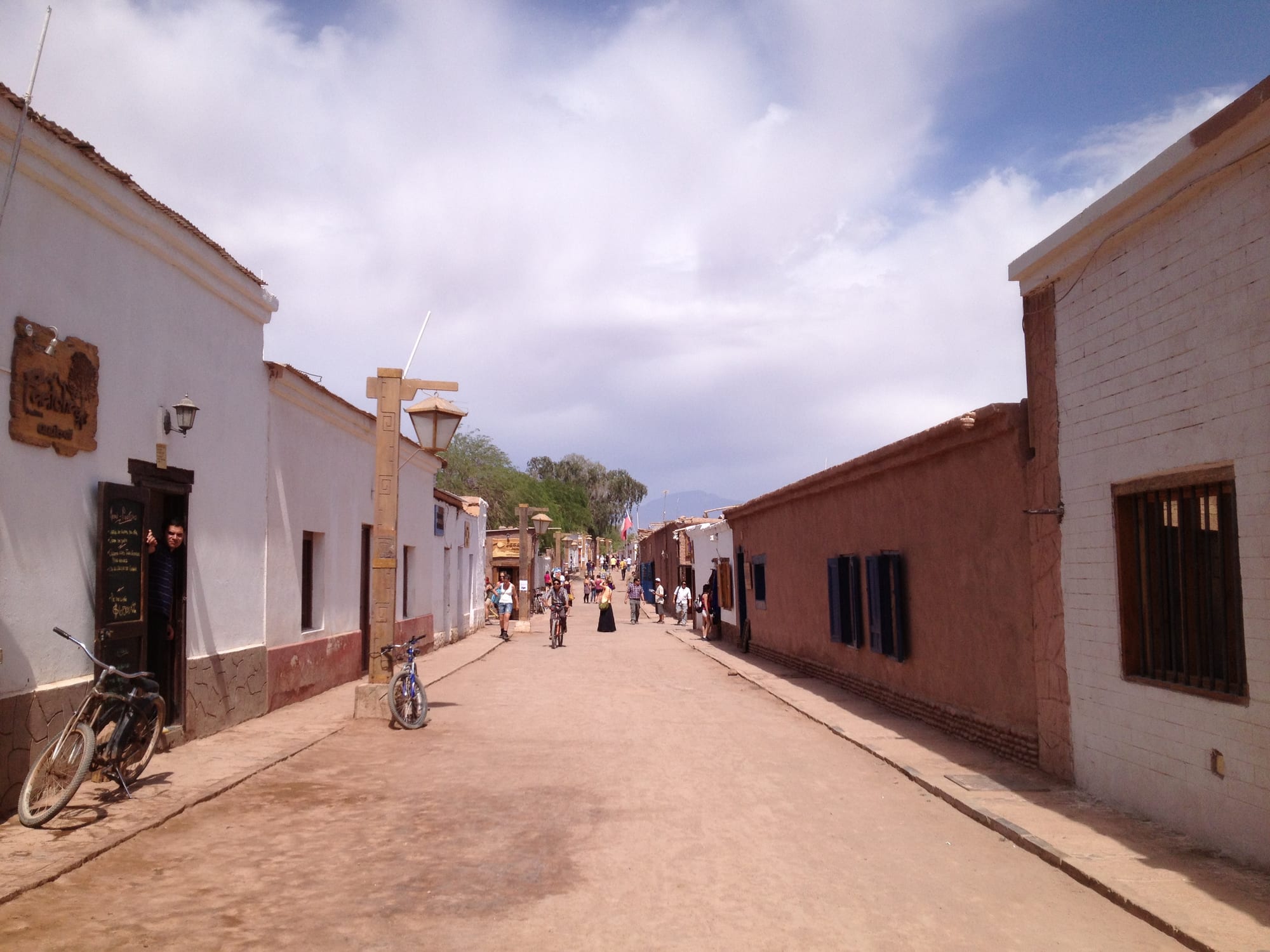
A dusty unpaved street lined with low whitewashed and ochre adobe buildings, with walkers and cyclists under a cloudy blue sky

San Pedro de Atacama & the North, Chile

San Pedro de Atacama

Calle Caracoles, the pedestrian main street of San Pedro de Atacama. (Paulo JC Nogueira / Wikimedia Commons · CC BY-SA 3.0)

An adobe oasis town at about 2,400 metres north of the Salar de Atacama, beneath the Licancabur volcano. The Atacameño people farmed here for thousands of years; Bolivian until the War of the Pacific, it has become one of Chile's most visited places, the base for the desert's valleys, geysers, salt lagoons and night skies.

Neighbourhoods

  • The town centre and Calle Caracoles
    • First-time visitors
    • Restaurants
    • Tour agencies

    A dozen small blocks of adobe walls and dirt streets around the Plaza de Armas, the church and the archaeological museum. Caracoles, the pedestrian main street, holds most of the restaurants, bars, shops and the many agencies selling tours.

    Open in Maps
  • The ayllus
    • Quiet and residential
    • Countryside

    The farming hamlets of the oasis spread around the town, with fields, orchards and adobe houses, guesthouses and some of the larger hotels. They are a walk or bicycle ride from the centre and much quieter at night.

    Open in Maps

Things to do

In the town

  • Church of San Pedro de Atacamalandmark

    A 17th-century adobe church on the main square, reportedly the second oldest in Chile and a National Monument, simple and white outside.

    Open in Maps
  • Gustavo Le Paige Archaeological Museummuseum

    The museum founded by the Belgian Jesuit priest Gustavo Le Paige, with ceramics, basketry and other finds from the oasis's first peoples; it reopened in late 2016 after a redevelopment.

    Open in Maps

Around the oasis

  • Pukará de Quitorlandmark

    A pre-Columbian stone fortress on a hillside 3 kilometres north-west of town, overlooking the San Pedro river valley, built in the 12th century and a National Monument since 1982.

    Open in Maps
  • Tulorlandmark

    The excavated remains of an ancient village of round clay-walled buildings in the desert near the town, first settled between about 380 BC and AD 200.

    Open in Maps
  • Valle de la Lunaviewpoint

    A valley in the Cordillera de la Sal 13 kilometres west of town, with stone and sand formations carved by wind and water, salt outcrops and caves, part of the Los Flamencos National Reserve and busiest at sunset.

    Open in Maps
  • Puritama Hot Springsattraction

    Eight large pools of geothermal water along a canyon about 30 kilometres north-east of town, at nearly 3,500 metres.

    Open in Maps

Short trips into the desert

  • El Tatioattraction

    A geyser field at 4,320 metres, the third largest in the world and the largest in the Southern Hemisphere, visited at dawn, when the steam columns are most visible.

    Open in Maps
  • Laguna Chaxa and Los Flamencos National Reservepark

    The reserve's sections include the flamingo lagoon of Chaxa in the Salar de Atacama, Chile's largest salt flat, and the altiplanic lagoons of Miscanti and Miñiques at about 4,200 metres.

    Open in Maps
  • Licancaburviewpoint

    The almost perfect cone of a 5,916-metre volcano on the Bolivian border, which dominates the view east of town and holds a crater lake and Inca or Atacameño ceremonial sites near its summit.

    Open in Maps

Seasonal events

  • Virgen de la Candelaria2 February

    A feast with traditional dances, street masses and a small parade along the main street.

  • San Pedro and San Pablolate June

    The patron-saint festival of the town, on 28 and 29 June, with traditional dances, masses in the street and a parade.

Eat and drink

Long-standing places and food districts in San Pedro de Atacama. Hours, ratings and directions come from your maps app, always current.

San Pedro classics

  • Restaurants on Calle Caracolesneighborhood

    Most of the town's restaurants and bars line the pedestrian main street, serving dishes from central Chile, Andean food and international menus for visitors.

    Open in Maps
  • Llama anticuchosrestaurant

    Skewers of grilled llama meat, sold by local people at Machuca, a stop on the way back from El Tatio.

    Open in Maps

Experience San Pedro de Atacama

History

People have lived around the oases of the Salar de Atacama for thousands of years. The Atacameños, who call themselves Lickanantay, domesticated llamas, farmed the oasis and settled in villages such as Tulor, and they developed the basketry and pottery still sold in the town. How closely they were tied to the Tiwanaku culture is debated; in the 12th century they built the fortress of Pukará de Quitor above the river, and the area later came under Inca rule.

Less than a century after the Incas, the Spanish arrived, and fighting with the Atacameño communities lasted until a settlement in 1557. Colonial rule brought forced resettlement, conversion to Catholicism and the decline of the Kunza language, and the adobe church was built in the 17th century. After independence San Pedro belonged to Bolivia; it lost its role as regional capital to the port of Cobija in 1829, and Bolivia promoted alfalfa growing here to feed the mule trains between the altiplano and the coast. Chile took the area in the War of the Pacific, and the Battle of Río Grande was fought nearby.

In the 20th century the mining boom drew many people to Calama and Chuquicamata. From the late 1950s the Belgian Jesuit priest Gustavo Le Paige, the town's parish priest, carried out extensive archaeological work and founded the museum that bears his name. Tourism arrived in the 1990s and transformed the town: the commune's population grew by three-quarters between 1992 and 2002. On 18 July 2024 a magnitude 7.4 earthquake struck the region.

Culture & Customs

The Lickanantay communities of San Pedro and the surrounding ayllus — the farming hamlets and territories of the oasis — remain the core of local life, and many of their ceremonies blend Andean and Catholic traditions. Kunza is no longer spoken, but its words survive in place names: Puritama, the name of the hot springs, means "hot water". Archaeological sites are regarded as the heritage of the community, and at its request the Le Paige museum no longer shows its mummies.

The main festivals belong to the church calendar. The feast of the Virgen de la Candelaria on 2 February brings dance troupes to the streets, and San Pedro and San Pablo, the patron saints, are celebrated on 28 and 29 June with traditional dances, masses in the street and a small parade along the main street.

Astronomy is part of the town's identity. Several of the desert's major observatories, including the ALMA radio telescope array on the Chajnantor plateau, are in the surrounding area, and stargazing tours with telescopes are among the most popular evening activities. San Pedro now draws visitors from around the world, and the arrival of tourism since the 1990s has brought deep changes to the town.

Daily Life

The 2002 census counted about 5,000 people in the whole commune of San Pedro de Atacama, fewer than two-fifths of them in the town itself, and the population had grown by three-quarters in a decade.

Tourism is the main business of the town, with dozens of agencies, guesthouses and restaurants along Caracoles and the nearby streets, while farming continues in the ayllus. South of the town, the Salar de Atacama has become a major centre of lithium extraction from brine since the 2000s, and the copper mining centred on Calama and Chuquicamata dominates the wider regional economy.

Water is the great local issue, divided between farming, households, tourism and mining. The rhythm of the day follows the tours: minibuses leave before dawn for the geysers, sunset brings the trips to Valle de la Luna, and the evenings are for stargazing. Cash machines can run out of money at busy times.

Food

Oasis cooking uses what grows in and around the desert: quinoa, potatoes, broad beans, llama meat and the fruit of the chañar tree, boiled into a syrup called arrope. Rica-rica, an aromatic Andean shrub, flavours sours, teas and ice creams, and also serves as a seasoning. Lunches at Socaire, a hamlet on the lagoon tours, use home-grown potatoes, broad beans and quinoa.

Llama meat is also grilled as anticuchos, skewers sold by local people at stops on the way back from El Tatio, together with tea and empanadas. Andean flavours sit beside dishes from central Chile, and the restaurants on Caracoles also serve international food for the town's many visitors. Prices in the town's relaxed bars and restaurants compare with those of Santiago, and some popular chain restaurants have opened on the main street.

Because almost every visitor spends long days in the desert, packed lunches, snacks and water are part of the routine, and some restaurants on the main street become bars later in the evening.

Planning tools

Budget

San Pedro is one of Chile's three most popular destinations, along with Torres del Paine and Easter Island, and an expensive one. Rooms, meals and above all the tours are priced for visitors, and every excursion and park entry is a separate cost. A hire car shared by a group, or a bicycle for the nearer sights, can bring the total down.

Daily Budget Midrange
USD 130–260 (adobe guesthouse or hotel, restaurant dinners, daily tours or a hire car)
Daily Budget Shoestring
USD 50–85 (hostel dorm, cooking for oneself, a hired bicycle or one shared tour a day)

Comparing several agencies on Caracoles helps with tour prices; check whether drinking water is included, as many tours do not provide it.

Best Time to Visit

San Pedro can be visited all year. Spring and autumn, roughly September to November and March to May, bring pleasant days and bearable nights. January and February are the busy Chilean holidays, when summer storms can close the high routes; winter, June to August, is dry and clear with freezing nights.

Suggested Number of Days

Three or four days allow the main sights and time to adjust to the altitude. A week suits those adding the higher lagoons and a slower pace; storms in summer and the need to acclimatise before going above 4,000 metres can change the number.

First Visit
3–4 days
With Surroundings
5–7 days

Transportation

The centre is walkable, and bicycles can be hired for the nearer valleys and ruins, though riding is not allowed in the town centre itself. Most sights further out are reached by tour from one of the many agencies in town, or by hire car on the main routes used by the tours.

Keep the tank full: the only petrol station in the area is in San Pedro, and fuel use rises with altitude.

Airport & Station Connections

The nearest airport with scheduled flights is Calama, about 100 kilometres away, with frequent flights from Santiago; shuttle vans and buses link it with San Pedro in about an hour and a half. Long-distance buses run from Calama, Antofagasta, Arica and Santiago, and across the Andes to Salta and Jujuy in Argentina and from Uyuni in Bolivia.

Walkability

Almost everything in town is within walking distance on flat dirt streets, apart from a few outlying hotels. Walking trails lead north and north-west into the hills and to Pukará de Quitor, but at this altitude and in strong sun, water and a hat are essential.

Safety

Chile is one of the safer countries in South America, but petty and opportunistic crime has risen, especially in Santiago and Valparaíso — pickpocketing, bag-snatching, phone theft, and distraction scams in tourist areas, markets, and on transport. In and around San Pedro the greater dangers are altitude sickness, dehydration, sunburn, and cold at the high sites.

Spend a day or two in town before visiting El Tatio or the high lagoons, carry plenty of water and warm layers, and keep to the main routes when driving. Check current official travel advice before travelling.

Climate

Extremely dry and mild by day, with large differences between day and night. Despite its reputation the town receives more rain than the desert coast, mostly in summer storms. Summer is December to February.

Summer
daytime temperatures of 25–30°C, cool nights; storms can close high roads
Winter
18–25°C by day, nights routinely below 0°C and as low as −10°C

Local Customs

San Pedro is the home of the Lickanantay, or Atacameño, people, and their communities, ayllus and ceremonies remain the heart of the oasis. Archaeological sites are sacred to them, and the museum removed its mummies from display at the community's request. A tip of about ten per cent is usual in restaurants.

Stay on marked paths at archaeological sites, never sandboard in Valle de la Luna, where it is forbidden, and ask before photographing people at festivals.

Common Payment Methods

The currency is the Chilean peso. Cards are accepted in many restaurants, hotels and agencies, but cash machines are few and can run out of money at busy times, so bring enough cash for tours, park entry fees and small shops.