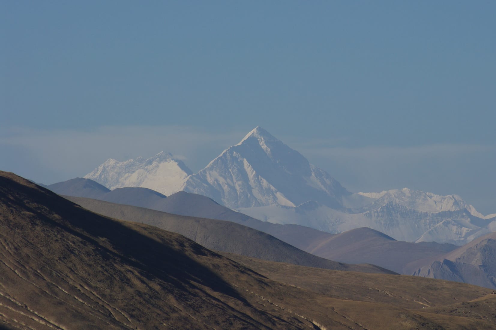
A wall of snow-covered Himalayan peaks rising above brown treeless ridges under a pale blue sky

Tibet, China

Tingri

The Himalayan chain seen across the plateau from Tingri. (Bgabel / Wikimedia Commons · CC BY-SA 3.0)

A small plateau settlement in south-western Tibet at about 4,300 metres, strung along the highway that runs from Lhasa towards the Nepal border. Its reason for fame is the view: on a clear morning the snow wall of the Himalaya, including Everest and Cho Oyu, stands across the plain to the south. Most travellers stop here on the way to the mountain's northern side.

Neighbourhoods

  • The highway strip
    • First-time visitors
    • Hotels and restaurants
    • Close to transport

    Almost everything in Tingri stands along a few hundred metres of the main road — guesthouses, small hotels, truck stops, shops selling oxygen canisters and instant noodles, and restaurants aimed at drivers and tour groups. Vehicles for Everest and the border pass through all day.

    Open in Maps
  • The old village and the ruined fort
    • Historic district
    • Quiet
    • Walking

    Behind the road are mud-brick and stone houses, walled yards and the broken walls of an old fort on the rise above, from which the plain and the mountains open out. It is a short, steep walk from the highway and the best place in town to watch the light change on the peaks.

    Open in Maps
  • The plain and the villages
    • Countryside
    • Views
    • Local life

    Beyond the settlement the valley floor is grazing land and small barley fields cut by streams, with scattered hamlets, stone walls and grazing yaks. Tracks lead south towards the foot of the mountains and are the usual way to get a clear, uninterrupted view.

    Open in Maps

Things to do

Mountains and views

  • Mount Everestviewpoint

    The highest mountain on earth, whose northern side rises beyond the ridges south of Tingri and is visible from the plain on clear mornings.

    Open in Maps
  • Cho Oyuviewpoint

    A broad 8,000-metre peak on the Nepal border due south of the town, and one of the four of the world's six highest mountains visible from Tingri.

    Open in Maps
  • Qomolangma National Nature Preservepark

    The very large protected area covering the Tibetan side of the Everest, Cho Oyu and Shishapangma massifs, entered from the highway near the town.

    Open in Maps

Monasteries and the old town

  • Rongbuk Monasterylandmark

    The monastery in the valley below Everest's north face, among the highest in the world, on the road south from the highway towards the mountain.

    Open in Maps
  • The ruined dzong above the villageviewpoint

    The broken walls of an old fort on the hill behind the settlement, a short climb that gives the widest view of the plain and the Himalayan wall.

    Open in Maps

Short trips from the town

  • Shishapangmaviewpoint

    The only 8,000-metre peak lying entirely within Tibet, west of the town and visible from the highway towards the Nepal border.

    Open in Maps

Seasonal events

  • LosarFebruary or March

    Tibetan New Year, when families gather, new prayer flags go up on the roofs and the village makes offerings for the year.

  • Saga DawaMay or June

    The month commemorating the Buddha's birth, enlightenment and death, marked by pilgrimage, alms-giving and circuits of local shrines.

Eat and drink

Long-standing places and food districts in Tingri. Hours, ratings and directions come from your maps app, always current.

Where people eat

  • Guesthouse and teahouse kitchensrestaurant

    Simple rooms attached to the guesthouses serving butter tea and sweet milk tea, momo dumplings and thukpa noodle soup, with a stove in the middle of the floor.

    Open in Maps
  • Sichuanese truck-stop restaurantsneighborhood

    Kitchens run by migrants from Sichuan along the highway, cooking stir-fries, rice dishes and hotpot for drivers, road crews and tour groups.

    Open in Maps
  • Roadside shopsmarket

    Small general stores stocked with instant noodles, biscuits, dried yak meat, bottled water and tea for the drive on to Everest or the border.

    Open in Maps

Experience Tingri

History

Tingri takes its name from the wider Dingri district, a high valley that has been grazed and farmed for centuries and crossed by traders carrying salt, wool and grain between the plateau and the Nepalese valleys to the south. Passes over the Himalaya lead down to the Khumbu and the Rolwaling, and Sherpa communities live on both sides of the range, in the Khumbu and in Tingri county itself. The Langkor area nearby is associated with the 11th-century Indian teacher Padampa Sangye, whose tradition gave the district a place in Tibetan religious history.

A fort stood on the rise above the village, one of the chain of dzongs that administered the Tibetan countryside, and its ruins still mark the skyline. In the early 20th century Tingri became familiar to outsiders as a staging post on the way to Everest: the British reconnaissance party of 1921 made Tingri Dzong the base for its exploration of the northern side of the mountain, and the expeditions that followed came through the district, and mountaineering has shaped the place ever since.

For much of the later 20th century Tingri was a remote administrative village. The paving of the highway, the growth of climbing and trekking on the Tibetan side of Everest and Cho Oyu, and the rise of domestic tourism turned it into a staging post again, with guesthouses and restaurants along the road. The county administration sits at Shelkar, also called New Tingri, about 87 kilometres to the east, while the old village kept the traffic and the view. A magnitude 7.1 earthquake struck the county on 7 January 2025, killing at least 126 people and destroying houses in villages across the valley.

Culture & Customs

Life here is that of a high Tibetan farming and herding district, lived close to the weather. Households keep yaks, sheep and goats, and many still move animals between winter quarters and summer pasture. Dried dung is stacked in patterns against courtyard walls for fuel, since there is no wood at this altitude, and the roofs carry prayer flags renewed at the New Year.

Buddhist practice runs through the day in small ways: mani walls of carved stones beside the tracks, circuits walked clockwise around shrines, and butter lamps lit in the household altar room. The district's religious memory centres on Padampa Sangye and on the monasteries of the valleys running up towards the mountains, Rongbuk among them, which sits higher than almost any monastery on earth and whose monks have long had dealings with climbing expeditions.

The mountains themselves are held sacred rather than seen as sport: Everest is Chomolungma in Tibetan, a name usually explained as a goddess of the mountain, and offerings are made before journeys towards it. Visitors are asked to keep the usual courtesies — accept tea with both hands, do not touch people's heads, ask before taking photographs, and remember that in a settlement this small a guest is quickly noticed.

Daily Life

Tingri county has some 58,000 people spread over a huge area of high valleys; the roadside settlement of Tingri itself holds fewer than seven thousand, and feels smaller. Households are mostly Tibetan, with Han and Hui newcomers running restaurants, shops and transport businesses along the highway.

Herding and barley farming remain the base of the rural economy, supplemented by the gathering of medicinal plants, seasonal labour on road and building projects, and money earned from tourism: guesthouses, guiding, portering and driving for expeditions and tour groups heading to the Everest area. The season is short, running from late spring to late autumn, and the town is very quiet outside it.

Daily life is organised around light and heat. People are up with the sun, outdoor work is done in the middle of the day, and evenings are spent inside around a stove; electricity and mobile coverage reach the settlement but can be interrupted. Supplies come up by lorry from Shigatse, which sets prices and limits choice. The issues that shape the district are the same as its geography: distance from hospitals and secondary schools, the vulnerability of houses to earthquakes and cold, water for the fields, and how much of the tourist money reaches local households.

Food

Food in Tingri is plateau food, designed for cold and altitude. Tsampa, roasted barley flour, is kneaded with butter tea into a dough and eaten at any hour; po cha, the salted butter tea churned from brick tea and yak butter, is drunk all day and offered to every visitor. Sweet milk tea, sold by the thermos, is the common alternative in the roadside teahouses.

Meat means yak and mutton. Yak is stewed with potato and radish, minced into momos, the steamed dumplings that are the standard order in every kitchen in town, or dried in strips through the winter and chewed raw. Thukpa, a noodle soup, is the other staple meal, and shapale, fried meat pastries, appear when there is a festival or a guest. Dairy is central: yoghurt, soft cheese, and chura, hard cubes of dried cheese carried as a pocket snack.

Little grows at this height beyond barley, potatoes and a few hardy vegetables, so most produce arrives by lorry, and the roadside shops stock instant noodles, biscuits and tinned food for travellers as much as for residents. Sichuanese cooks along the highway provide the other option, with stir-fries and hotpot, and a few kitchens add fried rice and egg dishes for foreign groups. Chang, home-brewed barley beer, is drunk at festivals; bottled beer is sold in the shops, though alcohol at this altitude is best treated with caution.

Planning tools

Budget

Tingri is visited as part of an organised tour, so the vehicle, guide and permits dominate the cost; the town itself is cheap but basic, with simple guesthouses and plain meals. Entry to the Everest area is charged separately, and prices for food and fuel rise with the distance from Shigatse.

Daily Budget Midrange
USD 180–370 (private guide and vehicle, the better hotels, restaurant meals, all permits)
Daily Budget Shoestring
USD 90–150 (shared small-group tour, guesthouse bed, teahouse meals)

Bring cash, warm clothing and any medication needed for altitude: supplies in town are limited and rooms are often unheated.

Best Time to Visit

Late April to early June and September to late October give the clearest air and the best chance of an uninterrupted view of the mountains; October and November are often clearest of all. Summer brings cloud and monsoon moisture from the south that can hide the peaks for days. Winter is bright but bitterly cold and windy.

Suggested Number of Days

Most travellers stop for a single night to break the drive and to sleep at altitude before going higher. Two or three days allow time for the road towards the north side of Everest, walks out onto the plain and a second chance at clear weather.

First Visit
1 night
With Surroundings
2–3 days

Transportation

Movement is by tour vehicle with a guide. Within the settlement everything is within a few minutes on foot. The road to the Everest area and the Rongbuk valley leaves the highway nearby and climbs over high passes; the highway itself continues west and south towards the Nepal border and east towards Shigatse and Lhasa.

Keep passport and permit copies in a pocket rather than in luggage: they are checked at the roadside and at the entrance to the Everest area.

Airport & Station Connections

Tingri sits on the highway roughly 240 kilometres west of Shigatse, a drive of about five hours over several passes, and two days' driving from Lhasa for most tours. Shigatse Tingri Airport, opened in December 2022, is about 90 kilometres away, and the nearest railway station is at Shigatse. The road south towards the Nepal border crossing at Gyirong continues past the town.

Walkability

The settlement is a few hundred metres long and entirely walkable, though the surfaces are rough and dusty and the highway traffic is heavy with lorries. Walks out to the villages and the old fort are short in distance but hard work above 4,000 metres, where even a gentle slope is felt.

Safety

Crime is not a concern, but this is one of the highest places most visitors will sleep: at about 4,300 metres, altitude sickness is common, nights are cold, and medical facilities are very limited, with hospitals hours away by road. Weather changes quickly and the passes can close in snow, and the district lies in an active earthquake zone: a magnitude 7.1 earthquake struck it in January 2025. There are checkpoints on the highway and a visible security presence, and political conversations can create problems for local Tibetans.

Acclimatise in Lhasa and Shigatse first, tell the guide at once about severe headache, vomiting or breathlessness, avoid politics in conversation, and do not photograph checkpoints or personnel. Check current official travel advice before travelling.

Climate

Cold, dry, windy and intensely sunny, with a very large gap between day and night temperatures. What little precipitation there is falls between June and September, when cloud from the Nepalese side often covers the peaks; spring afternoons are frequently dusty and gusty.

Summer
days of about 12–18°C, nights near freezing, with cloud and occasional showers in July and August
Winter
days around 0–5°C, nights far below freezing, with strong wind and little snow on the plain

Local Customs

Village etiquette follows Tibetan custom: walk clockwise around shrines, mani walls and stupas, do not step over food or people's legs, and ask before photographing residents, herders or their children, who are used to being photographed by passing groups and often ask for something in return. Tipping is not customary in China, although guides and drivers on Tibet tours are commonly tipped at the end.

Ask before entering a household courtyard, take tea with both hands, and keep politics and the Dalai Lama out of conversation for the sake of local people.

Common Payment Methods

The currency is the Chinese yuan renminbi. Payment by phone app works in most shops, but the network is patchy and there is no reliable banking in the settlement, so cash brought from Shigatse or Lhasa is essential for guesthouses, meals, entry fees and supplies.