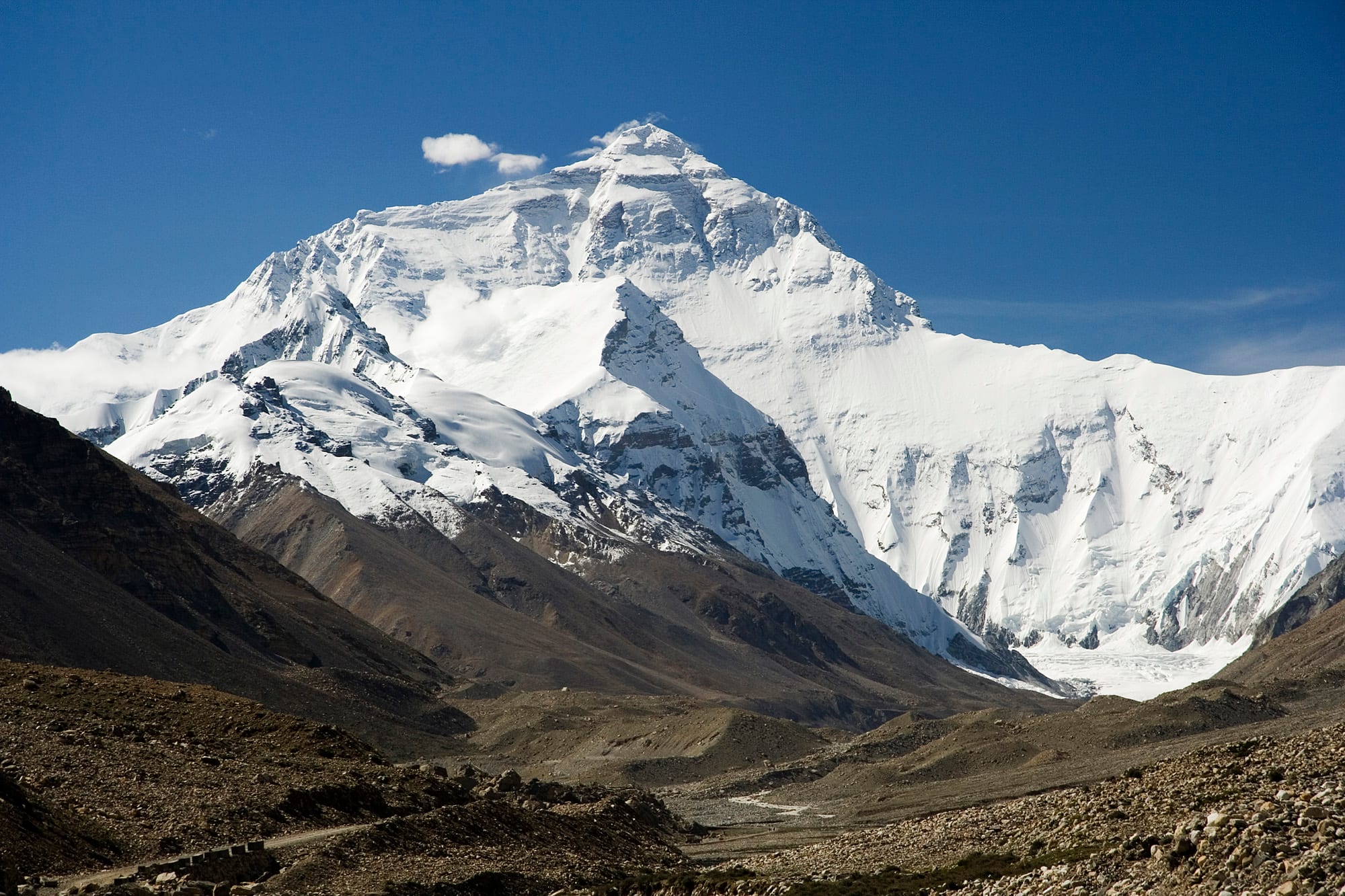
The snow-covered north face of Mount Everest under a deep blue sky, above a bare brown stony valley

China

Tibet

The north face of Mount Everest seen from the Rongbuk valley on the way to the Tibetan base camp. (Luca Galuzzi (Lucag) / Wikimedia Commons · CC BY-SA 2.5)

The Tibet Autonomous Region covers the high western plateau of China, from Lhasa and the Yarlung Tsangpo valley to the Everest massif and the remote lakes of the west — the historic centre of Tibetan Buddhism, governed by China since 1950 in circumstances still disputed, and open to foreign visitors only on permits and guided tours.

Explore Tibet

History

The Yarlung valley south-east of Lhasa was the cradle of the Tibetan empire. Under Songtsen Gampo in the 7th century it became a major Asian power; his marriages to a Nepalese princess and to the Chinese princess Wencheng are linked by tradition to the founding of the Jokhang and the arrival of Buddhism, and Samye, the first monastery, followed in the 8th century. The empire broke up after 842, and Buddhism revived through schools such as the Sakya, whose lamas ruled Tibet under Mongol Yuan patronage in the 13th and 14th centuries.

Tsongkhapa's Gelug school, founded in the early 1400s, came to dominate, and in 1642 the Fifth Dalai Lama, backed by the Mongol Güshi Khan, became head of the Ganden Phodrang government and began the Potala. From the 18th century the Qing kept representatives and garrisons in Lhasa. A British expedition reached the city in 1904, and after the Qing collapsed the Thirteenth Dalai Lama proclaimed independence in 1913, which almost no country formally recognised; Tibet was de facto independent until 1950.

Chinese troops defeated the Tibetan army at Chamdo in 1950, and in 1951 Tibetan delegates signed the Seventeen Point Agreement affirming Chinese sovereignty; Beijing regards it as valid, while the Dalai Lama later said it was signed under duress. After an uprising in 1959 the Fourteenth Dalai Lama fled to India, where a government-in-exile sits in Dharamsala, and the Tibet Autonomous Region was created in 1965. Beijing describes 1950 as a peaceful liberation; the exile government and many Tibetans describe an invasion. Most monasteries were destroyed during the Cultural Revolution and later partly rebuilt. Protests in 1987–89 and 2008 were followed by tighter controls, and the 2006 railway brought faster development and, exiles say, faster Han migration.

Culture & Customs

Tibetan culture is built around Tibetan Buddhism, and religion is visible everywhere: prayer flags on passes, mani stones carved with mantras, prayer wheels turned by pilgrims, and circuits called kora walked clockwise around temples, monasteries and mountains. Pilgrims prostrate themselves full-length along the Barkhor. The pre-Buddhist Bon religion survives and walks its circuits anticlockwise. Religious life is under state control: monasteries are supervised, and the succession of the Panchen Lama has been contested since 1995, when the boy recognised by the Dalai Lama was taken into custody and the government installed its own choice.

Tibetan is the language of daily life, written in its own script, with Mandarin used in government, business and schools. Festivals follow the lunar calendar: Losar, the New Year; Saga Dawa, marking the Buddha's life; and the Shoton, or yoghurt festival, in August, when Tibetan opera is performed.

Customs matter to visitors: walk clockwise around sacred sites, do not touch people's heads, ask before photographing people, and never photograph a sky burial, in which the dead are offered to vultures. Accepting a khata, a white silk scarf, with both hands is a courtesy.

Daily Life

The Tibet Autonomous Region has about 3.6 million people, most of them Tibetan, spread across an area larger than France and Spain combined. Lhasa, with about 870,000 in its wider municipality, is by far the largest city; Shigatse, Nyingchi and Chamdo are smaller regional centres. The old Tibetan quarter of Lhasa, around the Jokhang, is surrounded by a much larger modern city of wide avenues, Han Chinese-run shops and government buildings.

Many rural Tibetans are farmers growing barley in the valleys or nomads herding yaks and sheep on the high grassland, and the spring harvest of caterpillar fungus, prized in Chinese medicine, is a major source of cash. State investment, roads, railways and tourism — overwhelmingly domestic — drive the economy, and government programmes have moved many nomads into permanent settlements.

Daily life starts with butter tea and circuits of the local temple for older Tibetans. Current issues include the pace of Han migration and development, the expansion of Mandarin-medium boarding schools, which exiles and human-rights groups have criticised, and restrictions on religious practice and on travel abroad.

Food

The Tibetan diet is shaped by altitude, where few crops grow. The staple is tsampa, roasted barley flour mixed with butter tea and kneaded into a dough by hand. Po cha, butter tea, is brewed from brick tea, salt and yak butter, and drunk many times a day. Yak meat is eaten fresh, dried in strips or in stews, and sheep and yak cheese is dried into hard cubes, chura, for chewing.

Momos, steamed dumplings filled with yak meat or vegetables, and thukpa, noodle soup, are the everyday restaurant meal, while shapale, fried meat pastries, and yoghurt, often from yak or dri milk, are popular. In Lhasa, crowded teahouses serve tea and bowls of noodles. Larger restaurants also serve Sichuan food, reflecting the many Sichuanese migrants.

Chang is a mild barley beer drunk at festivals and in homes; Lhasa Beer is the local lager. Guests are usually offered tea or chang, which are topped up after every sip; leaving the cup full signals enough.

Attractions & Natural Wonders

Lhasa's Potala Palace, begun under the Fifth Dalai Lama, rises thirteen storeys above the city with the tombs of past Dalai Lamas inside. The Jokhang and the Barkhor pilgrim circuit, the Norbulingka summer palace, and the great Gelug monasteries of Sera, with its afternoon debating monks, and Drepung complete the city. Ganden lies east, and Samye to the south, by the Yarlung Tsangpo.

West of Lhasa, the road passes the turquoise Yamdrok Lake to Gyantse, with its Kumbum stupa and fortress, then Shigatse and the Tashilhunpo Monastery, founded in 1447, with a giant statue of Maitreya. Beyond, the Sakya Monastery precedes the Rongbuk valley, where the Everest north base camp and the Rongbuk Monastery face the mountain's north face; tourists stay at a camp short of the climbers' base camp.

North of Lhasa, Lake Namtso lies below the snow peaks of the Nyenchen Tanglha, with the Tashi Dor monastery and old cave hermitages on the shore. In the far west, Mount Kailash is circled on a kora usually walked in three days, beside Lake Manasarovar, and the ruins of the Guge kingdom stand at Tsaparang. In the south-east, the forests of Nyingchi border the Yarlung Tsangpo Grand Canyon.

Cities in Tibet

Planning basics

Budget

Tibet is one of the most expensive parts of China to visit, because foreign travellers must book an organised tour with a licensed agency, guide and vehicle. Costs fall sharply when the guide and car are shared in a small group. Lhasa's guesthouses and Tibetan restaurants are reasonably priced, but trips to Everest and above all to Kailash add days of driving and permits.

Daily Budget Midrange
USD 180–370 (private guide and vehicle, comfortable hotels, restaurant meals, all permits)
Daily Budget Shoestring
USD 90–150 (shared small-group tour, guesthouses, Tibetan teahouse meals)

Join a small group through a licensed agency to share the guide and car; the agency obtains the permits, so allow several weeks before arrival.

Safety

Crime is low, but altitude sickness is a real danger: Lhasa is at about 3,650 metres, and Everest base camp, Namtso and the Kailash circuit are far higher. There is a heavy security presence, with checkpoints and cameras, and political discussion can put local Tibetans at risk. Images of the Dalai Lama are banned, and photographing police, soldiers or checkpoints should be avoided.

Ascend slowly, drink plenty of water, avoid politics in conversation, and follow the guide's rules on photography in monasteries. Check current official travel advice before travelling.

Climate

High and dry, with strong sun and big swings between day and night. Lhasa, at about 3,650 metres, has warm sunny days much of the year and cold nights; most rain falls in July and August, often overnight. Western Tibet around Kailash is colder and more arid, and the Everest region is bitterly cold and windy outside summer.

Summer
mild days, 15–25°C in Lhasa, cool nights; showers in July and August; colder at Everest and Namtso
Winter
sunny and dry by day, around 5–10°C in Lhasa; nights well below freezing; passes may be snowbound

Transportation

Lhasa is reached by air from several Chinese cities or on the Qinghai–Tibet railway from Xining, a journey of about a day. Railways now run from Lhasa to Shigatse and to Nyingchi. Beyond them, travel is by tour vehicle on long highways: Lhasa to the Everest area takes two days, and Kailash several more. The road to Nepal crosses at Gyirong when the border is open to foreigners.

Spend two or three days in Lhasa before going higher, and carry the passport and permit copies at the many road checkpoints.

Best Time to Visit

April to June and September to October bring clear skies and passable roads; October and November often give the clearest views of Everest. Summer is green and busiest with domestic tourists, while winter is cold but quiet. The region has often been closed to foreign tourists around Tibetan New Year and in March, the anniversary of the 1959 uprising, and Kailash pilgrimages peak at the Saga Dawa festival.