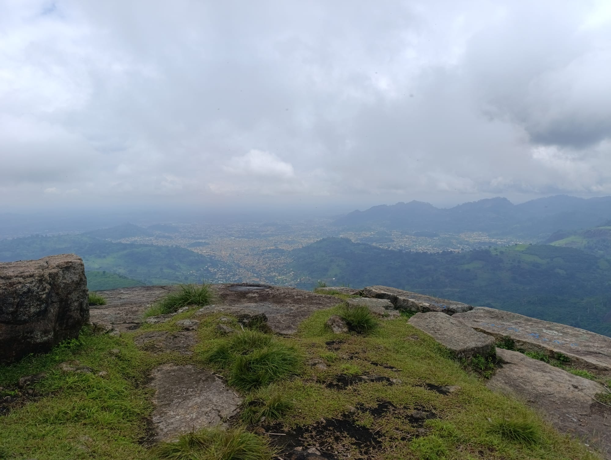
The town of Man spread across a green valley seen from a rocky summit, with forested ridges and low cloud beyond

Yamoussoukro, Man & the Centre-West, Côte d'Ivoire

Man

Man in its valley of forested hills, seen from the rocks of the Dent de Man. (NricDon / Wikimedia Commons · CC BY-SA 4.0)

A town in the far west of Côte d'Ivoire, set in a bowl of forested granite mountains near the Guinean and Liberian borders. Known for the tooth-shaped peak above it, for waterfalls in the surrounding forest and for the Dan villages with their masks and stilt dancers, it is the market and administrative centre of the Ivorian highlands.

Neighbourhoods

  • Centre-ville
    • First-time visitors
    • Markets
    • Close to transport

    The commercial core around the great market, the banks and the bus and shared-taxi yards. Most of the town's hotels, eating places and offices are within a few streets of each other here, and the mountains close the view at the end of almost every road.

    Open in Maps
  • The quarters around the market
    • Local life
    • Best for food

    The residential streets of compounds, small shops and maquis that ring the commercial core, busiest in the evening when the charcoal grills are lit. This is ordinary working Man rather than a sight.

    Open in Maps
  • The university quarter
    • Quiet and residential
    • Local life

    The spread of family houses, gardens and small eating places around the Université de Man on the edge of town, with schools, churches and mosques and a slower pace than the centre.

    Open in Maps
  • The cascade road
    • Walks and greenery
    • Close to the forest

    The lanes leading west out of town towards the waterfall, where the houses give way to coffee, cocoa and kola plots and stands of forest. It is the easiest part of Man to walk for its own sake.

    Open in Maps

Things to do

Mountains and waterfalls

  • Dent de Manviewpoint

    The tooth-shaped granite peak of about 880 metres that stands over the town, climbed with a guide in a few hours for a view across the valley and the surrounding ridges.

    Open in Maps
  • Mont Tonkouiviewpoint

    One of the highest summits in Côte d'Ivoire at about 1,190 metres, north-west of the town, reached by a rough road through forest and often in cloud.

    Open in Maps
  • Cascade de Manattraction

    A waterfall in the forest a few kilometres west of the centre, reached on foot through bamboo and plantation, and fullest during the rains.

    Open in Maps

The town

  • Grand Marché de Manmarket

    The town's central market, where forest produce, rice, palm oil, kola nuts and cloth come in from the surrounding villages.

    Open in Maps
  • Man Airporttransit hub

    The town's airport, a short drive outside the centre; the roads from Abidjan and Yamoussoukro are the usual way in and out.

    Open in Maps

Short trips from the town

  • Biankoumaattraction

    A hill town north of Man in the Dan mountains, the centre for a scatter of villages in the high country and on the way to the Mont Sângbé park.

    Open in Maps
  • Dananéattraction

    A town west of Man near the Liberian border, long associated with the liana bridges of the surrounding villages and with cross-border trade.

    Open in Maps
  • Mont Sangbé National Parkpark

    A national park of savanna woodland with patches of forest, north of Man between Biankouma and Touba, little visited and with few facilities.

    Open in Maps
  • Mont Péko National Parkpark

    A forested massif south-east of Man, made a national park in 1968, with woodland over most of its area and little in the way of visitor facilities.

    Open in Maps
  • Mount Nimba Strict Nature Reservepark

    The Ivorian and Guinean slopes of the Nimba range, a UNESCO World Heritage Site of montane grassland and forest with unusually high numbers of endemic species; it has been on the List of World Heritage in Danger since 1992, and access is restricted.

    Open in Maps

Eat and drink

Long-standing places and food districts in Man. Hours, ratings and directions come from your maps app, always current.

Man classics

  • Rice with leaf saucerestaurant

    In the forest west the staple is rice rather than yam, eaten with thick sauces of pounded leaves, palm oil, groundnut or okra and plenty of chilli.

    Open in Maps
  • Poisson braisé and allocorestaurant

    Grilled fish or chicken with attiéké or fried plantain, the standard maquis meal, eaten outdoors at plastic tables in the cool of the evening.

    Open in Maps
  • Kedjenourestaurant

    Chicken or guinea fowl sealed in a pot with vegetables and chilli and cooked slowly in its own steam, served for guests and celebrations.

    Open in Maps

Markets and food streets

  • Grand Marché de Manmarket

    Mountain rice, cassava, plantain, palm oil, smoked fish, kola nuts and forest fruits, with cooked-food sellers around the edges.

    Open in Maps
  • The maquis of the centreneighborhood

    Open-air grills and bars spread along the streets near the market, where the town eats and drinks after dark.

    Open in Maps

Experience Man

History

Man sits in the mountains of the Dan, or Yacouba, people, who lived in small independent village communities without kings, governed by lineage elders and by the mask societies that settled disputes and initiated the young. Local tradition traces the town's name to Gbê, a Dan patriarch of Gbêpleu, and to his sacrifice at the end of the nineteenth century. Kola nuts, iron and cloth moved through the hills along trade paths linking the forest to the savanna long before any European arrived.

The French reached the western mountains late, and the region was among the last brought under colonial administration. Man was established as a colonial post and the administrative centre for the mountain country that gives the town its nickname, the town of eighteen mountains. Coffee, cocoa and kola were planted on the slopes, a road was pushed through from the east, and the town grew as the market for a scattered rural population.

After independence Man became the regional capital of the west, gaining schools, a hospital, an airfield and a hotel trade that drew visitors to the waterfalls and the mask villages. The conflict that split the country from 2002 left Man on the northern side of the dividing line, administered by the movement that became the Forces Nouvelles, and the west suffered heavily again during the post-election crisis of 2010 and 2011, with violence and large-scale displacement across the region. Since reunification Man has regained its role as the administrative and commercial centre of the highlands, with a university and new road building, and its visitor trade has slowly returned.

Culture & Customs

The Dan are among the best-known mask peoples of West Africa, and around Man the mask is not an object but a spirit with a name, a voice and a history. Different masks judge disputes, guard the initiation of boys in the sacred forest, announce funerals, entertain at festivals or enforce the peace, and each belongs to a lineage that alone may bring it out. The region's mask festivals gather performers from many villages, and the stilt dancers, who dance on poles several metres high in costumes of raffia and cloth, are the most photographed of them.

Village life in the hills keeps other old crafts: weaving, carving, ironwork and the liana bridges strung across rivers in villages around Man and Danané, which are renewed by hand and are the object of their own rituals. Wè, or Guéré, communities live to the south and east and share much of this mask culture.

Religion in the town is mixed. Christian churches and mosques stand near each other, Dioula-speaking traders from the north run much of the market, and traditional practice continues alongside both. Manners are formal: greet before asking anything, defer to elders, use the right hand, and expect an introduction through a local person to be the key to almost everything in the villages.

Daily Life

About 240,000 people lived in Man at the 2021 census, making it the main town of the western mountains and the seat of both the Montagnes District and the Tonkpi Region. Its population is mainly Dan, or Yacouba, with Wobé, Toura and Dioula-speaking communities and long-settled migrants from Guinea, Mali and Burkina Faso; students at the Université de Man and the technical schools add to it in term time.

The economy is farming and trade. Coffee, cocoa, kola, rice, cassava and rubber come in from the surrounding hills to the market and the buying stores, and the town supplies the villages in return with fuel, tools, cloth and building materials. Administration, schools, the hospital and transport employ much of the rest, and iron ore deposits in the mountains have long attracted mining interest.

Days begin early and cool, with the mist still on the peaks; the market is at its busiest in the morning, the afternoon is slow, and the evening belongs to the maquis and the football pitches. Water supply, the state of the rural roads, jobs for young people and the long work of reconciliation after the conflicts are the issues that dominate local conversation.

Food

Rice is the base here, not yam. Mountain rice grown on the slopes is eaten at most meals with thick sauces: sauce graine made from boiled palm nuts, sauce arachide of groundnut paste, okra sauces that pull into threads, and dark, rich sauces of pounded leaves cooked with palm oil and smoked fish. Cassava and plantain fill out the table, and foutou, the pounded dough eaten by hand, appears as often as it does further east.

Forest ingredients give the cooking its character: palm oil pressed in the villages, smoked river fish, snails, peppers, and the kola nuts that are chewed and offered to guests rather than cooked. Grilled food is the evening standard — poisson braisé, whole fish scored and spiced over charcoal, or chicken, served with attiéké, the fermented cassava couscous, or alloco, plantain fried until dark, with a relish of chilli, onion and tomato. Kedjenou, slow-cooked in a sealed pot, is the dish brought out for guests.

Palm wine, called bangui, is tapped in the surrounding villages and drunk fresh; ginger juice, bissap from hibiscus flowers and Ivorian beer are the other common drinks, alongside strong sweet coffee from beans grown on the same hills.

Planning tools

Budget

Man is inexpensive. Hotels are simple and cheap by Ivorian standards, maquis meals cost little, and coach fares from Abidjan or Yamoussoukro are low. The real costs are the guides and the vehicle needed for the mountains and the villages, and village visits usually involve a modest fee or a gift to the chief.

Daily Budget Midrange
USD 80–170 (comfortable hotel, restaurants, a car and driver for the mountain villages)
Daily Budget Shoestring
USD 25–50 (simple hotel, maquis meals, shared taxis and coaches)

Agree guide and village fees before setting out, and carry small CFA notes; cash machines are few and cards are rarely accepted.

Best Time to Visit

November to March is the driest and easiest season, with firmer tracks in the hills and clearer views once the Harmattan haze lifts. The waterfalls are at their strongest during the rains from May to October, but mountain paths turn slippery and some village roads become impassable.

Suggested Number of Days

Two days is enough for the town and one climb or walk nearby. Three or four allow time for the mountain villages, which need a vehicle and a guide and are slow to reach. Wet weather can add a day to any plan here.

First Visit
2 days
With Surroundings
3–4 days

Transportation

Shared taxis and motorbike taxis, known locally as taxis-motos, cover the town and the nearest villages, and the centre is small enough to cross on foot. Coaches connect Man with Abidjan, Yamoussoukro, Daloa and Danané from the stations in the centre. The mountain tracks and the road up Mont Tonkoui need a four-wheel drive or a motorbike and a driver who knows them.

Travel between towns by day, allow for checkpoints on the western roads, and hire a local guide for walks in the hills.

Airport & Station Connections

Most visitors arrive by road. The drive from Abidjan takes a long day, around eight to ten hours depending on the state of the road, and from Yamoussoukro roughly half that; coaches run daily. Man Airport lies a short drive outside the town, but road transport is the usual way in and out.

Walkability

The centre is compact and easily walked, from the market to the hotels and bus yards in fifteen minutes or so. Beyond it the town spreads into the hills, roads climb, and pavements give out, so walking becomes a matter of shade and gradient. The waterfall and the peaks are trips in their own right, on foot from the road head.

Safety

Man is generally calm, with petty theft the usual concern. The far west saw serious violence during the conflicts of 2002 to 2011, and some governments still advise caution towards the Liberian border west of the town. The greater practical risks are road conditions, steep and slippery paths in the rains, and travelling after dark.

Use hotel or app-based transport at night in Abidjan, avoid the northern border strip, and check current advice before travelling to the west. Check local conditions before travelling towards the Liberian border, walk in the hills with a guide, and avoid night driving on mountain roads. Check current official travel advice before travelling.

Climate

Wetter and greener than the centre of the country, and cooler at night because of the altitude. Cloud and mist settle on the surrounding peaks for much of the year.

Summer
rainy from about April to October, typically 21–30°C, humid, with mist on the hills
Winter
drier from November to March, typically 17–33°C, with Harmattan haze and noticeably cool nights

Local Customs

Mask culture is living religion here, not folklore. Masks belong to lineages and societies, some are not to be seen by outsiders, and sacred forests around villages are closed. Arriving in a village means greeting the chief first, usually through a guide, and a small gift or fee is customary. Dress modestly; greetings are long and unhurried.

Ask permission before photographing people, dancers or masks, expect to pay a fee for a masked performance, and never enter a sacred grove or take a photograph after being asked not to.

Common Payment Methods

The currency is the West African CFA franc (XOF). This is a cash town: the market, taxis, guides and maquis all want notes, and only the larger hotels may take a card. Cash machines exist in the centre but can be unreliable, so it is worth arriving with enough francs for several days.