Aerial view of grey-roofed market halls beside a wide dry riverbed, with a town among trees and hills beyond

Barahona & the Southwest, Dominican Republic

Pedernales

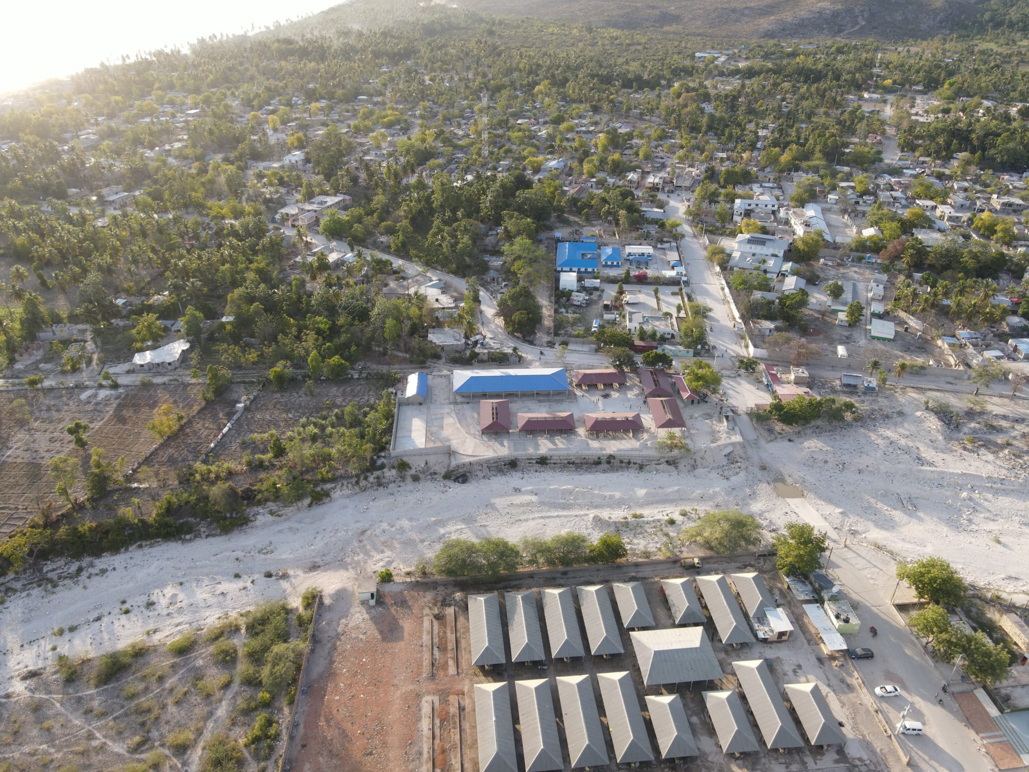
The Pedernales market, in the foreground, across the river from Anse-à-Pitres in Haiti. (Mv51691 / Wikimedia Commons · CC BY-SA 4.0)

The capital of Pedernales province, at the south-western tip of the country on the Haitian border, facing Anse-à-Pitres across the Pedernales River. Founded as a farming colony in 1927, it is a small, hot town of fishing, cattle and farming, and the base for Bahía de las Águilas, Jaragua National Park and the Bahoruco mountains.

Neighbourhoods

  • The town centre and Parque Central
    • First-time visitors
    • Best for food
    • Local life

    A small, easily walkable grid of streets around the central park, where small eateries open in the evening for people coming back from the beach. Simple guesthouses, shops and the provincial offices are close by.

    Open in Maps
  • The waterfront and Playa Pedernales
    • Beaches
    • Quiet stays

    The town's own beach lies on the Caribbean a short walk from the centre, a local place for swimming and evening walks.

    Open in Maps
  • The border by the Pedernales River
    • Local life
    • Markets

    The town ends at the Pedernales River, which marks the southern end of the border with Haiti. The crossing to Anse-à-Pitres is one of the four main land crossings between the two countries, and the town's market lies by the river, across from the market of Anse-à-Pitres.

    Open in Maps

Things to do

In and around the town

  • Playa Pedernalesbeach

    The town beach on the Caribbean, within walking distance of the centre.

    Open in Maps
  • Río de Paso Senapark

    A river site listed among the municipality's places to visit.

    Open in Maps

Short trips: the coast

  • Bahía de las Águilasbeach

    An 8 km beach inside Jaragua National Park, about 25 km from Pedernales, reached by boat, on foot or by four-wheel drive from the fishing village of La Cueva at Cabo Rojo.

    Open in Maps
  • Cabo Rojo and La Cuevaattraction

    The red headland where the fishing village of La Cueva, named after the caves around it, is the starting point for boats to Bahía de las Águilas.

    Open in Maps

Short trips: parks and mountains

  • Jaragua National Parkpark

    The largest protected area of its kind in the Caribbean, created in 1983 to protect dry forest, mangroves, lagoons and sea, and including Beata Island and Bahía de las Águilas.

    Open in Maps
  • Sierra de Bahoruco National Parkpark

    The mountain national park rising inland from Pedernales, created in 1983, with large areas of pine forest, broad-leaved trees and mixed forest.

    Open in Maps
  • Hoyo de Pelempitoviewpoint

    Listed among the places to visit around Pedernales.

    Open in Maps
  • Lago de Oviedopark

    A saltwater lagoon in Jaragua National Park known for its many birds, including flamingos.

    Open in Maps

Eat and drink

Long-standing places and food districts in Pedernales. Hours, ratings and directions come from your maps app, always current.

Pedernales classics

  • Eateries around Parque Centralneighborhood

    Small food stalls and eateries around the central park open at night to feed people coming back from a day at the beach.

    Open in Maps
  • La Cueva fishing villageneighborhood

    The fishing village at Cabo Rojo where boats leave for Bahía de las Águilas.

    Open in Maps

Experience Pedernales

History

People lived in the region in colonial times, but the town itself is young. It was founded in 1927, when the government of Horacio Vásquez set up an agricultural colony here, placed under the protection of the Virgin of Altagracia, as part of the municipality of Enriquillo. The writer Sócrates Nolasco was appointed its administrator, and most of the first colonists came from Duvergé; the first was Genaro Pérez Rocha, a prosperous rancher who later brought the first families to settle.

The name comes from pedernal, Spanish for flint, a yellowish quartz that strikes sparks and is found in the Pedernales River, which marks the southernmost part of the border between the Dominican Republic and Haiti. In 1937 a road linking the colony with Oviedo was built by 500 men working in brigades of ten, and in 1938 Pedernales became a municipal district. When Pedernales province was created in 1957, split from Barahona, the town became its capital. Bauxite was once mined in the area.

In recent decades the coast has become the focus of national plans for tourism. Bahía de las Águilas, the subject of a long dispute over its ownership, was declared public land and placed within a wide government development plan, and the authorities have said that no construction will take place in protected zones. In 2024 the government chose to build a new international airport in the province rather than enlarge the airfield at Cabo Rojo.

Culture & Customs

Pedernales lives on the frontier. Across the river lies the Haitian town of Anse-à-Pitres, and the crossing between them is one of the four main land crossings between the two countries. The town's market lies by the river, facing the market of Anse-à-Pitres, and the border area has a heavy military presence and checkpoints. Anse-à-Pitres is a commune in Haiti's Sud-Est department, and Pedernales is twinned with Villagonzalo Pedernales in Spain.

Local cultural life is small and community-run. The town has a folkloric dance group, a baton ballet and a music band, and palos y atabales, the Dominican sacred drum music played at religious ceremonies on saints' days, are part of local tradition. Cockfighting is a popular pastime.

The landscape shapes local identity. Pedernales sits between two national parks — Jaragua along the coast and the Sierra de Bahoruco inland — which, with Lake Enriquillo and parts of the municipality, formed the country's first biosphere reserve.

Daily Life

At the November 2022 census the municipality of Pedernales had about 24,400 people, about 85 per cent of them in urban areas, and it holds roughly seven-tenths of the population of the whole province. It is a small town with a slow pace, where much of daily life happens around the central park and the streets near the border.

Beef cattle, farming, mining and fishing are the main activities. Cattle and goats graze the savanna of Sansón, sometimes half-wild, and the fishing boats work mainly around Beata Island, where lobster and conch are the important catches.

Tourism, mostly by Dominican visitors, has grown markedly because of the region's landscapes. Bahía de las Águilas and the Sierra de Bahoruco park are the main draws, and the government has development plans for the coast and has chosen to build a new international airport in the province. The town is a long drive from the rest of the country.

Food

Food in Pedernales comes from the sea and the dry savanna. Lobster and conch, known in Spanish as lambí, are caught around Beata Island and eaten with fresh fish, tostones, twice-fried green plantain, and rice. Local fishermen also work from La Cueva on Cabo Rojo, where the boats leave for Bahía de las Águilas.

Goats and beef cattle graze the savanna of Sansón, so goat and beef are local meats. Everyday lunch follows the Dominican pattern of la bandera — rice, beans and stewed meat — and casabe, a flat cassava bread with Taíno roots, is served with soups and stews. Beans and coffee, the main crops, are both grown in the mountains of the municipality.

In the evenings small food stalls and eateries around the central park serve quick meals to people back from the beach. Strong, sweet coffee starts the day, and Presidente beer and rum are drunk in the colmados after dark.

Planning tools

Budget

Pedernales is cheap: small, locally run guesthouses, comedores and the evening food stalls cost little. The real costs are getting here and getting out to the coast — a boat or a four-wheel-drive trip to Bahía de las Águilas, a driver for the parks, and fuel for long drives.

Daily Budget Midrange
USD 85–170 (better hotel or eco-lodge, restaurants, a boat to Bahía de las Águilas, a driver or hire car)
Daily Budget Shoestring
USD 35–60 (guesthouse, comedor meals and street food, guaguas)

Bring enough pesos for trips out to the beaches and parks.

Best Time to Visit

November to April, when the heat is more bearable and the coast is at its driest. Rain is heaviest in September and October, when tropical storms can reach the island, and the summer months are very hot.

Suggested Number of Days

Two or three days are enough for the town and the boat trip to the beach. Four to six allow time for the mountains, the lagoons of the national park and the long drives between them. Sea conditions and the state of park tracks can change the number.

First Visit
2–3 days
With Surroundings
4–6 days

Transportation

The town is small and easy to walk. Beyond it, transport is thin: boats to the beach are hired at La Cueva, and the parks and mountain roads are best reached by hire car or with a driver, ideally in a four-wheel drive. Guaguas link Pedernales with Barahona.

Fill up with fuel in town, carry water, and avoid driving at night.

Airport & Station Connections

Most visitors drive from Santo Domingo or Barahona along the coast road through Oviedo, a long journey; buses from Barahona are hard to catch late in the day. Cabo Rojo Airport, a small daytime domestic airfield in the province, has regular flights to La Isabela International Airport in Santo Domingo. A new international airport for the province has been planned.

Walkability

The town is small and easily walked, from the central park to the beach and the river. Everything else — Cabo Rojo, the beach of Bahía de las Águilas and the parks — needs a vehicle or a boat, and the heat makes long walks in the open punishing.

Safety

The main tourist areas are heavily policed and generally safe, but the Dominican Republic has significant crime, and petty theft, scams, and occasional armed robbery affect visitors, particularly in Santo Domingo and Santiago. In the south-west, crime is lower than in the big cities, but the region is remote, with long stretches without phone signal, fuel or medical care. The border area has a heavy military presence, checkpoints and smuggling, and the situation across the frontier in Haiti, where armed gangs control large areas, is volatile; crossings can close without notice. Heat, flash floods and hurricanes are the main natural risks.

Carry identification for checkpoints, take water and sun protection on beach and park trips, and do not cross into Haiti without checking the latest official advice. Check current official travel advice before travelling.

Climate

A hot semi-arid climate, among the warmest and driest in the country, because the mountains of Hispaniola block the rain carried by the trade winds. Temperatures stay high all year, by night as well as by day, and most rain falls in September and October.

Summer
very hot across the south-west, reaching 33–38°C by day in the Enriquillo basin inland, with the heaviest rain in September and October and a hurricane risk
Winter
warm and dry across the south-west, around 28–31°C by day

Local Customs

Pedernales is a small frontier town where Spanish is the everyday language. People greet each other on the street, and beachwear stays on the beach. Cockfighting and folk music with drums are part of local tradition.

Ask before photographing people, especially at the border and in the markets, and never photograph military posts or checkpoints.

Common Payment Methods

The currency is the Dominican peso. Cash is the norm in Pedernales: the guesthouses, food stalls, boatmen and market traders all expect pesos, and cards are accepted only in a few larger places. Cash machines are few.