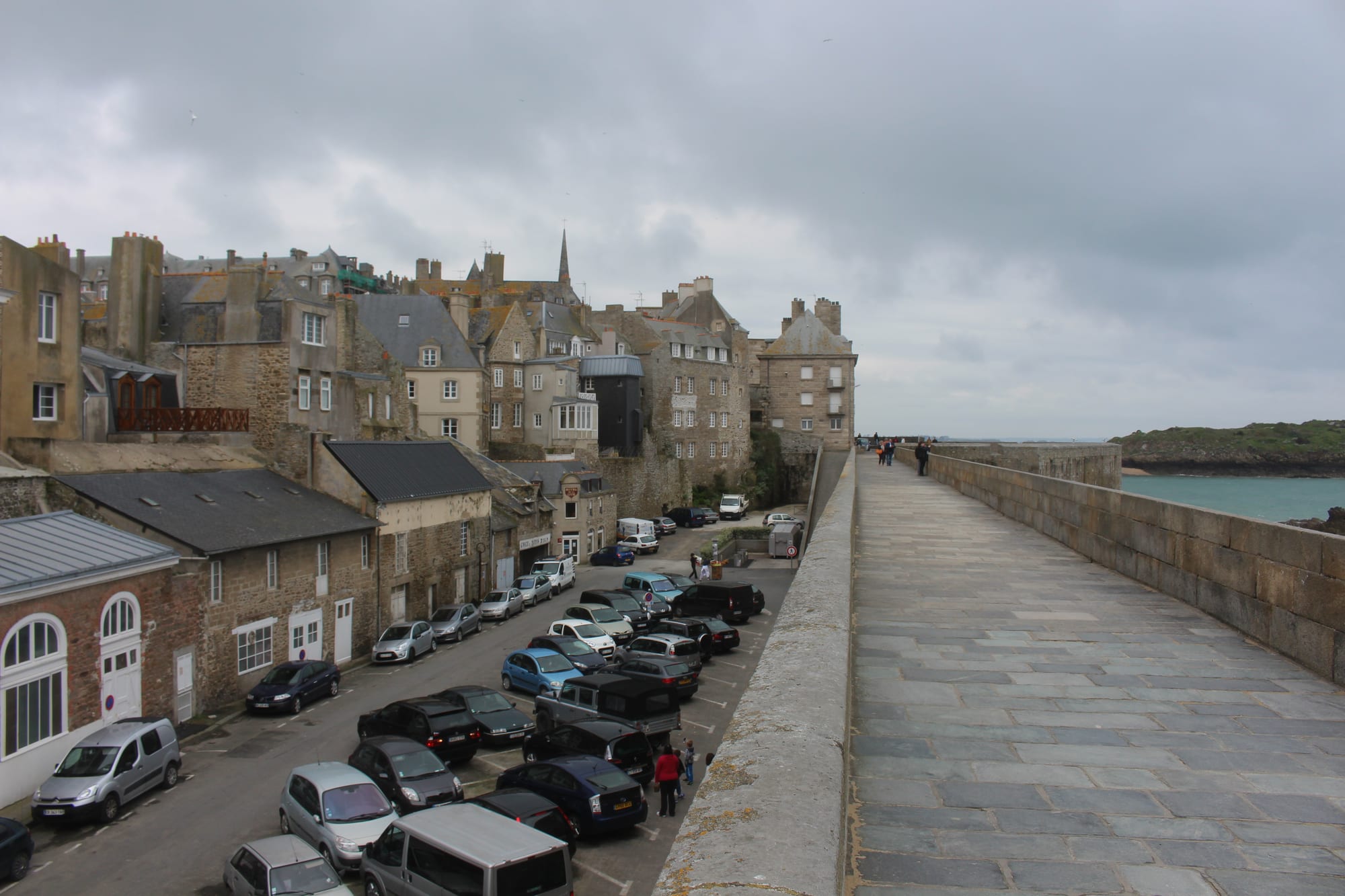
The broad paved rampart walk of Saint-Malo beside tall granite houses and the cathedral spire, with the sea on the right

Brittany, France

Saint-Malo

The ramparts and granite houses of Saint-Malo's walled city, intra-muros. (tiger rus / Wikimedia Commons · CC BY 3.0)

A walled port on the Emerald Coast of north-eastern Brittany, at the mouth of the Rance, that grew rich on trade, exploration and privateering — the home port of Jacques Cartier and the corsairs. Almost destroyed in 1944 and rebuilt between 1948 and 1960, it is now the most visited place in Brittany, a ferry port for England and the Channel Islands with long beaches and some of Europe's largest tides.

Neighbourhoods

  • Intra-muros
    • First-time visitors
    • Historic district
    • Best for food

    The walled city on its former island, rebuilt after 1944 in a historic style, though not as an exact copy, inside ramparts that survived the war. The cathedral, crêperies and shops fill a tight grid of streets inside the ring of walls, which can be walked all the way round, with the beaches, forts and tidal islands below.

    Open in Maps
  • Saint-Servan
    • Local life
    • Best for food
    • Harbour views

    A separate town until 1967, south of the walled city on the Rance estuary, known for its shops and restaurants. The Solidor Tower guards its harbour, and the Aleth peninsula beside it holds the remains of the first settlement and a Roman fort.

    Open in Maps
  • Paramé
    • Beaches
    • Quiet and residential

    The former seaside resort to the east, merged into Saint-Malo in 1967, with villas behind the long sandy beach that runs along the north coast. It is the place for a beach holiday rather than for sights.

    Open in Maps
  • The Sillon and the station districts
    • Beaches
    • Close to public transport

    The sea wall and road along the old sand spit that joined the island to the mainland, with the beach in front and districts such as Rocabey and Marville behind, where the railway station stands about 1.5 km east of the walls.

    Open in Maps

Things to do

The walled city

  • The rampartslandmark

    The walls that ring intra-muros entirely, free to walk at any hour, with views over the bay as far as the Pointe de la Varde.

    Open in Maps
  • Saint-Malo Cathedrallandmark

    The cathedral of Saint Vincent at the heart of intra-muros, a mix of Romanesque and Gothic begun in the 12th century, which replaced the earlier cathedral at Aleth.

    Open in Maps
  • Château de Saint-Malolandmark

    The castle at the north-east corner of the walls, also called the Château de la Duchesse Anne, whose keep was completed in 1424; part of it houses the town hall.

    Open in Maps
  • Demeure de Corsairemuseum

    A ship-owner's town house of 1725 on Rue d'Asfeld, with exhibits on privateering, weapons and ship models.

    Open in Maps

Forts and tidal islands

  • Fort Nationallandmark

    Vauban's fort of 1689 on a tidal island a few hundred metres off the walls, reached on foot only when the tide is out.

    Open in Maps
  • Grand Béattraction

    A tidal island reached at low tide from Bon-Secours beach, where Chateaubriand is buried in a grave facing the sea.

    Open in Maps
  • Petit Béattraction

    The smaller tidal island beyond Grand Bé, with a fort built from 1689 and partly restored.

    Open in Maps
  • Fort de la Conchéeviewpoint

    A Vauban fortification covering almost the whole of the rocky island of Quincé, four kilometres out to sea.

    Open in Maps
  • Cézembreattraction

    An uninhabited island in the bay with a sandy beach facing the town, reached by shuttle boats in summer; its German battery held out until September 1944.

    Open in Maps

Museums and the seafront

  • Solidor Towerlandmark

    A keep of three linked towers in the Rance estuary at Saint-Servan, built in 1369–82 by John IV, Duke of Brittany; its Cape Horn museum closed for good in 2022.

    Open in Maps
  • Great Aquarium Saint-Maloattraction

    An aquarium opened in 1996 with about 11,000 marine animals of 600 species, one of the most visited sights in Brittany.

    Open in Maps
  • Bon-Secours tidal poolbeach

    The sea-water swimming pool on Bon-Secours beach below the walls, filled and emptied by the tide.

    Open in Maps
  • Pointe de la Vardeviewpoint

    A headland across the bay from the walled city, in full view from its ramparts.

    Open in Maps

Short trips from the city

  • Rance Tidal Power Stationlandmark

    The dam across the Rance estuary, opened in 1966 as the world's first tidal power station, with a road across its top and a lock for boats.

    Open in Maps
  • Dinardattraction

    The resort across the Rance estuary, known for its villas, beaches, casino and film festival.

    Open in Maps
  • Cancaleattraction

    A fishing port on the bay east of the city, called the oyster capital of Brittany, with an oyster market on the harbour and oyster beds visible at low tide.

    Open in Maps
  • Dinanattraction

    A walled Breton town in the neighbouring Côtes-d'Armor department.

    Open in Maps
  • Mont-Saint-Michellandmark

    The abbey on its tidal rock in the bay across the Norman border.

    Open in Maps

Seasonal events

  • La Route du RockAugust, with a winter edition in February or March

    A rock festival whose summer edition has brought acts such as Massive Attack, The Flaming Lips and The National; since 2006 it has also held a winter event.

  • Route du RhumNovember, every four years

    The single-handed transatlantic yacht race from Saint-Malo to Pointe-à-Pitre in Guadeloupe, whose fleet gathers in the city's harbour before the start.

Eat and drink

Long-standing places and food districts in Saint-Malo. Hours, ratings and directions come from your maps app, always current.

Saint-Malo classics

  • Crêperies of intra-murosneighborhood

    The walled city's streets hold many crêperies serving savoury buckwheat galettes, some with seafood, and sweet crêpes.

    Open in Maps
  • Cancale oyster marketmarket

    The oyster stalls on the harbour at Cancale, where a wide variety of local oysters is sold at producers' prices.

    Open in Maps

Food districts

  • Saint-Servanneighborhood

    The old town on the Rance south of the walls, known for its shops and restaurants and quieter than intra-muros.

    Open in Maps

Experience Saint-Malo

History

Gauls settled here in the 1st century BC, and the Roman town of Reginca or Aletum stood on the Aleth peninsula, where by the late 4th century a fort of the Saxon Shore guarded the Rance against raiders. Early in the 6th century a monastic settlement was founded by Saint Aaron and Saint Brendan; the town is named after Malo, or Maclou, a follower of Brendan who had come from what is now Wales. In the Middle Ages the town grew on a granite island off the coast, and in the mid-12th century its cathedral took over the bishop's seat from Aleth. A road and stonework were first laid along the Sillon, the sand spit to the mainland, in 1509.

The Malouins had a habit of independence: from 1590 to 1594 the town ran itself as a republic, and its motto still declares its people neither French nor Breton but Malouin. Jacques Cartier sailed from here to the St Lawrence, and Saint-Malo became notorious as the home of the corsairs, privateers who made English ships pay tribute; René Duguay-Trouin took Rio de Janeiro in 1711 and Robert Surcouf raided British shipping. In 1764 Bougainville named the Falklands the Îles Malouines after the town's settlers, the origin of the Spanish Malvinas.

In August 1944 the walled city was almost totally destroyed by American shelling and bombing while its German commander refused to surrender; the citadel held out until 17 August and the island of Cézembre until 2 September. The old town was rebuilt between 1948 and 1960, and in 1967 Saint-Servan and Paramé were merged into the commune.

Culture & Customs

Saint-Malo's identity is maritime and stubborn. Its sea captains, explorers and corsairs are commemorated in street names, museums and the shipowners' houses inside the walls, and the town also has names in Gallo, Saent-Malô, and Breton, Sant-Maloù. François-René de Chateaubriand, born here in 1768, described the town of his childhood in his Memoirs from Beyond the Grave and chose to be buried on the Grand Bé, facing the sea.

The sea also sets the calendar. Every four years in November the Route du Rhum single-handed yacht race leaves for Pointe-à-Pitre in Guadeloupe. La Route du Rock, a music festival held each August, has also held a winter event since 2006, and the town's Étonnants Voyageurs festival now presents the Grand prix de l'Imaginaire, a French literary award for speculative fiction.

The rebuilt city has a literary life of its own. Saint-Malo is one of the main settings of Anthony Doerr's Pulitzer Prize-winning novel All the Light We Cannot See, set during the siege of 1944, and was a filming location for the Netflix series based on it. Even in summer, much of the town's character comes from the tides, which reshape the shore twice a day and set the hours for walking out to the islands.

Daily Life

The commune had about 47,000 residents in 2023 and the wider urban area about 138,000 in 2022, but the summer season can push the number of people in town up to around 300,000. Saint-Malo is a subprefecture of Ille-et-Vilaine and the most visited place in Brittany, and tourism, the ferry port and the harbour drive much of the economy, alongside an institute of technology, a nursing school and a maritime school.

Many Malouins live in the districts that grew up on the mainland — Rocabey, Marville and the streets around the station — in the old town of Saint-Servan, with its own harbour and shopping streets, and in Paramé behind the long beach. Rennes, the regional capital, is about an hour away by train.

Life follows the tides and the seasons: low water opens the causeways to the tidal islands, high water covers the causeways again, and between October and March the walled city quietens. Regular ferries to England and the Channel Islands keep a steady flow of British and island visitors through the port year round.

Food

Saint-Malo eats like the rest of Brittany, and the crêperie is the everyday restaurant. A Breton galette is a savoury pancake made with buckwheat flour, and sweet crêpes follow as dessert. Kouign-amann, a round Breton cake of laminated dough with layers of butter and sugar baked slowly until the sugar caramelises, originated in Douarnenez around 1860 and is sold in bakeries across the town. Far breton is a dense baked custard-like cake similar to a clafoutis batter, usually with prunes or raisins.

Seafood comes from the bay. Oysters from nearby Cancale, the oyster capital of Brittany, are the local pride, sold at producers' stalls on Cancale's harbour and served in the city's restaurants, along with mussels and seafood platters.

The drinks are Breton too: cider, local beers and chouchen, a mead made by fermenting honey in water, traditionally with buckwheat honey, of about 14 per cent alcohol and drunk chilled as an aperitif. Calvados from neighbouring Normandy, an apple or pear brandy, also appears at the end of many meals.

Planning tools

Budget

Saint-Malo is moderately priced most of the year but becomes expensive in July and August, when the population of under 50,000 can swell to as many as 300,000 and rooms inside the walls are scarce. Crêperies are the cheapest sit-down meal; seafood platters are the splurge. Ferries, island boats and parking add up.

Daily Budget Midrange
USD 150–270 (hotel near the walls or the beach, seafood dinners, the aquarium and museums, a day trip by car)
Daily Budget Shoestring
USD 80–120 (hostel or campsite, galettes and bakery lunches, local buses)

The ramparts, beaches and walks to the tidal islands cost nothing; the park-and-ride car park outside the centre avoids the crowded parking near the walls.

Best Time to Visit

May to September, when the beaches and island walks are at their best; June and September are calmer than the crowded high summer. The great tides, among the largest in Europe, with a range of up to 14 metres, are a spectacle of their own. Winter is quiet, mild and often stormy.

Suggested Number of Days

Two days cover the walled city, the seafront and the tidal islands, whose visits depend on the times of low tide. Four or five days allow for the neighbouring towns and the coast of the bay. Summer crowds and tide tables decide how much fits into each day.

First Visit
2 days
With Surroundings
4–5 days

Transportation

Walking is the best way to see the walled city, and the seafront promenade links it with the Sillon and Paramé. MAT buses run to the outlying districts and neighbouring towns, taxis wait at the station and the entrance to the old town, and a small tourist train runs in season. A road runs across the Rance tidal dam to Dinard. A car is useful for the wider coast but a burden in the centre, where parking is tight.

Use the park-and-ride on Rue Paul Féval and take the bus into the centre on busy days.

Airport & Station Connections

Saint-Malo station, about 1.5 km east of the walls, has direct TGV trains from Paris Montparnasse and regular trains to Rennes, about an hour away. The nearest airport with scheduled flights is Rennes, about 75 km south. Brittany Ferries sail from Portsmouth and from Poole via Guernsey, and DFDS from Jersey, to the ferry terminal about 500 metres south of the walled city. By road Saint-Malo is about 70 km from Rennes.

Walkability

Intra-muros is small, car-restricted in places and easy on foot, and the rampart walk runs right round it. The station, the ferry terminal and Saint-Servan are all within walking distance, though the station walk is longer than it looks. The promenade along the Sillon makes a long, flat seaside walk east towards Paramé.

Safety

France is a safe country overall, with violent crime against visitors uncommon. In Saint-Malo the real risks come from the sea: the tidal range is among the largest in Europe, reaching 14 metres, and several accidents have happened to people caught out by the tide times on the way to the tidal islands such as the Grand Bé.

Check the tide times before walking out to Fort National, the Grand Bé or the Petit Bé, keep well back from the sea in a storm, and keep valuables out of sight in crowded summer streets. Check current official travel advice before travelling.

Climate

Oceanic and softened by the Gulf Stream, with a small gap between winter and summer, frequent wind and showers, and an average annual temperature of about 11.6°C.

Summer
mild and breezy — August, the warmest month, averages about 18°C
Winter
mild and wet — January averages about 6°C, and Atlantic storms bring big seas

Local Customs

A 'bonjour' on entering any shop, café or crêperie is expected. Service is included in restaurant bills, so tipping is modest — rounding up or leaving a little for good service. Malouins are proud of the city's independent streak. In crêperies cider is traditionally drunk from a bowl.

Respect the war memorials and the cathedral during services, and keep beachwear for the beach rather than the streets inside the walls.

Common Payment Methods

The currency is the euro. Cards and contactless payment are accepted almost everywhere, including car parks and most crêperies; a little cash helps at markets and small stalls. Cash machines are easy to find inside the walls and around the station.