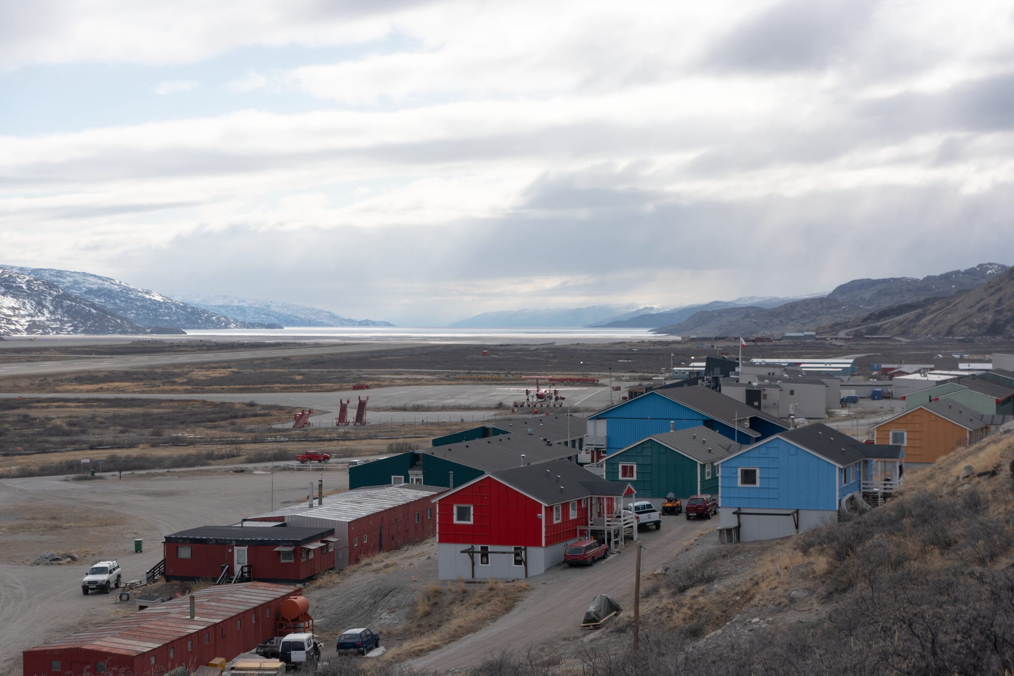
Red, blue and green wooden buildings on a slope above a wide flat valley with an airfield, a fjord and snowy hills beyond

Greenland

Kangerlussuaq

Kangerlussuaq, with the airfield and the head of the Kangerlussuaq Fjord beyond. (Quintin Soloviev / Wikimedia Commons · CC BY-SA 4.0)

A settlement of about 400 people at the head of the long Kangerlussuaq Fjord in western Greenland, just north of the Arctic Circle. Built around a US air base from 1941 and handed to Greenland in 1992, it was the country's main air hub until 2024 and remains the only place in Greenland with road access to the ice sheet.

Neighbourhoods

  • The original settlement
    • First-time visitors
    • Close to the airport

    The side of town around the airport terminal, where the supermarket, the post office, the museum and most of the services stand within a few minutes' walk of the runway, among low wooden buildings on the slope above the valley floor.

    Open in Maps
  • The former military area
    • History
    • Quiet and residential

    The old base on the opposite side of the airfield, built during the US occupation of the site. Many of its barracks have been converted for civilian use, including accommodation for visiting scientists.

    Open in Maps

Things to do

Around the town

  • Kangerlussuaq Museummuseum

    A local history museum across the road from the airport, run by the museum in Sisimiut, telling the story of the base and the settlement.

    Open in Maps
  • Tundra walkstrail

    Walks on the open tundra around town, where caribou, musk oxen and Arctic hares can be seen; the area has the most varied land wildlife in Greenland.

    Open in Maps
  • Kellyville radar dishlandmark

    The large dish of the former upper-atmosphere research station about 15 km west of town, which ran from 1983 to 2018; the buildings were demolished in 2023 but the dish remains.

    Open in Maps

The ice sheet and short trips

  • Russell Glacierlandmark

    An outlet glacier of the ice sheet whose front lies about 25 km east of town; its edge is easy to reach and is a major tourist attraction from the town.

    Open in Maps
  • The ice sheet road (Point 660)trail

    A gravel road of about 35 km built in 1999 for Volkswagen's winter car testing, running through the Isunngua highlands to the edge of the Greenland ice sheet; it now serves tourism and research.

    Open in Maps
  • Arctic Circle Trailtrail

    The most popular hike in Greenland, running about 165 km from Kangerlussuaq to Sisimiut on the coast, with huts along the route.

    Open in Maps
  • Kangerlussuaq Fjordattraction

    The 190 km fjord the town stands at the head of, navigable along its whole length, with boat tours and, in winter, ice fishing and dog sledding on the ice.

    Open in Maps

Eat and drink

Long-standing places and food districts in Kangerlussuaq. Hours, ratings and directions come from your maps app, always current.

Kangerlussuaq classics

  • Airport cafeteria and restaurantrestaurant

    The airport cafeteria has been the largest of the town's few eateries, with sandwiches, burgers and curries, and the restaurant beyond it has offered Greenlandic dishes of reindeer, musk ox and Arctic char.

    Open in Maps
  • Pilersuisoq supermarketmarket

    The small supermarket across the street from the airport terminal, with groceries and a small range of hot foods reheated at the counter.

    Open in Maps

Experience Kangerlussuaq

History

Kangerlussuaq began as a wartime airfield. After Germany occupied Denmark in 1940, the United States took over Greenland's security, and on 7 October 1941 the US Army Air Forces founded Bluie West-8 at the head of the fjord, under Colonel Bernt Balchen. The base passed briefly to Denmark in 1950, but Cold War worries brought the Americans back, and on 27 April 1951 it reopened as Sondrestrom Air Base. Its main task was to supply and control the DYE radar stations, two of them on the ice sheet, which formed an extension of the Distant Early Warning Line.

In the mid-1950s transatlantic airliners began refuelling here, and in 1956 Scandinavian Airlines flew a polar route from Copenhagen via Søndre Strømfjord to Winnipeg and Los Angeles. Refuelling stops declined in the 1960s as aircraft gained range, but the airport remained Greenland's main gateway, the only civilian field able to take large long-range jets.

The end of the Cold War closed the radar stations, and the last US Air Force personnel left on 30 September 1992. The base passed to Greenlandic home rule, took the Greenlandic name Kangerlussuaq, "big fjord", and became a settlement, although almost all of its permanent buildings date from the American years. Only in 2002 did the municipality take over public services. In November 2024 the rebuilt Nuuk Airport took over the hub role, and the population fell by 30 per cent in a single year.

Culture & Customs

Kangerlussuaq is unlike any other town in Greenland. It grew around an airfield, not a harbour or a trading post, and it is the only town in Greenland not on the open sea. The American legacy is everywhere: the buildings, the road network, and even the electricity, supplied at the US frequency of 60 Hz rather than the 50 Hz used in the rest of Greenland.

Science is part of the town's identity. Easy access to the ice sheet by road and air has made it a base for research on Arctic ecosystems, geology and the atmosphere, and the Greenlandic government offers scientists support and accommodation in converted barracks through a company owned by Greenland Airports. From 1983 to 2018 the Kellyville facility west of town studied the upper atmosphere with a large radar dish, and car makers have long used the roads and the ice as a cold-weather proving ground.

Outdoor life is the rest of it. The area has Greenland's most varied land wildlife, including musk oxen — 27 of them were introduced to the highlands south-east of town — caribou and gyrfalcons. Winter brings dog sledding and ice fishing on the fjord, and the town once had one of the most northerly golf courses in the world, though it is no longer in use.

Daily Life

Kangerlussuaq had 399 inhabitants in 2025, down from 564 a year earlier after Air Greenland moved its hub to Nuuk. Almost the whole economy rests on the airport, tourism and support for scientific research, and nearly all buildings in town are owned and run by Greenland Airports, though since 2002 functions have slowly passed to the municipality and some buildings have been privatised.

The town's future has been uncertain since it lost the hub. It still has the longest civilian runway in Greenland and the most stable weather, so it remains a diversion airport, and when weather and security problems hit Nuuk Airport in 2025 it served again as a temporary hub. Tourism, much of it now in private hands since the 2010s, centres on the ice sheet, Russell Glacier and the Arctic Circle Trail.

New links may change the town's position. A rough 130 km track for all-terrain vehicles to Sisimiut opened in 2025, built between 2021 and 2025, and plans approved in 2018 foresee a deeper port with a new access road west of the present harbour, which is shallow and served by cargo ships only twice a year.

Food

Almost everything eaten in Kangerlussuaq is flown in or arrives on the few summer supply ships, and choice is limited. The airport cafeteria has been the largest of the town's few eateries, with sandwiches, burgers, curries and other European fare, and the supermarket across from the terminal has a small range of hot foods reheated at the counter.

Local food comes from the land and the fjord. The restaurant beside the airport cafeteria has offered Greenlandic dishes of reindeer, musk ox and Arctic char, and in winter cod are caught through holes drilled in the fjord ice. Caribou and musk oxen live on the surrounding tundra, and both are hunted in Greenland. Prices are high, as everywhere in the north, because so much of the food travels a long way.

Suaasat, a soup of seal, whale or reindeer with rice or barley, is the national dish, and coffee and cake at a kaffemik, an open house for a birthday or other milestone, are central to social life here as elsewhere in Greenland.

Planning tools

Budget

Kangerlussuaq is expensive, as everywhere in Greenland, because nearly everything is flown in. Guided trips to the ice sheet, glacier tours and winter dog sledding are the big costs; walking on the tundra and hiking toward the glacier are free. There are few businesses and few places to eat.

Daily Budget Midrange
USD 290–580 (hotel, restaurant meals, one ice-sheet or glacier excursion; flights extra)
Daily Budget Shoestring
USD 100–170 (hostel or camping, supermarket food, tundra walks)

Tours to the ice sheet are the main reason to stay; book them and a bed together, especially in summer.

Best Time to Visit

Late June to mid-September is the hiking season, when most walkers set out on the Arctic Circle Trail. The weather here is unusually stable for Greenland. Winter brings dog sledding and ice fishing on the frozen fjord, and the town lies under a zone of strong auroral activity, so the northern lights are often seen on clear winter nights.

Suggested Number of Days

Two or three days are enough for a first visit. A long-distance hike to the coast takes most walkers seven to ten days and sets the longer figure. Some short excursions fit into the wait for a connecting flight.

First Visit
2–3 days
With Surroundings
8–12 days

Transportation

Kangerlussuaq has the largest road network outside any Greenlandic settlement, about 70 km in all, only 15 km of them paved: the US military's roads to the port and the old research sites, and a road built in 1999 for winter car testing that reaches the ice sheet. Visitors usually reach the ice on guided tours, by bicycle or on foot. In 2025 a rough 130 km track for all-terrain vehicles opened to Sisimiut, the first land link between two Greenlandic towns.

The roads are gravel and remote; join a tour for the ice sheet unless experienced, and take the cold wind off the ice into account.

Airport & Station Connections

Kangerlussuaq Airport is in the town itself. It was Air Greenland's international hub until November 2024, when the hub and the Copenhagen route moved to the rebuilt Nuuk Airport. It now has domestic flights to Nuuk, Ilulissat and Sisimiut, at lower frequency than before, and seasonal flights to Copenhagen; routes to Aasiaat, Maniitsoq and Narsarsuaq ended. With the longest civilian runway in Greenland, at 2,800 m, it remains an important diversion airport and served again as a temporary hub on several occasions in 2025.

Walkability

The settlement is small and flat around the airport, and the main services are a short walk from the terminal. The two halves of town lie on opposite sides of the airfield. Anything beyond town — the glacier, the ice sheet, the port — needs a vehicle or a long walk.

Safety

Towns are safe, with little serious crime, though alcohol-related problems and, more privately, high rates of suicide and social distress are part of the picture. Around Kangerlussuaq the hazards are natural: meltwater rivers that can flood suddenly — in July 2012 one swept away the bridge over the Watson River — quicksand plains in the river valleys, and the glacier front.

Keep away from glacier fronts and meltwater channels, do not cross the river flats alone, and tell someone before hiking the Arctic Circle Trail, where traffic is sparse. Check current official travel advice before travelling.

Climate

A subarctic climate bordering on tundra, with very little rain or snow and some of the most stable weather in Greenland. Air near the ice sheet is noticeably colder, with a steady cold breeze blowing off the glacier.

Summer
dry and settled — on Greenland's ice-free coast summer days are roughly 5–15°C, and it is colder near the ice
Winter
long, dry and cold — January, the best month for the northern lights, has an average high of about −12°C, and cold snaps around −28°C are not unusual

Local Customs

Kangerlussuaq is a working airport town rather than a traditional settlement, home to airport staff, tourism workers and visiting scientists. Greenlandic and Danish are spoken, with English common in tourism. Musk-ox wool is sold in town as a souvenir.

Leave wildlife undisturbed and keep a distance from musk oxen and caribou, and ask before photographing people.

Common Payment Methods

The currency is the Danish krone. In 2022 the supermarket and most shops accepted international cards, including contactless payment. There is no foreign currency exchange in town, so arrive with cards or kroner.