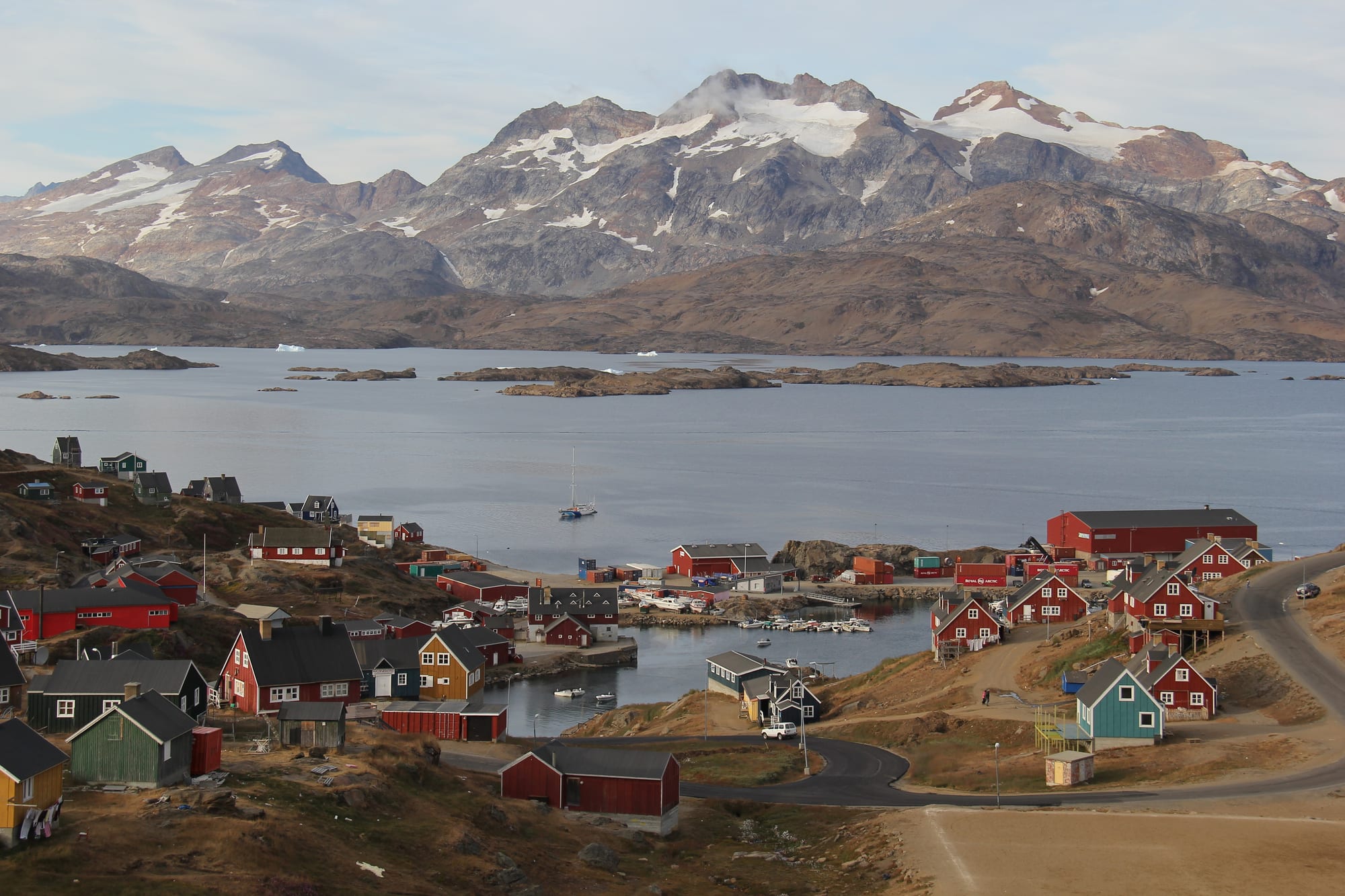
Red, green and yellow wooden houses around a small harbour, with a calm fjord and snow-streaked mountains behind

Greenland

Tasiilaq

Tasiilaq and its harbour on the Tasiilaq Fjord, with the mountains of Ammassalik Island beyond. (Helene Brochmann / Wikimedia Commons · CC BY-SA 4.0)

The largest community on Greenland's east coast, a town of about 2,000 people on a natural harbour of Ammassalik Island, ringed by mountains. Founded as a Danish trading station in 1894 among East Greenlandic Inuit who had only met Europeans a decade earlier, it is now a base for hiking, boat trips among the icebergs and helicopter flights to the glaciers.

Neighbourhoods

  • Town centre and harbour
    • First-time visitors
    • Boat trips
    • Museums

    The houses of the town climb the slopes around the natural harbour of Kong Oscars Havn. The grocery store, the bakery, the post office, the museum in the old church and a bar by the water are all within a short, hilly walk, and boat trips leave from the harbour.

    Open in Maps
  • The heliport and the edge of town
    • Hiking
    • Budget stays

    The heliport, with the campground across from it, sits at the edge of town, and from here walkers can simply head out onto Ammassalik Island. The short gravel road to the hydroelectric plant is the longest road in the area.

    Open in Maps

Things to do

In town

  • Ammassalik Museummuseum

    The town museum, housed in the old church of 1908, Tasiilaq's first.

    Open in Maps
  • Tasiilaq Churchlandmark

    The church built in the 1980s to replace the old one, with interior decoration by the Greenlandic artist Aka Høegh.

    Open in Maps

Ice, fjords and mountains

  • Iceberg boat tripsattraction

    Half-day and full-day boat tours among the icebergs that fill the waters around the town, some combined with a visit to an abandoned village.

    Open in Maps
  • Ammassalik Islandtrail

    The 772 km² island the town stands on, where hikes start straight from the edge of town into mountain country with no settlements; walkers should carry an emergency beacon.

    Open in Maps
  • Mittivakkat Glacierlandmark

    Part of the largest ice field on Ammassalik Island and the most studied glacier in Greenland not connected to the ice sheet; it has been retreating for most of the period since 1898.

    Open in Maps

Short trips from the town

  • Sermilikviewpoint

    A large fjord west of Ammassalik Island whose mouth lies about 15 km west of the town.

    Open in Maps
  • Ikkatteqattraction

    A small village abandoned in 2005, reached on boat tours that are usually combined with iceberg watching.

    Open in Maps
  • Kulusukattraction

    The airport settlement on the neighbouring island, with about 240 people, whose airport was built by the US military in 1956.

    Open in Maps
  • Tiilerilaaqattraction

    A small settlement of under a hundred people, formerly called Tiniteqilaaq, one of the villages served by helicopter from Tasiilaq.

    Open in Maps

Eat and drink

Long-standing places and food districts in Tasiilaq. Hours, ratings and directions come from your maps app, always current.

Tasiilaq classics

  • Pilersuisoqmarket

    The grocery store in the town centre and the base of most self-catering.

    Open in Maps
  • Bakery and sports-centre canteenneighborhood

    The town has a bakery, and the canteen in the sports centre serves fast food such as fried chicken and hot dogs.

    Open in Maps
  • Harbour barneighborhood

    A bar by the harbour, the town's main place for a drink.

    Open in Maps

Experience Tasiilaq

History

The first people to reach eastern Greenland were the Saqqaq, coming down from the far north, followed by the Dorset culture. The Norse knew the coast as the first landmark on the voyage from Iceland's Snæfellsnes peninsula, and Thule migrants passed through in the 15th century. Later the south-east was largely deserted for two centuries as people moved back to the more crowded west coast, and it was not settled again until the late 18th century.

In 1884–85 the Danish naval captain Gustav Holm led an expedition to the Ammassalik coast, the area's first contact with Europe. By the mid-1880s about 400 people lived there, facing vanishing resources, malnutrition and disease. A permanent Danish trading station followed in 1894 under the name Ammassalik, "the place with the ammassat", after the capelin, a small fish; the first church was built in 1908, and the station became a colony in 1925, when 84 of its Greenlandic residents were moved north to found Ittoqqortoormiit.

Until at least the 1920s families left town each summer for hunting and fishing camps in the fjords and mountains. From the end of the Second World War into the 1960s the town turned from hunting to cod fishing. On 6 February 1970 the worst piteraq ever recorded tore through and nearly ruined it. In 1997 it took the official name Tasiilaq, "the place at the lakes", the name local people had long used.

Culture & Customs

Tasiilaq is the heart of East Greenland and the main place where East Greenlandic, distinct from the west-coast language, is spoken. The East Greenlanders, the Tunumiit, are widely believed to have had no direct contact with Europeans before Holm's expedition. They are known for the Ammassalik wooden maps, carved wooden pieces that trace the shape of the coastline, which Holm's expedition brought back in the 1880s.

The Ammassalik Museum keeps the town's history in the old church of 1908. Its replacement, built in the 1980s, has interior decoration by the artist Aka Høegh. The kaffemik, an open house with coffee and cake for a birthday or other milestone, brings neighbours together.

Visitors find people polite and interested in outsiders, especially those who speak English. Hunting and fishing remain part of local identity. The town has also faced hard times: in September 2021 alcohol was banned for two weeks after a surge of violence and suicide, and reports of domestic violence fell sharply during the ban.

Daily Life

Tasiilaq had 1,985 inhabitants in 2020, making it the seventh-largest town in Greenland and by far the largest community on the east coast. It is one of the fastest-growing towns in the country: apart from Nuuk, it is the only town in Sermersooq municipality to have grown steadily over the last two decades.

Many residents still fish and hunt, but administration and services now employ a large share of the town. The town has a hospital, schools, a children's home, a sports hall, a police station, a post office and a bakery, and it is the hub for the helicopters that serve the villages of Isortoq, Kuummiut, Sermiligaaq and Tiilerilaaq.

Life is shaped by isolation. There are no roads beyond the town, and in summer cargo boats also link Tasiilaq with Kulusuk. Tourism is small — in 2005 the town saw several hundred visitors a year from Iceland — and summer brings ice-cave tours, glacier hikes, kayaking and whale watching. Scientists also come: the Sermilik research station nearby studies the Mittivakkat Glacier.

Food

Food in Tasiilaq follows the pattern of the Greenlandic coast: imported groceries from the Pilersuisoq store combined with fish and meat from local hunters and fishers. The town's old name recalls the ammassat, or capelin, a small fish, and cod has been the mainstay of the local fishery since the mid-20th century. Many residents still fish and hunt.

Suaasat, a soup of seal, whale or reindeer with rice or barley, is Greenland's national dish. For visitors, the choices are few: a hotel restaurant, the bakery, and the canteen in the sports centre with fried chicken, chips and hot dogs. Local people are the best guide to anything else.

Coffee is central to social life, served with cake at the kaffemik. A bar by the harbour is the town's main place for a drink, and prices for everything are high because almost all food arrives by sea or air. For parts of the year there is too much ice in the water for boats.

Planning tools

Budget

Tasiilaq is expensive, and so is reaching it: the helicopter from Kulusuk, guided boat trips and glacier flights are the big costs. Accommodation is costly too, though the campground, rented huts and stays with local families are cheaper options. Hiking from town is free.

Daily Budget Midrange
USD 290–580 (hotel, restaurant meals, one boat or helicopter excursion; flights extra)
Daily Budget Shoestring
USD 100–170 (campground or rented hut, supermarket food, hiking from town)

Budget separately for the transfer from Kulusuk Airport and for any helicopter tours; the hotels and campground can help arrange boats and stays.

Best Time to Visit

Summer is the season for ice-cave tours, glacier hikes, boat trips, whale watching and kayaking, when the town sees most of its visitors. Winters are long, cold and snowy, and piteraqs — violent winds off the ice sheet — strike from time to time.

Suggested Number of Days

Three or four days allow time for the town, a boat trip and a day's hiking. Allow a week or more for multi-day hikes on the island or visits to the outlying settlements. Weather can stop helicopters, so spare days are essential.

First Visit
3–4 days
With Surroundings
6–8 days

Transportation

There are no roads beyond the town; the longest is a narrow gravel road of about 3 km to the hydro power plant. The town is walked, with a taxi service for the hills. Settlements such as Kuummiut, Isortoq and Sermiligaaq are reached by helicopter from the heliport or by local boat.

Settlement helicopters and boats are infrequent and weather-dependent, so arrange them well ahead and keep the return flexible.

Airport & Station Connections

The nearest airport is Kulusuk Airport on the neighbouring island, linked by Icelandair to Reykjavík–Keflavík (since 2025 in summer only) and by Air Greenland to Nuuk, with arrivals timed for connections. From Kulusuk, Air Greenland helicopters fly to Tasiilaq Heliport; in summer boats also make the crossing, and some hotels collect guests by boat. The scheduled helicopters do not always meet demand.

Walkability

The town is small enough to cross on foot, but it is built on hills, so walking involves plenty of climbing. Hikes begin at the edge of town. Snow and ice cover the ground for much of the year.

Safety

Towns are safe, with little serious crime, though alcohol-related problems and, more privately, high rates of suicide and social distress are part of the picture. In September 2021 the self-rule authorities banned alcohol in Tasiilaq for two weeks after a surge of violence and suicide. For visitors the main dangers are the wilderness and the weather.

Hikes quickly leave all settlements behind: carry an emergency position-indicating radio beacon, make sure travel insurance covers search and rescue, and watch the forecast for piteraq winds. Check current official travel advice before travelling.

Climate

A tundra climate with long, cold, snowy winters and short, cool, drier summers. The town is sometimes hit by the piteraq, a fierce wind off the ice sheet; the worst on record, on 6 February 1970, nearly wrecked it.

Summer
short and cool — on Greenland's ice-free coast summer days are roughly 5–15°C
Winter
long, cold and snowy, with occasional piteraq storms — at neighbouring Kulusuk average winter temperatures are often in single digits below 0°C, though the wind makes it feel far colder

Local Customs

East Greenlandic, distinct from the Greenlandic of the west coast, is spoken here more than anywhere else, and Danish is widely understood. Hunting and fishing remain part of life, and furs are sold as souvenirs. People are courteous and curious about visitors, and the kaffemik, an open house with coffee and cake, is the main social custom.

Ask before photographing people and their catches, and ask locally for help — residents are generally glad to point visitors to food, boats and lodging.

Common Payment Methods

The currency is the Danish krone. Cards are accepted in Greenland's towns, but carry cash for boat trips with local fishermen and the outlying settlements, where facilities are minimal.