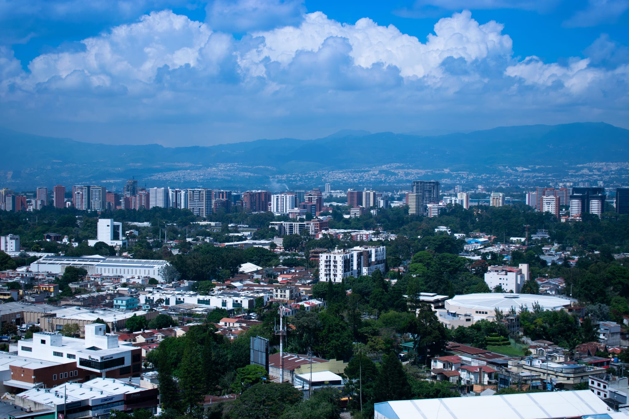
Clusters of high-rise towers among green trees and low buildings, with blue mountains and towering white clouds behind

Guatemala City & Antigua, Guatemala

Guatemala City

High-rise towers in the southern zones of Guatemala City, with the mountains of the valley beyond. (Juan Francisco / Wikimedia Commons · CC BY-SA 2.0)

The capital of Guatemala and the largest metropolitan area in Central America, spread across the Valle de la Ermita in the central highlands over the buried Maya city of Kaminaljuyu. Founded after the 1773 earthquakes ruined Antigua and rebuilt after the quakes of 1917–18 and 1976, it is a city of numbered zones, from the historic centre to the towers of Zona 10.

Neighbourhoods

  • Zona 1 — the historic centre
    • Historic district
    • Architecture

    The old heart of the city around the Plaza de la Constitución, with the National Palace, the Metropolitan Cathedral, Congress and colonial churches. The pedestrianised Paseo de la Sexta has revived its nightlife, but parts of the zone are rough, especially after dark.

    Open in Maps
  • Zona 4 and Cuatro Grados Norte
    • Arts and culture
    • Nightlife
    • Best for food

    South of the centre, home to the Centro Cívico, the national theatre and the tourist board. Cuatro Grados Norte, a district of pedestrian streets created in the 2000s, has bars, restaurants, shops and cultural events.

    Open in Maps
  • Zona 10 and Zona Viva
    • First-time visitors
    • Nightlife
    • Museums

    The business district east of Avenida La Reforma, with most of the upmarket hotels, restaurants, bars and shopping centres. Zona Viva, its nightlife quarter, is one of the places considered safe to go out after dark, and the Popol Vuh and Ixchel museums are on a university campus here.

    Open in Maps
  • Zona 13 — La Aurora
    • Close to the airport
    • Museums
    • Parks

    The southern zone around La Aurora International Airport, with the zoo, the national archaeology museum and other museums in the former Finca La Aurora, a convenient base for early flights.

    Open in Maps

Things to do

Famous landmarks

  • National Palace of Culturelandmark

    The palace built in 1939–43 as the president's headquarters, known as the 'Palacio Verde'; the country's roads are measured from a point inside it.

    Open in Maps
  • Metropolitan Cathedrallandmark

    The great neoclassical cathedral facing the main square, built mostly between 1782 and 1815, its towers finished in 1867, seat of the Archdiocese of Guatemala.

    Open in Maps
  • Torre del Reformadorlandmark

    A 72-metre steel tower in Zona 9 shaped like the Eiffel Tower, built in 1935 for the centenary of the birth of President Justo Rufino Barrios.

    Open in Maps
  • Centro Cultural Miguel Ángel Asturiaslandmark

    The national theatre complex in the Centro Cívico, named after the Nobel laureate and shaped to suggest a seated jaguar, on the site of an old fort.

    Open in Maps

Museums

  • Museo Popol Vuhmuseum

    One of the major collections of Maya art in the world, best known for its painted funerary ceramics and Preclassic stone sculpture, on the Universidad Francisco Marroquín campus.

    Open in Maps
  • Ixchel Museum of Indigenous Textiles and Clothingmuseum

    A museum of Guatemala's traditions of dress, with collections of textiles, ceramics and jewellery, on the same university campus as the Popol Vuh museum.

    Open in Maps
  • Museo Nacional de Arqueología y Etnologíamuseum

    The national museum of archaeology and ethnology at Finca La Aurora, dedicated to conserving the country's archaeological and ethnological heritage.

    Open in Maps
  • Relief Map of Guatemalaattraction

    A huge relief map of the country laid out at ground level over about 1,800 square metres, so large it is seen from viewing towers.

    Open in Maps

Archaeology and parks

  • Kaminaljuyuattraction

    The Maya city occupied from about 1500 BC to AD 1200, once some 200 platforms and mounds; most of it lies under the city, but part of the centre survives as a small park.

    Open in Maps
  • La Aurora Zoopark

    A zoo founded in 1924, one of the largest urban green spaces in the city, with areas for animals from Asia, the Americas and Africa.

    Open in Maps

Streets and nights out

  • Paseo de la Sextaneighborhood

    The Sixth Avenue of Zona 1, the old main shopping street, revived as a pedestrian promenade in the mid-2000s, which brought nightlife back to the historic centre.

    Open in Maps
  • Cuatro Grados Norteneighborhood

    A cultural district of pedestrian streets in Zona 4, opened in 2002, with bars, restaurants, shops and events.

    Open in Maps

Short trips from the city

  • Pacayatrail

    An active volcano about 30 kilometres south-west of the city, climbed on guided walks across lava fields; its 2010 eruption killed a reporter and forced about 2,000 people to evacuate.

    Open in Maps
  • Antigua Guatemalaattraction

    The colonial capital before 1776, a UNESCO World Heritage Site of Baroque churches and ruined convents beneath the Volcán de Agua.

    Open in Maps

Seasonal events

  • Independence Day15 September

    The anniversary of the 1821 Act of Independence of Central America, signed in the city and now Guatemala's national day.

Eat and drink

Long-standing places and food districts in Guatemala City. Hours, ratings and directions come from your maps app, always current.

Guatemala City classics

  • Shuco cartsneighborhood

    The capital's street hot dog, piled with guacamole, cabbage and sauces, sold from carts across the city — including a well-known cluster between the Estadio del Ejército and Campo Marte in Zona 5.

    Open in Maps
  • Pollo Camperorestaurant

    The fried-chicken chain founded in Guatemala in 1971, part of a Guatemalan family-owned group.

    Open in Maps

Food districts and markets

  • Mercado Centralmarket

    The city's central market in the historic centre, the place to see the capital shop for produce and everyday goods.

    Open in Maps
  • Zona Vivaneighborhood

    The densest choice of restaurants and bars in the city, from steakhouses to international kitchens, in the nightlife quarter of Zona 10.

    Open in Maps
  • Cuatro Grados Norteneighborhood

    Bars and restaurants along the pedestrian streets of the Zona 4 cultural district.

    Open in Maps

Experience Guatemala City

History

People settled the Valle de la Ermita long before the Spanish. Kaminaljuyu, a Maya city occupied from about 1500 BC to AD 1200, grew into one of the great centres of the highlands, with some 200 platforms and pyramidal mounds; it declined in the Late Classic period and collapsed amid drought and political instability. In the early colonial era the valley held only a small town around the monastery of El Carmen, founded in 1620.

Its fate changed with the Santa Marta earthquakes of 1773, which ruined the capital at Antigua. In 1776 the seat of government moved to this valley, thought less prone to earthquakes, and the new city — Nueva Guatemala de la Asunción — was laid out around a central plaza and the neoclassical Metropolitan Cathedral, built mostly between 1782 and 1815. In September 1821 the Act of Independence of Central America was signed here.

The valley proved no safer. The earthquakes of 1917–18 almost destroyed the city, and the slums that grew afterwards spread without water, sewers or paved roads. The National Palace, the president's headquarters, was built in 1939–43. The 1976 earthquake on the Motagua Fault struck again, and mass migration from impoverished, politically unstable rural districts followed, making the metropolitan area the largest in Central America. In May 2010 the eruption of Pacaya and the rains of Tropical Storm Agatha struck within days of each other, and the storm opened a sinkhole in Zona 2.

Culture & Customs

The capital is the centre of Guatemala's institutions and much of its cultural life. The Universidad de San Carlos, founded in 1676, is the oldest and largest university in Guatemala, and the Centro Cultural Miguel Ángel Asturias, named after the Nobel-winning novelist, holds the national theatre. Collections of Maya and pre-Columbian art fill the Popol Vuh and national archaeology museums, while the Ixchel museum documents the dress of Maya communities across the country.

Most residents are of Spanish or Mestizo descent, and Spanish is the everyday language, but decades of mass migration from the countryside have brought people from across Guatemala. On Sundays crowds fill the main plaza in Zona 1 for music, art and food.

Football is the most popular sport. Municipal and Comunicaciones are the main clubs, and the Estadio Doroteo Guamuch Flores in Zona 5 is the largest stadium in the country. Independence Day on 15 September is the national day. Since the 2000s the revival of the historic centre and the Cuatro Grados Norte district has given the city new places to go out, alongside the long-established nightlife of Zona Viva.

Daily Life

The 2018 census counted about 923,000 people in the municipality of Guatemala City, and the national statistics institute estimated the metropolitan area, which takes in neighbouring municipalities such as Mixco and Villa Nueva, at about 5.1 million that year. The city is the country's economic heart and its main transport hub, home to banks, company headquarters, the airport and the start of most of the major highways.

The zones divide sharply. Towers of offices and flats rise in Zonas 10 and 14, where height limits set by the airport cap them at 60 metres in Zona 10, while hillside settlements cling to the ravines that cut through the valley. Rapid growth since the 1970s has strained the city's infrastructure, and crime is a long-running problem.

Daily life runs on the Transmetro, buses and private cars, comedor lunches and weekend trips to Antigua or the Pacific coast. The rainy season brings flash floods and mudslides, and sinkholes have opened in the city's soft volcanic ground. In January 2026 gang attacks that followed prison riots killed ten police officers and led to a 30-day state of emergency.

Food

The capital eats the national table: tortillas, black beans, fresh cheese and cream, tamales, especially around Christmas, and stews such as pepián, thickened with seeds and chillies. Guatemalan tamales are usually wrapped in plantain or banana leaves rather than corn husks. Its own street food is the shuco, a hot dog piled with guacamole, cabbage and sauces and sold from carts across the city, with a well-known cluster between the Estadio del Ejército and Campo Marte in Zona 5.

Pollo Campero is the fried-chicken chain founded in Guatemala in 1971, and Gallo beer comes from a brewery based in the capital. The Mercado Central in Zona 1 is the historic market, and comedores across the city serve set lunches.

For eating out, Zona 10's Zona Viva has the widest choice of restaurants, from steakhouses to international kitchens, while Cuatro Grados Norte in Zona 4 and the revived Paseo de la Sexta mix bars, cafés and casual restaurants.

Planning tools

Budget

The business districts of Zonas 10 and 4 are expensive by Guatemalan standards, with international hotels and restaurants priced accordingly. Street food, comedores and markets are cheap, and metered or app taxis cost far less than in North America. Most visitors spend a night or two here and save their budget for Antigua and the lake.

Daily Budget Midrange
USD 90–170 (Zona 10 hotel, restaurants, museum entries, taxis)
Daily Budget Shoestring
USD 35–50 (hostel near the airport, comedor meals and shucos, Transmetro and app taxis)

Pay a little more to stay in Zona 10, 13 or 14 rather than in the cheapest parts of the centre, and use taxis or ride-hailing rather than walking between zones.

Best Time to Visit

The dry season from November to April brings clear skies and the clearest volcano views; the wet season from May to October brings afternoon storms and occasional flooding.

Suggested Number of Days

Most visitors give the capital a day or two around a flight, which is enough for the historic centre and the main museums. Allow three or four to add the volcano walks and nearby towns, though most people choose to sleep in Antigua instead.

First Visit
1–2 days
With Surroundings
3–4 days

Transportation

The city is divided into numbered zones, each with its own grid of calles and avenidas, so an address always needs its zone. The Transmetro bus rapid transit, running since 2007 partly in dedicated lanes, has stops and buses guarded by municipal police and is paid with a prepaid card. The old red city buses suffer violent robbery and extortion and are best avoided. Yellow metered taxis log every trip, and Uber operates in the city.

Use ride-hailing, yellow metered taxis or a driver recommended by a hotel; avoid unlicensed white taxis and the red city buses.

Airport & Station Connections

La Aurora International Airport, the country's main air hub, is in Zona 13, about 6 kilometres south of the centre and 25 kilometres from Antigua. Taxis wait outside, and tourist shuttles connect to Antigua and Lake Atitlán. Long-distance and international buses use their own company terminals and the Centra Norte and Centra Sur terminals on the edges of the city.

Walkability

Within a zone, walking is possible: the Paseo de la Sexta and the main square in Zona 1 are pedestrian, and Zona 10 and Cuatro Grados Norte can be covered on foot by day. Between zones the distances, ravines, busy roads and crime make taxis the sensible choice, especially after dark.

Safety

Guatemala has significant crime, including gang activity and armed robbery, concentrated in parts of Guatemala City and on some highways and rural routes. Parts of the city suffer gang violence, extortion and armed robbery, and some highways through the metropolitan area see hold-ups. Zona Viva in Zona 10, Zona 14 and Cuatro Grados Norte are the areas generally considered safe for going out at night.

Avoid Guatemala City's Zonas 1, 3 and 18 and travel after dark, keep valuables out of sight, and use registered taxis or ride-hailing apps rather than hailing cars on the street. Check current official travel advice before travelling.

Climate

At 1,500–1,700 metres in the Valle de la Ermita the capital has a mild climate, with average temperatures between about 10 and 25°C. The wet season brings partly sunny mornings and afternoon rain or storms; the coolest weather comes in January and February, and the warmest days, sometimes above 30°C, come at the end of the dry season.

Summer
wet season: roughly 16–28°C, with sunny mornings and afternoon storms
Winter
dry season: cooler and windier from late December to March; January and February are the coldest months, with record lows of about 2°C

Local Customs

The capital is Spanish-speaking, and most residents are of Spanish or Mestizo descent, with many who have moved in from rural areas. Addresses follow the zone system, each zone having its own numbered calles and avenidas. Football is followed closely, with Municipal and Comunicaciones the leading clubs.

Dress modestly in churches, ask before photographing people, and keep phones and cameras out of sight on the street.

Common Payment Methods

The currency is the Guatemalan quetzal (Q). Cards are widely accepted in Zona 10, shopping centres and hotels, and US dollars are taken by some hotels and tour operators, but cash is needed for markets, street food and buses. Use ATMs inside banks or shopping centres.