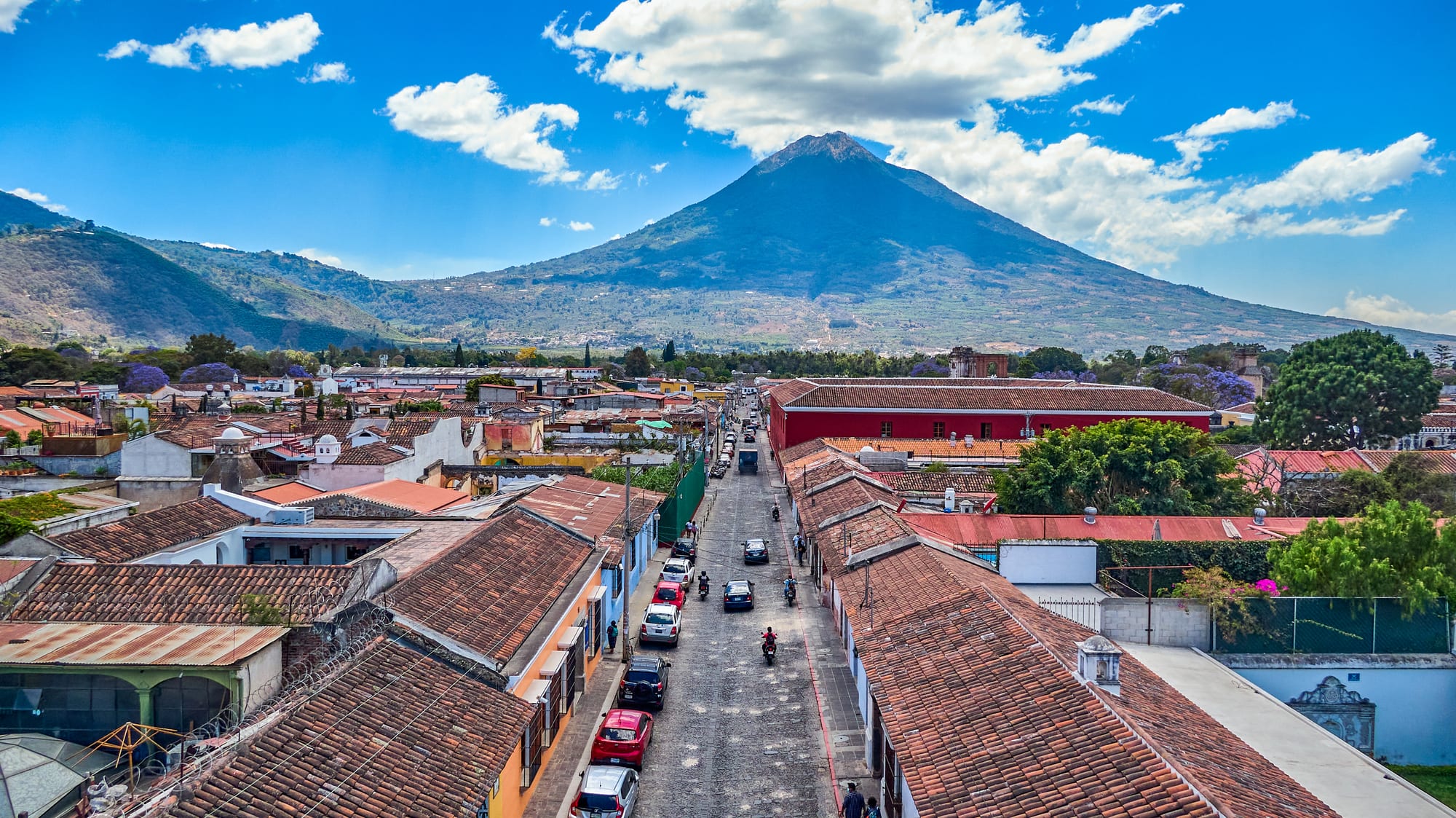
Aerial view of Antigua's tiled rooftops and a straight cobbled street leading towards the green cone of a large volcano

Guatemala

Guatemala City & Antigua

Antigua Guatemala from the air, with the Volcán de Agua rising behind the colonial city. (Juan Francisco / Wikimedia Commons · CC BY-SA 2.0)

The central highlands and the slope down to the Pacific, taking in the sprawling capital, the colonial city of Antigua beneath its volcanoes, the Kaqchikel Maya towns of Chimaltenango and the hot sugar-cane lowlands of Escuintla — the country's political, economic and tourist core.

Explore Guatemala City & Antigua

History

Long before the Spanish, the valley of Guatemala City held Kaminaljuyú, a large Maya city that flourished in the Preclassic and Classic periods and traded with distant Teotihuacan; much of it now lies beneath the western part of the capital. In the lowlands of Escuintla, the Cotzumalguapa culture carved great stone sculptures around Santa Lucía Cotzumalguapa. By the 15th century the highlands were divided among Maya kingdoms, and the Kaqchikel ruled from Iximché.

The Kaqchikel first allied with Pedro de Alvarado, and in 1524 the Spanish founded their first capital beside Iximché, but tribute demands soon turned the alliance into a long revolt. The capital moved to Ciudad Vieja, which a mudflow from the Volcán de Agua destroyed in 1541, and then to the Panchoy valley, where Santiago de los Caballeros, now Antigua, governed Central America for more than two centuries. After the Santa Marta earthquakes of 1773 the Crown ordered the capital moved again, to the Valle de la Ermita, where Nueva Guatemala de la Asunción became today's Guatemala City.

The capital grew into the country's centre of power and industry, and was badly damaged by earthquakes in 1917–18 and again in 1976, when the quake hit Chimaltenango especially hard. During the civil war the city saw political assassinations and the burning of the Spanish embassy in 1980, while army operations and massacres struck Maya villages in the highlands. In 2018 an eruption of Fuego sent pyroclastic flows through communities in Escuintla, leaving hundreds dead or missing.

Culture & Customs

The region mixes Ladino and Maya worlds. Guatemala City and Escuintla are largely Spanish-speaking and Ladino, while Chimaltenango and the villages of Sacatepéquez are Kaqchikel country, where many women still wear huipiles whose patterns identify their town. San Antonio Aguas Calientes, near Antigua, is known for its fine backstrap weaving, and San Juan Comalapa for a school of naive painting that records village life and memory.

Antigua's Holy Week is famous across the Americas: brotherhoods carry huge wooden platforms bearing images of Christ and the Virgin through the streets, over alfombras, carpets of coloured sawdust, flowers and pine needles that families spend the night making and that are trampled within minutes. On 1 November Sumpango and Santiago Sacatepéquez fly barriletes gigantes, giant tissue-paper kites several metres across, at or near their cemeteries to honour the dead.

Antigua is also the resting place of Hermano Pedro de San José de Betancur, a Franciscan tertiary from the Canary Islands who cared for the city's poor and was canonised in 2002; his tomb in the church of San Francisco draws steady pilgrims. San Andrés Itzapa, in Chimaltenango, has a shrine to San Simón, the folk saint also known as Maximón. The marimba, Guatemala's national instrument, plays at fiestas across the region.

Daily Life

Greater Guatemala City, home to roughly three million people across the capital and neighbouring municipalities such as Mixco and Villa Nueva, dominates national life. Its gridded zones divide sharply: the business towers and restaurants of Zona 10 and the regenerated Zona 4 sit a short drive from crowded markets and hillside settlements on the ravines. Traffic is heavy, and many residents spend hours each day commuting.

Antigua, with some 45,000 people in its municipality, lives from tourism, Spanish schools and weddings, as well as the coffee grown on the surrounding slopes, one of the country's named coffee regions. Rising property prices have pushed many local families out of the historic centre into nearby villages such as Jocotenango and Ciudad Vieja. Chimaltenango is a busy market town on the Pan-American Highway, surrounded by farmland producing vegetables.

Escuintla is sugar country, with cane fields and mills across the Pacific plain, and cattle ranches. Puerto Quetzal, on the coast, is Guatemala's main Pacific port. In the lowlands life starts early to beat the heat, while in the highlands the day follows the market and the comedor lunch.

Food

The region's cooking is the national table at its most complete. Pepián, a stew thickened with seeds and made with chicken or beef, is a dish of Kaqchikel and colonial roots, and tamales colorados, red with tomato and achiote and wrapped in plantain leaves, are eaten especially around Christmas. On 1 November families prepare fiambre, a huge cold salad of cured meats, sausages, cheeses and pickled vegetables that can run to dozens of ingredients.

Antigua's coffee is among Guatemala's most prized, grown on volcanic soils at altitude.

Guatemala City has its own street food: shucos, hot dogs piled with guacamole, cabbage and sauces, sold from carts across the capital, and the chicken chain Pollo Campero began in Guatemala in 1971. Gallo, the national beer, is brewed in the capital. On the Pacific coast the food turns to seafood, with fried fish and seafood soups served in beach comedores at Puerto San José and Iztapa.

Attractions & Natural Wonders

Antigua is the centrepiece: the Arco de Santa Catalina framing the Volcán de Agua, the façade of La Merced, the ruined cathedral and the convents of Las Capuchinas and Santa Clara, the Palacio de los Capitanes Generales on the Parque Central, and the view over the town from Cerro de la Cruz. Nearby Ciudad Vieja and San Antonio Aguas Calientes make short excursions.

Antigua's volcanoes shape every view. Agua rises to the south, and to the west stand Acatenango and Fuego. The Acatenango hike, a steep overnight climb to camps high on the volcano, rewards walkers with night-time views of Fuego throwing out lava. Pacaya, south of the capital, is a shorter walk over lava fields.

Guatemala City has the Palacio Nacional and the Metropolitan Cathedral on the Plaza de la Constitución, the Mercado Central, and the Museo Nacional de Arqueología y Etnología, the Popol Vuh museum of Maya art and the Ixchel museum of textiles. The Mapa en Relieve, a giant relief map of the country built in 1905, and the mounds of Kaminaljuyú are further draws. West, the Kaqchikel ruins of Iximché stand near Tecpán.

On the Pacific side, the Cotzumalguapa sculptures lie around Santa Lucía Cotzumalguapa, and black-sand beaches line the coast at Puerto San José and Iztapa.

Cities in Guatemala City & Antigua

Planning basics

Budget

This is the most expensive part of Guatemala. Antigua's boutique hotels, restaurants, Spanish schools and tour agencies charge well above the national average, and Guatemala City's business districts in Zonas 10 and 4 are pricier still. Chimaltenango's market towns and the Escuintla lowlands cost far less, and simple hostels and comedores in Antigua keep a tight budget workable.

Daily Budget Midrange
USD 80–160 (courtyard hotel in Antigua, restaurants, a guided volcano hike)
Daily Budget Shoestring
USD 35–50 (hostel dorm, comedor meals, shared shuttles)

The Acatenango trek and Spanish lessons are the biggest costs; compare several agencies in Antigua and check what the price includes.

Safety

The region holds both the country's worst urban crime and its calmest tourist town. Parts of Guatemala City suffer gang violence, extortion and armed robbery, and some highways through the metropolitan area and Escuintla see hold-ups. Antigua is well policed but has bag-snatching and occasional robberies on its outskirts. Fuego is one of the most active volcanoes in Central America, and Acatenango is a hard, cold climb.

Avoid the capital's high-crime zones and travel after dark, climb volcanoes only with registered guides, follow volcanic activity alerts, and watch for rip currents on the Pacific beaches. Check current official travel advice before travelling.

Climate

Guatemala City and Antigua lie at around 1,500 metres and are mild all year, with warm days and cool nights; the higher Chimaltenango plateau is colder. Below the volcanoes, Escuintla and the Pacific coast are hot and humid. The wet season from May to October brings afternoon storms, and the summit of Acatenango can drop below freezing at night.

Summer
wet season: 18–26°C in the highlands with afternoon downpours; 30–35°C and humid on the coast
Winter
dry season: sunny and 20–27°C by day in Antigua, nights down to around 10°C; freezing on the volcano summits

Transportation

La Aurora International Airport in Guatemala City is the country's main gateway, and Antigua is roughly an hour away by road, longer in the capital's heavy traffic. Tourist shuttles link the airport, Antigua, Lake Atitlán and the coast; chicken buses run between Antigua, Chimaltenango and the capital. The Pacific Highway crosses Escuintla.

Allow extra time for traffic in and out of Guatemala City, and use registered taxis or ride-hailing apps rather than hailing cars on the street.

Best Time to Visit

November to April brings dry weather and the clearest volcano views, the best conditions for Acatenango. Antigua's Holy Week processions in March or April are the region's great spectacle but fill every bed and raise prices. The kite festivals at Sumpango and Santiago Sacatepéquez fall on 1 November. The wet season is green and quieter, with most rain in the afternoon.