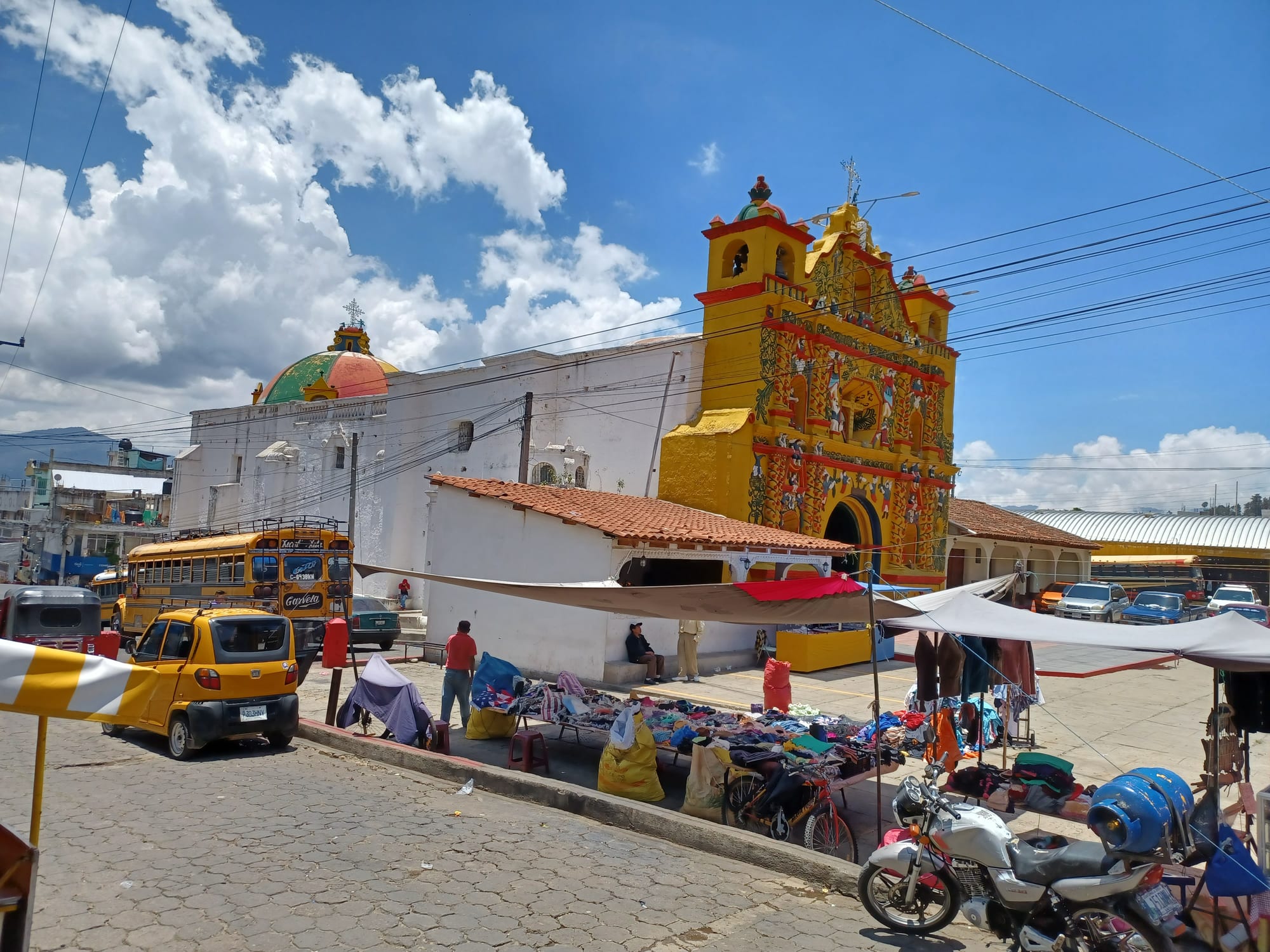
A bright yellow church facade covered in coloured figures beside a white nave with a tiled dome, with market stalls and a yellow bus in front

Guatemala

Lake Atitlán & the Western Highlands

The 17th-century church of San Andrés Xecul in Totonicapán department. (Simon Burchell / Wikimedia Commons · CC BY-SA 4.0)

The Maya heartland of western Guatemala, running from Lake Atitlán and Chichicastenango up to Quetzaltenango, the Cuchumatanes and the Mexican border, then down to the hot Pacific lowlands — a region of K'iche', Mam, Tz'utujil and Ixil towns, market days and high volcanoes.

Explore Lake Atitlán & the Western Highlands

History

The highlands were home to powerful Maya kingdoms by the 15th century: the K'iche' ruled from Q'umarkaj, near today's Santa Cruz del Quiché, while the Kaqchikel, Tz'utujil and Mam held their own territories around Lake Atitlán and in the west, where the Mam capital was Zaculeu. On the Pacific slope, much older sites such as Tak'alik Ab'aj show links between Olmec and early Maya culture.

In 1524 Pedro de Alvarado defeated the K'iche' in battles near Xelajú, now Quetzaltenango, where tradition places the death of the K'iche' leader Tecún Umán, today a national hero, and then burned Q'umarkaj. The Spanish resettled the highland Maya into new towns, and in Chichicastenango the friar Francisco Ximénez copied the Popol Vuh, the K'iche' book of creation, in the early 18th century. In 1838 Quetzaltenango led a short-lived breakaway State of Los Altos, reabsorbed by Guatemala in 1840. Coffee transformed the Pacific slopes in the late 19th century, drawing highland Maya to the plantations as seasonal labourers, and in 1902 Santa María volcano erupted violently near Xela.

The civil war fell hardest here. In the early 1980s the army's counter-insurgency campaign destroyed hundreds of villages in Quiché and Huehuetenango and drove many into exile in Mexico. The UN-backed truth commission later found that the state committed acts of genocide, and the Ixil Maya of Nebaj, Chajul and Cotzal became the focus of the legal case: in 2013 a Guatemalan court convicted former head of state Efraín Ríos Montt of genocide against the Ixil, a verdict annulled days later, and in 2018 a court found that genocide had been committed against the Ixil. Rigoberta Menchú, a K'iche' woman from Uspantán, won the Nobel Peace Prize in 1992.

Culture & Customs

This is Guatemala's most Maya region. K'iche' is spoken across Quiché, Totonicapán and much of Quetzaltenango; Mam in San Marcos, Huehuetenango and western Quetzaltenango; Tz'utujil and Kaqchikel around the lake; and Ixil, Q'anjob'al, Chuj and other languages in the northern mountains. Dress marks each town, and in Todos Santos the traditional costume is still worn by the whole community.

Religion mixes Catholicism, evangelical Protestantism and Maya practice. In Chichicastenango, prayer-makers burn incense and copal on the steps of the church of Santo Tomás and at the hilltop shrine of Pascual Abaj, and cofradías, religious brotherhoods, guard the saints. Santiago Atitlán keeps Maximón, a cigar-smoking folk saint housed by a different cofradía member each year, and Zunil keeps its own San Simón. Momostenango is known for its woollen blankets.

The festivals are spectacular: the palo volador, in which men swing from a tall pole, at Chichicastenango's Santo Tomás fiesta in December; the horse race of Todos Santos on 1 November; and Holy Week in Santiago Atitlán. Totonicapán's 48 Cantones, a K'iche' communal authority, still manage local natural resources.

Daily Life

Quetzaltenango, usually called Xela, is the second-largest city in Guatemala, with some 180,000 people in its municipality, a university and neighbourhoods of grey stone buildings from the coffee era. Huehuetenango, Santa Cruz del Quiché, Totonicapán, San Marcos, Sololá and, on the coast, Mazatenango and Retalhuleu are the department capitals, but most people live in small towns and villages.

Farming dominates: maize and beans on steep plots, vegetables around Almolonga and Zunil for markets in Guatemala and El Salvador, and coffee in Huehuetenango and on the Pacific slope. The lowlands of Suchitepéquez and Retalhuleu grow sugar cane and other crops and raise cattle. Emigration to the United States is heavy, and remittances pay for the concrete houses rising in many villages.

The week turns on market days, when traders arrive before dawn with goods carried on buses and on their backs. Tourism drives the lake villages, especially Panajachel and San Pedro La Laguna, and Xela's Spanish schools draw long-staying students. Rural poverty and child malnutrition remain high.

Food

Highland food is maize-based and simple: tortillas at every meal, black beans, eggs, fresh cheese, chillies and herbs gathered from the fields. Tamales and chuchitos are steamed in maize husks or leaves, and pepián, the seed-thickened stew, is cooked for fiestas. Boxbol, maize dough wrapped in leaves and served with ground pumpkin seeds, is a traditional dish of the Ixil towns.

Markets sell atol, hot maize drinks, often sweetened, and pan dulce. Quetzaltenango has its own bakeries and sweet breads, and nearby Salcajá is known for caldo de frutas, a fruit liqueur, and rompopo, an eggnog-like drink. Huehuetenango grows coffee on its warmer slopes. On the Pacific coast the food changes to seafood and tropical fruit, with fish and shrimp at Champerico.

Rum and aguardiente, cheap cane spirit, are widely drunk. At the Maximón shrines offerings of liquor and cigars sit beside the candles.

Attractions & Natural Wonders

Lake Atitlán fills a volcanic caldera beneath the cones of San Pedro, Tolimán and Atitlán. Panajachel is the busy gateway; Santiago Atitlán, the largest town, has its colonial church and Maximón; San Pedro La Laguna draws backpackers; San Marcos La Laguna has yoga and meditation retreats; San Juan La Laguna has weaving and natural-dye cooperatives; and Santa Catarina Palopó has painted houses.

Chichicastenango's market, on Thursdays and Sundays, fills the streets around Santo Tomás with textiles, masks and produce. Nearby are the ruins of Q'umarkaj and, further north, the Ixil towns of Nebaj and Chajul, a base for hiking.

Quetzaltenango has a grand central square, the Parque Centroamérica, and makes a base for the Fuentes Georginas hot springs near Zunil, the crater lake of Laguna Chicabal, sacred to the Mam, and climbs of Santa María with views of the active Santiaguito dome. In San Marcos, Tajumulco is the highest mountain in Central America.

Huehuetenango has the restored Mam ruins of Zaculeu. Above it rise the Cuchumatanes, the highest non-volcanic range in Central America, with the town of Todos Santos Cuchumatán and walking over the high plateau.

In the Pacific lowlands, Tak'alik Ab'aj near El Asintal has carved monuments among coffee farms, Retalhuleu has the popular Xocomil and Xetulul theme parks, and Champerico has a long beach.

Cities in Lake Atitlán & the Western Highlands

Planning basics

Budget

The western highlands are cheaper than Antigua. Guesthouses in Quetzaltenango, Huehuetenango and the lakeside villages are good value, Spanish schools in Xela usually include a homestay, and boats and chicken buses cost little. Panajachel and the upmarket lodges on the lake shore are the exception, and the Pacific lowlands have few tourist services outside the Retalhuleu theme parks.

Daily Budget Midrange
USD 60–120 (lakeside hotel, restaurants, shuttles and a guided hike)
Daily Budget Shoestring
USD 25–40 (guesthouse or homestay, comedor meals, public lanchas and chicken buses)

Carry small notes for boats, market stalls and village entry fees; cash machines are scarce outside Panajachel, Xela and the department capitals.

Safety

The tourist circuit around the lake, Chichicastenango and Xela is generally calm, but robberies have occurred on some trails between the lake villages and on volcano and sunrise hikes. Border areas of Huehuetenango and San Marcos are used by drug and migrant smugglers, long-running land disputes between neighbouring municipalities in San Marcos have turned violent, and rumours can lead to mob violence in remote villages. Mountain roads are steep and driven fast.

Hike with local guides, ask before photographing people and especially children, avoid travelling at night on rural roads, and watch for landslides in the wet season. Check current official travel advice before travelling.

Climate

Altitude rules. Lake Atitlán, at about 1,560 metres, is mild all year; Quetzaltenango, higher at about 2,300 metres, has cold nights, with occasional frost in the dry season; the Cuchumatanes plateau and Tajumulco are colder still. The Pacific lowlands of Suchitepéquez and Retalhuleu are hot and humid. On the lake an afternoon wind, the Xocomil, raises choppy waves.

Summer
wet season: 15–24°C in the highlands with afternoon rain; 30–35°C and humid in the lowlands
Winter
dry season: sunny days around 20–25°C, cold nights near freezing in Xela and on the high plateau

Transportation

Tourist shuttles link Antigua and Guatemala City with Panajachel, Chichicastenango and Quetzaltenango, a few hours each, and chicken buses run the Pan-American Highway and its branch roads. Lanchas cross Lake Atitlán between Panajachel, San Pedro, San Marcos and Santiago. Minibuses climb from Huehuetenango into the Cuchumatanes and to Todos Santos, and the Pacific Highway runs through Mazatenango and Retalhuleu to the Mexican border.

Cross the lake in the morning, before the afternoon wind makes the water rough.

Best Time to Visit

November to April is dry and clear, the best time for volcano climbs and lake views. The 1 November celebrations in Todos Santos, the Santo Tomás fiesta in Chichicastenango in December and Holy Week in Santiago Atitlán are the great festivals. The wet season is green and quieter, but mountain roads can suffer landslides.