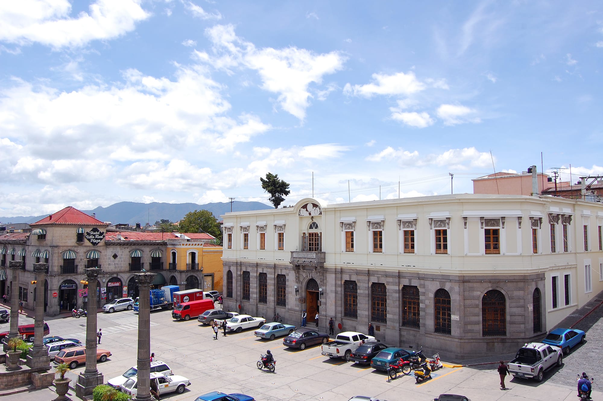
Grey-stone and cream colonial buildings on a corner of the central square, with stone columns in front and mountains behind

Lake Atitlán & the Western Highlands, Guatemala

Quetzaltenango

Buildings on the edge of the Parque Central in Quetzaltenango's historic centre. (Akr9091 / Wikimedia Commons · CC0)

Guatemala's second city, widely called Xela after its K'iche' name Xelajú, set in a volcanic basin 2,330 metres up in the western highlands. Coffee wealth and Italian builders gave it a grey-stone neoclassical centre after the 1902 Santa María eruption; today it is the region's hub for trade, universities and Spanish schools, and a base for volcanoes, hot springs and Maya towns.

Neighbourhoods

  • Zona 1 and the historic centre
    • First-time visitors
    • Historic district
    • Nightlife

    The old centre around the Parque Centroamérica, with the cathedral, the municipal palace, the Pasaje Enríquez and the Municipal Theatre in grey stone. Most guesthouses, cafés, restaurants and bars are within a few blocks, and the city's nightlife is concentrated here.

    Open in Maps
  • Barrio Las Flores
    • Language students
    • Quiet and residential

    A residential part of Zona 1 where many of the city's Spanish schools are found. Students live in homestays and guesthouses nearby, within walking distance of the central park.

    Open in Maps
  • Zona 3 and La Democracia
    • Markets
    • Local life
    • Close to public transport

    One of the districts the city spread into after the 1902 eruption, now its busy commercial centre. The covered La Democracia market and the streets around it sell produce at cheaper prices than the shops, and the Parque Benito Juárez and the San Nicolás church stand on its north side.

    Open in Maps
  • The Minerva terminal area
    • Close to public transport
    • Shopping

    The north-western side of the city around the Minerva bus terminal, where chicken buses leave for Guatemala City, the lake and the villages, with shopping malls and supermarkets close by.

    Open in Maps

Things to do

The historic centre

  • Parque Centroaméricapark

    The central square of the old town, laid out in its present form by Italian builders after 1902, ringed by neoclassical buildings and used for cultural events and the monthly artisans' market.

    Open in Maps
  • Quetzaltenango Cathedrallandmark

    The Holy Spirit Cathedral on the east side of the park, one of the city's first churches, keeping its old façade in front of a later building and holding two of the region's most revered images.

    Open in Maps
  • Quetzaltenango Municipal Theatrelandmark

    A neoclassical theatre inaugurated in 1895, still used for plays and known for its jazz performances.

    Open in Maps
  • Pasaje Enríquezlandmark

    A commercial arcade in the historic centre, one of the buildings raised by the Italian builders led by the architect Alberto Porta.

    Open in Maps
  • Natural History Museummuseum

    A small local museum on the south side of the park, with a collection of curiosities and some Maya archaeological finds, mostly ceramics.

    Open in Maps
  • Railway museummuseum

    A museum in the city centre remembering the Ferrocarril de Los Altos, the electric railway to the Pacific slope that opened in 1930 and was abandoned after mudslides within a few years.

    Open in Maps

Markets and city life

  • La Democracia marketmarket

    The city's main market in Zona 3, with meat sold inside the covered hall and fruit and vegetables in the surrounding blocks.

    Open in Maps
  • Cerro del Baúlviewpoint

    A hill on the edge of the city with a view over the Quetzaltenango valley, reached on foot, by car or by taxi.

    Open in Maps
  • Estadio Mario Camposecoattraction

    The home ground of Xelajú MC, the most successful football club in Guatemala from outside the capital.

    Open in Maps

Volcanoes and hot springs

  • Santa Maríatrail

    The large active volcano near the city whose 1902 eruption was one of the three largest of the 20th century; the steep climb to the summit starts from the village of Llanos del Pinal.

    Open in Maps
  • Cerro Quemadoviewpoint

    The Almolonga volcano, an old volcanic complex of lava domes just south of the city, also called Cerro Quemado, the Burned Mountain.

    Open in Maps
  • Fuentes Georginasattraction

    Thermal springs on the slopes of the Zunil volcano above the town of Zunil, fed by volcanic water.

    Open in Maps

Short trips from the city

  • Chicabal Lakeattraction

    A crater lake in cloud forest, sacred to the Mam Maya, with altars on its shore; swimming is not allowed, and visits are restricted in early May during Mam ceremonies.

    Open in Maps
  • Zunilattraction

    A town on the Samalá river about 9 km from the city, known for its hand-woven dress and for its own San Simón, a figure worshipped by local people.

    Open in Maps
  • Salcajáattraction

    A weaving town known for the corte skirts made on its looms, its church of San Jacinto, founded in 1524, and its home-made caldo de frutas and rompopo.

    Open in Maps
  • San Andrés Xeculattraction

    A small town in Totonicapán whose colonial church has a brightly painted façade.

    Open in Maps

Seasonal events

  • Holy Week processionsMarch or April

    Processions in the city, among them the image of the Divine Just Judge carried out of the cathedral on Good Friday.

  • Feria Centroamericana de Independencia12–18 September

    The city's annual fair for national independence, with fairground rides, traditional food, concerts, parades and social events.

  • Fiesta of the Virgen del RosarioOctober, with the main day on 7 October

    Celebrations through the month for the patron of the municipality, whose image is carried in procession from the cathedral.

  • Artisans' marketfirst Sunday of each month

    Craft stalls set up in the Parque Centroamérica with work from the city and the surrounding villages.

Eat and drink

Long-standing places and food districts in Quetzaltenango. Hours, ratings and directions come from your maps app, always current.

Quetzaltenango classics

  • Pachesrestaurant

    A century-old Quetzaltenango recipe like a tamal but made with potato dough; houses selling them are traditionally marked with a red lantern or light.

    Open in Maps
  • Cafés of the historic centreneighborhood

    Coffee houses around the central park serving coffee grown by local cooperatives and spiced hot chocolate.

    Open in Maps

Food districts and markets

  • La Democracia marketmarket

    The main market, with fresh meat in the covered hall and fruit and vegetables outside, at prices below the shops.

    Open in Maps
  • Central marketmarket

    A market a block below the cathedral, with handicraft shops above and food and drink stalls below.

    Open in Maps

Experience Quetzaltenango

History

Before the Spanish arrived, Xelajú was a city of the Mam Maya that had come under the K'iche' kingdom of Q'umarkaj. Its name means "under ten mountains", after the ranges around the basin. In 1524 Pedro de Alvarado and his allies fought the K'iche' nearby, and tradition places here the death of the K'iche' leader Tecún Umán, now a national hero. The Spanish adopted the Nahuatl name Quetzaltenango, "the walled place of the quetzal bird", which became the city's official name in colonial times.

After independence, rivalry with Guatemala City led to the State of Los Altos, with Quetzaltenango as its capital, from 1838 until Rafael Carrera's army took the city and returned it to Guatemala in 1840. In the 19th century coffee brought prosperity, and Belle Époque buildings rose in the centre. On 24 October 1902 the Santa María volcano erupted, and ash and rock fell on the city an hour later. Rebuilding pushed the city out into new districts, now Zonas 2 and 3, while Italian builders led by the architect Alberto Porta shaped the Pasaje Enríquez, the cathedral and the central park.

In 1930 the Ferrocarril de Los Altos, the only electric railway in Guatemala, opened to the Pacific slope, but mudslides wrecked it and it was demolished in 1933. Since the late 1990s it has boomed again and now contributes more to the national economy than any city except the capital; in 2008 the Central American Parliament named it Central America's capital of culture every 15 September. In March 2022 Indigenous activists began blockading the central waste site near the Palajunoj valley in protest at a city development plan.

Culture & Customs

Xela is proud of its separate identity. The Spanish name is official, but most people, above all its Indigenous residents, call the city Xela or Xelajú, and some call it, unofficially, the capital of the Maya. In 2014 about 43 per cent of the population was Indigenous, mostly K'iche'. The waltz Luna de Xelajú, written by Paco Pérez in 1944, is sometimes called Guatemala's second national anthem.

The city has long been a place of learning. It has the western campus of the national university and several private universities, and more than 100 language schools and non-profit organisations, many arranging homestays and volunteer work, and some teaching K'iche' as well as Spanish. Students from North America and Europe give the centre an international side, with a busy salsa and bachata scene and jazz at the Municipal Theatre.

Football means Xelajú MC, the Superchivos, the most successful club from outside the capital, and the altitude draws athletes to train here, among them the Olympic medallist Erick Barrondo. Catholic tradition shapes the calendar: the image of the Divine Just Judge leaves the cathedral on Good Friday, and October is the month of the Virgen del Rosario, the city's patron. A local legend also brings visitors to the general cemetery, where those who leave flowers at the tomb of Vanushka, a young Romani woman buried in the 1920s, are said to be reunited with lost loves.

Daily Life

The 2018 census counted about 181,000 people in the municipality, and its metropolitan area, which takes in the surrounding municipalities, has more than 360,000. The city is the economic, educational and cultural hub of the south-western highlands, with universities, schools, malls and the region's main markets, and its first high-rise buildings have appeared on the skyline.

Historically the land around Xela produced wheat, maize, fruit and vegetables and raised livestock, and the nearby town of Almolonga grows vegetables for Guatemalan markets that are in great demand in El Salvador. Trade fills Zona 3, where the La Democracia market spreads over several city blocks, while the historic centre mixes government offices, schools, cafés and the bars and restaurants of the city's night life.

Daily life runs on the microbuses, which cross the city on numbered routes, and on the cold of the mornings and evenings: the high comes around midday and the temperature drops fast after it. The dry season brings months without rain, and the wet season afternoon downpours.

Food

Xela's best-known dish is the pache, a century-old recipe of the city that resembles a tamal but is made with potato dough rather than maize, flattened in shape, which is where its name comes from. Houses that sell them are traditionally marked with a red lantern or light. In Xela the word tamal is kept for the maize-dough kind, and small maize tamalitos accompany many meals in place of tortillas.

The markets show what the surrounding valleys grow. La Democracia sells meat in its covered hall and fruit and vegetables outside, while the central market below the cathedral has food stalls under its craft shops. Comedores serve beans, eggs, fresh cheese and tortillas, and pepián, the stew thickened with toasted seeds, appears at celebrations. Xela also has its own bakeries and sweet breads.

Coffee from local cooperatives and spiced hot chocolate are the drinks of the cold evenings. Nearby Salcajá makes caldo de frutas, a red home-made liquor brewed with hibiscus flowers and native fruits, and rompopo, a yellow drink made with eggs, both sold in the region.

Planning tools

Budget

Xela is cheaper than Antigua and a good place to stay for weeks. Spanish schools usually include a homestay with meals, guesthouses and comedores cost little, and microbuses around the city are very cheap. Volcano guides and trips to the hot springs are the main extras.

Daily Budget Midrange
USD 60–120 (hotel in the historic centre, restaurants, shuttles and a guided volcano hike)
Daily Budget Shoestring
USD 25–40 (guesthouse or homestay, comedor meals, microbuses and chicken buses)

Language schools usually charge by the week, so long stays work out cheapest; foreigners pay a higher entry fee than locals at the Fuentes Georginas.

Best Time to Visit

The dry season, from November to April, brings clear skies for volcano climbs, often with no rain for months, but cold nights. The rainy season, from late May to late October, brings afternoon rain. The independence fair in mid-September and Holy Week are the city's liveliest times.

Suggested Number of Days

Two or three days cover the city itself. Allowing four to six adds the volcanoes, hot springs and market towns around it, and many visitors stay for weeks to study Spanish.

First Visit
2–3 days
With Surroundings
4–6 days

Transportation

There is no city-run mass transit. Numbered microbuses, vans packed with seats, run routes through every part of the city very cheaply, alongside slower buses and taxis. Chicken buses to the surrounding towns and the rest of the country leave from the Minerva terminal, and first-class buses to Guatemala City run from their own terminal in Zona 3.

Use taxis at night rather than walking, and keep luggage on board or in sight on second-class buses.

Airport & Station Connections

Most visitors arrive by road: chicken buses, first-class buses and shuttles run from Guatemala City, Antigua and Lake Atitlán, a few hours each, often via the Los Encuentros junction, and shuttles come from San Cristóbal de las Casas in Mexico. Quetzaltenango has its own airport, but the main international airport is La Aurora in Guatemala City.

Walkability

The historic centre is compact and good on foot, with the park, cathedral, theatre, schools and most cafés a few blocks apart. The market district and bus terminal are further out and easier by microbus or taxi, and the city is at high altitude, so walks uphill take more effort at first.

Safety

Guatemala has significant crime, including gang activity and armed robbery, concentrated in parts of Guatemala City and on some highways and rural routes. The tourist circuit around Lake Atitlán, Chichicastenango and Xela is generally calm, but robberies have occurred on volcano and sunrise hikes, and walking around the city at night is not recommended.

Take taxis after dark, climb the volcanoes with local guides, and avoid travelling at night on rural roads. Check current official travel advice before travelling.

Climate

A subtropical highland climate, the coolest of any major city in Guatemala. The daily high comes around noon and temperatures fall fast afterwards. The average yearly low is about 6°C and the average high about 22–23°C.

Summer
March to July are the warmest months, with lows around 8°C and highs around 23°C; rain falls most afternoons from late May
Winter
November to February are the coldest months, with lows around 4°C and highs around 22°C, and long dry spells

Local Customs

Xela is a mixed city: 43 per cent of its people were Indigenous in 2014, mostly K'iche', and many call the city Xela or Xelajú rather than Quetzaltenango. Vendors approach visitors in the parks with bags and blankets, and bargaining is normal; Chicabal Lake and other Maya sacred places should be treated with respect.

Ask before photographing people and especially children, do not swim at Chicabal Lake, and keep away from ceremonies unless invited.

Common Payment Methods

The currency is the Guatemalan quetzal. As a department capital, Xela has cash machines and card payment in larger hotels, restaurants and malls, but markets, comedores, microbuses and village trips need cash.