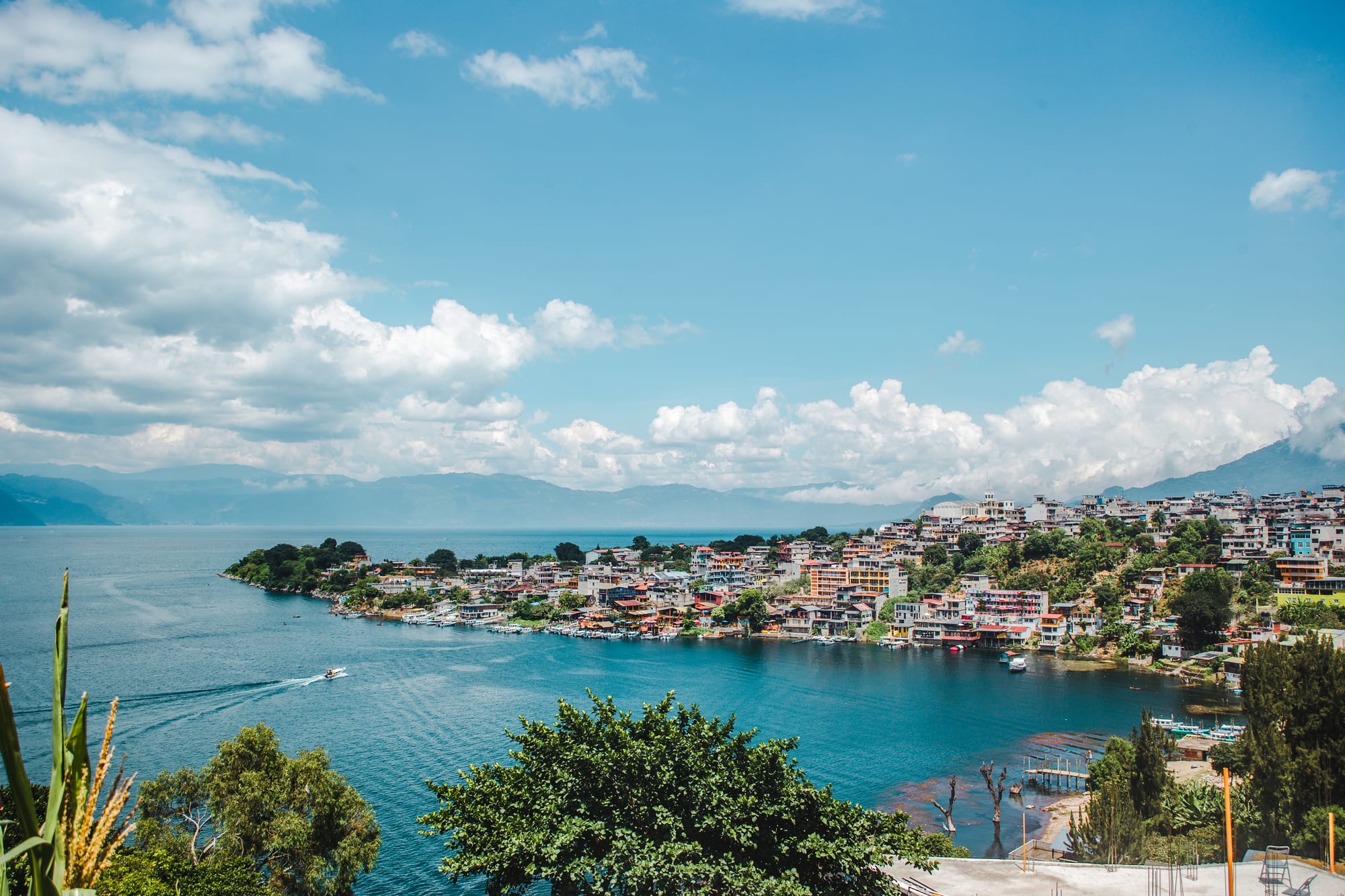
A hillside town of colourful buildings along a blue lake shore, with a boat crossing the water and mountains under white clouds

Lake Atitlán & the Western Highlands, Guatemala

San Pedro La Laguna

San Pedro La Laguna on the south-western shore of Lake Atitlán. (Toby Argüelles / Wikimedia Commons · CC BY-SA 2.0)

A Tz'utujil Maya town on the south-western shore of Lake Atitlán, spread over a plateau at the foot of the San Pedro volcano. Long a farming community growing maize, beans, coffee and avocados, it has become one of the lake's busiest backpacker villages, known for its Spanish schools, lakeside cafés, nightlife and volcano hikes.

Neighbourhoods

  • The Panajachel dock side
    • First-time visitors
    • Best for food
    • Nightlife

    The streets around the muelle municipal on the west side of the plateau, where boats from Panajachel arrive. Guesthouses, cafés, bars, street-food stalls and tour agencies crowd the lanes leading up from the water.

    Open in Maps
  • The Santiago dock side and the beach
    • Lake views
    • Spanish schools
    • Quiet and residential

    The east side, around the muelle Santiago where boats from Santiago Atitlán dock, with a small beach where people swim, snorkel and rent kayaks.

    Open in Maps
  • The upper town
    • Local life
    • Markets

    The centre of the Tz'utujil town on top of the plateau, with the market and the stop for buses from the highway, where life follows a local rhythm.

    Open in Maps

Things to do

The village and the lake

  • Museo Tz'unun 'Yamuseum

    A small museum of local history and customs, covering the formation of the lake and with colourised photographs of San Pedro before the civil war.

    Open in Maps
  • The lakeshore and kayakingbeach

    The small beach on the east side of town, where people swim, snorkel and rent kayaks to paddle along the shore.

    Open in Maps

Hikes and viewpoints

  • Volcán San Pedrotrail

    The 3,020-metre volcano rising directly above the town, a climb to views over the lake; armed robberies have happened on trails here, so going with a guide is recommended.

    Open in Maps
  • Indian Noseviewpoint

    The hill known as Nariz de Indio or Cara Maya, a popular viewpoint hike from San Pedro, best done with a guide for safety.

    Open in Maps

Short trips across the lake

  • San Juan La Lagunaattraction

    The neighbouring Tz'utujil village up the hill, with weaving and natural-dye cooperatives, where a local law prevents outsiders buying land.

    Open in Maps
  • Santiago Atitlánattraction

    The largest town on the lake, about half an hour by boat, a Tz'utujil community noted for its veneration of Maximón.

    Open in Maps
  • Panajachelattraction

    The lake's main gateway town on the north-eastern shore, about 45 minutes by boat, with craft sellers, a market and onward shuttles.

    Open in Maps
  • Lake Atitlánattraction

    The deepest lake in Central America, filling a volcanic caldera beneath the San Pedro, Tolimán and Atitlán volcanoes.

    Open in Maps

Eat and drink

Long-standing places and food districts in San Pedro La Laguna. Hours, ratings and directions come from your maps app, always current.

San Pedro classics

  • Street food near the Panajachel dockneighborhood

    Stalls on the lanes up from the Panajachel dock selling quick, cheap local food.

    Open in Maps
  • Lakeside cafés and restaurantsneighborhood

    Cafés, bars and restaurants along the lakeside paths between the two docks, serving locally grown coffee and food for international travellers, including Israeli dishes such as falafel.

    Open in Maps
  • San Pedro marketmarket

    The town market in the upper town, where buses stop and local families shop for produce.

    Open in Maps

Experience San Pedro La Laguna

History

For centuries the shore beneath the San Pedro volcano has been home to the Tz'utujil, one of the Maya peoples of Lake Atitlán. After the Spanish conquest the community was organised as an encomienda, a grant of Indigenous labour and tribute to a Spanish settler, and Catholicism, brought in the 16th century, became the dominant religion. The town grew on a plateau above the lake, its roads running down either side of a steep ridge to the water, and its people farmed maize, beans and later coffee and avocados on the volcano's slopes. In June 1925 the townspeople were granted rights to their municipal territory.

San Pedro remained relatively untouched by the wider violence of the civil war of 1960–96, but between 1980 and 1982 it suffered a series of kidnappings and murders, later attributed to local military commissioners; they ended in August 1982 when higher military officials intervened.

After the war, travellers discovered the town. Spanish schools opened, guesthouses and cafés spread along the lakeshore, and San Pedro became one of the lake's main destinations for backpackers and language students, with a small but growing community of foreign residents from North America, Europe and Israel.

Culture & Customs

San Pedro is overwhelmingly Tz'utujil, and Tz'utujil is the town's own Maya language. Some women still make belts, shawls and skirts on backstrap looms, and Indigenous medical traditions are still commonly practised by healers known as curanderos. The Museo Tz'unun 'Ya documents local history and customs.

Religion is layered. Catholicism has been dominant since the 16th century, but about half the population still practises traditional Maya rituals, separately or alongside another faith. The lake's afternoon wind, the Xocomil, is said to carry away sin, and if the wind blows from the north, local belief holds that the lake is giving up someone it has drowned.

The town has also become a centre for language learning around the lake, with many Spanish schools and students who stay for weeks, and it is known for its nightlife. In 2010 a synagogue and kosher restaurant opened for the growing number of Jewish visitors and residents, and many Israeli-run businesses have Hebrew signs. San Pedro also trains large numbers of teachers who work in schools around the lake.

Daily Life

The 2018 census counted about 11,000 people in the municipality, nearly all of them Tz'utujil, and the town is divided into cantons, among them Pacucha, Chuacante, Chuasanahi and Tzanjay. It lies in the department of Sololá, about an hour off the Pan-American Highway, with direct buses to Guatemala City and Quetzaltenango. Farming remains important, with maize, beans, coffee and avocados grown on the slopes of the volcano, alongside weaving, teaching and a large tourist trade of schools, guesthouses, restaurants, guides and boats.

Two worlds share the town. On the plateau the market and the buses from the highway set a local rhythm; down by the docks, travellers, language students and foreign residents fill the cafés, bars and guesthouses. Crossings are best made before the Xocomil rises around midday.

The health of the lake is a constant concern. In October 2016 the town banned single-use plastics, and residents have long complained of contamination from pollution, population growth and tourism, and of cyanobacteria, whose blooms have increased since 2009.

Food

San Pedro eats like the rest of the highlands. Tortillas come with every meal, alongside black beans, eggs, fresh cheese, chillies and herbs, and tamales and chuchitos are steamed in maize husks or leaves. Pepián, the seed-thickened stew, is cooked for fiestas, and atol, a warm maize drink, is sold at markets across the region. Much of the town's food is grown on its own slopes, from maize and beans to avocados.

Coffee is the town's other crop. It is grown around the volcano, and the village guides' association arranges coffee tours that follow the bean from the plant to the cup. Many cafés by the lake serve locally grown coffee.

For visitors, the lanes between the docks are lined with cafés, bars and restaurants catering to an international crowd, with menus that run from Guatemalan set lunches to falafel and other Israeli dishes, and cheap street food is sold near the Panajachel dock. Rum and aguardiente, cheap cane spirit, are widely drunk across the highlands.

Planning tools

Budget

San Pedro is one of the cheapest places on the lake. Dorms and simple guesthouses, street food and set lunches cost little, and many language students stay for weeks in homestays or rooms. Spanish lessons, guided hikes and boat trips are the main costs.

Daily Budget Midrange
USD 50–100 (lake-view room, restaurants, a guided hike and boat trips)
Daily Budget Shoestring
USD 20–35 (dorm or guesthouse, street food and comedores, public boats)

Carry cash in small notes for boats and tuk-tuks; arrange guides through the official village guides' association rather than through whoever meets the boat.

Best Time to Visit

November to April is dry and clear, the best time for climbing the volcano and for sunrise views. The wet season from May to October is green and quieter, with afternoon rain. Spanish schools run all year.

Suggested Number of Days

Two or three days suit a first visit. Allow up to a week to add a volcano or sunrise hike and boat trips to other villages, and longer for a Spanish course, which many students take by the week.

First Visit
2–3 days
With Surroundings
4–7 days

Transportation

The village is small and walkable, with roads running down either side of a ridge to the two docks; tuk-tuks are mainly useful for the climb up to the town centre or to San Juan. Public lanchas leave from the west dock for Panajachel and from the east dock for Santiago Atitlán.

Cross the lake in the morning, before the afternoon wind makes the water rough.

Airport & Station Connections

Boats cross from Panajachel in about 45 minutes and from Santiago Atitlán in about 30. Direct buses run from Guatemala City in about four hours and from Quetzaltenango in about three, and the town is about an hour off the Pan-American Highway. Tourist shuttles also come direct from Antigua. The nearest international airport is La Aurora in Guatemala City.

Walkability

Small and walkable, but hilly: the town sits on a plateau, and the lanes between the docks, the lakeshore and the upper town are steep.

Safety

Guatemala has significant crime, including gang activity and armed robbery, concentrated in parts of Guatemala City and on some highways and rural routes. The tourist circuit around the lake is generally calm, but robberies have occurred on some trails between the lake villages and on volcano and sunrise hikes. Drugs are offered to visitors at the docks.

Hike with local guides, avoid travelling at night on rural roads, and keep valuables out of sight. Check current official travel advice before travelling.

Climate

Mild all year at the lake's altitude, with a wet season from May to October and a dry season from November to April. The figures below are typical of the western highlands as a whole. The afternoon wind, the Xocomil, usually arrives around midday.

Summer
wet season (May–October): 15–24°C in the highlands, with afternoon rain
Winter
dry season (November–April): sunny days around 20–25°C, cooler nights

Local Customs

San Pedro is a Tz'utujil Maya community, more than 90 per cent Indigenous, where Catholicism and Maya ritual live side by side and healers known as curanderos still practise. Since 2016 the town has banned single-use plastics such as bags and straws, and shoppers bring their own bags and baskets.

Ask before photographing people and especially children, dress modestly away from the lakeshore and in church, and carry a reusable bag.

Common Payment Methods

The currency is the Guatemalan quetzal (Q). Some guesthouses, schools and restaurants take cards, but boats, tuk-tuks, street food and the market need cash.