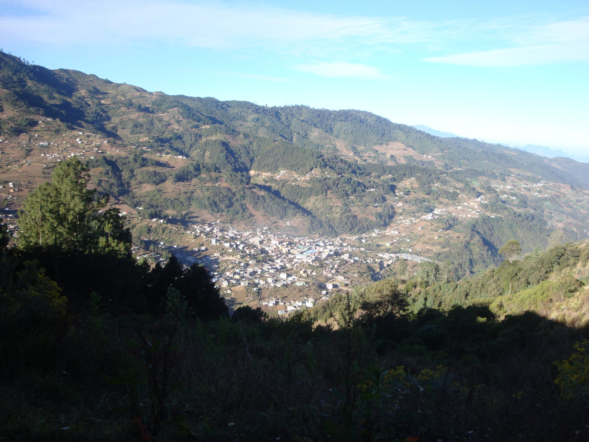
A small white town in the bottom of a steep green mountain valley, with farm plots and scattered houses on the slopes above

Lake Atitlán & the Western Highlands, Guatemala

Todos Santos Cuchumatán

Todos Santos Cuchumatán in its valley, seen from Cerro Tuicoj. (Jemm5150 / Wikimedia Commons · CC BY-SA 4.0)

A Mam Maya town about 2,500 metres up in the Sierra de los Cuchumatanes of Huehuetenango, the highest non-volcanic range in Central America. It is one of the few places in Guatemala where men as well as women still wear traditional dress, and it is known for the horse race at the heart of its All Saints' festival on 1 November.

Neighbourhoods

  • Parque Central
    • First-time visitors
    • Close to public transport

    The town centre, built around a raised central park with shops beneath it and a viewing platform over the town. Buses from Huehuetenango arrive and leave here, and the post office is on its south side.

    Open in Maps
  • East of the park
    • Shopping
    • Places to stay
    • Tourist information

    The road running east from the park, where most visitor services are found: shops selling the town's traditional clothing, internet cafés, tourist information stalls that arrange hikes, and several of the hotels.

    Open in Maps

Things to do

In the town

  • Parque Central viewing platformviewpoint

    The raised central park has a platform with views over the town and the valley around it.

    Open in Maps
  • Traditional clothing shopsmarket

    Shops along the road east of the park sell the clothing that the town's men and women wear every day.

    Open in Maps

Walks and mountains

  • Sierra de los Cuchumatanestrail

    The highest non-volcanic mountain range in Central America, whose cold limestone plateau above 3,000 metres rises over the town; local tourist offices arrange guided hikes.

    Open in Maps

Short trips from the town

  • Zaculeulandmark

    The restored ruins of the capital of the Postclassic Mam kingdom, with temple-pyramids, plazas, a ballcourt and a small museum, besieged and taken by the Spanish in 1525.

    Open in Maps
  • Huehuetenangoattraction

    The department capital on the Pan-American Highway, the last before the Mexican border at La Mesilla, and the starting point for buses up to Todos Santos.

    Open in Maps

Seasonal events

  • Feria of Todos Santos and the horse race31 October–2 November, with the race on 1 November

    The town's festival for All Saints' Day, with traditional dances, marimba music and the horse race, called Skach Koyl in Mam, in which riders in feathers, ribbons and red sashes gallop back and forth along a short track all day.

Eat and drink

Long-standing places and food districts in Todos Santos Cuchumatán. Hours, ratings and directions come from your maps app, always current.

Food in the town

  • Comedores around the parkneighborhood

    Simple eating houses in the centre, serving everyday Guatemalan food built on maize, beans and chillies.

    Open in Maps
  • The marketmarket

    The town market, a place to see the produce of the municipality's fields, from potatoes to cabbages, cauliflowers and carrots.

    Open in Maps

Experience Todos Santos Cuchumatán

History

The Mam Maya held these mountains long before the Spanish arrived, with their capital at Zaculeu near today's Huehuetenango. In 1525, after a siege of several months, Zaculeu fell to the conquistadors, and the Spanish took control of the region. The Mam were gathered into new settlements under encomiendas, grants of Indigenous labour to Spanish settlers, and Todos Santos was named for All Saints. Mercedarian friars ran its parish until 1754, when Bourbon reforms passed it to the secular clergy. In 1797 the town had 827 inhabitants, who raised sheep and sold wool.

After independence the town belonged in turn to various administrative districts, and in 1838–40 to the short-lived State of Los Altos, before becoming part of the department of Huehuetenango. The writer Maud Oakes wrote about the town in her books The Two Crosses of Todos Santos and Beyond the Windy Place.

Like much of the western highlands, the area has seen heavy emigration to the United States. In May 2000 a mob attacked a group of Japanese tourists and their Guatemalan bus driver after members of the group photographed local children, and the driver and one tourist were killed. Persistent rumours of child abduction still make residents protective of their families.

Culture & Customs

Todos Santos is one of the few places in Guatemala where Maya men as well as women still wear traditional clothing every day. The dress is kept in full: parents teach their children to wear it from birth, and it marks the town out with pride from the rest of the country, although women have been modernising some details of their dress. Shops in the town sell the clothing to visitors.

Mam, a Maya language spoken by around half a million people across western Guatemala and Chiapas in Mexico, is most people's first language, and Spanish is widely spoken as a second. People are relaxed and often happy to chat, but guard their privacy, and the request to ask before taking a photograph is meant seriously.

The great event of the year is the festival from 31 October to 2 November, centred on All Saints' Day. There are traditional dances and marimba music, and on 1 November the horse race, Skach Koyl in Mam. Riders in feathers, ribbons on their hats and red sashes and scarves gallop back and forth along a track of about a hundred metres all day. The race's origin is uncertain; one explanation is that it celebrates Mam who seized horses and escaped from the Spanish. The riders traditionally drink for days beforehand, and the race is often chaotic and sometimes bloody, even though the mayor banned the sale of hard alcohol in 2008.

Daily Life

The municipality covers about 269 square kilometres, with the town, six villages and 69 smaller rural communities, and its population was projected at about 40,000 in 2022, most of them Mam. The village of San Martín Cuchumatán, lower and warmer at about 1,800 metres, is the second centre and the agricultural heart of the valley.

Almost everyone lives from farming, with crops set by altitude. Potatoes are the most important, along with cabbage, cauliflower, carrots and maize; up to about 2,000 metres the traditional milpa of maize, beans and squash and coffee grow on the slopes, and broccoli is now grown on a large scale for export to the United States. On the cold limestone plateau above 3,000 metres, people live scattered among flocks of sheep and herds of cows and travel on horseback.

Farming fills most people's days, and across the highlands money sent home by relatives working in the United States pays for many of the new concrete houses.

Food

Food in Todos Santos is the plain fare of the cold highlands. Maize, beans and chillies are the base of traditional Guatemalan cooking, and potatoes are the municipality's most important crop. Tamales come in hundreds of varieties across Guatemala; chuchitos, which resemble Mexican tamales, are wrapped in maize husks, and pepián, a thick meat stew thickened with gourd seeds, is considered a national dish.

The surrounding fields fill the market with potatoes, cabbages, cauliflowers and carrots, and coffee is grown on the lower slopes of the municipality. Atol, a hot maize drink common across Guatemala, is welcome on cold mornings, and visitors eat in simple comedores in the centre. Further down the valley, in warmer San Martín, the slopes grow coffee, the traditional milpa of maize, beans and squash, and broccoli for export. At festival time the riders drink heavily for days, despite the 2008 ban on selling hard alcohol.

Planning tools

Budget

Todos Santos is cheap: simple hotels, comedor meals and the bus from Huehuetenango cost little. Guided hikes are the main extra, and rooms fill and prices rise around the 1 November festival.

Daily Budget Midrange
USD 45–90 (better guesthouse room, meals, a private guide for a mountain hike)
Daily Budget Shoestring
USD 20–35 (basic hotel, comedor meals, chicken buses)

Bring enough cash from Huehuetenango, carry small notes, and expect that people who agree to be photographed may ask for payment.

Best Time to Visit

The dry season, from November to March, is best for walking, with clear skies but cold nights. Rain is heavy from about April to November. The All Saints' festival from 31 October to 2 November is the busiest and most spectacular time.

Suggested Number of Days

The early and infrequent buses mean most visitors stay at least a night. Three or four days allow time for guided walks in the surrounding mountains, and the festival adds more.

First Visit
1–2 days
With Surroundings
3–4 days

Transportation

The town is small and walkable. Buses are the link with the outside world: direct buses from Huehuetenango leave very early in the morning, with more around midday, and stop near the park, where buses back to Huehuetenango also leave; at other times it may be necessary to change on the way.

Catch the early buses, avoid travelling on mountain roads after dark, and expect delays from landslides in the wet season.

Airport & Station Connections

Todos Santos is reached by bus from Huehuetenango, the department capital on the Pan-American Highway, which is itself 269 km by road from Guatemala City. The nearest international airport is La Aurora in Guatemala City.

Walkability

The town is compact and easy to cover on foot, though its streets climb the valley sides and the altitude, about 2,500 metres, makes uphill walking tiring at first. Walks into the surrounding mountains are best done with a local guide.

Safety

Guatemala has significant crime, including gang activity and armed robbery, concentrated in parts of Guatemala City and on some highways and rural routes. In Todos Santos the main concern is misunderstanding: persistent rumours of child abduction have made residents protective of their children, and in 2000 a mob attack after tourists photographed local children left two people dead. Mountain roads are steep and driven fast.

Photograph people, and above all children, only with clear permission, hike with local guides, and keep clear of drunken riders during the horse race. Check current official travel advice before travelling.

Climate

Altitude sets the climate. Across the municipality temperatures range from around freezing on the high plateau to 30°C in the warm valley of San Martín, and rain is heavy between April and November, although there are no reliable measurements.

Summer
wet season, about April to November: heavy rain; the region's highland figures are around 15–24°C
Winter
dry season: sunny days around 20–25°C for the region and cold nights near freezing on the high plateau

Local Customs

Todos Santos is a Mam Maya town: most people speak Mam as their first language, and Spanish is widely spoken too. Residents are relaxed and friendly with visitors, but very protective of their privacy and their families, and the traditional dress worn by the whole community is a matter of pride.

Always ask before taking photographs, especially of children, and respect a refusal; the sale of hard alcohol was banned in 2008, but heavy drinking is common at festival time.

Common Payment Methods

The currency is the Guatemalan quetzal. Todos Santos is a cash town: cards are rarely accepted and cash machines are scarce outside the department capitals, so it is best to bring enough quetzales from Huehuetenango.