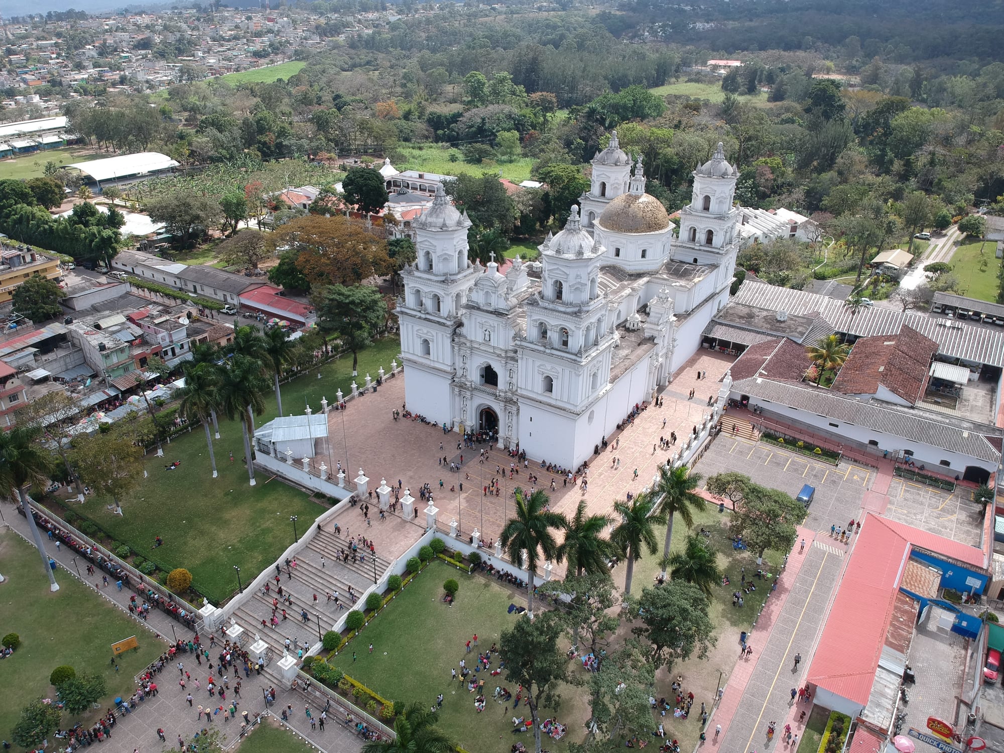
Aerial view of a large white baroque church with four towers and a dome, pilgrims crowding its steps and gardens

Guatemala

The East

The Basilica of Esquipulas in Chiquimula, home of the Black Christ and Central America's great pilgrimage shrine. (JMRAFFi / Wikimedia Commons · CC BY-SA 4.0)

Guatemala's hot, largely Ladino east, from the dry Motagua valley of El Progreso and Zacapa through the Ch'orti' Maya hills of Chiquimula to the volcanic uplands of Jalapa, Jutiapa and Santa Rosa on the borders with Honduras and El Salvador — cattle country, and home to the great pilgrimage shrine of Esquipulas.

Explore The East

History

Before the Spanish, the east was a frontier between peoples. The Ch'orti' Maya, related to the builders of Copán just across today's Honduran border, held the hills of Chiquimula; Poqomam Maya lived around Jalapa; and the Xinka, a non-Maya people with their own language, occupied much of Santa Rosa and Jutiapa. The Motagua valley was the source of the jadeite that the ancient Maya prized above gold, and small centres such as Guaytán, in El Progreso, stood along the river.

The Spanish conquest brought the Xinka and Ch'orti' under colonial rule, and epidemics and forced labour cut their numbers sharply. Over the colonial centuries the east became cattle and indigo country, settled by Spanish and mixed-race ranchers, and most of its people came to speak Spanish and identify as Ladino. In 1595 the carved figure of the Black Christ was installed in Esquipulas, and the town grew into the chief pilgrimage centre of Central America, with a basilica completed in the mid-18th century.

In the 1960s the first guerrilla movements of the civil war operated in Zacapa and neighbouring Izabal, and an army counter-insurgency campaign in 1966–68 defeated them at the cost of thousands of civilian lives. Esquipulas later gave its name to the Central American peace process, launched at a presidents' summit in the town in 1986. Since the war, the region's borders have made it a corridor for smuggling and drug trafficking.

Culture & Customs

The east is the heartland of Ladino Guatemala, often simply called el oriente. Its culture is rural and ranching: cowboy hats and boots, horses, rodeos, rancheras and a reputation within Guatemala for bluntness, pride and quick tempers. Eastern Spanish has its own accent and vocabulary, closer in places to Salvadoran and Honduran speech.

Indigenous communities remain. The Ch'orti' Maya live around Jocotán, Camotán and Olopa in Chiquimula, where women wear bright skirts and some villages still speak Ch'orti'. The Xinka of Santa Rosa, Jutiapa and Jalapa have organised to revive their nearly lost language and to defend their lands, and Poqomam is still spoken in parts of Jalapa.

Religion revolves around Esquipulas. The Black Christ, a crucifix of dark wood, is venerated by Catholics across Central America and southern Mexico, and pilgrims walk or ride for days to reach it, many visiting in January and at Holy Week. Pilgrims traditionally buy hats decorated with coloured paper and souvenirs to take home, and many visit the nearby Cueva de las Minas. Town fiestas across the region feature horse parades, marimba and fireworks.

Daily Life

The east is thinly visited but not empty. Its department capitals, Guastatoya, Zacapa, Chiquimula, Jalapa, Jutiapa and Cuilapa, are market and service towns for the surrounding ranches and farms, and Chiquimula is the region's commercial crossroads on the way to Honduras. Cuilapa promotes itself as the "centre of the Americas". Esquipulas lives from its pilgrims, with hotels, restaurants and souvenir stalls lining the approach to the basilica.

Farming is the backbone: cattle and dairy across the region, irrigated melons, tomatoes and tobacco in the Motagua valley around Zacapa, and coffee on the volcanic slopes of Santa Rosa, Jalapa and Jutiapa. Cross-border trade with El Salvador and Honduras is constant, and many families depend on money sent from the United States.

Much of the region lies in the dry corridor, where irregular rains and drought repeatedly destroy the maize and bean crops of small farmers, and Ch'orti' villages in Jocotán and Camotán have suffered serious hunger crises. Days begin before dawn to avoid the heat, and life slows in the middle of the afternoon.

Food

Eastern cooking is cattle-country food: grilled beef, fresh cheese, sour cream and thick tortillas, with beans and eggs at breakfast. Dairy is central, and Jalapa and Zacapa are known for their cheeses, crema and requesón, a soft curd cheese. Zacapa's quesadillas are not the Mexican dish but a sweet cake baked in a mould.

The Motagua valley grows melons and mangoes, eaten green with lime, salt and chilli from street carts. Closer to El Salvador, pupusas, thick maize cakes stuffed with cheese, beans or pork, are common, often flavoured with loroco, an edible flower bud. On the Santa Rosa coast, seafood soups and fried fish fill beach comedores.

Esquipulas is known for its sweets, sold to pilgrims from stalls around the basilica, including coconut sweets and sugar confections. The rum brand Zacapa is named after the town, though it is aged in the highlands, and cold beer is the drink of choice in the heat.

Attractions & Natural Wonders

Esquipulas, in the far south-east of Chiquimula, is the region's great sight: the white Basilica of the Black Christ, its plaza of pilgrims and stalls, and the hills around the town. Chiquimula itself has the ruins of its colonial Iglesia Vieja, and El Florido nearby leads to the ruins of Copán in Honduras.

The Motagua valley is Zacapa's world, with cactus-dotted hills, melon farms and a museum at Estanzuela. Downriver, just across the border in Izabal, the carved stelae of Quiriguá are Zacapa's famous neighbour. Above the valley rise the cloud forests of the Sierra de las Minas Biosphere Reserve, and the Maya site of Guaytán lies in El Progreso.

The volcanic south is full of crater lakes. The Ipala volcano, on the line between Chiquimula and Jutiapa, holds a lake in its crater, reached by a hike of a couple of hours. Jutiapa has the volcanoes of Suchitán and Chingo, the latter on the Salvadoran border. In Santa Rosa, Laguna de Ixpaco is a sulphurous crater lake, and the Los Esclavos bridge is a colonial bridge over the river of the same name.

On the coast, Monterrico's black-sand beach and the Monterrico reserve protect mangrove canals, birdlife and nesting sea turtles, with turtle hatcheries along the beach.

Cities in The East

Planning basics

Budget

The east is one of the cheapest parts of Guatemala because it sees few foreign visitors. Simple hotels and comedores in the department capitals cost little, and Esquipulas has plenty of pilgrim lodgings, although prices rise sharply and rooms fill around the January fiesta. Monterrico has a spread of beach hotels, busiest at weekends with visitors from the capital.

Daily Budget Midrange
USD 50–100 (better hotel with air conditioning, restaurants, a hired driver for the volcano lakes)
Daily Budget Shoestring
USD 25–40 (basic hotel, comedor meals, public buses)

Book Esquipulas well ahead for mid-January, and carry cash for rural areas, where cards are rarely accepted.

Safety

The east has some of Guatemala's highest homicide rates, linked to drug trafficking along the routes to Honduras and El Salvador, especially in parts of Zacapa, Chiquimula and Jutiapa; the violence rarely touches visitors, but armed robbery on roads occurs. Esquipulas is crowded but calm, with pickpockets during the fiesta. Heat is a real hazard, and Pacific beaches have strong currents.

Keep to main roads in daylight, drink plenty of water in the Motagua valley, swim only where locals do on the Pacific coast, and watch valuables in pilgrim crowds. Check current official travel advice before travelling.

Climate

The Motagua valley in El Progreso and Zacapa lies in a rain shadow and is one of the hottest and driest parts of Central America, with cactus and thorn scrub. The east forms much of Guatemala's dry corridor, where droughts ruin harvests. Jalapa and the volcanic uplands are cooler, and the Santa Rosa coast is hot and humid. Rains fall mainly from May to October.

Summer
wet season: 30–38°C in the Motagua valley, milder around 20–28°C in Jalapa, with afternoon storms
Winter
dry season: hot and sunny in the valleys, pleasant in the uplands, with cool nights on the volcanoes

Transportation

The Atlantic Highway runs from Guatemala City down the Motagua valley past El Rancho and the turn-off for Zacapa and Chiquimula, with frequent buses; Esquipulas is a few hours from the capital by road. The Inter-American Highway crosses Santa Rosa and Jutiapa to the Salvadoran border, and El Florido, near Chiquimula, is the crossing to Copán in Honduras. The volcano lakes are easiest with a hired car or driver.

Travel by day, and use direct pullman buses or shuttles on the long highway runs rather than local chicken buses.

Best Time to Visit

November to February is the most comfortable time, before the heat peaks in March and April. Esquipulas is at its most intense around the fiesta of the Black Christ on 15 January, and Holy Week also brings crowds. Sea-turtle hatchlings are released at Monterrico mainly in the second half of the year.