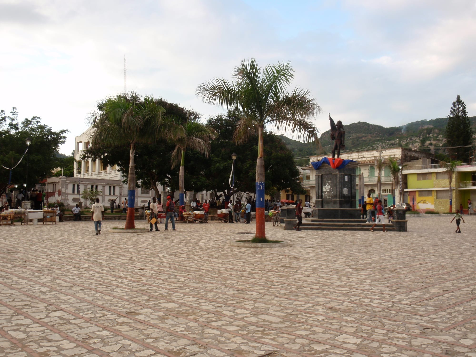
A paved cathedral square with palm trees painted blue and red, a bronze statue on a plinth and colourful buildings below green hills

Haiti

Cap-Haïtien

The cathedral square in the centre of Cap-Haïtien, with the hills behind the city. (Lionel Baur / Wikimedia Commons · CC BY-SA 3.0)

Haiti's main northern port, the former Cap-Français — capital of the French colony of Saint-Domingue and then of King Henri I's Kingdom of Haiti. Once called the Paris of the Antilles, it keeps a grid of old streets by the bay, with the Citadelle Laferrière and Sans-Souci Palace in the mountains to the south. This page is written to explain the city, not to encourage travel.

Neighbourhoods

  • The historic centre
    • Historic district
    • Markets

    The old colonial grid of numbered streets around the cathedral and its square, rebuilt after the 1842 earthquake with steel-framed French-style buildings, and filled with markets, churches and three- and four-storey houses from before and during the US occupation.

    Open in Maps
  • Boulevard du Carénage
    • Waterfront
    • Best for food

    The city's main boulevard, running along the sea on the northern side of town, lined with bars, restaurants and craft shops, with a promenade along the bay.

    Open in Maps
  • Vertières
    • History

    A district about 3.5 kilometres south of the centre, on the site of the last major battle of the Haitian Revolution in 1803.

    Open in Maps
  • The coast towards Labadie
    • Beaches

    West and north-west of the city the road follows a hilly coast of coves and beaches, including Cormier Plage and Belli Beach, towards the village and walled resort of Labadie.

    Open in Maps

Things to do

The old city

  • Our Lady of the Assumption Cathedrallandmark

    The cathedral on the square where the liberation of the slaves was proclaimed on 29 August 1793; damaged in 1842 and considerably altered in 1941–42.

    Open in Maps
  • Boulevard du Carénagetrail

    The seafront boulevard on the north side of the city, with bars, restaurants and craft shops facing the water.

    Open in Maps
  • Fort Picoletlandmark

    A coastal fort of 1739 built with two tiers of gun batteries, a rampart walk and a wall along the shore.

    Open in Maps

Revolutionary sites

  • Vertièreslandmark

    The site of the 1803 battle in which the French army was defeated, the last major battle of the Haitian Revolution.

    Open in Maps
  • Bois Caïmanlandmark

    The woods near the old Cap-Français where about 200 enslaved Africans met in 1791 and planned the first great uprising of the revolution.

    Open in Maps

Short trips from the city

  • National History Parkpark

    The protected area holding the Citadelle, Sans-Souci and the Ramiers fortifications, declared a UNESCO World Heritage Site in 1982.

    Open in Maps
  • Citadelle Laferrièrelandmark

    The largest fortress in Haiti and one of the largest in the New World, built by tens of thousands of former slaves on the 900-metre Bonnet à l'Evêque peak, 27 kilometres south of the city, to defend the young nation against a French return that never came.

    Open in Maps
  • Sans-Souci Palacelandmark

    The royal palace at Milot, built in 1810–13 and wrecked by the 1842 earthquake, now an empty ruin and one of Haiti's national icons.

    Open in Maps
  • Milotattraction

    The town about 19 kilometres south of Cap-Haïtien whose growth was shaped by Henri Christophe; it holds the palace, and the trail up to the citadel starts here.

    Open in Maps

The coast

  • Labadeebeach

    A walled cruise-ship beach compound 10 kilometres north-west of the city; cruise calls were suspended in March 2024 and then indefinitely in September 2025.

    Open in Maps
  • Cormier Plagebeach

    A beach on the coast road between the city and Labadie.

    Open in Maps
  • Belli Beachbeach

    A small sandy cove with boats on the coast towards Labadie.

    Open in Maps

Seasonal events

  • Independence Day and soup joumou1 January

    Haitians mark independence by eating soup joumou, the squash soup once forbidden to the enslaved.

  • RaraLent, peaking in Easter Week

    Street processions led by bands of bamboo vaksin trumpets and drums, celebrated across Haiti.

Eat and drink

Long-standing places and food districts in Cap-Haïtien. Hours, ratings and directions come from your maps app, always current.

Cap-Haïtien classics

  • Seafood on the Carénageneighborhood

    Restaurants along the seafront boulevard are known for seafood, above all lobster and lambi, conch.

    Open in Maps
  • Haitian platesrestaurant

    Rice and beans, flattened fried plantain and pikliz, the spicy cabbage relish, served in small restaurants across the centre.

    Open in Maps

Markets

  • Tourist Marketmarket

    A market of craft and souvenir stalls near the corner of Rue 24 and the Boulevard du Carénage.

    Open in Maps

Experience Cap-Haïtien

History

On this coast Christopher Columbus founded his first settlement in the Americas, the short-lived La Navidad, and the Spanish town of Puerto Real was founded nearby in 1503. Cap-Français was settled in 1670 by a dozen French adventurers under Bertrand d'Ogeron and formally founded in 1711, when it became the capital of Saint-Domingue. Its sugar wealth and sophistication earned it the name Paris of the Antilles, and it had about 15,000 inhabitants in 1790; the capital moved to Port-au-Prince in 1770, and Fort Picolet was built on the shore in 1739.

The revolution began in its hinterland. At Bois Caïman in 1791 enslaved Africans met to plan the uprising, the liberation of the slaves was proclaimed in the cathedral square on 29 August 1793, and on 18 November 1803 the French army was defeated at Vertières, on the city's southern edge. After independence Henri Christophe made himself King Henri I of a northern kingdom, renamed the city Cap-Henri, and built the Sans-Souci Palace and the Citadelle in the mountains at Milot; Haiti was reunited after his death in 1820.

On 7 May 1842 an earthquake estimated at magnitude 8.1, followed by a tsunami, destroyed most of the city. In February 2004 militants opposed to President Jean-Bertrand Aristide took over the city for most of that month. In 2021 a fuel tanker explosion killed more than 75 people, and after the capital's airport closed in March 2024 the city's airport was for a time the only functioning international airport in the country.

Culture & Customs

Cap-Haïtien sees itself as the cradle of Haitian independence and of an independent northern spirit, shaped by its distance from Port-au-Prince, the mountain barrier between north and south, and a history of large African populations. The Citadelle Laferrière, the Sans-Souci Palace and the Ramiers fortifications make up the National History Park, inscribed as a UNESCO World Heritage Site in 1982, and the Citadelle is regarded as a landmark of the whole nation.

The city's colonial grid, its cathedral and the steel-framed French-style buildings put up after 1842 give it an architecture unlike the capital's, and for Haiti's upper classes its bay, beaches and monuments made it a holiday destination comparable to Pétion-Ville. Music and religion follow national patterns: kompa at parties and on the radio, rara bands in Lent, and a mix of Catholicism, Protestant churches and Vodou.

The cruise-ship stop at Labadie long generated the largest share of Haiti's tourist revenue, and it was criticised for walling visitors off from the country and its culture while returning little to it. Cruise calls were suspended in March 2024 and then indefinitely in September 2025.

Daily Life

The commune had an estimated population of about 250,000 in 2009, of whom about 155,000 lived in the city itself; it is the capital of the Nord department. About three-quarters of its residents live in high-density districts, and around 72 per cent of its buildings stand in areas vulnerable to flooding.

The economy rests on the port, trade, small businesses and markets, with tourism and the cruise stop historically adding income. The seaport began a renovation financed by USAID in May 2024, and the airport was for a time the country's only functioning international airport after the capital's closed. Since 2021 fuel shortages have caused significant electricity outages. In 2020 the demolition of Shada 2, a slum of about 1,500 homes in the south of the city, was credited with disrupting gang activity, and the northern coast around the city has at times been more accessible than the capital.

Daily life centres on the markets that dot the city, the churches and the seafront boulevard in the evening, and on the struggle common across Haiti to keep children in school and food on the table.

Food

The north eats Haiti's Creole staples: rice and beans, flattened fried plantain that is not sweet, and pikliz, the spicy pickled-cabbage relish served with almost everything. Griot, pork marinated in citrus and epis seasoning and then fried, is the celebrated dish, and soup joumou is made in every household on 1 January to mark independence.

Being a port, the city is known for seafood, above all lobster and lambi, conch, which restaurants along the Boulevard du Carénage serve alongside Haitian, French and American dishes. Street food includes fritay, an assortment of fried snacks, and akasan, a thick spiced corn drink.

Everyday cooking also draws on diri djon djon, rice cooked black with tiny local mushrooms for special occasions; tasso, fried goat; and legim, a thick vegetable stew. Busy markets dot the city, and Haitian coffee is still grown in the mountains. Barbancourt rum, double-distilled from sugarcane in the manner of cognac, is one of Haiti's most admired products.

Planning tools

Budget

There is effectively no tourism industry in Haiti at present, and the cruise calls that once brought most foreign visitors to this coast have been suspended. The few who come — aid workers, diaspora Haitians and missionaries — usually arrange secured lodging and transport. Cash in US dollars and gourdes is essential.

Daily Budget Midrange
USD 150–350+ (secured hotel and arranged transport)
Daily Budget Shoestring
USD 150+ (no realistic shoestring option given the security situation)

Any movement is planned around security; independent travel is not advisable.

Best Time to Visit

In more normal times the drier months from December to March were the season. The Atlantic hurricane season runs from June to November. At present the security situation, not the weather, decides whether any visit is possible.

Suggested Number of Days

In calmer times two or three days covered the city, and another day was needed for the mountains to the south. Today the length of any stay is set by security and flight availability rather than by sightseeing.

First Visit
2–3 days
With Surroundings
3–4 days

Transportation

The old centre is a compact grid of numbered streets. Residents get around by tap-tap, shared pick-ups and buses, and motorbike taxis. Roads to the south and to Port-au-Prince are poor, and many routes through and around the capital are controlled by gangs.

The northern coast around Cap-Haïtien has at times been more accessible than the capital; take professional security advice before any road journey.

Airport & Station Connections

Cap-Haïtien International Airport, Haiti's second-largest, is on the south-east edge of the city. After Port-au-Prince's airport closed in March 2024 it was for a time the only functioning international airport in the country. Like the capital's airport, it is subject to closure during unrest, so flights should be confirmed before any plans are made.

Walkability

The historic centre and the Boulevard du Carénage are compact, and residents walk them daily. The beaches and the mountain sites to the south are reached by road, and any movement is governed by the security situation of the moment.

Safety

This is the decisive fact about Haiti today. Cap-Haïtien has been calmer than the capital — the 2020 demolition of the Shada 2 slum was credited with disrupting gang activity in the city — but it is not separate from the national crisis: fuel shortages have caused long power cuts since 2021, and in December 2021 a fuel tanker explosion in the Samari neighbourhood killed more than 75 people. Most governments advise against all travel to the country.

Globeway covers Haiti so it can be understood, not to encourage travel there now. Anyone with an unavoidable reason to go should take professional security advice and read their government's current advisory in full. Check current official travel advice before travelling.

Climate

Tropical, hot and humid on the coast and cooler in the mountains inland. The main rainy season runs from April to June with a second spell in October and November, and much of the city lies in areas vulnerable to flooding. The Atlantic hurricane season runs from June to November.

Summer
hot and humid — the Haitian coast is typically 28–34°C, with heavy rain in April–June
Winter
December to March is the drier season, still warm on the coast at around 28–34°C, and noticeably cooler at night in the mountains

Local Customs

Kreyòl is the everyday language and French the language of government and formal life. The city has a long history of independent thought, shaped in part by its distance from Port-au-Prince. Greetings come before any request, and churches and Vodou ceremonies are places of worship.

Ask before photographing people, especially in markets and at religious ceremonies; dress modestly in churches.

Common Payment Methods

The currency is the Haitian gourde, though prices are often quoted in the notional 'Haitian dollar' of five gourdes, and US dollars circulate widely. Cash is essential, as cards are accepted in few places and electricity and connections are unreliable.