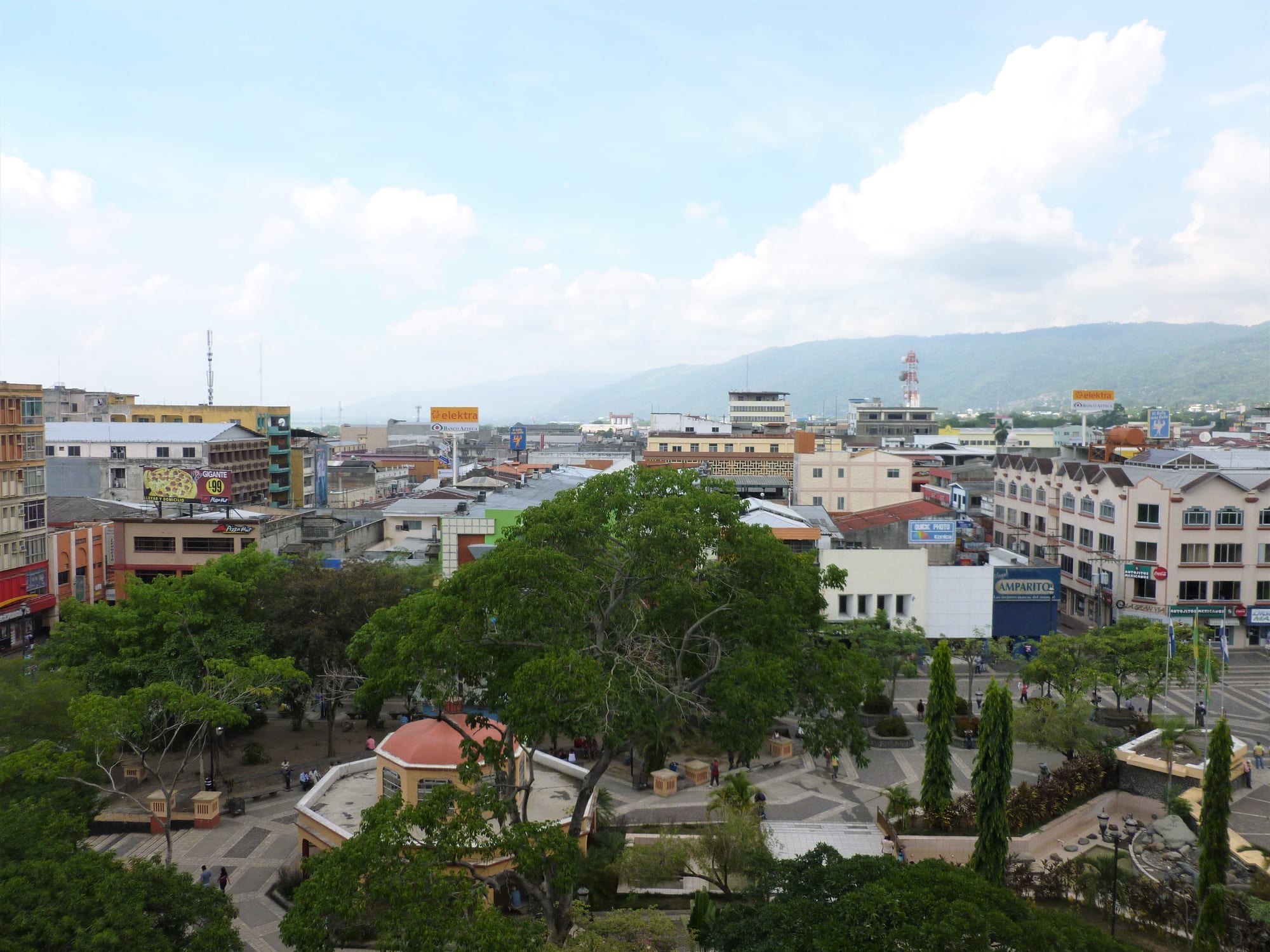
Trees and paths of the central park of San Pedro Sula below low-rise shops and offices, with green mountains on the horizon

San Pedro Sula & the North Coast, Honduras

San Pedro Sula

A view over central San Pedro Sula, with mountains on the horizon. (Jessica Towne / Wikimedia Commons · CC0)

Honduras's industrial and commercial capital, spread across the hot Sula valley beneath the Merendón mountains, about 50 km inland from the Caribbean port of Puerto Cortés. Founded by the Spanish in 1536 and made by bananas and railways, it grew into the country's second city and busiest air gateway — a working city of factories and malls that most visitors pass through on their way to the coast or Copán.

Neighbourhoods

  • The centre
    • First-time visitors
    • Markets

    The grid of streets around the Parque Central and the cathedral, compact enough to walk by day, with shops, an artisan market near the park and the anthropology museum. Busy in daylight, it empties after dark.

    Open in Maps
  • Barrio El Benque
    • Business district

    The business district just west and south of the centre, with offices and banks close to the old centre.

    Open in Maps
  • Zona Viva and the Circunvalación
    • Nightlife
    • Best for food

    The bar and restaurant district by the Avenida Circunvalación ring road, with grills, Mexican restaurants, karaoke and dancing, busiest from Thursday to Saturday; safe to walk only within a block or two.

    Open in Maps
  • The north-west colonias
    • Quiet and residential
    • Universities

    Residential neighbourhoods such as Colonia Moderna and Colonia La Mora running west from the Avenida Circunvalación, with the Universidad de San Pedro Sula nearby.

    Open in Maps

Things to do

The centre

  • San Pedro Sula Cathedrallandmark

    The Catholic cathedral of St Peter the Apostle, whose first stone was laid in 1949, and a symbol of the city's identity.

    Open in Maps
  • Parque Centralpark

    The main square in front of the cathedral, shaded by large trees — the place to watch the city go about its business.

    Open in Maps
  • Greek Orthodox Cathedral of St John the Baptistlandmark

    The Antiochian Orthodox cathedral of San Juan Bautista, built in 1963, in a city where about a tenth of the people are of Arab, mainly Palestinian, origin.

    Open in Maps
  • Museum of Anthropology and Historymuseum

    The city's museum of the Sula valley's past, with pre-Columbian pottery, grinding stones and other objects through to colonial times.

    Open in Maps
  • Artisan marketmarket

    A crafts market close to the Parque Central, with leatherwork, textiles, silver, jewellery and souvenirs from across Honduras.

    Open in Maps

Football and nights out

  • Estadio Olímpico Metropolitanoattraction

    A multi-purpose stadium with a capacity of more than 37,000, used mostly for football, with facilities for athletics.

    Open in Maps
  • Estadio Francisco Morazánattraction

    The home ground of Real España and sometimes Marathón, the city's two big clubs, which has staged World Cup qualifiers as well as concerts and parades.

    Open in Maps
  • Zona Vivaneighborhood

    The nightlife district by the Circunvalación, with bars, karaoke, live music at weekends and discos busy late into the night.

    Open in Maps

Short trips from the city

  • Cusuco National Parkpark

    A protected area in the Merendón mountains above the city, rising to 2,425 metres through pine forest, cloud forest and rare dwarf forest, known for its threatened amphibians and montane birds.

    Open in Maps
  • Puerto Cortésattraction

    The Caribbean port north of the city, the largest seaport in Central America by volume of traffic, which grew with the banana railway.

    Open in Maps
  • Fortaleza de San Fernando, Omoalandmark

    A Spanish colonial fortress built between 1756 and 1775 to guard the coast, still largely intact, in the fishing town of Omoa.

    Open in Maps
  • Lake Yojoapark

    The largest lake in Honduras, in a depression formed by volcanoes on the highway to the capital, where almost 400 bird species have been recorded and lakeside restaurants serve fried fish.

    Open in Maps
  • Ramón Villeda Morales International Airporttransit hub

    The busiest airport in Honduras, south-east of the city, the usual arrival point for the north coast and the islands.

    Open in Maps

Eat and drink

Long-standing places and food districts in San Pedro Sula. Hours, ratings and directions come from your maps app, always current.

San Pedro Sula classics

  • Baleadasrestaurant

    One of the most common street foods in Honduras, believed to have originated on the north coast, particularly in La Ceiba — a flour tortilla filled with refried beans, crumbled cheese and cream.

    Open in Maps
  • Fried and rotisserie chickenrestaurant

    Honduran fast-food chains and small shops selling fried and rotisserie chicken with tajadas are a city institution.

    Open in Maps

Food districts

  • Zona Vivaneighborhood

    The city's main district for grills, open-air restaurants and bars, with cheap Mexican food nearby on the Circunvalación.

    Open in Maps
  • Parque Centralneighborhood

    Cheap cafés, comedores and Mexican-style taquerías around the central square, busy at breakfast and lunch.

    Open in Maps

Experience San Pedro Sula

History

On 27 June 1536 the conquistador Pedro de Alvarado founded a Spanish town beside the Indigenous settlement of Choloma, calling it Villa de Señor San Pedro de Puerto Caballos. It began with 35 Spanish citizens and 200 enslaved people to build it and work the fields, and the conquest brought a collapse of the native population from which it never recovered. In 1601 Spain made Santo Tomás the official port of its Central American colonies, diverting trade from Puerto Caballos, and the town declined: it had only 70 inhabitants in 1714 and 357 in 1789.

Bananas and railways revived it. The Interoceanic Railroad, built between 1869 and 1874, linked the town to the coast at Puerto Cortés, and the banana trade of the 1870s and 1880s brought growth; in 1875 the population was reported at 1,200. The city formed close ties with Samuel Zemurray's Cuyamel Fruit Company, which worked with local elites and paid very few taxes. In the twentieth century migrants from the interior and from abroad, among them Palestinians, came to the growing city.

In the later twentieth century San Pedro Sula became the country's industrial centre, filled with textile maquilas and migrants from the countryside. Hurricane Mitch in 1998 left a lasting mark on the banana industry around the city. From the 2000s the city became the centre of gang violence; it was described as the murder capital of the world until early 2016, and in 2013 it recorded 187 homicides per 100,000 residents. Homicide rates in Honduras have since fallen from their peak.

Culture & Customs

San Pedro Sula sees itself as the country's engine — practical, commercial and hard-working, in contrast to the government city of Tegucigalpa. Its mix is distinctive: about a tenth of the people are of Arab, mainly Palestinian, origin, an Antiochian Orthodox cathedral built in 1963 stands alongside the Catholic cathedral begun in 1949, and migrants from the Honduran interior, North America and Europe settled here in the twentieth century.

Football is the city's passion. It is the only Honduran city with two major football stadiums, and its two most popular clubs, Marathón and Real España, divide the city; the larger Estadio Olímpico Metropolitano also has facilities for athletics. Nights out centre on the Zona Viva, with karaoke, live music at weekends and discos that fill late.

The Museum of Anthropology and History tells the story of the Sula valley from pre-Columbian times, and the crafts market near the Parque Central gathers leatherwork, textiles and silver from around the country. The city is also the starting point for journeys to the Maya ruins of Copán, the Garífuna coast and the Bay Islands.

Daily Life

San Pedro Sula had 701,200 people in its central urban area in 2023 and 1,445,598 in its metropolitan area, making it the second city of Honduras and the largest city in Central America that is not a capital. Its metropolitan area in the Sula valley is the second most populous in Honduras.

The economy rests on industry, commerce and finance: textile and apparel maquilas and trade through Puerto Cortés, the largest seaport in Central America by volume of traffic. The banana industry around the city has never fully recovered from Hurricane Mitch, and in some years manufacturing has struggled too.

The city is divided into barrios and colonias spreading out from the centre: the business district of El Benque, residential colonias in the north-west, and poorer districts on the edges, among them Chamelecón to the south, which has been under heavy pressure from street gangs. Gang violence and extortion weigh heavily on daily life in the poorer districts. Heat sets the rhythm: early starts, air-conditioned malls at midday and busy evenings.

Food

The baleada, the north coast's favourite food and one of the most common street foods in Honduras, is believed to have originated on this coast, particularly in La Ceiba: a flour tortilla filled with refried beans, crumbled cheese and mantequilla, a cream, with eggs, avocado or meat added. Pastelitos are a common snack, and chicken is often served with tajadas, slices of fried green plantain.

Fried and rotisserie chicken is a city institution, sold by Honduran chains such as Pollos El Hondureño and by small local shops. Grills and steakhouses serve Honduran-style beef and chicken, particularly in the Zona Viva; the city also has Mexican and Italian restaurants, and cheap Mexican-style taquerías around the Parque Central are busy at breakfast and lunch.

Everyday Honduran plates of rice, beans, plantain, cuajada (fresh cheese), cream and tortillas are served in comedores across the city. Salva Vida is one of the big Honduran beers, and fried fish from the lakeside restaurants of Lake Yojoa is the classic meal on the road south to the capital.

Planning tools

Budget

Prices are close to the national average. Business hotels and chain restaurants push costs up near the malls and the Circunvalación; simple hotels and comedores in the centre are cheap. Taxis are inexpensive and are needed for almost every trip after dark.

Daily Budget Midrange
USD 65–140 (business hotel, restaurant meals, taxis and a driver for day trips)
Daily Budget Shoestring
USD 25–45 (guesthouse, comedor meals, taxis)

Many travellers treat the city as a transit point; arrange airport transfers in advance and use taxis rather than walking at night.

Best Time to Visit

The dry season runs from about January to May, though March and April are the hottest months. Rain is possible in any month, the wet season covers the rest of the year, and the hurricane season runs from June to November.

Suggested Number of Days

A day covers the centre. Three or four allow time for the mountains, the nearby coast and the lake country to the south; most travellers stay only a night between flights and onward buses.

First Visit
1 day
With Surroundings
3–4 days

Transportation

Taxis are plentiful and cheap and are the safest way to move around, especially after dark. The centre is compact enough to walk by day. City buses are not recommended for visitors. Long-distance buses leave from the Gran Central Metropolitana terminal on the Bulevar del Sur.

Take a taxi even for a few blocks after dark, and agree the fare first.

Airport & Station Connections

Ramón Villeda Morales International Airport, the busiest in Honduras, handling about 1.27 million passengers in 2023, is 11 km south-east of the city; taxis wait at the terminal. Direct buses link the city with Tegucigalpa, Tela and La Ceiba, Puerto Cortés, Santa Rosa de Copán and neighbouring countries. The Maya site of Copán, near the Guatemalan border, is usually reached by road from here.

Walkability

The centre is flat and compact, laid out on a grid of numbered streets and avenues, and can be walked by day. The rest of the city is spread out along busy boulevards. Midday heat is intense, and walking after dark is not advised anywhere except within a block or two of the Zona Viva.

Safety

Honduras has had one of the highest homicide rates in the world, driven by gangs (MS-13 and Barrio 18) and drug trafficking, and San Pedro Sula and parts of Tegucigalpa remain dangerous. The city was for several years among the most violent in the world, and gang extortion and armed robbery remain serious in its poorer districts and in Choloma.

Do not walk around at night or use city buses, take taxis even for short distances after dark, and never travel by road at night. Check current official travel advice before travelling.

Climate

Hot and humid all year, with some rain in every month. The dry season runs from about January to May, March and April are the hottest months, and the wet season covers the rest of the year. From November to mid-February cold fronts from the north can bring cooler spells, and hurricanes and tropical storms are a risk from June to November.

Summer
hot and humid, 28–35 °C across the north-coast region as a whole, with the wet season and the hurricane season from June
Winter
warm, with cooler spells when cold fronts arrive from the north, which can occasionally bring temperatures down to about 15 °C

Local Customs

San Pedro Sula is a business city, informal in dress but polite in manner; handshakes and 'buenos días' open every exchange. Football matters, with Marathón and Real España the city's rivals. The city's community of Arab, mainly Palestinian, origin makes up about a tenth of its people.

Keep phones and jewellery out of sight in the street, ask before photographing people, and dress modestly in churches.

Common Payment Methods

The currency is the Honduran lempira. Cards are widely accepted in malls, hotels and restaurants; taxis, markets and comedores need cash in small notes.