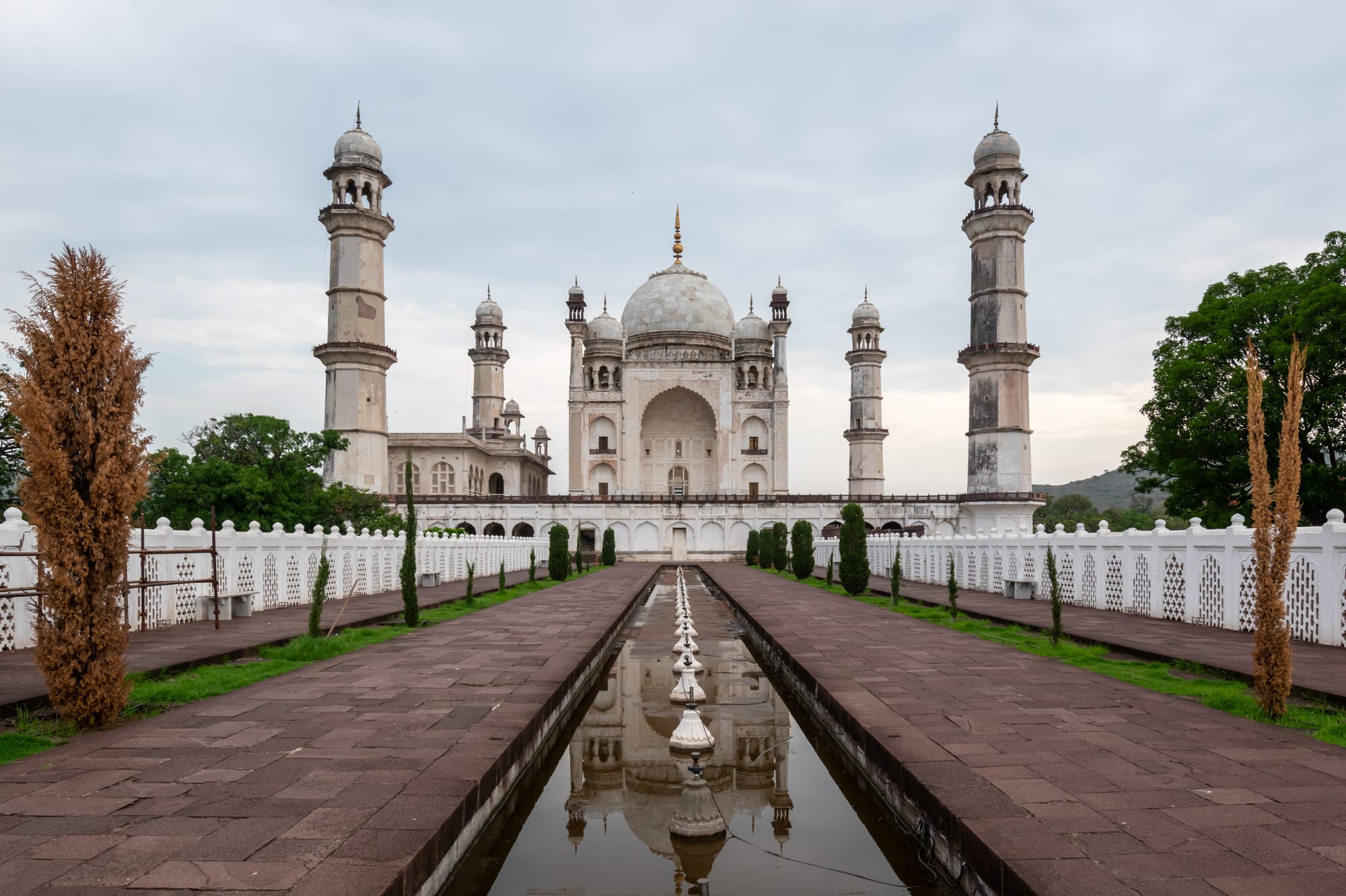
A white domed marble tomb with four minarets at the end of a long water channel and paved garden walk

Mumbai, Goa & the West, India

Aurangabad

Bibi Ka Maqbara, the 17th-century tomb in Aurangabad built for Dilras Banu Begum. (Rohit Sharma / Wikimedia Commons · CC BY-SA 4.0)

A Deccan city in central Maharashtra, renamed Chhatrapati Sambhajinagar by the state in 2023, that grew under the Nizam Shahi and Mughal rulers and served as Aurangzeb's southern capital. Its walls, gateways and the marble tomb of Bibi Ka Maqbara survive, and it is the base for the rock-cut caves of Ellora and Ajanta and the hill fortress of Daulatabad.

Neighbourhoods

  • The old walled city
    • Historic district
    • Markets
    • Best for food

    The dense quarter inside the surviving city wall, entered through gateways such as Delhi Gate and Bhadkal Gate. Narrow lanes run between mosques, old havelis and the bazaars of Gulmandi and City Chowk, and the food here is the city's most distinctive.

    Open in Maps
  • Begumpura
    • Landmarks
    • Quiet and residential

    The northern suburb laid out in the Mughal period, where Bibi Ka Maqbara stands in its walled garden and the Panchakki water mill and shrine sit beside the Kham river. Residential streets and college campuses fill the ground between them.

    Open in Maps
  • Kranti Chowk and the Jalna Road corridor
    • Hotels
    • Restaurants
    • Close to public transport

    The modern commercial spine running east from the centre, lined with hotels, showrooms, offices and chain restaurants, and the easiest base for anyone arriving by air or setting out early for the caves.

    Open in Maps
  • CIDCO and the northern suburbs
    • Quiet and residential
    • Families

    Planned residential sectors built from the 1970s, with wide roads, markets, schools and parks. Everyday life for much of the city's middle class happens here rather than in the old town.

    Open in Maps
  • Chikalthana and Waluj
    • Close to the airport
    • Business travel

    The airport lies at Chikalthana on the eastern edge, while Waluj to the south-west is one of Maharashtra's larger industrial estates, with car, pharmaceutical and brewing plants that employ much of the working population.

    Open in Maps

Things to do

Famous landmarks

  • Bibi Ka Maqbaralandmark

    A marble-faced tomb of the 1660s built for Dilras Banu Begum, wife of Aurangzeb, by their son Azam Shah, closely modelled on the Taj Mahal at smaller scale and set in a formal garden.

    Open in Maps
  • Panchakkilandmark

    A 17th-century water mill and garden complex fed by an underground channel from the hills, built beside the shrine of the Sufi Baba Shah Musafir.

    Open in Maps
  • Daulatabad Fortlandmark

    A hill fortress on a conical rock west of the city, the Yadava capital of Devagiri, to which Muhammad bin Tughluq tried to move Delhi's population in the 14th century; it is climbed by stepped passages cut through the rock.

    Open in Maps
  • Chand Minarlandmark

    A tower of four storeys and 63 metres inside Daulatabad Fort, erected in 1445 to mark a Bahmani victory over the Vijayanagara Empire.

    Open in Maps
  • Aurangabad Caveslandmark

    Twelve Buddhist caves in three groups cut into the hills just north of the city, chiefly in the 6th and 7th centuries, with carved shrines and views over Bibi Ka Maqbara.

    Open in Maps

The rock-cut caves

  • Ellora Caveslandmark

    A UNESCO World Heritage Site of 34 Buddhist, Hindu and Jain caves cut along a basalt escarpment, including the Kailasa temple, carved downwards from the rock as a free-standing temple in the 8th century.

    Open in Maps
  • Ajanta Caveslandmark

    A UNESCO World Heritage Site in a horseshoe gorge to the north, with some thirty Buddhist cave monasteries and halls of the 2nd century BC to about the 5th century AD, famous for their wall paintings.

    Open in Maps
  • Pitalkhoralandmark

    An early group of Buddhist caves in the Satmala hills, dating back to the 3rd century BC and among the oldest rock-cut monuments in India, reached by a steep flight of steps past a waterfall.

    Open in Maps

Short trips from the city

  • Khuldabadattraction

    A walled town of Sufi shrines near Ellora, where Aurangzeb was buried in a plain open grave beside the dargah of his spiritual teacher.

    Open in Maps
  • Grishneshwar Templelandmark

    A Shiva temple near Ellora, rebuilt in its present form in 1729 under Holkar patronage, one of the twelve jyotirlinga shrines.

    Open in Maps
  • Paithanattraction

    An old town on the Godavari south of the city, known in antiquity as Pratishthana, the source of the Paithani silk sari and the site of the Jayakwadi dam and its bird-rich reservoir.

    Open in Maps
  • Lonar Lakeattraction

    A saline crater lake formed by a meteorite impact in basalt, ringed by forest and old temples, well east of the city in Buldhana district.

    Open in Maps

Seasonal events

  • Ganesh ChaturthiAugust or September

    Ten days of neighbourhood pandals, processions and drumming before the clay images of Ganesh are immersed in the city's lakes and tanks.

  • Shiv JayantiFebruary

    The birth anniversary of Chhatrapati Shivaji, marked across Maharashtra with processions and decorated motorcades.

  • Maha ShivaratriFebruary or March

    The night of Shiva, when large crowds gather at the Grishneshwar temple near Ellora and at Shiva shrines across the district.

  • Ramadan nights in the old citythe month of Ramadan

    Food stalls stay open late around the gates and bazaars of the walled city for the breaking of the fast, selling kebabs, haleem and sweets.

Eat and drink

Long-standing places and food districts in Aurangabad. Hours, ratings and directions come from your maps app, always current.

Aurangabad classics

  • Naan qaliarestaurant

    The city's signature dish — mutton cooked with a heavy mix of Deccan spices and eaten with tandoor-baked naan — sold at old kitchens in and around the walled city.

    Open in Maps
  • Mughlai and Deccan grillsrestaurant

    Biryani, kebabs, haleem in Ramadan and tahri are the everyday Muslim cooking of the old quarter, served in plain rooms with cups of sweet tea.

    Open in Maps
  • Maharashtrian thali housesrestaurant

    Vegetarian thalis of bhakri or chapati, pulses, a fiery zunka or bharli vangi of stuffed aubergine and pickles, in the canteens along the main roads.

    Open in Maps

Markets and street food

  • Gulmandi and City Chowk bazaarsmarket

    The old city's main shopping streets, crowded with cloth, spice, dry-fruit and sweet shops and with carts selling snacks into the evening.

    Open in Maps
  • Shahganj marketmarket

    A bazaar around an old mosque in the centre, good for household goods, produce and cheap eating.

    Open in Maps

Experience Aurangabad

History

The city sits on an old route across the Deccan, and the region around it was inhabited long before the town existed: the Ajanta caves were cut from about the 2nd century BC, the Ellora cliffs from the 6th century AD, and the Yadava dynasty ruled from the rock fortress of Devagiri, later Daulatabad, until the region was annexed by the Delhi Sultanate under Alauddin Khalji in 1308. Muhammad bin Tughluq made Daulatabad his capital in 1327 and ordered the population of Delhi to move there, an experiment abandoned within years.

Aurangabad itself was founded in 1610 as Khadki by Malik Ambar, the Ethiopian-born minister and general of the Nizam Shahi sultanate of Ahmadnagar, who laid out its water supply and defences. The Mughals took it, and the city was renamed for the emperor Aurangzeb, who made it his base for decades of campaigning in the south and died in the Deccan in 1707; he was buried at Khuldabad. The marble tomb of Bibi Ka Maqbara was raised in the 1660s for his wife, and the ring of gateways and the Panchakki mill date from the same era.

After Aurangzeb's death the Nizams of Hyderabad held the city, and it stayed under Hyderabad rule until the state was absorbed into India in 1948; the city passed to Bombay State in 1956 and the Marathi-speaking Marathwada region became part of Maharashtra in 1960. Industry arrived from the 1970s with the Waluj and Chikalthana estates. In 2023 the state government renamed the city Chhatrapati Sambhajinagar after Shivaji's son, a change that was long debated and is now the official name, although the older name remains in wide use.

Culture & Customs

Aurangabad is a meeting point of Marathi and Deccani Muslim culture. Marathi is the language of the state and of most residents, but the old city has spoken Dakhni Urdu for centuries, and mosques, dargahs and Sufi shrines stand among temples across the district. The result is visible in the food, the music and the calendar, where Ganesh Chaturthi processions and Ramadan nights fall in the same year and often in the same streets.

Weaving is the city's craft tradition. Himroo, a fabric of silk and cotton woven with patterned brocade motifs, is associated with Aurangabad and said to descend from the court textiles of the Tughluq period; Paithani saris, with their tapestry-woven silk borders of peacocks and lotus in gold thread, come from Paithan to the south and are worn for Maharashtrian weddings. Workshops in the city still weave both, and bidri metalwork inlaid with silver is sold in the bazaars.

Marathwada's identity is bound up with Marathi saints and the Varkari devotional tradition, whose pilgrims walk to Pandharpur, and with the social reform movement of B. R. Ambedkar, after whom the city's university is named. Hospitality is formal and tea is offered at every meeting; visitors are expected to dress modestly and to remove shoes at shrines of either faith. The naming of the city is a live political subject, and both names are heard in daily conversation.

Daily Life

About 1.2 million people lived in the city at the 2011 census, making it the largest in the Marathwada region and one of Maharashtra's bigger urban centres. The economy rests on three legs: manufacturing in the Waluj, Shendra and Chikalthana industrial estates, where cars, motorcycle parts, pharmaceuticals, seeds and beer are made; tourism built on the World Heritage cave sites; and government, education and trade for a large agricultural hinterland.

Most residents live in the newer northern and eastern suburbs rather than the walled city, commuting by two-wheeler and autorickshaw along Jalna Road. The old quarter remains the commercial and wholesale centre, busiest in the morning and again after dark. Marathwada is a dry-farming region of cotton, sugar cane, pulses and mosambi citrus, and the fortunes of the countryside are felt in the city's markets.

Water is the constant issue. The district depends on the Jayakwadi reservoir on the Godavari, and in poor monsoon years supply to households is rationed to a few days a week; drought, farm debt and migration for work are recurring problems across the region. Air quality, traffic on the expanding arterial roads and the pressure of visitor numbers at the cave sites are the other subjects of local debate.

Food

The dish most associated with the city is naan qalia: mutton on the bone cooked with a dense mixture of Deccan spices into a thin, dark gravy, eaten with naan baked in a tandoor. It is said to have been fed to Mughal soldiers and is still made at old kitchens in and near the walled city. Alongside it come biryani in the Deccan manner, seekh and shami kebabs, and, during Ramadan, haleem — wheat and meat pounded for hours into a thick porridge — sold in the evening by the gates.

Maharashtrian home cooking is the other half. Bhakri, a flatbread of jowar or bajra, is eaten with pithla or zunka of gram flour, a dry vegetable dish, raw onion and a sharp chutney of garlic and red chilli. Bharli vangi, small aubergines stuffed with coconut and peanut masala, and the Marathwada style of mutton rassa are regional standards, and thalis in the town's canteens serve them with rice, dal and pickles.

Sweets are simple and rich: shrikhand, strained yoghurt with saffron and cardamom, eaten with puris; puran poli, a flatbread stuffed with sweet lentils and jaggery for festivals; and jalebi and pedha from the bazaar sweet shops. Mosambi juice from the district's citrus orchards, sugar-cane juice, lassi and strong milky tea are the everyday drinks.

Planning tools

Budget

Aurangabad is inexpensive by Indian city standards, and much better value than Mumbai or Goa. The main costs are the hired car or tour that reaches Ellora and Ajanta, the monument entry fees at both sites, and mid-range hotel rooms along Jalna Road. Food, autorickshaws and buses cost very little.

Daily Budget Midrange
USD 45–110 (mid-range hotel, restaurant meals, a car with driver for the caves, monument fees)
Daily Budget Shoestring
USD 15–30 (guesthouse room, thalis and street food, state buses and shared autos)

Sharing a car with other travellers makes the cave trips far cheaper, and state buses reach Ellora and Daulatabad for a fraction of the cost.

Best Time to Visit

November to February is the comfortable season, dry and mild, and the best time for the long days at the caves. March to May is very hot on the Deccan, often above 40°C. The monsoon from June to September brings green hills and waterfalls over the Ellora escarpment, with heavy rain at times; Ajanta's gorge is at its most striking then.

Suggested Number of Days

Two days cover the city's monuments. Three or four allow the cave sites and the fort as well, since each lies at a distance and takes most of a day. Heat, the season and whether a car is hired all change the figure.

First Visit
2 days
With Surroundings
3–4 days

Transportation

Autorickshaws are the standard way around town, with shared autos on fixed routes and city buses on the main roads. Ride-hailing apps work patchily. Almost everyone reaches the caves by hired car with driver or by Maharashtra state bus: Daulatabad is about 15 kilometres out, Ellora about 30, and Ajanta roughly 100 kilometres north-east, the last a journey of two to three hours each way.

Agree an autorickshaw fare before setting off, and start early for Ajanta, where visitors transfer to shuttle buses at the car park below the gorge.

Airport & Station Connections

Chhatrapati Sambhajinagar Airport at Chikalthana, about 6 kilometres east of the centre, has flights from Mumbai, Delhi and other Indian cities. The railway station is on a branch of the Central Railway with trains from Mumbai, Nanded and Secunderabad, and the journey from Mumbai takes about seven hours by train or six to seven by road via the expressway and Nashik. State and private buses arrive from Pune, Nashik and Mumbai.

Walkability

The old walled city is walkable and rewarding on foot, with gateways, mosques and bazaars packed into a small area. The rest of the city is spread out along wide roads with fast traffic, patchy pavements and long gaps between sights, so an autorickshaw is the practical choice; Bibi Ka Maqbara and Panchakki are a few kilometres from the centre. Summer heat discourages walking in the middle of the day.

Safety

Aurangabad is a calm provincial city with little crime aimed at visitors. The everyday risks are road traffic, pickpocketing in crowded bazaars, heat and dehydration from March to May, and the steep, dark and uneven passages inside Daulatabad Fort. Monkeys at the cave sites snatch food and bags.

Carry water and cover the head at the caves, take care on the fort's stairs and tunnels, keep bags closed in bazaars and use a torch where passages are unlit. Check current official travel advice before travelling.

Climate

A semi-arid climate on the Deccan plateau, drier than the coast. The year divides into a hot season, a moderate monsoon and a mild, dry winter, and the altitude of roughly 550 metres keeps nights cooler than in Mumbai.

Summer
hot and dry, commonly 35–42°C in April and May, with monsoon rain and humid air from June to September
Winter
mild and dry, roughly 15–30°C, with cool mornings in December and January and clear skies

Local Customs

Marathi is the main language, with Urdu and Hindi widely spoken in the old city. Modest dress is expected, particularly at mosques, dargahs and temples, where shoulders and knees are covered and shoes left outside; women may be asked to cover their heads at shrines. Greetings are namaskar or adab, and the right hand is used for eating and giving.

Photography is restricted inside some cave shrines and flash is not allowed at Ajanta's paintings; permission should be asked before photographing people or at prayer times.

Common Payment Methods

The currency is the Indian rupee. Cards work in hotels and larger restaurants, and UPI phone payments are accepted almost everywhere, including small shops and many autorickshaws. Cash is still useful for bazaars, buses and the cave sites, and ATMs are common in the city but scarce out at Ajanta.