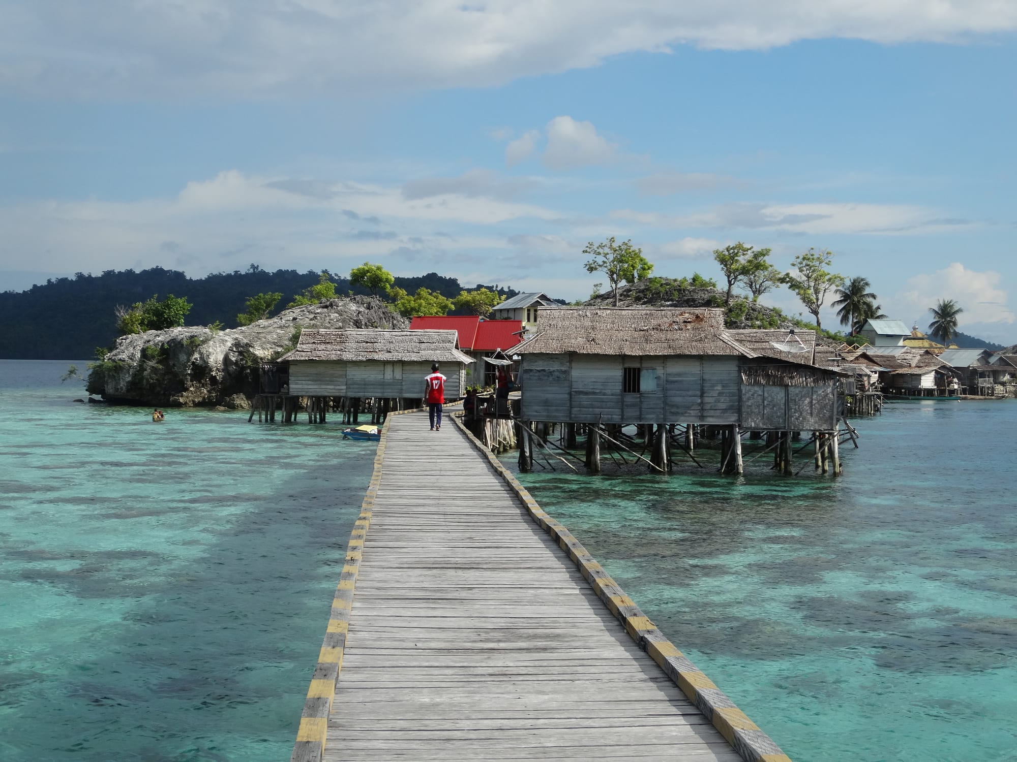
A wooden walkway leading to stilt houses built over clear turquoise water beside a small rocky island

Sulawesi, Indonesia

Togian Islands

The Bajau stilt village of Kabalutan in the Togian Islands. (Benoît Vicart / Wikimedia Commons · CC0)

A chain of forested islands in the Gulf of Tomini, off the central waist of Sulawesi, reached only by ferry from Ampana or Gorontalo. Fringing and barrier reefs surround them, the villages are small and mostly Muslim, and the visitor economy is a scattering of simple beach bungalows. Wakai, on Batudaka, is the main settlement and boat hub.

Neighbourhoods

  • Wakai
    • First-time visitors
    • Boats and ferries
    • Local life

    The main village of the islands, on Batudaka, where the ferries tie up and resort boats meet arrivals. Shops, a market, a few losmen and the only real concentration of services are here, and almost everyone passes through it at least twice.

    Open in Maps
  • Kadidiri
    • Beaches
    • Diving
    • First-time visitors

    A small island a short boat ride from Wakai with a beach, a shallow reef offshore and a handful of bungalow places strung along the sand. It is the most visited base in the archipelago and the easiest place to arrange diving.

    Open in Maps
  • Bomba and southern Batudaka
    • Quiet and residential
    • Snorkelling

    The quiet western end of the chain, nearest to Ampana, with a village, reefs offshore and a few simple guesthouses. Fewer people come this far west, and the pace is slower still.

    Open in Maps
  • Katupat and Malenge
    • Quiet and residential
    • Snorkelling
    • Local life

    Villages towards the middle and east of the group, with homestays, mangrove and reef snorkelling and the walk across Malenge's forest. Boats between them run on demand rather than to a timetable.

    Open in Maps
  • Una-Una
    • Diving
    • Quiet and residential

    A separate volcanic island north of the main chain, built around the cone of Colo, with black-sand shores, eleven villages and reefs known since the 1990s for diving among big schools of fish. Getting there takes a dedicated boat trip.

    Open in Maps

Things to do

Reefs and the water

  • Gulf of Tominiattraction

    The large equatorial bay the islands lie in, sheltered from the open ocean, with reefs, mangroves and seagrass in the shallows around every village.

    Open in Maps
  • Kepulauan Togean National Parkpark

    The marine park declared in 2004 over most of the archipelago, covering some 292,000 hectares of sea and the largest protected area of coral reef in Indonesia, and since 2019 part of a UNESCO biosphere reserve.

    Open in Maps
  • Batudakaneighborhood

    The largest island of the archipelago at about 152 km², holding Wakai and Bomba across its nine villages, with forest tracks between settlements and the main harbour.

    Open in Maps

Islands and volcanoes

  • Una-Unaneighborhood

    A volcanic island north of the main chain, its villages resettled after the eruption of 1983, visited now for the steep reefs off its black-sand shores.

    Open in Maps
  • Mount Coloviewpoint

    The volcano that makes up Una-Una, whose 1983 eruption covered the island after its people had been evacuated.

    Open in Maps

Short trips from the islands

  • Ampanatransit hub

    The small mainland port across the water in Tojo Una-Una Regency, with the market, bank machines and road connections the islands lack.

    Open in Maps

Eat and drink

Long-standing places and food districts in Togian Islands. Hours, ratings and directions come from your maps app, always current.

Island eating

  • Bungalow kitchensrestaurant

    Almost all meals are eaten where people sleep. Places quote a nightly rate including three meals — rice, grilled or fried fish, vegetables in coconut milk, sambal, fruit and tea or coffee — because there is nowhere else to eat.

    Open in Maps
  • Wakai villageneighborhood

    Small warungs and shops around the harbour selling fried snacks, noodles, coffee and packaged goods; the market has fish, rice and vegetables brought over by boat.

    Open in Maps
  • Fish from the boatsmarket

    Skipjack, reef fish, squid and octopus landed daily, and coconut crab, which is caught here but is slow-growing and heavily collected.

    Open in Maps

Experience Togian Islands

History

The Togians are volcanic and coral islands strung across the middle of the Gulf of Tomini, lying just south of the equator. Their oldest communities are sea peoples: the Bajau, long associated with life on boats and in stilt villages over the shallows, and the Bobongko, whose small Austronesian language survives in the group, alongside Togian and Saluan speakers and later arrivals from Gorontalo and the Bugis coasts. Islam reached the islands through trade, and the villages have been Muslim for centuries.

Under Dutch rule the islands were an obscure corner of the residency, valuable for coconuts, and copra remained the mainstay well into the twentieth century. Distance shaped everything: no road has ever connected them to the mainland, and the only links have been boats to Ampana in the south and Gorontalo across the gulf. The 1983 eruption of Colo, the volcano that makes up Una-Una, was the one event that reached the outside world. The island's several thousand inhabitants were evacuated before the eruption buried it in ash, and resettlement afterwards was partial and slow.

Visitors began arriving in numbers in the 1990s, when the diving off Una-Una became known, and a small, low-key economy of beach bungalows has grown since; by 2023 there were about twenty resorts across the islands. The waters were brought under protection as Kepulauan Togean National Park in 2004, partly in response to dynamite and cyanide fishing, and the Togians became part of the new Tojo Una-Una Regency when it was split from Poso in December 2003. Electricity, mobile coverage and fresh water remain uneven, and improvement has been gradual rather than transforming.

Culture & Customs

Life here is organised around the sea and the village. Most settlements sit at the water's edge or over it, on stilts reached by timber walkways, and boats do the work that roads do elsewhere — carrying children to school, goods to market and families to prayers. The Bajau, historically a boat-dwelling people across maritime Southeast Asia, are the best-known community of the islands, though only one village is theirs, and are celebrated for free-diving and for a knowledge of reefs that is passed down rather than taught.

Custom regulates the water as well as the land. Sasi, the practice of closing a stretch of reef or a species to harvest for a period so that stocks recover, is known across eastern Indonesia and has been revived in places alongside the national park's rules. The tension between that tradition and destructive methods — blast and poison fishing, and the trade in live reef fish — has shaped island politics for thirty years, and several villages now run their own protected areas.

Days follow the call to prayer, the tide and the boat schedule. Ramadan changes the rhythm of everything, with cooking and visiting after dark; weddings and circumcisions bring whole villages together. Visitors are treated with a mixture of curiosity and reserve, and a little Indonesian goes a long way, as English is spoken mainly by guesthouse staff and dive guides. Outside the bungalow beaches, the islands are not set up for tourism and do not pretend to be.

Daily Life

Several tens of thousands of people live across the archipelago's 59 villages, most of them small; Wakai on Batudaka is the main settlement and port. Fishing is the core of the economy, together with coconuts for copra, small gardens of cassava and vegetables, and cloves and cacao where the soil allows. Seaweed farming has spread through the shallows in recent decades, its lines and floats visible around many villages.

Supplies arrive by boat. The ferries that bring visitors also bring rice, fuel, cement and everything else, and prices reflect the freight. Power in many places comes from generators or solar panels for part of the day rather than around the clock, water is collected or drawn from wells, and mobile signal is patchy and strongest near the bigger villages. Schools go up to junior secondary level in the main settlements, and older children and young adults leave for Ampana, Palu or further afield — a steady outflow that most families take for granted.

Tourism employs a modest number of people directly, in bungalows, boats and dive operations, and its earnings circulate through fish sales, building work and transport. It is seasonal and vulnerable: bad weather, a broken ferry or a downturn elsewhere empties the islands quickly. The recurring public issues are the state of the reefs, the reliability of boats and power, and how much of the national park's protection is enforced in practice.

Food

Island food is simple, and there is little choice: what the boats bring and what the sea provides. Fish is the constant — skipjack and yellowfin tuna, snapper, emperor, squid and octopus — grilled over coconut husks, fried, or simmered in a yellow broth of turmeric, lime and chilli. It comes with rice, a vegetable cooked in coconut milk or a plate of boiled greens, and a sambal of pounded chilli and lime, sharper than the food itself. Guesthouse kitchens cook the same dishes, with pancakes, eggs and fruit at breakfast and fried bananas in the afternoon.

The wider Central Sulawesi repertoire appears in the villages: ikan bakar, grilled fish with a chilli and tomato relish; sayur santan, vegetables in coconut milk; and dabu-dabu, the raw chilli, shallot and lime dressing common across the north. Cassava, sweet potato and sago supplement rice, and coconut is used in every form — flesh, milk, oil, and the sweet sap collected from the flower stems. Coconut crab is a local speciality, though it grows slowly and is under pressure from collection.

Drinks are limited to tea, instant coffee, bottled water and soft drinks brought in by boat, with fresh coconut the best thing available. Alcohol is not sold in the Muslim villages and appears only occasionally at guesthouses. Anyone with a particular diet should expect to eat what the kitchen cooks for everyone, and say so before arriving rather than on the night.

Planning tools

Budget

Accommodation is quoted as a full-board rate per person, which makes daily spending easy to predict and hard to reduce. The real costs are getting here — flights to Gorontalo, Palu or Luwuk, then road transport and ferries — and diving, which is charged per dive or in packages. Boat charters between islands are the other significant expense.

Daily Budget Midrange
USD 50–120 (better bungalow or small resort with meals, daily diving, private boat transfers)
Daily Budget Shoestring
USD 20–35 (simple bungalow with all meals, public ferries, snorkelling with borrowed gear)

There are no bank machines on the islands and card payment is rare, so cash for the whole stay has to be drawn in Ampana, Gorontalo or Palu beforehand, with extra for diving and boats.

Best Time to Visit

The drier, calmer months from about March to October suit the crossings and the diving, with visibility at its best. Seas in the gulf are sheltered year-round but can still be rough on the long open stretches, and ferries are cancelled in bad weather. Rain falls in every month and is heaviest around the turn of the year.

Suggested Number of Days

Getting in and out takes the best part of two days at each end, so short stays make little sense. Four or five days on the islands is a reasonable minimum; divers and anyone wanting to move between several islands need a week or more, plus spare time for delayed or cancelled boats.

First Visit
4–5 days
With Surroundings
7–10 days

Transportation

There are no roads between islands and almost no vehicles. Movement is by wooden boat: public ferries that link the main villages a few times a week, boats sent by guesthouses to meet arrivals, and charters arranged through them. Walking tracks cross the larger islands, and some villages are joined by long timber walkways over the shallows.

Boat departures follow the ferry days rather than a daily schedule, so places are best booked with a guesthouse that can send a boat, and spare days left at the end of a stay.

Airport & Station Connections

Ferries reach Wakai from Ampana on the Sulawesi mainland, a crossing of several hours, and from Gorontalo to the north, an overnight passage; each service runs about twice a week, with speedboats and charters from Ampana on more flexible days. Ampana is reached by road from Poso, Palu or Luwuk, a long drive from the airports at Palu, Gorontalo or Luwuk. Most visitors allow a full day at each end of the journey.

Walkability

Villages are small and walked end to end in minutes, and Malenge and Batudaka have forest tracks between settlements that take a few hours on foot, humid and sometimes muddy. There are no pavements, lighting is limited after dark, and anything beyond the immediate village involves a boat rather than a walk.

Safety

The islands are quiet and crime is rare. The risks are those of remoteness: medical facilities are very basic, the nearest hospitals are hours away by boat and road, and evacuation from a diving accident is slow, with the nearest recompression chamber far away. Boats are sometimes overloaded or poorly maintained, malaria is present in parts of Sulawesi, and the sun, coral cuts and dehydration cause most minor injuries.

Use reputable dive operators, avoid overloaded boats, and check local conditions before travelling. Wear a helmet and only ride a scooter if experienced, avoid cheap cocktails and home-brewed spirits, dress modestly outside Bali and beach resorts, and heed volcano exclusion zones and tsunami warnings. Check current official travel advice before travelling.

Climate

Equatorial and consistent: days around 30–32°C, nights near 24°C, high humidity and warm sea all year. Rain comes in downpours rather than long spells and can fall in any month, with the wettest period around December and January. Winds pick up at times and make the open crossings uncomfortable.

Summer
June–September: generally drier and calmer, about 31°C by day, with the best conditions for boats and diving
Winter
December–March: wetter and windier, still near 30°C, with rougher crossings and occasional cancelled ferries

Local Customs

The island villages are mostly Muslim, with a Bajau stilt settlement among them and some Christian families among migrants from elsewhere in Sulawesi. Dress is modest away from the guesthouse beaches, swimwear is not worn in villages, and alcohol is not generally sold or drunk in public. Greetings matter in small places, and homestays are family homes rather than hotels.

Ask before photographing people or stilt houses, cover shoulders and knees when walking through a village, and take rubbish away, as the islands have almost no waste disposal.

Common Payment Methods

The currency is the Indonesian rupiah, and on the islands it is cash only. There are no reliable bank machines and card payment is not available, so the whole trip, including diving and boats, has to be paid for with notes brought in. Small denominations are useful, as villages rarely have change for the largest notes.