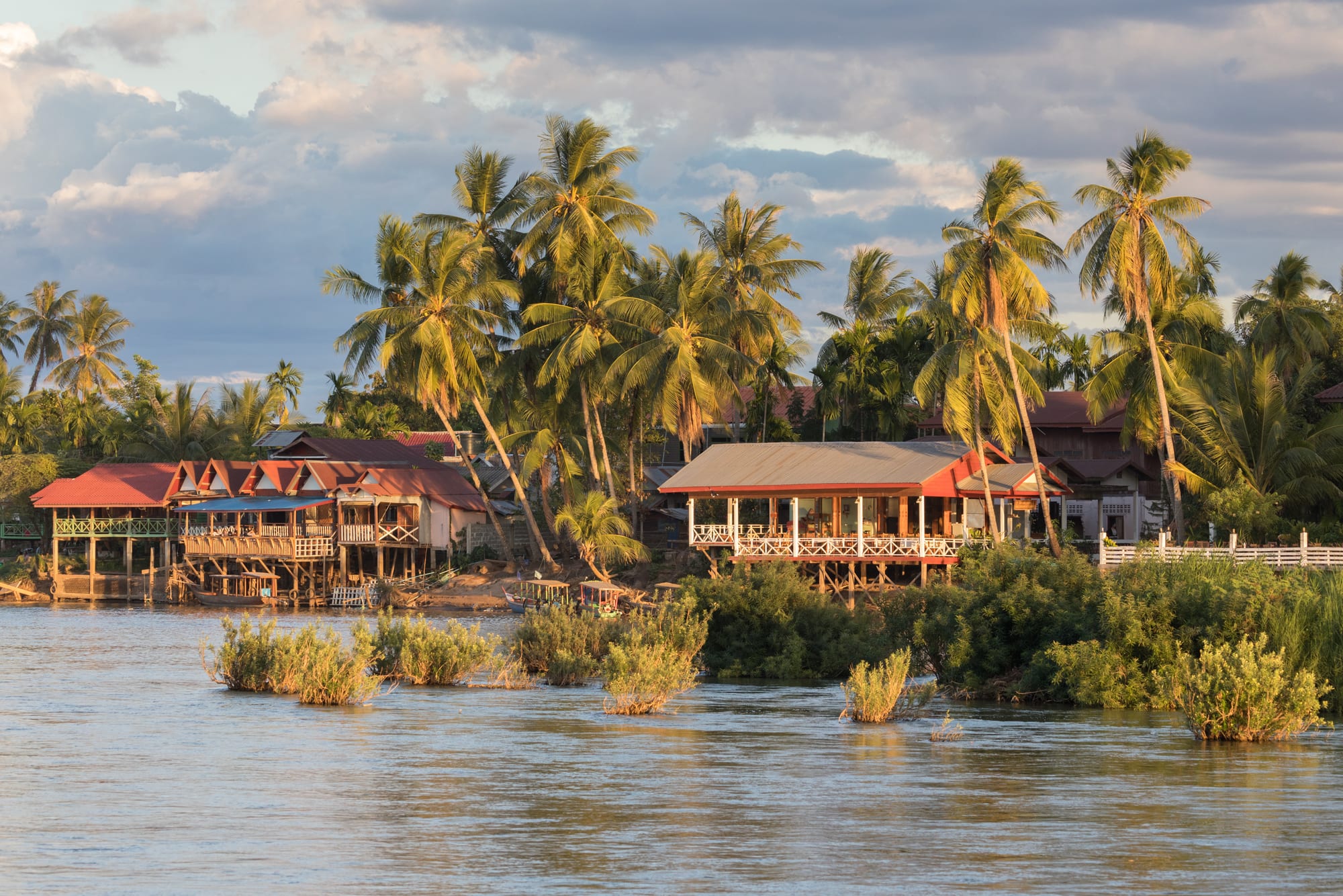
Wooden stilt houses with red roofs under tall coconut palms along a river bank in warm evening light

Pakse & the South, Laos

Si Phan Don

Stilt houses on the bank of Don Khon seen from Don Det, in the Four Thousand Islands. (Basile Morin / Wikimedia Commons · CC BY-SA 4.0)

A braided stretch of the Mekong in the far south of Laos, where the river spreads several kilometres wide around hundreds of wooded islands before dropping through the Khone falls into Cambodia. Its name means Four Thousand Islands. Don Khong, Don Det and Don Khon carry the villages, the ruins of a French portage railway and a long-standing traveller scene of riverside bungalows.

Neighbourhoods

  • Don Det
    • Budget travellers
    • Sunsets
    • Bars and hammocks

    The busiest island for visitors, with a northern tip of guesthouses, bars and boat landings and a quiet southern half of rice fields and buffalo tracks. Bungalows line both banks, and the sunset side draws people to the river in the late afternoon.

    Open in Maps
  • Don Khon
    • Quiet stays
    • Walks and cycling
    • Waterfalls

    Joined to Don Det by the old French railway bridge, and quieter and greener. Its paths lead past a village temple, sections of the abandoned railway and the rapids on the south-western shore.

    Open in Maps
  • Don Khong
    • Local life
    • Quiet and residential
    • Cycling

    The largest island, upstream from the others, with a small riverside town at Muang Khong, a handful of hotels and a flat ring road past paddy fields, temples and fishing villages. Far fewer visitors stay here.

    Open in Maps
  • Don Som and the smaller islands
    • Homestays
    • Getting away from it all

    Don Som is the second largest island of the group, and around it lie farming islands reached by local boat, where a few homestays and family guesthouses sit among gardens, palms and rice fields with almost no traffic.

    Open in Maps
  • Nakasang and the mainland bank
    • Transport
    • Markets

    The riverside village on the eastern bank where buses from Pakse meet the boats to the islands. Its market is the main supply point for the whole area and the place where island households shop.

    Open in Maps

Things to do

The river and its falls

  • Khone Phapheng Fallsattraction

    The rapids where the full weight of the Mekong pours through rock channels near the Cambodian border. At nearly 11 km from edge to edge they are the widest waterfall in the world, and the reason the river cannot be navigated upstream from Cambodia.

    Open in Maps
  • Li Phi Fallsattraction

    The Somphamit rapids on the south-western edge of Don Khon, where the river tears through boulders and fishermen set bamboo traps in the channels.

    Open in Maps
  • The Mekong channels and sandbarsattraction

    The wider river landscape of wooded islets, fish traps and seasonal sandbars, at its most open when the water drops in the dry months.

    Open in Maps

History and villages

  • The Don Det–Don Khon railwaylandmark

    The bridge, piers and trackbed of the narrow-gauge portage line the French laid from 1893 to carry cargo around the falls — the first railway in Laos, and the only one until 2009. The last steam locomotive left in the country stands under a shed at Ban Khon.

    Open in Maps
  • Muang Khongneighborhood

    The village on the eastern shore of Don Khong and the island's de facto capital and seat of regional government, with a French-era street, a temple and the boat landing.

    Open in Maps
  • Don Sahong Damlandmark

    A run-of-the-river hydroelectric dam of 260 MW at the downstream end of the Hou Sahong channel, less than two kilometres above the Cambodian border, commissioned in 2020 and much argued over for its effect on fish migration.

    Open in Maps

Walks, cycling and the water

  • The Don Khon path to the rapidstrail

    A flat track across Don Khon from the bridge to the south-western shore, passing the temple, the old railway cutting and river views.

    Open in Maps
  • Don Khong ring roadtrail

    A quiet surfaced lane around the largest island, 18 km long and 8 km across at its widest, cycled past rice fields, village temples and fishing hamlets.

    Open in Maps
  • Kayaking and boat trips on the Mekongattraction

    Local operators run paddling and longtail trips between the islands, around the channels above the falls and to riverside villages.

    Open in Maps

Short trips from the islands

  • Wat Phoulandmark

    The Khmer temple on its mountainside above the Mekong upstream at Champasak, a UNESCO World Heritage cultural landscape, reached as a long day trip or a stop on the way north.

    Open in Maps

Seasonal events

  • Boun Ork Phansa and the boat racesOctober

    The end of Buddhist Lent, when candle-lit floats are set on the Mekong and villages race long rowing boats in front of Muang Khong.

  • Pi Mai Laomid-April

    The Lao New Year, marked on the islands with water throwing, temple offerings and family gatherings in the hottest weeks of the year.

  • Boun Bang FaiMay

    The rocket festival, when bamboo rockets are fired from village grounds to call for rain before planting.

Eat and drink

Long-standing places and food districts in Si Phan Don. Hours, ratings and directions come from your maps app, always current.

Island classics

  • Riverside bungalow restaurants on Don Detneighborhood

    Wooden decks over the water serving grilled Mekong fish, laap, fried rice, fruit shakes and Beerlao, with menus that also stretch to pancakes and pasta for long-staying visitors.

    Open in Maps
  • Nakasang marketmarket

    The mainland market that supplies the islands — fresh and dried river fish, sticky rice, vegetables, fruit and noodle stalls for bus passengers waiting on a boat.

    Open in Maps
  • Noodle shops in Muang Khongneighborhood

    Small family kitchens along the Don Khong waterfront serving feu noodle soup in the morning and fish with sticky rice later in the day.

    Open in Maps

Experience Si Phan Don

History

The islands owe their shape to the Khone falls, the barrier of rapids at the southern end where the Mekong drops out of Laos. The falls made this stretch a frontier for centuries: boats could not pass, so goods were carried around them, and the villages lived from fishing, rice and the traffic that stopped here. The area lay within the Lao kingdom of Champasak, which came under Siamese control in the late 18th century.

French gunboats forced the issue in the 1890s. After taking the east bank of the Mekong in 1893, France tried to open the river as a trade route to China and found the falls impassable. A first line was laid across Don Khon in 1893 and a permanent narrow-gauge railway was in place by 1897; in the 1910s it was carried over a bridge to Don Det, making a portage line of about seven kilometres with piers at each end, where steamers unloaded and reloaded. It was the first railway in Laos and the only one until 2009. The last train is reported to have run in 1940; the bridge, embankments and a locomotive remain.

After 1975 the islands were a quiet corner of the new republic, living from fishing and farming. Travellers began arriving in numbers in the 1990s, and simple bungalows spread along the banks of Don Det and Don Khon, bringing guesthouses and a cash income to villages that had little of either. The Don Sahong dam, on the Hou Sahong channel just above the Cambodian border and operating since January 2020, has been the great local controversy: Cambodia, Vietnam and civil society groups objected to it through the Mekong River Commission, chiefly over its effect on the fish that the river's communities depend on.

Culture & Customs

Life here is village life on water. Households are organised around fishing, rice and family, the temple is the centre of each village, and the Buddhist calendar sets the year: alms rounds at dawn, ordinations in the dry season, and the end of Lent in October, when candle-lit floats are pushed out onto the Mekong and long boats race in front of Muang Khong. The southern Lao spoken on the islands is close to the speech of north-east Thailand.

Fishing traditions are unusually elaborate, because the falls create channels where fish concentrate. Villagers build bamboo traps and platforms into the rapids at Li Phi, repair them each season, and time their work to the migrations that move up and down the river. Irrawaddy dolphins once lived in the deep pool near the Cambodian border and were a point of local pride, though the species has been extinct in Laos since 2022.

Visitors have been part of the picture for thirty years, and the islands hold two rhythms at once: guesthouse bars and hammocks on one bank, a farming village with a monastery on the other. Islanders are tolerant of this but expect visitors to cover up away from the river and to keep noise down after dark. Greetings are made with palms together at the chest, shoes come off at a doorway, and voices stay low.

Daily Life

Only a few thousand people live on the main visited islands, within the wider Khong district that takes in the islands and part of the mainland bank to the east. Don Khong, which has nineteen villages, holds the seat of administration, the schools and the offices; Don Det and Don Khon live largely from guesthouses, restaurants and boats; the smaller islands are farming communities reached only by local boat.

Days start before dawn with nets and traps, alms for the monks, and the morning market at Nakasang or Muang Khong, and most work is done before the heat of the middle of the day. Families grow rice, keep buffalo, chickens and gardens of banana and coconut, and sell fish and vegetables across the water. Electricity arrived on the main islands in stages during the 2000s and 2010s, and mobile signal and internet are now normal, if patchy.

The pressures are those of a place that depends on one river and one trade. Catches have fallen, and dams upstream and at Don Sahong are blamed for changes in water level and fish numbers; the seasonal flood can damage paths and low bungalows; and younger islanders often leave for work in Pakse or across the border in Thailand. Tourism brings money but concentrates it on two islands, and the arrival of better roads and the bridge routes to Cambodia has slowly changed who stops here and for how long.

Food

The Mekong is the larder. Fish is eaten at nearly every meal: grilled whole over charcoal as ping pa, minced into laap pa with lime, chilli, herbs and toasted rice powder, steamed in banana leaf with dill and lemongrass as mok pa, or simmered in a sour soup. Smaller fish are fried crisp and eaten whole, and pa daek, the fermented fish paste that gives Lao cooking its depth, is made in jars in the villages. Everything is eaten with sticky rice, rolled into a ball by hand from a woven basket.

Beside it comes tam mak hoong, green papaya pounded with chilli, lime, garlic, palm sugar and fish paste, often fiercer here than versions served to visitors in the towns. Grilled chicken, bamboo shoot soup and stir-fried morning glory fill out a family meal, and jungle herbs and river weed appear in season. Breakfast is feu, a rice noodle soup with a plate of herbs, or khao jii, the baguette inherited from the French, split and filled.

Guesthouse kitchens add fruit shakes, fried rice, sandwiches and Western dishes for long-staying travellers, and the bars pour Beerlao by the bottle at sunset. Bolaven coffee from the plateau north-east of the islands is drunk strong and sweet over condensed milk, and lao-lao, the home-distilled rice spirit, comes out at weddings and festivals.

Planning tools

Budget

This is one of the cheapest places to stay in Laos. Simple bungalows with a hammock and a river view cost very little, meals are inexpensive, and the boat crossing from the mainland is a small fixed fare. Costs rise only for air-conditioned rooms, private boat hire and organised trips to the falls.

Daily Budget Midrange
USD 40–90 (better riverside room, restaurant meals, private boat trips and a guided excursion)
Daily Budget Shoestring
USD 12–25 (island bungalow, local meals, shared boats and a rented bicycle)

Cash machines are unreliable on the islands and absent on the smaller ones, so bring enough kip from Pakse or Nakasang.

Best Time to Visit

November to February is the most comfortable stretch, dry and warm, with the river falling and sandbars appearing. March to May is very hot. The rains from June to October raise the Mekong, hide the beaches and can flood low-lying paths, but the falls are at their most powerful and the islands are green.

Suggested Number of Days

Two or three days suit the pace here, which is slow by design. Longer stays are common among travellers who settle into a bungalow, and adding the upstream sights or a crossing into Cambodia stretches a visit to four or five days.

First Visit
2–3 days
With Surroundings
4–5 days

Transportation

Boats are the only way between the islands, either shared longtails leaving when full from Nakasang and Ban Hat Xai Khoun or private hire. Don Det and Don Khon are crossed on foot or by bicycle over the old railway bridge, and Don Khong has a bridge to the mainland and a flat ring road. Bicycles, and some motorbikes, are rented in the villages; there is no public transport on the islands themselves.

Agree boat fares before setting off, and expect paths on Don Det and Don Khon to be sandy or muddy rather than paved.

Airport & Station Connections

Most people come by minibus or bus from Pakse, the closest of the larger Lao cities, to the boat landing at Nakasang or to the bridge for Don Khong, then a short crossing to the islands. Buses also run from Savannakhet and Vientiane, and the Cambodian border lies a short drive south, with through services to Stung Treng and beyond. The nearest airport is Pakse.

Walkability

Everything on Don Det and Don Khon is walkable: the two villages, the bridge between them and the rapids are within a few kilometres, on flat sandy paths shared with bicycles, chickens and buffalo. There are no cars to speak of. Paths are unlit at night, uneven in places and slippery after rain, so a torch is useful.

Safety

The islands are calm and crime is limited to occasional theft from bungalows, which are often flimsy and unlocked. The serious risks are on the water: the Mekong runs fast and deep with whirlpools and rocks near the rapids, and drownings happen. Boats can be overloaded and rarely carry life jackets, and bicycle and motorbike falls on sandy tracks are common.

Swim only in calm, shallow places the villagers use, keep well away from the water above the falls, avoid night crossings, and lock valuables away rather than leaving them in a bungalow. Check current official travel advice before travelling.

Climate

A tropical climate at the hot southern end of Laos, with a long monsoon and a short cooler season. The Mekong changes the islands with it: low, clear and full of sandbars in the dry months, high and brown from July to September, when low paths can flood.

Summer
very hot before the rains, with April days often 34–38°C, then humid with heavy showers from June to October
Winter
dry and warm, generally 20–32°C from November to February, cooler on the river at night

Local Customs

Island life is Lao Buddhist and conservative in dress and manner, even where visitors are relaxed. Villages are small and everyone knows who is staying where; quiet behaviour and a smile go a long way.

Swimwear is for the river, not the village paths or shops; shoulders and knees should be covered at temples and shoes left outside; monks are not touched or handed things directly by women; permission is asked before photographing people or fishing families. Tipping is not expected.

Common Payment Methods

The Lao kip is the currency and cash is essential, with Thai baht and US dollars sometimes taken for rooms and tours. Cards are accepted almost nowhere, and the few cash machines, on Don Khong and at Nakasang, can be out of order or out of notes, so it is normal to arrive with enough cash for the whole stay.