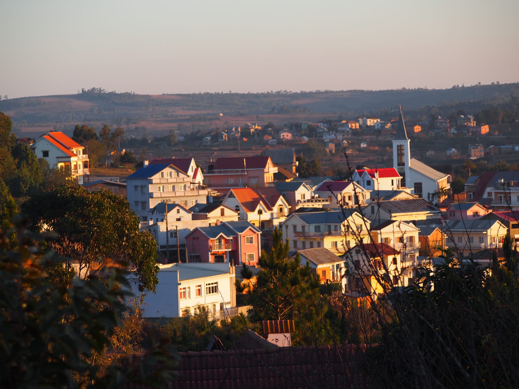
A hillside town of steep-roofed houses with red and blue tin roofs and a white church, in low evening light

Antananarivo & the Central Highlands, Madagascar

Ambatolampy

Ambatolampy at dusk, with the hills of the central plateau behind. (Lemurbaby / Wikimedia Commons · CC BY-SA 3.0)

A highland town on the RN7 about 70 kilometres south of Antananarivo, at the foot of the Ankaratra massif. It is known across Madagascar for its foundries, where cooking pots are cast from recycled aluminium in laterite moulds, and it serves as the road gateway to the cold forests and high peaks of Ankaratra.

Neighbourhoods

  • The RN7 through the town
    • First-time visitors
    • Close to transport
    • Shopping

    The main road doubles as the high street, lined with shops, craft stalls, eating houses and the stands where aluminium pots and pans are sold to passing traffic. Everything a visitor is likely to want is within a few hundred metres of it.

    Open in Maps
  • The market and foundry quarter
    • Crafts
    • Markets
    • Local life

    The lanes behind the main road, where the produce market trades and small workshops cast, hammer and polish aluminium in open yards. Sooty, noisy and the reason the town is known beyond the plateau.

    Open in Maps
  • The upper slopes and the road to Manjakatompo
    • Quiet and residential
    • Walks
    • Views

    Brick houses with balconies climbing the hillsides above the centre, giving way to eucalyptus and pine plantations, paddies and the track that heads west towards the Ankaratra forests.

    Open in Maps

Things to do

In the town

  • The aluminium foundriesattraction

    Open workshops where scrap metal is melted down and poured into moulds to make the cooking pots used across Madagascar, which the town supplies with most of its aluminium kitchenware; the same yards also work copper and bronze.

    Open in Maps
  • Ambatolampy marketmarket

    The town's produce market, supplied by the vegetable farms, dairies and paddies of the surrounding hills, busiest in the early morning.

    Open in Maps
  • Musee des Papillonsmuseum

    The town's butterfly museum, whose collection covers about 6,000 species of insects and butterflies.

    Open in Maps
  • The pot and pan stalls on the RN7market

    Rows of roadside stands selling the town's cast aluminium pots, ladles and pans, along with wrought iron and other highland crafts.

    Open in Maps

Hills and forests around the town

  • Ankaratra massiftrail

    The volcanic range rising west of the town, a landscape of high grassland, eucalyptus and pine plantations and patches of remnant forest, reached by rough tracks from the RN7.

    Open in Maps
  • Tsiafajavonaviewpoint

    The highest peak of the Ankaratra at about 2,640 metres and the third-highest in Madagascar, climbed in a long day from the tracks west of Ambatolampy; its name means where the mist never clears.

    Open in Maps
  • The Manjakatompo forest stationpark

    A forest station of some 8,300 hectares in the Ankaratra foothills west of the town, with planted pine and eucalyptus, streams and walking tracks in cool, often misty air.

    Open in Maps

Seasonal events

  • Independence DayJune

    The 26 June national holiday, marked with parades along the main road, music and lantern processions the evening before.

  • Famadihana seasonJune to September

    In the dry months highland families hold the turning of the bones, rewrapping ancestors in fresh silk shrouds; it is a private family rite, attended by invitation only.

  • Rice harvestApril and May

    The terraced paddies around the town turn gold and the market fills, the busiest weeks of the farming year on the plateau.

Eat and drink

Long-standing places and food districts in Ambatolampy. Hours, ratings and directions come from your maps app, always current.

Ambatolampy classics

  • Highland hotely canteensrestaurant

    Small eating houses along the RN7 serving rice with a laoka — romazava, ravitoto with pork, or beans — to drivers and market traders at a fixed low price.

    Open in Maps
  • Roadside grills and frittersmarket

    Stalls along the main road frying sambos and koba slices and grilling masikita, skewers of zebu, for passing taxi-brousse passengers.

    Open in Maps

Markets

  • Ambatolampy marketmarket

    Highland vegetables, fruit, rice, dairy and zebu meat from the farms around the town, with cooked-food stalls around the edges.

    Open in Maps

Experience Ambatolampy

History

Ambatolampy, whose name comes from vatolampy, a great rock, grew up in Imerina, the highland country of the Merina, whose rulers unified the plateau at the end of the eighteenth century from the royal hills to the north. Villages here farmed irrigated rice in the valleys and grazed the slopes of the Ankaratra, and the place was one of many market settlements on the routes running south from the royal capital.

Its modern shape dates from French rule. After the conquest of 1895 the colonial administration made Ambatolampy a district centre and drove the road that became the RN7 through it, connecting Antananarivo with Antsirabe and the far south; the railway between Antananarivo and Antsirabe gave the town a station on the line. The cool climate suited plantation forestry, and the hillsides west of the town were planted with pine and eucalyptus, while a forest station of several thousand hectares was established in the Ankaratra foothills at Manjakatompo.

The industry that made the town's name came later and from below. The first aluminium pots are said to have come out of a local workshop in 1951, cast in laterite moulds by a method borrowed from the old foundries Jean Laborde had run at Mantasoa, and the metal came from scrap — engine blocks, building materials, old cookware — melted down again. The trade grew through the second half of the twentieth century into dozens of family foundries, and Ambatolampy became the place the whole island buys its cooking pots. Road traffic on the RN7 does the rest: travellers between the capital and the south stop here, and the town lives on that passing trade as much as on its fields.

Culture & Customs

The town is Merina in language and custom, and the observances of the plateau shape the year: kabary, the formal oratory of proverbs delivered at weddings and funerals; hira gasy troupes who perform long programmes of song, dance and moral argument at village gatherings; and the famadihana in the dry season, when families open the tomb, rewrap their ancestors in fresh silk lamba and dance with them before reburial. The tombs themselves, built of stone and concrete, stand among the paddies and are more solid than many houses.

Craft is the local pride. The foundry trade is passed down within families, and the moulders, pourers and finishers each have their part in work that is done with very simple equipment and a great deal of skill. Along with pots, the workshops turn out ladles, pans and ornaments, and other households make wrought iron, baskets and embroidery for the roadside stalls.

Protestant and Catholic churches, an inheritance of nineteenth-century missions, fill on Sundays, and choirs are a serious matter. Fady, the taboos that differ from village to village, govern small things — which days to work, where not to walk — and are explained to visitors who ask. The manner of the town is quiet and formal; open argument in public is avoided, and business is done slowly.

Daily Life

Ambatolampy has roughly 30,000 people in the town itself, with many more in the farming communes around it. Houses of red brick with tiled or tin roofs and wooden balconies climb the slopes above the RN7, and rice terraces run right up to the edge of the built-up area. It is a district capital, with the offices, schools, clinic and market that go with the role.

Three things pay for the town: the foundries and their trade in cooking pots, farming — rice in the valleys, potatoes, carrots, beans and dairy on the higher ground, sold north to the capital — and the road. Lorries, taxi-brousse minibuses and tourist vehicles on the RN7 stop for fuel, food and pots, and a whole economy of stalls, canteens and repair yards has grown along the verge. Forestry in the hills adds a little more.

The day starts cold and early, with the market busy from first light and the foundry fires lit soon after. Midday is bright; by dusk the road traffic thins and the town is dark and quiet. The concerns are those of the plateau — the price of rice, power cuts, thin soil and erosion on the deforested slopes, and the charcoal burning that supplies the foundries and kitchens but eats into what forest is left.

Food

The food is highland Malagasy and unfussy. Rice is the meal, with a laoka alongside: romazava, the broth of beef and leafy greens with the mouth-numbing herb anamalao; ravitoto sy henakisoa, pounded cassava leaves cooked with pork; voanjobory, Bambara groundnuts stewed with meat; or beans and smoked fish in plainer households. Sakay, the fierce chilli paste, sits on the table, and ranovola, the smoky water boiled in the burnt rice pan, is drunk with the meal.

The cold uplands supply what the coasts cannot: potatoes, carrots, leeks, cabbage and tomatoes, along with milk, yoghurt and cheese from the dairy farms around the town.

Roadside eating is the town's speciality, since so much of its trade is with people passing through. Mofo gasy, small sweetened rice-flour cakes, are cooked in charcoal moulds before dawn; kitoza, strips of zebu smoked over a fire, goes with the morning rice porridge; and through the day stalls sell masikita skewers, sambos and slices of koba, the log of ground peanuts, sugar and rice flour steamed in banana leaf. Three Horses Beer from Antsirabe is the usual drink, and home-distilled toaka gasy belongs to family ceremonies.

Planning tools

Budget

Ambatolampy is inexpensive. Guesthouses and hotely meals cost little, and the main outlay for a visitor is transport — a place in a taxi-brousse from Antananarivo, or a hired car with driver for the tracks into the Ankaratra, which ordinary vehicles cannot manage. Aluminium pots and highland crafts are cheaper here than anywhere else on the plateau.

Daily Budget Midrange
USD 70–160 (comfortable hotel, restaurant dinners, a car with driver for day trips)
Daily Budget Shoestring
USD 15–30 (guesthouse room, hotely meals, taxi-brousse)

Bring cash: banking is limited here compared with Antananarivo or Antsirabe.

Best Time to Visit

April to November is dry and clear, and the only practical season for the tracks into the Ankaratra. The winter months of June to August are sunny by day and very cold at night, colder than anywhere else on the plateau. December to March brings heavy rain, mud and green paddies.

Suggested Number of Days

Half a day covers the town, which is small and often visited as a stop on the road south. A night or two makes sense for anyone walking in the hills to the west, where the tracks are slow and the weather can close in.

First Visit
Half a day
With Surroundings
1–2 days

Transportation

The town is small enough to cross on foot. Taxi-brousse minibuses stop on the RN7 through the centre and run north to Antananarivo and south to Antsirabe through the day, filling up as they go. Reaching the Ankaratra needs a four-wheel-drive vehicle with a driver, or a long walk from the end of the passable track.

Taxi-brousse seats to the capital are easiest in the morning; later in the day services fill up further north.

Airport & Station Connections

Ambatolampy sits on the RN7, roughly 70 kilometres south of Antananarivo and about two hours by road depending on traffic leaving the capital; Antsirabe is a further hour or so south. Nearly everyone arrives by taxi-brousse or by hired car on that road. The nearest airport with scheduled flights is Ivato at Antananarivo.

Walkability

Easy. The centre is a short stretch of the main road with the market and the foundries immediately behind it, all within a walk of fifteen or twenty minutes. Pavements are patchy and lorries use the RN7 through the middle of town, so the roadside needs care. The hills above are walkable but steep, and the forest tracks are long.

Safety

Outside Antananarivo the highlands are generally calm, and Ambatolampy is a quiet working town, though petty theft happens around the market and the taxi-brousse stops. The RN7 has a poor accident record, with lorries, pedestrians and carts sharing an unlit road. Political demonstrations concentrate in the capital rather than here, but national unrest can affect fuel supplies and road travel.

Carry little at the market, do not travel by road at night, and take a guide for the Ankaratra, where mist comes down quickly. Check current official travel advice before travelling.

Climate

High, cool and wetter than the towns further south, with the Ankaratra pulling cloud in from the west. The southern-hemisphere summer, December to February, is the rainy season, with warm days and long afternoon storms; the winter months of June to August are dry and bright by day and cold at night, with frost on the higher ground nearby.

Summer
warm and wet, about 15–26°C, with afternoon thunderstorms from November to March
Winter
dry and sunny by day, with highs around 20°C, and cold nights that can approach freezing, with frost on the massif

Local Customs

Greetings are unhurried and a handshake is usual; Malagasy is spoken everywhere and French is understood by many. Foundry owners are generally willing to let visitors watch a casting, but permission is asked first and a small payment or a purchase is the courteous return. Family tombs stand in the fields around the town and are private ground.

Ask before photographing people, workshops or tombs, dress modestly, and follow local guidance about fady, the taboos that vary from village to village.

Common Payment Methods

The currency is the Malagasy ariary, and the town runs on cash in small notes — market stalls, foundries, hotely meals and taxi-brousse fares are all paid that way. Banking and cash machines are limited compared with Antananarivo and Antsirabe, so money is best drawn or changed in one of those before arriving.