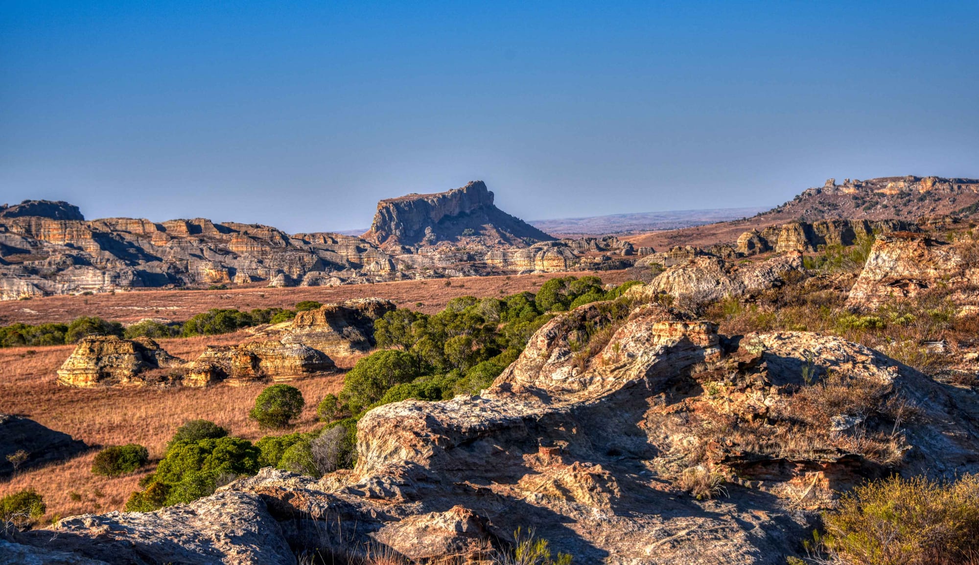
Eroded sandstone ridges and a flat-topped peak above dry golden grassland under a clear blue sky

Fianarantsoa & the Southern Highlands, Madagascar

Ranohira

The eroded sandstone of the Isalo massif, the protected landscape beside Ranohira. (Rod Waddington / Wikimedia Commons · CC BY-SA 2.0)

A small town on the RN7 in the dry grasslands of southern Madagascar, at the foot of the Isalo massif. It exists as the gateway to Isalo National Park, a ruined plateau of ancient sandstone cut by canyons, natural pools and palm-filled oases, and it lies in Bara cattle country a short way from the sapphire diggings of Ilakaka.

Neighbourhoods

  • The RN7 through the town
    • First-time visitors
    • Local life
    • Close to transport

    Ranohira is strung along the national road, with shops, stalls, small bars and the bush-taxi stop on either side of it. Almost all the town's business happens within a few hundred metres of the tarmac, and lorries and 4x4s pass through all day.

    Open in Maps
  • The park side of the village
    • Walks and viewpoints
    • Quiet

    The lanes running towards the massif hold the park office, guides' association and a number of small guesthouses, with the sandstone ridges filling the view. It is the quieter half of the town and the starting point for most walks.

    Open in Maps
  • The lodges on the road to Toliara
    • Views
    • Quiet and residential

    Several lodges stand a few kilometres out along the RN7 and on the tracks towards the massif, spaced well apart in open grassland with long views to the rock. They are reached by car rather than on foot from the town.

    Open in Maps

Things to do

Isalo National Park

  • Isalo National Parkpark

    A protected massif of eroded Triassic and early Jurassic sandstone created in 1962, with canyons up to 200 metres deep, natural pools, palm-filled gorges and ring-tailed lemurs, walked with local guides.

    Open in Maps
  • The Piscine Naturelletrail

    A natural pool fed by a waterfall in a pocket of pandanus and palms, reached on a hot walk over open rock from the park's nearest entrance.

    Open in Maps
  • The canyons of the massiftrail

    Narrow gorges cut into the sandstone, green with pandanus, palms and ferns along their streams, where ring-tailed lemurs come down to the water.

    Open in Maps
  • The Bara tombslandmark

    Bara and older Sakalava burial sites are set in the cliffs of several canyons; they are sacred, seen from a distance and not approached.

    Open in Maps
  • La Fenêtre de l'Isaloviewpoint

    A natural window weathered through a sandstone outcrop near the road west of the town, a standard stop for the view through it at sunset.

    Open in Maps

The town

  • The RN7 market stallsmarket

    Stalls along the national road sell fruit, dried fish, grilled maize and rough-cut gemstones to passing traffic.

    Open in Maps

Short trips from the town

  • Ilakakaattraction

    A town that grew from a hamlet into a sprawling settlement after sapphires were found nearby in 1998, its main street lined with buying offices.

    Open in Maps
  • Zombitse-Vohibasia National Parkpark

    A block of dry forest either side of the RN7, with eight lemur species, baobabs and ninety kinds of bird, among them the vulnerable Appert's tetraka.

    Open in Maps
  • Ihosyattraction

    The main town of the Bara plains north-east on the RN7, a cattle-trading centre at the junction of the road to Fort Dauphin.

    Open in Maps

Eat and drink

Long-standing places and food districts in Ranohira. Hours, ratings and directions come from your maps app, always current.

Eating in Ranohira

  • The hotely on the RN7neighborhood

    Small roadside eating houses serve rice with zebu, chicken or beans, and stronger, drier southern cooking than the highlands — the standard meal before or after a day on the massif.

    Open in Maps
  • The roadside stallsmarket

    Grilled maize, fried cassava, peanuts, mangoes in season and cold drinks sold to drivers and bush-taxi passengers stopping in the town.

    Open in Maps
  • Lodge dining roomsneighborhood

    The lodges spread along the RN7 cook set menus of zebu, river or sea fish brought up from the coast, and vegetables trucked in from the highlands.

    Open in Maps

Experience Ranohira

History

The Isalo massif has been part of Bara life far longer than the town below it. The Bara, cattle-herding people of the southern plains, used the sandstone plateau as pasture, refuge and burial ground, placing their dead in niches in the cliffs of its canyons, where they remain sacred sites today. Ranohira itself — the name is explained locally as the water of the makis, the ring-tailed lemurs said to have been found drinking at a spring here — was a settlement on the tracks across the plains, and grew when the colonial road that became the RN7 was pushed through from the highlands to Toliara.

Its modern role dates from 1962, when Isalo National Park was created over the massif, one of the earliest protected areas declared after independence. For decades that meant only a trickle of visitors, but as overland travel on the RN7 became the standard Madagascar itinerary, the park became the mainstay of the local economy, and the town acquired a park office, a guides' association, guesthouses and a line of lodges out along the road.

The other transformation came from the ground. In 1998 sapphires were found near Ilakaka, some 25 kilometres south-west on the RN7, and a rush followed: a hamlet became a sprawling town of diggings, buying offices and traders from across the Indian Ocean, with the wealth, lawlessness and environmental damage that accompany such booms. Ranohira absorbed some of that traffic and money, and industrial-scale mining now works in its commune as well, but the town remains what it has been since the road arrived — a stop on the way, living off what passes.

Culture & Customs

Ranohira is a Bara town at heart, and Bara custom governs much of what happens around it. Zebu are the measure of a family's standing, brought out for funerals and weddings and counted with care; cattle raiding, once a proof of a young man's courage before marriage, has long since hardened into the organised dahalo banditry that troubles the rural south. Funerals are the largest ceremonies, with cattle sacrificed and the dead eventually placed in the cliff tombs of the massif.

Those tombs make the park as much a cultural landscape as a natural one. Certain pools, caves and rock faces are fady — forbidden, or forbidden on particular days — and the guides, who are local, treat them as such and expect visitors to do the same. The park's rules and the community's taboos overlap, and both are explained before a walk starts.

The town's other culture is that of the road. The RN7 brings drivers, traders, overland travellers and the restless population of the sapphire fields, and Ranohira has the mixed, transient feel of a stop where nobody stays long — bars, stalls, repair shops and a stream of vehicles. Guiding has become a respected trade passed down within families, and the association that organises it is one of the more significant local institutions.

Daily Life

About sixteen thousand people live in the commune of Ranohira, in low houses of brick and thatch along and behind the national road. Cattle herding and small-scale farming of maize, cassava and rice in the wetter hollows are the traditional livelihoods, and the park is now the largest employer of young people, as guides, porters, cooks and lodge staff.

Water is the constant preoccupation, as it is across the south: the grassland dries hard between April and November, the streams that run in the canyons are the reliable supply, and drought years are hard on herds and harvests. Electricity is limited, the town has a hospital and schooling to junior secondary level, banks are in Ihosy or Toliara, and the sapphire diggings pull labour away in good seasons.

The rhythm is set by the road and the park. Guides leave at first light with walkers, bush taxis arrive unannounced, lorries stop for fuel and food, and in the evening the town gathers at stalls and bars along the tarmac. Out of the dry season the visitor traffic thins and the town returns to cattle, fields and the long empty view towards the massif.

Food

Southern Malagasy eating is drier and less rice-centred than that of the highlands. Maize, cassava and sweet potato carry weight here alongside vary, rice, and are boiled, pounded or grilled; the standard hotely plate is rice or cassava with a laoka of zebu, beans or dried fish, with sakay, chilli paste, to sharpen it. Zebu meat is everywhere in a cattle district, grilled over charcoal or stewed slowly with tomato and onion.

Milk and curds are traditional foods of the herding peoples, and sour milk is still drunk in the countryside around the town. Dried and salted fish comes up from the coast by lorry, tamarind flavours drinks and sweets, and roadside stalls sell grilled maize cobs, fried cassava, peanuts and mangoes in season to people waiting for a bush taxi.

Drinks are simple: sweet coffee, ranovola — the smoky water boiled off the toasted rice crust — bottled beer and toaka gasy, home-distilled rum. Lodge kitchens along the road cook a French-influenced menu of zebu fillets, fish brought up from Toliara and vegetables from the highlands, and pour the wines made in the hills around Fianarantsoa.

Planning tools

Budget

The town itself is cheap — simple guesthouses and hotely meals cost very little — while the lodges scattered along the RN7 are among the more expensive in southern Madagascar. Park permits and the compulsory guide, charged per group and per circuit, are the main fixed cost, with a porter and a vehicle transfer to the trailheads often added.

Daily Budget Midrange
USD 55–150 (lodge, park fees and guides, a car with driver)
Daily Budget Shoestring
USD 20–35 (guesthouse in the town, hotely meals, taxi-brousse)

Carry enough ariary in cash for permits, guides, porters and tips; banking in the town is minimal and the nearest reliable machines are in Ihosy or Toliara.

Best Time to Visit

April to October, the dry season, when the trails are firm and the days are clear; nights on the plateau are cold in June and July. The heat from November to March makes the long open sections of the walks hard going, and heavy rain can swell the streams in the canyons, though the grassland is at its greenest then.

Suggested Number of Days

One or two days is the usual stay, enough for the main walking circuits and the viewpoints along the road. Longer routes with a night camping in the massif, or a slower pause on the drive between the highlands and the coast, push the stay towards three days.

First Visit
1–2 days
With Surroundings
2–3 days

Transportation

The town is walked end to end in a few minutes and has no local transport. Trailheads lie several kilometres away on rough tracks, reached by the lodge's vehicle, a hired 4x4 or a lift arranged through the guides' association. Taxi-brousse services along the RN7 stop here between Fianarantsoa, Ihosy and Toliara, arriving at unpredictable hours.

Arrange the drive to the trailhead and the pick-up at the end of the walk when the guide is booked, as the finishing point is often not where the walk began.

Airport & Station Connections

Ranohira sits on the RN7 roughly 235 kilometres north-east of Toliara and about 90 kilometres from Ihosy, which places it a long day's drive from Fianarantsoa and two or three days from Antananarivo. Most visitors arrive in a hired car with driver; bush taxis pass through in both directions. Ihosy has a regional airport, and the airports with scheduled services are at Toliara and Fort Dauphin.

Walkability

The town is flat, small and easily walked, though the RN7 carries fast traffic through the middle of it. The park is another matter: the circuits cross bare rock and open grassland with little shade, with steep descents into the canyons, and they are demanding in the heat.

Safety

The main risks in the park are heat, dehydration and falls on rock, and walking is done with a guide in any case. Cattle-raiding dahalo gangs are active in the rural south, and highway robbery has occurred on the RN7 and the southern roads, particularly after dark. Buying gemstones from roadside sellers around Ilakaka carries a clear risk of fraud, and the trade is best left alone.

Madagascar has a long history of political unrest — mass protests in September 2025 were followed by a military takeover and a change of government, so demonstrations can disrupt movement in the capital. Travel the RN7 only in daylight with a reputable driver, carry plenty of water and sun protection on the walks, keep away from the tombs in the cliffs, and take local advice before going on to rural tracks. Check current official travel advice before travelling.

Climate

Hot, dry and open, on a plateau at about 800 metres between the highlands and the southern lowlands. Rain falls mainly in short heavy storms between December and March. Being in the southern hemisphere, summer runs from December to February and winter from June to August.

Summer
hot, roughly 20–33°C by day, with thunderstorms and the greenest grassland
Winter
warm days and cold nights, roughly 8–27°C, with clear skies and dry trails

Local Customs

This is Bara country, where cattle are wealth and status and funerals are the great family occasions. The tombs in the cliffs of the massif are sacred and strictly fady: they are not approached, pointed at or photographed at close quarters. Guides explain the local taboos that apply on each circuit, including places where water may not be entered and days when certain paths are not walked.

Ask before photographing people or zebu herds, dress modestly in the town, and treat the guides' instructions about sacred sites as binding.

Common Payment Methods

The currency is the Malagasy ariary and cash is essential. Park permits, guides, porters, stalls and guesthouses take cash only; the larger lodges may accept a card but should not be relied on. Cash machines in the town are unreliable, so money is usually drawn in Fianarantsoa, Ihosy or Toliara.