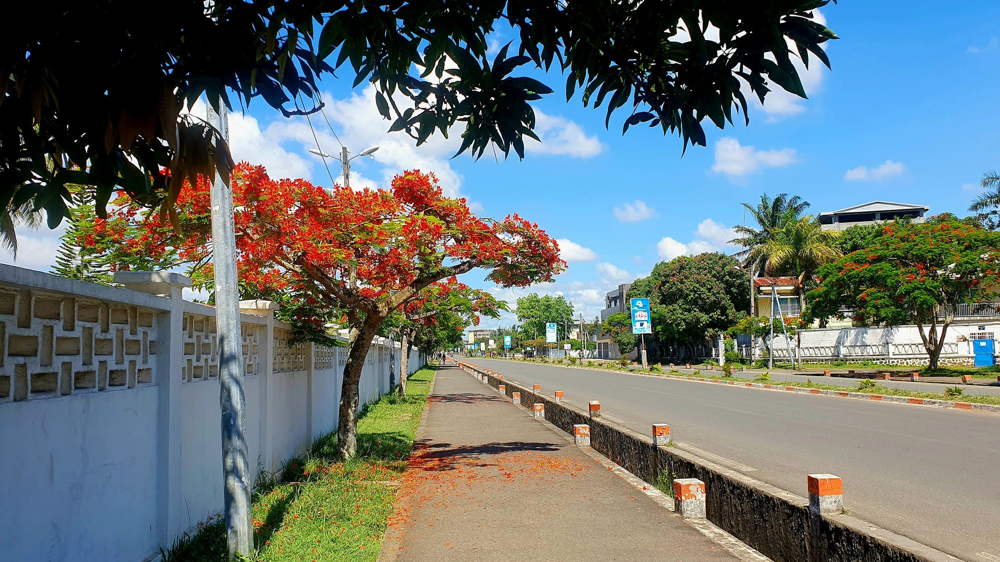
A wide, near-empty avenue lined with flame trees in red flower, palms and low white walls under a blue sky

Andasibe, Sainte-Marie & the East, Madagascar

Toamasina

Boulevard Labourdonnais, one of the broad tree-lined avenues of Toamasina. (Privatemajory / Wikimedia Commons · CC BY-SA 4.0)

Madagascar's main port, on the flat, wet east coast about a day's drive from the capital. Known in French as Tamatave, it became the Merina kingdom's window on the world in the nineteenth century and remains the country's trading gateway, a low city of broad avenues, flame trees, a long seafront and a busy market, with lagoons and beaches to the north and south.

Neighbourhoods

  • The seafront and the centre
    • First-time visitors
    • Evening walks
    • Close to restaurants

    The grid of broad avenues behind the beach, with hotels, banks, restaurants and colonial-era buildings among flame trees. The seafront boulevard runs beside the sand for a long stretch and is where the city walks, eats and meets after work.

    Open in Maps
  • The market quarter
    • Markets
    • Best for food
    • Local life

    The area around the big market inland from the seafront, dense with stalls, spice sellers, cheap eating houses and small shops. It is the commercial heart of the city and its noisiest, most crowded quarter.

    Open in Maps
  • The port district
    • Working waterfront
    • Industry

    The docks, container yards and warehouses that handle about 80 per cent of Madagascar's seaborne freight, together with the railway yards and the industrial estates behind them. Not a visitor area, but the reason the city exists.

    Open in Maps
  • The northern suburbs and beaches
    • Beaches
    • Quiet stays

    Beyond the port the city thins into suburbs and villages around the airport, with the road running north past beaches and lagoons towards Ivoloina and the coastal resorts. Quieter hotels and weekend places are found this way.

    Open in Maps
  • The southern quarters and the canal
    • Local life
    • Boats

    South of the centre are residential quarters and the start of the Pangalanes waterway, running towards the mouth of the Ivondro river, where boats and dugouts load for the lagoon villages behind the dunes.

    Open in Maps

Things to do

The city and the seafront

  • The seafront boulevard and beachlandmark

    A long palm-lined promenade beside the open Indian Ocean, busy in the late afternoon with walkers, football and food stalls; the surf and currents make swimming here unsafe.

    Open in Maps
  • The port of Toamasinatransit hub

    Madagascar's principal port, handling about 80 per cent of the country's seaborne freight, with cranes, container yards and ships visible from the coast road.

    Open in Maps
  • Toamasina railway stationtransit hub

    The coastal terminus of the colonial-era line up the escarpment to Antananarivo, a landmark of the port district and still in use for freight.

    Open in Maps

Parks and wildlife

  • Ivoloina parkpark

    A forestry station and zoological park about 12 kilometres from the city, with a lake, hiking trails and a dozen species of lemur, many donated by zoos or seized from illegal trade, run as a conservation and education centre.

    Open in Maps

The lagoons and the canal

  • Canal des Pangalanesattraction

    A chain of natural lagoons, lakes and dug channels running for hundreds of kilometres behind the east coast, travelled by boat and dugout past fishing villages and dunes.

    Open in Maps

Short trips from the city

  • Lake Ampitabepark

    A lake of abundant vegetation on the Pangalanes route, linked to its neighbours by small canals and fringed with traveller's palms.

    Open in Maps
  • Foulpointebeach

    A reef-sheltered beach town north of Toamasina, with calm water inside the reef and Fort Manda, a coral-built fort erected by the Merina king Radama I.

    Open in Maps
  • Mahambobeach

    A coastal village further north at the mouth of the Iazafo river, in farming country of rice, cloves and lychees.

    Open in Maps

Seasonal events

  • Commemoration of 29 Marchlate March

    A public holiday since 1967, remembering the uprising against French rule that began on the evening of 29 March 1947 in the east of the island, around Moramanga and Manakara.

  • Fête de l'Indépendance26 June

    Madagascar's national day, marking independence from France on 26 June 1960, celebrated with parades and public festivities.

Eat and drink

Long-standing places and food districts in Toamasina. Hours, ratings and directions come from your maps app, always current.

Toamasina classics

  • Chinese-Malagasy cookingrestaurant

    The city's long-established Chinese-Malagasy community gave the coast misao, fried noodles, and soupe chinoise, a noodle soup, both now everyday food sold in restaurants and street kitchens across town.

    Open in Maps
  • Seafront grills and stallsneighborhood

    Stalls along the promenade grill fish, prawns and zebu brochettes in the evening and sell coconut, fried cakes and juices to people walking the sand.

    Open in Maps

Markets

  • Bazary Bemarket

    The 'big market', a covered market a little more upmarket than the city's other bazaars, with smarter shops among the stalls; every quarter of Toamasina has its own market, known here as a bazary.

    Open in Maps
  • Bazary Kelymarket

    The 'little market' that, despite its name, is the largest in the city, selling food, cheap vegetables, clothes, household goods and Malagasy crafts to townspeople and to traders from other provinces.

    Open in Maps

Experience Toamasina

History

Toamasina grew on a sandy point where the reef gives a little shelter on an otherwise unforgiving coast. The surrounding country belonged to the peoples who became the Betsimisaraka, and the bays north and south of the town were used by British and American pirates from the 1680s to the 1720s. In the early eighteenth century Ratsimilaho, said to be the son of an English pirate and a Malagasy queen, united the coastal clans into the Betsimisaraka confederation, and the anchorage here became one of its trading points.

Radama I brought the coast under Merina rule in the 1810s and 1820s, and Toamasina became the kingdom's principal port and its point of contact with Europe: missionaries, merchants, consuls and arms all passed through it, and the town was fought over more than once in the conflicts of the nineteenth century. French forces bombarded and occupied it in December 1894 at the start of the second Franco-Merina war.

Under colonial rule, as Tamatave, it became the hub of the colony's economy. The railway from Antananarivo reached the coast here, the Pangalanes lagoons were linked by canals to give sheltered inland navigation, and a deep-water port was built in 1929 for the export of coffee, cloves, vanilla and lychees. The 1947 uprising against French rule began in the east of the island, around Moramanga and Manakara, in March of that year and was suppressed by early 1949, with estimates of Malagasy deaths ranging from 11,000 to more than 100,000. Since independence the city has lived by the port, which still handles most of Madagascar's seaborne freight, now with nickel and cobalt from the mine inland added to the older exports, and it has been struck repeatedly by cyclones: Cyclone Geralda destroyed much of the city in 1994, and Cyclone Gezani made landfall here in February 2026.

Culture & Customs

Toamasina is a port city and behaves like one: mixed, outward-looking and less formal than the highland capital. Its people are mainly Betsimisaraka, with Merina and Betsileo incomers, a Chinese-Malagasy community descended from migrants of the colonial era, Indian-descended traders, and a small European minority. That mixture shows in the shops, the churches, the temples and above all in the food.

Coastal Malagasy custom is strong beneath the city surface. Ceremonies for the razana, the ancestors, involve zebu sacrifice, rum and long nights of music; fady, the local prohibitions, vary between families and villages and are respected without much discussion. Catholic and Protestant churches are full on Sundays, and choirs are a serious business.

Music and the street are the city's pleasures. Bars and clubs along the seafront and in the centre play coastal dance styles and Malagasy pop, live bands are common at weekends, and the promenade fills every evening once the heat drops. Sport is football above all, played on the sand and on open ground across the city. The 1947 uprising, which began in the east of the island, is commemorated each March, and the city's identity as Madagascar's door to the world — Tamatave to older residents and to the French-speaking world — is a point of pride.

Daily Life

About 330,000 people lived in Toamasina at the 2018 census, making it the country's second-largest city. The centre is a colonial grid of wide avenues and flame trees near the sea; behind and around it are dense working quarters of timber and concrete houses, and the city spreads north towards the port, the industrial zones and the airport, and south towards the start of the canal.

The port dominates the economy, handling most of Madagascar's seaborne imports and exports, with the mineral pipeline and processing plant serving the nickel and cobalt mine inland, an oil refinery, food processing, and the trade in cloves, lychees, vanilla, coffee and pepper from the coast behind. Fishing, transport, commerce in the markets, and a university and hospitals employ many more; informal work and low wages are the reality for much of the population.

The day begins early, empties in the hottest hours and returns to the streets in the evening. Rain is a constant presence, low-lying quarters flood, and a serious cyclone can damage roofs, boats, crops and the port itself. Power and water supply are unreliable, as elsewhere in the country, and the road to the capital — the lifeline for goods landed here — is heavily used and often in poor repair.

Food

Toamasina eats rice with the sea and with coconut. Fish, prawns, crab, squid and lobster from the reef and the channel are grilled or cooked in coconut milk with ginger and tomato, and served as the laoka beside vary, the rice that anchors every meal. Fish from the Pangalanes lagoons also reach the markets, and greens, beans and cassava leaves fill out cheaper plates.

The Chinese-Malagasy community has left a strong mark on everyday eating here. Misao, fried noodles, and soupe chinoise, a broth of noodles with meat or seafood, are sold from street kitchens and restaurants all over the city and are part of urban popular cuisine wherever large Chinese communities settled. Samosas known as sambos, brochettes of zebu, grilled corn, fried cakes and mofo gasy rice cakes are the street staples.

Fruit is the coast's pride: lychees, which are exported through the port in large quantities, along with jackfruit, pineapple, mango, banana and rambutan. Cloves, vanilla, cinnamon and pepper from the country north of the city flavour both food and drink. To drink there is coconut water, strong sweet local coffee, betsabetsa, the traditional rum made from fermented sugarcane juice, Three Horses Beer, and rhum arrangé steeped with vanilla, lychee or ginger.

Planning tools

Budget

Toamasina is inexpensive by international standards: guesthouses and hotely meals cost little, mid-range hotels and restaurants are moderate, and the significant costs are hired vehicles and boat trips on the Pangalanes. It is one of the few places on the east coast with reliable cash machines.

Daily Budget Midrange
USD 80–180 (hotel, restaurant meals, a car with driver or a boat trip on the canal)
Daily Budget Shoestring
USD 25–40 (guesthouse, hotely meals, taxi-brousse and pousse-pousse)

Draw cash here before heading up the coast or onto the canal, and share boat excursions, which are priced per craft.

Best Time to Visit

September to November is the driest period on this coast. January to March is the cyclone season, with heavy rain and the risk of roads, flights and boats being disrupted for days.

Suggested Number of Days

Two days are enough for the city, its market and its seafront. Four or five allow the beaches north along the coast and a boat trip onto the lagoons behind the dunes. Weather and road conditions change the number more than anything else.

First Visit
2 days
With Surroundings
4–5 days

Transportation

Pousse-pousse and cyclo-pousse rickshaws are the city's own transport and cover most short journeys, alongside taxis and motorised tuk-tuks. Taxi-brousse minibuses leave from stations on the edge of town for the capital and up and down the coast, and a car with driver is the usual choice for excursions. Boats leave for the Pangalanes from points south of the city.

Agree the fare before setting off with a rickshaw or taxi, and do not travel the coast road or the highway to the capital after dark.

Airport & Station Connections

Toamasina's airport lies a few kilometres from the centre, with flights to Antananarivo and other regional airports. The national road from the capital, about 350 kilometres, takes most of a day by car or taxi-brousse through the escarpment forests. The railway from the highlands ends at the port, and cruise and cargo ships call at the harbour.

Walkability

The centre is flat, laid out on a grid of wide avenues, and the seafront, the market and most hotels are within a walk of each other. Distances feel longer in the heat and humidity, pavements are broken in places, and rickshaws fill the gap for anything further. The port, the airport and the northern beaches are too far to walk.

Safety

Toamasina is generally calm by day, and the recognised risks are theft and robbery at night, particularly on the unlit stretches of the seafront and around the market and port quarters. Swimming from the city beach is dangerous because of currents and sharks. Malaria is intense on this coast, and cyclones between January and March can flood the city and cut the roads; Cyclone Gezani made landfall at the city in February 2026 and destroyed some 25,000 homes.

Madagascar has a long history of political unrest — mass protests in September 2025 were followed by a military takeover and a change of government, so demonstrations can disrupt movement in the capital. Use a taxi rather than walking after dark, leave valuables in the hotel, swim only at reef-sheltered beaches where local people advise, take malaria precautions and follow cyclone warnings. Check current official travel advice before travelling.

Climate

Hot, humid and among the wettest parts of Madagascar, with rain in every month brought by the trade winds. The wettest months are February to April, the cyclone risk is highest between January and March, and the driest spell is usually September to November.

Summer
December to February is the southern summer: hot and humid, around 24–31°C, with heavy rain and cyclone risk
Winter
June to August is the southern winter: warm, around 18–24°C, with frequent showers and grey days

Local Customs

This is Betsimisaraka country, with Chinese-Malagasy and Indian-descended families long settled in the trading streets and a strong Christian presence alongside ancestral practice. The pace is slower and the manner more relaxed than in the highlands; greetings are unhurried and French is widely used in business. Fady, local taboos, vary by family and village, and tombs and burial places are treated with respect.

Dress modestly away from the beach, ask before photographing people, markets or the port, and round up a fare or a bill rather than tipping heavily.

Common Payment Methods

The currency is the Malagasy ariary and most transactions are in cash. Toamasina has banks and cash machines, unlike most of the coast, and larger hotels and some restaurants take cards; mobile money is widely used for small payments.