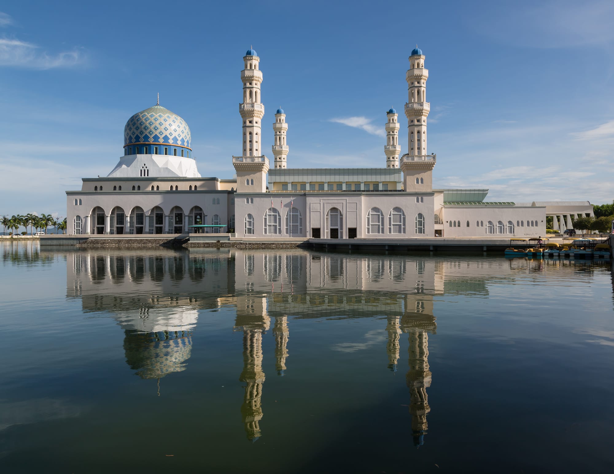
A white mosque with a blue and gold dome and four minarets reflected in still water under a blue sky

Sabah, Malaysia

Kota Kinabalu

The Kota Kinabalu City Mosque, built on a lagoon at Likas Bay. (CEphoto, Uwe Aranas / Wikimedia Commons · CC BY-SA 3.0)

The capital of Sabah, on the north-west coast of Borneo between the South China Sea and the Crocker Range. Founded as the British North Borneo port of Jesselton, destroyed in the Second World War and rebuilt from 1946, it is now the state's commercial and transport centre, with coral islands in sight of the seafront and the road to Mount Kinabalu running inland.

Neighbourhoods

  • The city centre and Gaya Street
    • First-time visitors
    • Best for food
    • Close to public transport

    The grid of post-war blocks between the hills and the sea, holding most of the hotels, the banks, the shophouse restaurants of Gaya Street and its Sunday market. Everything in the old core is within a short walk, and the buses and minibuses for the rest of the state leave from here.

    Open in Maps
  • The waterfront and Jesselton Point
    • Seafood
    • Sunsets
    • Boats to the islands

    The reclaimed strip along the sea front, with the fish, handicraft and night seafood markets, the ferry terminal for the islands and Labuan, and bars and restaurants facing the sunset. Busy from late afternoon until well into the evening.

    Open in Maps
  • Likas and Kampung Air
    • Local life
    • Quiet and residential

    North-east of the centre along the bay, with the City Mosque on its lagoon, the wetland reserve, sports grounds and residential blocks. Kampung Air, closer in, is a dense district of stilted and reclaimed housing, shops and eating places.

    Open in Maps
  • Tanjung Aru
    • Beaches
    • Families
    • Evening walks

    A long beach of pale sand and casuarina trees south-west of the centre, near the airport, with food stalls, a park and the state's busiest sunset promenade. Hotels and residential streets sit behind it, and the railway to the interior starts here.

    Open in Maps
  • Penampang and Donggongon
    • Local life
    • Markets
    • Best for food

    The Kadazan heartland immediately inland from the city, a separate town that has grown into the suburbs, with a large market, restaurants serving Kadazan-Dusun food and the main celebrations of the Kaamatan harvest festival.

    Open in Maps
  • Inanam and the northern suburbs
    • Close to public transport
    • Quiet and residential

    The spread of housing estates, shophouses and light industry along the road north, where the long-distance bus terminal for Sandakan, Tawau and the interior is located. Practical rather than scenic, and where much of the city actually lives.

    Open in Maps

Things to do

Landmarks and the waterfront

  • Kota Kinabalu City Mosquelandmark

    A white mosque with a blue-tiled dome opened in 2000 on the shore of Likas Bay, partly surrounded by a man-made lagoon that gives it the nickname of the floating mosque.

    Open in Maps
  • Sabah State Mosquelandmark

    The state mosque at Sembulan, completed in 1975 and officially opened in 1977, with a tall dome of gold mosaic and a minaret visible across the southern approaches to the city.

    Open in Maps
  • Atkinson Clock Towerlandmark

    A timber clock tower commissioned in 1905 on the hillside above the centre, the oldest standing structure in the city and one of the few to survive the wartime destruction of Jesselton.

    Open in Maps
  • Signal Hill Observatoryviewpoint

    A lookout on the ridge behind the old town, reached by steps or road, with a view over the city, the port and the islands offshore.

    Open in Maps
  • Jesselton Pointtransit hub

    The waterfront ferry terminal for the island boats and the Labuan ferry, with a jetty, shops and restaurants in the old harbour.

    Open in Maps

Museums and culture

  • Sabah State Museummuseum

    The state collection, set on a hill at Bukit Istana Lama, with ethnographic, natural history and archaeology galleries and an ethnobotanic garden, a zoo and a heritage village in its grounds.

    Open in Maps
  • Sabah Art Gallerymuseum

    The state art gallery near the museum complex, showing work by Sabahan and Malaysian artists in an octagonal basket-shaped building.

    Open in Maps
  • Tun Mustapha Towerlandmark

    A 30-storey glass tower of 1976 at Likas, with a revolving floor giving a view over the bay, built as the headquarters of the Sabah Foundation and renamed in 2001.

    Open in Maps

Markets

  • Gaya Street Sunday Marketmarket

    A street market that fills the main road of the old town every Sunday morning with plants, crafts, food, clothes, pets and Sabah coffee.

    Open in Maps
  • Kota Kinabalu waterfront marketsmarket

    The run of markets along the sea front — fish, produce, handicrafts and the evening seafood stalls where the catch is chosen and grilled to order.

    Open in Maps

Islands, parks and beaches

  • Tunku Abdul Rahman Parkpark

    A marine park of five islands lying 3 to 8 kilometres off the city, with beaches, coral, snorkelling and walking trails through coastal forest.

    Open in Maps
  • Gaya Islandbeach

    The largest island of the marine park, with forest trails, a long water village on its eastern side and resorts on its bays.

    Open in Maps
  • Tanjung Aru beachbeach

    The city's own beach, a long sandy strip lined with casuarinas and food stalls, where much of Kota Kinabalu watches the sunset.

    Open in Maps
  • Kota Kinabalu Wetland Centrepark

    Twenty-four hectares of mangrove at Likas, the last of the forest that once lined this coast, with boardwalks, mudskippers, crabs and migratory birds within the built-up city.

    Open in Maps

Short trips from the city

  • Kinabalu Parkpark

    The park around Mount Kinabalu, about 90 kilometres inland, inscribed in 2000 as Malaysia's first UNESCO World Heritage Site, with montane forest trails and botanical gardens at its headquarters.

    Open in Maps
  • Mount Kinabalutrail

    A granite massif of 4,095 metres, the highest mountain in Malaysia and in Maritime Southeast Asia, climbed over two days; a permit, a licensed guide and a booked mountain bed are required and daily places are limited.

    Open in Maps
  • Poring Hot Springsattraction

    Hot sulphur pools, a canopy walkway and forest trails on the far side of Kinabalu Park, near Ranau.

    Open in Maps
  • Tuaranneighborhood

    A town about 30 kilometres north with a weekly tamu market, a Chinese pagoda and the water village of Mengkabong nearby; the noodle dish Tuaran mee is named after it.

    Open in Maps
  • Kota Beludneighborhood

    A town below the Crocker Range known for its large Sunday tamu market and for the horsemanship of the West Coast Bajau.

    Open in Maps

Seasonal events

  • KaamatanMay, with the state holiday on 30 and 31 May

    The Kadazan-Dusun harvest festival, celebrated across the state and centred on Penampang just outside the city, with ceremonies, dancing, rice wine and the Unduk Ngadau pageant.

  • Chinese New YearJanuary or February

    Lion dances, lanterns and open houses in the Chinese districts, with Gaya Street and the temples at their busiest.

  • Malaysia Day16 September

    The anniversary of the 1963 formation of Malaysia, marked more strongly in Sabah than in the peninsula, with parades and state ceremonies.

  • Hari Raya Aidilfitriat the end of Ramadan

    The main Muslim festival, when mosques fill, families hold open houses and much of the city closes for several days.

Eat and drink

Long-standing places and food districts in Kota Kinabalu. Hours, ratings and directions come from your maps app, always current.

Kota Kinabalu classics

  • Waterfront seafood marketsmarket

    Fish, prawns, squid, crab and clams displayed on ice and cooked to order — grilled, steamed with ginger or fried with butter and garlic — at long tables by the sea.

    Open in Maps
  • Gaya Street coffee shopsneighborhood

    Old shophouse kitchens in the old town serving Tuaran mee, ngiu chap beef noodle soup, roast meats, kaya toast and Sabah coffee from early morning.

    Open in Maps
  • Gaya Street Sunday Marketmarket

    Street stalls selling local snacks, sticky-rice bamboo tubes, cakes, Tenom coffee and tropical fruit alongside the plants and crafts.

    Open in Maps

Local and Indigenous food

  • Penampang and Donggongon marketmarket

    The Kadazan heartland market inland from the city, where hinava, bambangan pickle, linopot rice parcels and jungle vegetables are sold.

    Open in Maps
  • Kampung Air eating housesneighborhood

    A dense district of Malay, Chinese and Filipino-influenced kitchens close to the centre, open late and known for grilled fish and noodle dishes.

    Open in Maps
  • Tanjung Aru food stallsneighborhood

    Beachside stalls selling satay, grilled chicken wings, fried noodles, coconuts and shaved ice to the evening crowds.

    Open in Maps

Experience Kota Kinabalu

History

The coast here was part of the Brunei sultanate's sphere, with Bajau and Kadazan-Dusun communities on the shore and the rivers, before the British North Borneo Chartered Company took over the administration of the territory in 1881. An early company settlement on Gaya Island was burned in 1897 during Mat Salleh's revolt, and the company moved to the mainland opposite, founding a new township in 1899 that was named Jesselton after Sir Charles Jessel, the company's vice-chairman. A railway was pushed inland to Beaufort and Tenom, and the port shipped rubber, tobacco and timber.

The Second World War destroyed the town. Japanese forces occupied North Borneo from 1942, the Jesselton revolt of 1943 was put down with heavy reprisals, and Allied bombing in 1945 left almost nothing standing apart from the Atkinson Clock Tower and a few other structures. When North Borneo became a British crown colony in 1946 the capital was moved from ruined Sandakan to Jesselton, and the town was rebuilt on reclaimed ground along the shore.

North Borneo joined Malaysia in 1963 as Sabah, and Jesselton was renamed Kota Kinabalu in 1967 after the mountain inland; it was declared a city in 2000. Since then it has grown quickly along the coastal strip and up the hills behind, with land reclamation for the waterfront, hotels and shopping centres in the centre, and housing estates spreading north and south. The city's growth has been accompanied by long-running arguments over Sabah's share of federal revenue, its rights under the 1963 agreement and the status of large migrant and stateless communities.

Culture & Customs

Kota Kinabalu is the meeting point of Sabah's communities. Kadazan-Dusun families dominate Penampang and the districts inland, Bajau and Suluk communities the coast and the water villages, Chinese Sabahans — mostly of Hakka descent — the shophouse trades, and Malay, Murut, Rungus, Filipino and Indonesian populations add to the mix. Christians, Muslims and others live side by side, mixed marriages are common, and the city's calendar carries Kaamatan, Chinese New Year, Christmas and Hari Raya in turn.

Kaamatan, the harvest festival held through May, is the state's great celebration, honouring the rice spirit with ceremonies, sumazau dancing, rice wine and the Unduk Ngadau pageant, and Penampang on the city's edge is its centre. Malaysia Day on 16 September, marking the formation of the federation in 1963, is observed here with a seriousness it does not always have in the peninsula.

Sabahans see themselves as distinct from peninsular Malaysia, speak a relaxed local Malay full of its own slang, and use English easily. The tone of the city is informal: coffee shops, markets, football and fishing, and a weekend habit of heading for the islands or up into the hills. Mount Kinabalu, visible from the city on clear mornings, is sacred to the Kadazan-Dusun as the resting place of the dead, and is treated as more than scenery.

Daily Life

About 500,000 people lived in the city at the 2020 census, and some 730,000 in the wider area, which spreads along the coast from Tanjung Aru through Likas to Inanam and inland to Penampang and Putatan. It is the largest city in Sabah and the state's centre of government, trade, health care and education, with the university on the coast north of the centre.

Work is in government, retail, construction, transport, the port and tourism, with palm oil, timber and oil and gas shaping the state economy beyond the city. Sabah remains one of the poorer Malaysian states despite those resources, and the gap between the coastal city and the rural interior is wide. Large migrant and stateless communities, many of Filipino or Indonesian background, live in the water villages and outer settlements, and their status is a permanent political question.

Daily life starts early, with markets before dawn and offices from eight, and slows in the afternoon heat before the seafront fills again in the evening. Traffic on the coastal road, water supply interruptions and power cuts are familiar complaints, as is the cost of housing near the centre. Weekends mean the tamu markets in the surrounding towns, church or mosque, and boats out to the islands.

Food

Kota Kinabalu eats seafood first. The waterfront markets display the day's catch — prawns, squid, grouper, crab, clams and the sought-after tiger prawns — to be grilled over charcoal, steamed with ginger and soy, or fried with butter and curry leaves, and eaten at long communal tables. Chinese kitchens dominate that trade, as they do the city's noodles.

The local dishes are worth seeking out. Tuaran mee, named after the town to the north, is a springy hand-made egg noodle fried with char siu, egg and greens; ngiu chap is a clear beef noodle soup with sliced beef, tripe and tendon; and sang nyuk mien, pork noodle soup, is a standard breakfast. From the Kadazan-Dusun come hinava, raw fish cured in lime juice with ginger, shallots, chilli and grated bambangan seed; pinasakan, fish braised with sour fruit and turmeric; linopot, rice mixed with tapioca or yam and wrapped in leaves; and tapai and lihing, the rice wines drunk at festivals.

Coffee is a local point of pride: Tenom coffee, roasted in the interior, and the thick local kopi served in shophouses from Gaya Street outwards. Sabah tea grows near Ranau, and vegetables and milk come down from Kundasang. Street snacks include sticky rice roasted in bamboo, grilled chicken wings sold by the dozen at Tanjung Aru, and the fruit of the season — durian, langsat, bambangan and, briefly, the wild red-skinned tarap.

Planning tools

Budget

The city itself is inexpensive — hostels, street food and shophouse meals cost little — but the reasons most people come are not. Island boats and park fees, guided wildlife trips, diving, domestic flights and the Kinabalu climb, which needs a permit, a guide and a booked mountain bed, are the real budget. Prices rise in the dry months and at festivals.

Daily Budget Midrange
USD 85–200 (hotel, seafood dinners, guided trips or diving, a domestic flight)
Daily Budget Shoestring
USD 25–45 (hostel bed, market and shophouse meals, minibuses, a public boat to the islands)

Book the Kinabalu climb and island resort stays well ahead, as daily numbers on the mountain are capped, and compare package prices for wildlife trips further east.

Best Time to Visit

March to September is generally the driest and clearest period, best for the islands, for diving and for the mountain. Rain falls in every month and is heaviest from about October to January, when the sea can be rough and the east-coast rivers flood. The Kaamatan harvest festival fills May with celebrations across the state.

Suggested Number of Days

Two or three days covers the city, its markets and the islands offshore. Anyone continuing to the mountain, the rivers or the east coast should allow the better part of a week or more, since distances in Sabah are long and trips are usually sold in fixed blocks.

First Visit
2–3 days
With Surroundings
5–8 days

Transportation

The old town is walkable, and taxis and ride-hailing cover the rest of the city cheaply. Minibuses and vans run to Penampang, Tuaran, Kota Belud and the nearer districts from terminals in and beside the centre, and long-distance buses to Sandakan, Tawau and the interior leave from Inanam to the north along the Pan Borneo Highway. Boats to the marine park islands leave from Jesselton Point, and a railway runs south from Tanjung Aru towards Tenom.

Hiring a car makes the Crocker Range, the coast and the Kinabalu road far easier; for the east of the state, flying is usually quicker than driving.

Airport & Station Connections

Kota Kinabalu International Airport, the second busiest in Malaysia, is about seven kilometres south-west of the centre, a short drive by taxi, with flights from Kuala Lumpur, Singapore, and cities in East Asia, as well as to Sandakan, Tawau, Lahad Datu and Labuan. Ferries run to Labuan from Jesselton Point. Most Western passport holders enter visa-free for up to 90 days and must complete a Malaysia Digital Arrival Card before travelling. Sabah operates its own immigration control, and passports are checked and stamped on arrival even from Peninsular Malaysia.

Walkability

The centre is flat and compact: the old town, the waterfront markets and the ferry terminal are all within about 20 minutes on foot. Beyond that the city sprawls along the coast on wide roads with broken pavements and heavy traffic, and the heat, humidity and sudden downpours make longer walks hard. Signal Hill is a steep climb of steps from the centre.

Safety

Kota Kinabalu and the west coast are safe, with bag-snatching, traffic and opportunistic theft the ordinary risks. The specific concern in Sabah lies far to the east: the islands and waters off Semporna, Lahad Datu and Sandakan have a history of kidnapping by armed groups from the southern Philippines, and a security zone operates there. Sea conditions, strong sun and mountain weather on Kinabalu are the other practical hazards.

Use licensed operators for boats and dives, and climb Kinabalu only with a park-licensed guide and a permit. Check the latest advice before booking any island or dive trip off eastern Sabah, wear bags on the traffic-free side, dress modestly around mosques and in the religious east-coast states, and note that drug trafficking carries a mandatory death penalty. Check current official travel advice before travelling.

Climate

Hot and humid all year, with rain in every month and no true dry season. Sabah lies south of the typhoon belt, which gave it the name 'Land Below the Wind', and temperatures at sea level vary little; the mountains inland are far cooler.

Summer
hot and humid from March to September, generally 24–32°C, with afternoon showers and calmer seas
Winter
wetter from about October to January, 23–31°C, with heavier rain, rougher seas and occasional flooding

Local Customs

Sabah mixes faiths and communities more easily than the peninsula, and dress codes are relaxed by Malaysian standards, though modest clothing is expected in mosques and government offices and beachwear belongs on the beach. Alcohol is sold openly. Kadazan-Dusun, Bajau, Murut, Chinese and Malay communities all live in the city, English is widely spoken, and Sabahans are quick to distinguish their state from 'Malaya'.

Ask before photographing people, water villages or ceremonies, remove shoes when entering homes and places of worship, and treat Mount Kinabalu with respect, as it is sacred to the Kadazan-Dusun.

Common Payment Methods

The currency is the Malaysian ringgit. Cards and Malaysian mobile payment apps work in hotels, malls and larger restaurants, and cash machines are easy to find in the city. Markets, stalls, boats, minibuses and island and village businesses want cash, and services thin out quickly outside the main towns.