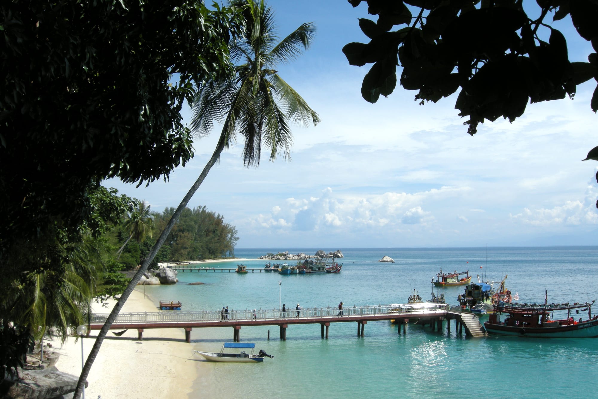
A wooden jetty reaching into turquoise water at a white sand beach, with fishing boats moored alongside and palms and forest on the shore

The East Coast, Malaysia

Perhentian Islands

The jetty and moored boats on the west side of Perhentian Besar. (Vyacheslav Argenberg / Wikimedia Commons · CC BY 4.0)

A pair of small forested islands in the South China Sea about 20 kilometres north-east of Kuala Besut on the Terengganu coast, reached by boat from the mainland jetty at Kuala Besut. Long a stopping place for fishermen and traders, the islands now live on snorkelling, diving and beach chalets, with no roads, no cars and a single fishing village on the smaller island.

Neighbourhoods

  • Long Beach, Perhentian Kecil
    • Backpackers
    • Nightlife
    • Beaches

    The long east-facing sand strip on the smaller island, lined with budget chalets, dive shops and beach cafés. It is where most younger and independent travellers stay, and the only place on the islands with much noise after dark. The surf can be strong here when the wind turns.

    Open in Maps
  • Coral Bay, Perhentian Kecil
    • Quiet and residential
    • Snorkelling
    • Sunsets

    The west-facing bay opposite Long Beach, a ten-minute walk across the island on a concrete path through forest. It is calmer, shallower and better sheltered, with a small jetty, a handful of chalets and restaurants, and the sun setting over the water.

    Open in Maps
  • Kampung Pasir Hantu
    • Local life
    • Quiet and residential

    The fishing village on the south-east corner of Perhentian Kecil, with stilt houses, a mosque and a school. It is the only permanent settlement on the islands and has very little tourist accommodation, though boats call at its jetty through the year, including in the monsoon months.

    Open in Maps
  • The west beaches of Perhentian Besar
    • Families
    • Mid-range resorts
    • Beaches

    A run of small sandy bays separated by rocky headlands on the larger island, with mid-range resorts, a dive centre or two and quieter evenings. Short but sometimes steep paths link one bay to the next, and water taxis cover the rest.

    Open in Maps
  • Teluk Dalam
    • Seclusion
    • Beaches

    A wide, shallow bay on the southern side of Perhentian Besar, further from the jetties and reached mainly by boat. A few larger resorts sit along it, and the water is calm, with reef and seagrass close to shore.

    Open in Maps

Things to do

Beaches and the water

  • Long Beach (Pasir Panjang)beach

    The main east-facing beach of Perhentian Kecil, a broad arc of pale sand backed by chalets, with clear water and reef at both ends.

    Open in Maps
  • Coral Baybeach

    A sheltered western bay on Perhentian Kecil with shallow coral close to the shore and a sunset view over the sea.

    Open in Maps
  • Teluk Dalambeach

    The long shallow bay on the south side of Perhentian Besar, quieter than the west-coast beaches and good for easy swimming.

    Open in Maps
  • The turtle nesting beachesbeach

    Quiet stretches of sand where green and hawksbill turtles come ashore to nest; the Department of Fisheries runs a hatchery on the islands to protect the eggs.

    Open in Maps

Snorkelling and diving

  • Pulau Rawaattraction

    A small uninhabited islet west of Perhentian Kecil, ringed by shallow coral and a standard stop on snorkelling trips.

    Open in Maps
  • The reefs and dive sitesattraction

    Fringing coral around both islands and the outlying islets, with blacktip reef sharks, sea turtles, cuttlefish and blue-spotted rays, worked by the dive schools on Long Beach, Coral Bay and Perhentian Besar.

    Open in Maps

Walks and viewpoints

  • The cross-island path, Perhentian Keciltrail

    A short concrete and jungle path linking Long Beach with Coral Bay, passing monitor lizards, macaques and forest on the way.

    Open in Maps
  • The Perhentian Besar coastal trailstrail

    Rough paths over the headlands between the island's western bays, with steps, roots and views down onto the reef.

    Open in Maps

Short trips from the islands

  • Kuala Besuttransit hub

    The mainland fishing town and jetty on the Terengganu coast where the speedboats to the islands start and finish.

    Open in Maps
  • Redang Islandattraction

    A larger island to the south with a marine park of its own and a more upmarket, resort-based character, reached from Merang or the Shahbandar jetty at Kuala Terengganu rather than directly.

    Open in Maps

Seasonal events

  • The monsoon closureroughly November to February

    The north-east monsoon brings heavy rain and rough seas, resorts and ferry services stop, and only the daily boat serving the fishing village on Perhentian Kecil keeps running.

  • Turtle nestingthe calm months between the monsoons

    Green and hawksbill turtles come ashore to lay on the quieter beaches, and the Department of Fisheries hatchery takes in eggs to protect them.

  • School holidays and long weekendsMalaysian school breaks and public holidays

    Chalets and resorts fill with domestic visitors, the boats from Kuala Besut are at their busiest and rooms are hardest to find.

Eat and drink

Long-standing places and food districts in Perhentian Islands. Hours, ratings and directions come from your maps app, always current.

Island eating

  • Long Beach chalet restaurantsneighborhood

    Open-sided kitchens attached to the chalets serve nasi goreng, roti canai, grilled fish and Western breakfasts, with tables set on the sand in the evening.

    Open in Maps
  • Coral Bay's beachfront kitchensneighborhood

    A short row of simple restaurants and a couple of small shops beside the jetty, quieter than Long Beach and facing the sunset.

    Open in Maps
  • Barbecue stalls on the beachmarket

    In the evenings several places lay out the day's fish, squid and prawns on ice and grill them to order with rice and salad.

    Open in Maps
  • Kampung Pasir Hantuneighborhood

    The village has a few warungs and shops selling rice dishes, noodles, snacks and cold drinks at mainland prices rather than resort ones.

    Open in Maps

Experience Perhentian Islands

History

The name Perhentian means "stopping place" in Malay, and that is what the islands were: a sheltered anchorage on the trading route between the Malay peninsula and Bangkok, where boats waited out weather, took on fresh water and traded. Fishing families settled the south-east corner of the smaller island, building the stilt village of Kampung Pasir Hantu, and for centuries the islands had no other permanent population. They fell under the sultanate of Terengganu, which paid tribute to Siam until the Anglo-Siamese Treaty of 1909 brought the state into British influence.

The wider coast has seen more upheaval than the islands themselves. The Japanese invasion of Malaya began with landings at Kota Bharu, a little way up this shore, on 8 December 1941, and from 1978 the main camp for Vietnamese boat people reaching Malaysia was on Bidong Island down the Terengganu coast, which held tens of thousands of refugees before closing in 2005.

Tourism came late. Backpackers reached the islands in numbers from the 1980s and 1990s, when simple chalets appeared on Long Beach and Coral Bay. The surrounding waters were gazetted as a marine park in 1994, banning fishing within two nautical miles of the shore and requiring a conservation fee from visitors. Development since has been piecemeal — generators, water shortages, rubbish and the lack of a proper sewage system are long-running problems — and the islands still close almost completely each monsoon, emptying of visitors and of most of the seasonal staff who work there.

Culture & Customs

The islands' permanent community is Malay and Muslim, and life in Kampung Pasir Hantu follows the rhythms of a Terengganu fishing village: the call to prayer, boats in and out, the mosque on Friday, children walking to the village school. Most of the people who serve visitors, however, are seasonal: dive instructors, boatmen, cooks and chalet staff who come from the mainland or from abroad for the open months and leave when the monsoon arrives, so the population and the atmosphere change completely between May and December.

That gives the islands two overlapping cultures. On the beaches the tone is informal and international, with English the common language, barefoot restaurants, beach fires and late music at the Long Beach end of Perhentian Kecil. A few hundred metres away, village norms apply, and visitors are expected to cover up and behave accordingly. Alcohol is available at some resorts but is not openly sold in the village, and during Ramadan eating and drinking in public during daylight is avoided out of courtesy.

Diving and marine conservation shape much of the islands' identity. Volunteer projects monitor reefs, plant coral fragments and protect turtle nests, and campaigns against single-use plastic and for better waste handling are visible on noticeboards and in the shops. Turtles, reef sharks and the state of the coral are the subjects most talked about.

Daily Life

Only a small permanent population lives on the islands through the year, nearly all of it in the fishing village on Perhentian Kecil, and the number swells with seasonal workers between March and October. There are no cars, no roads between beaches and no through traffic; goods, fuel, drinking water and building materials all arrive by boat from Kuala Besut, which is why a bottle of water costs more here than on the mainland.

The economy is almost entirely tourism and fishing. Chalets, dive schools, restaurants, snorkelling trips and water taxis employ most working-age islanders and a large seasonal workforce; the village keeps its fishing boats, and the catch supplies both households and restaurants. Electricity comes largely from generators with limited hours in the cheaper places, mobile coverage varies from beach to beach, and fresh water is a recurring constraint in dry spells.

The day starts early, with boats leaving for dive sites and snorkelling trips in the morning and returning by mid-afternoon; evenings are for eating on the sand. When the monsoon sets in around November most businesses board up, staff go home and the village returns to itself until the seas calm again. Rubbish, sewage and the pressure of visitor numbers on the reefs are the issues most often raised by residents and conservation groups alike.

Food

Eating on the Perhentians is simple and repetitive, and nobody pretends otherwise: the kitchens attached to chalets and resorts cook a short menu of Malay staples and traveller favourites, because everything except fish has to come over by boat. Nasi goreng and mee goreng, fried rice and noodles with egg, chicken or seafood, appear everywhere, along with roti canai and curry at breakfast, chicken or fish with rice, and banana pancakes, toasties and fruit shakes for visitors.

Seafood is the exception and the strength. In the late afternoon several restaurants set out the day's catch — snapper, barracuda, squid, prawns and occasionally lobster — priced by weight and grilled over charcoal with butter, garlic, chilli or a sweet-sour sambal, served with rice and cucumber. The Terengganu mainland's specialities reach the islands in a simplified form: keropok lekor, the chewy fish sausage fried and dipped in chilli sauce, is sold as a snack, and nasi dagang, coconut rice with tuna curry, sometimes turns up at breakfast in the village.

Alcohol is limited, not cheap and served only at certain resorts and bars; soft drinks, fresh coconuts, iced Milo and teh tarik, the pulled sweet milk tea, do most of the work instead. Village warungs sell rice dishes and snacks at mainland prices, and small shops carry biscuits, instant noodles and bottled water.

Planning tools

Budget

Everything on the islands has to arrive by boat, so food, water and drinks cost noticeably more than on the mainland, and the boat transfer and the marine park fee are fixed extras. Accommodation ranges from very basic fan chalets to comfortable air-conditioned resorts, and diving or a snorkelling trip is the other main expense. Prices rise steeply in the peak months and during Malaysian school holidays.

Daily Budget Midrange
USD 60–130 (air-conditioned resort room, seafood dinners, boat transfers, a day of diving)
Daily Budget Shoestring
USD 25–50 (fan chalet or dorm bed, rice and noodle meals, a shared snorkelling trip)

Bring enough cash for the whole stay — cash machines on the islands are scarce or out of service, and many places do not take cards.

Best Time to Visit

March to October, with the calmest seas and clearest water for diving from about April to August. The north-east monsoon runs from about November to February, bringing heavy rain and rough seas; most chalets, resorts and boat services close for that period and the islands are effectively shut. Weekends and Malaysian school holidays are the busiest times.

Suggested Number of Days

Three or four days suits most visitors, allowing for weather, a snorkelling trip and time on the sand. Divers working through a course or a series of sites need a week. Boat timings mean the arrival and departure days are largely taken up by travel.

First Visit
3–4 days
With Surroundings
5–7 days

Transportation

There are no roads and no cars. Movement between beaches is on foot along short jungle and headland paths, or by the small water taxis that run on demand from every jetty and beach and are the usual way to cross between Kecil and Besar. Speedboats from Kuala Besut serve both islands, dropping passengers at jetties or, on some beaches, wading distance from shore.

Agree the fare with a water taxi before getting in, and ask about the last crossing of the evening, as boats largely stop running after dark.

Airport & Station Connections

The islands are reached by speedboat from the jetty at Kuala Besut in Terengganu, a crossing of roughly half an hour. Kuala Besut is about 45 kilometres by road from Kota Bharu and its airport, and further from Kuala Terengganu; both airports have flights from Kuala Lumpur. Boats run to a timetable in the season and stop in the monsoon months.

Walkability

Each beach is walkable end to end in minutes, and the cross-island path between Long Beach and Coral Bay takes about ten to fifteen minutes. Beyond that, walking is limited: the trails over the headlands are steep, rooty and slippery after rain, there is no lighting at night, and most journeys of any length are made by boat. A torch is genuinely useful.

Safety

The islands are very safe in terms of crime. The real hazards are in the water and the forest: currents and sudden drop-offs at some beaches, boat traffic close to swimming areas, sunburn, sandflies and mosquitoes, and slippery trails. Medical facilities on the islands are very limited, and serious cases are taken to the mainland by boat.

Swim within marked areas where they exist, wear a life jacket on boats, and carry basic first aid and any medicines needed, as supply on the islands is limited. Dress modestly away from the beach in this religious east-coast state, and note that drug trafficking carries a mandatory death penalty in Malaysia. The specific caution is eastern Sabah: the UK government advises against all but essential travel to all islands and dive sites off the coast of eastern Sabah, from Sandakan to Tawau, because of the threat of kidnapping; mainland Sabah is not included in that warning. Check current official travel advice before travelling.

Climate

Hot, humid and tropical all year, with sea temperatures warm enough to swim without a wetsuit. The dividing line is the north-east monsoon, which brings the rain and the wind that close the islands for several months.

Summer
hot and humid, generally 26–33°C, with calm seas and short afternoon showers from March to October
Winter
the monsoon from about November to February brings heavy rain, strong winds and rough seas; temperatures stay around 24–30°C

Local Customs

The islands belong to Terengganu, a conservative Malay and Muslim state, and Kampung Pasir Hantu is a working village. Beachwear belongs on the beach: covered shoulders and knees are expected in the village, around the mosque and on the boats. Alcohol is served in some resorts but is not widely available and is not sold in the village. Tipping is not expected.

Ask before photographing villagers or their houses, do not touch or stand on coral, and take rubbish back to the mainland where possible, as waste disposal on the islands is difficult.

Common Payment Methods

The currency is the Malaysian ringgit. Cash is the practical means of payment on the islands: cash machines are few and sometimes empty, card terminals depend on a mobile signal, and smaller chalets and warungs take cash only. Most visitors draw what they need in Kota Bharu, Kuala Terengganu or Kuala Besut before crossing.