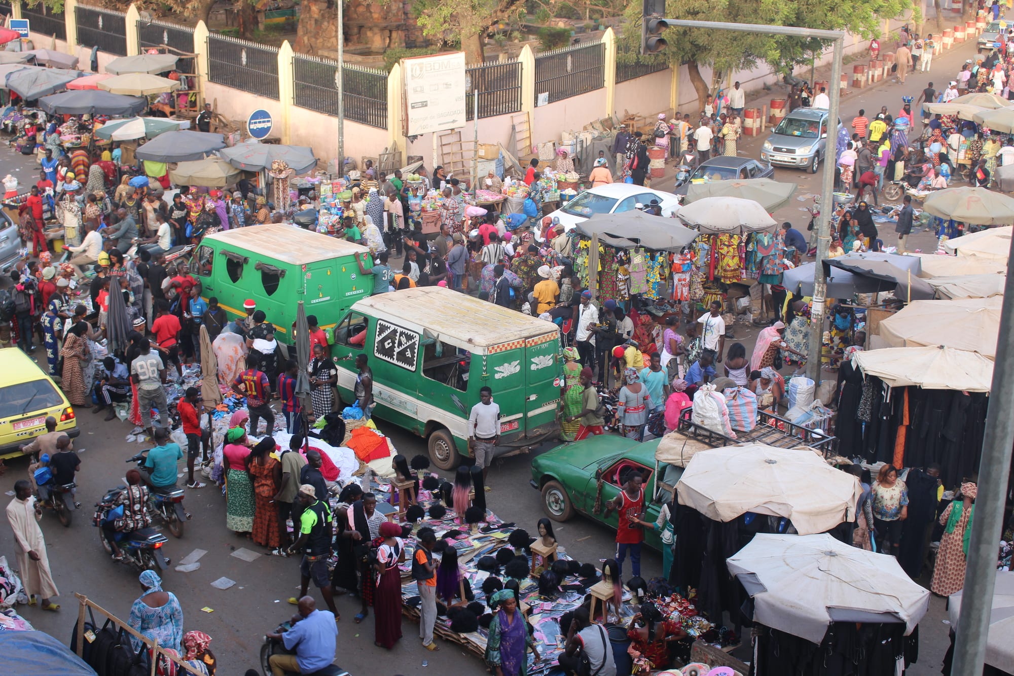
A crowded market street seen from above, with parasols, cloth stalls, green minibuses and shoppers filling the road

Bamako & the South, Mali

Bamako

The streets around the Grand Marché in central Bamako, with the green sotrama minibuses that serve the city. (Carolinerre / Wikimedia Commons · CC BY-SA 4.0)

Mali's capital, on both banks of the Niger, a small trading town when the French arrived in 1883 and a capital district of 4,227,569 people at the 2022 census, more than forty times its population at independence. It holds the National Museum of Mali and a music scene of international standing. This page is written to explain the city, not to encourage travel.

Neighbourhoods

  • The centre and the Grand Marché
    • First-time visitors
    • Markets
    • Historic district

    The old core on the north bank, in Commune III, where the Grand Marché, the Grand Mosque, the cathedral and the ministries stand within a few blocks. Streets are narrow, crowded and loud with traffic, and the pink-painted market building gives the quarter its other name, the Marché Rose.

    Open in Maps
  • Hippodrome
    • Best for food
    • Nightlife
    • Embassies and hotels

    A north-bank quarter of embassies, hotels, restaurants and bars, long the base for foreign residents and the city's late-night district. A restaurant here was attacked by gunmen in March 2015, and security at such places has been heavy since.

    Open in Maps
  • ACI 2000
    • Business
    • Modern buildings

    A planned business district immediately west of the centre, laid out on the geometric grid left by the old airport runways, with wide avenues, bank headquarters, offices, hotels and shopping centres. It is where most of Bamako's newer tall buildings stand, and it feels a world away from the old market streets.

    Open in Maps
  • Badalabougou and the south bank
    • Quiet and residential
    • Riverside

    Across the Martyrs and King Fahd bridges, the southern communes have grown from villages into most of the city's living space, with university faculties, compounds, riverside grills and long, dusty commercial avenues running south towards the airport.

    Open in Maps
  • Koulouba and Point G
    • Views
    • Quiet and residential

    The escarpment above the north bank holds the presidential palace at Koulouba, built for the French governor between 1903 and 1907, and the Point G plateau with its hilltop hospital, built between 1906 and 1913. The road up gives the widest view over the city and the river.

    Open in Maps

Things to do

Landmarks and museums

  • National Museum of Malimuseum

    Mali's chief museum, with masks, textiles, musical instruments and archaeological finds, and concrete models of the Djenné and Timbuktu mosques on its grounds.

    Open in Maps
  • Grand Mosque of Bamakolandmark

    Built with Saudi funding at the end of the 1970s on the site of a pre-colonial mud-brick mosque, its tall cement minarets visible from much of the city.

    Open in Maps
  • Bamako Cathedrallandmark

    The Sacred Heart cathedral, begun in 1925 and completed in 1936, seat of the Archdiocese of Bamako and a reminder of the city's small Christian community.

    Open in Maps
  • BCEAO Towerlandmark

    The Malian headquarters of the Central Bank of West African States on the north bank, a twenty-storey tower in Sahelian style and the tallest building in the country.

    Open in Maps
  • Koulouba Palacelandmark

    The president's residence on the hill above the city, built between 1903 and 1907 for the governor of French Sudan; it is seen from the road rather than visited.

    Open in Maps
  • Martyrs Bridgelandmark

    The city's first bridge over the Niger, opened in 1957 and renamed in 1991 for the protesters killed in the uprising against Moussa Traoré.

    Open in Maps
  • King Fahd Bridgelandmark

    The second road bridge across the Niger at Bamako, opened in 1992 with Saudi funding and known locally as the new bridge.

    Open in Maps

Sport and transport

  • Stade du 26 Marsattraction

    Mali's national stadium, on the southern edge of the city, used for international football and for large public occasions.

    Open in Maps
  • Stade Modibo Kéïtaattraction

    The older city-centre stadium, holding 35,000 and used mostly for football as the home ground of AS Real Bamako and occasionally of the national team.

    Open in Maps
  • Modibo Keita International Airporttransit hub

    Mali's main airport, about 15 kilometres south of the centre at Sénou, and the country's only reliable link to the outside world.

    Open in Maps

Short trips from the city

  • Katiattraction

    A garrison town about 15 kilometres north-west, whose army camp was the starting point of the coups of 2012 and 2020.

    Open in Maps
  • Koulikoroattraction

    A river town about 60 kilometres downstream, the end of the railway from Dakar and the place where Bamako's river port traffic is handled.

    Open in Maps
  • Sibyattraction

    A village below red sandstone cliffs south-west of the capital, known for the natural rock arch of Kamandjan above it.

    Open in Maps
  • Kangabaattraction

    A Mandé town upriver whose sacred Kamablon house is re-roofed every seven years in a ceremony recognised as UNESCO intangible heritage.

    Open in Maps

Seasonal events

  • Bamako Encountersautumn and winter, every two years

    Africa's largest photography biennial, held in the city since 1994, with exhibitions spread across the National Museum and other cultural centres.

  • Eid al-Fitrvaries with the lunar calendar

    The feast that ends Ramadan, marked by mass prayers on open ground, new clothes and family visiting across the city.

  • Tabaskivaries with the lunar calendar

    The sheep festival, the biggest family occasion of the Malian year, when rams are bought at roadside markets for weeks beforehand.

Eat and drink

Long-standing places and food districts in Bamako. Hours, ratings and directions come from your maps app, always current.

Markets and food districts

  • Grand Marché and the surrounding streetsmarket

    The central market and the lanes around it, where cloth, spices, dried fish, fruit and cooked food are sold from stalls, barrows and shopfronts.

    Open in Maps
  • Hippodromeneighborhood

    The quarter with the widest choice of restaurants and bars in the city, serving Malian, Lebanese, Senegalese and French cooking.

    Open in Maps
  • Riverside grills at Badalabougouneighborhood

    Open-air places on the south bank where capitaine and tilapia from the Niger are grilled whole over charcoal and eaten with attiéké or chips.

    Open in Maps

Experience Bamako

History

Bamako was a small settlement on the north bank of the Niger, founded by the Niaré family and living on trade at the rapids that divide the upper and middle river, when the French officer Gustave Borgnis-Desbordes arrived in 1883. Its position mattered more than its size: the Niger was navigable downstream from here towards Ségou, Mopti and Timbuktu, and the railway being pushed inland from the Senegal coast was aimed at the same point. The French built a fort, then a town of low administrative buildings in a Sudanese style along the river.

The railway from Kayes reached Bamako in 1904 and continued to Koulikoro, and in 1908 the city was named capital of French Sudan; the through line from Dakar was completed in 1923. Independence in 1960 made it the capital of Mali, with about 100,000 people. Growth after that was extraordinary. Drought in the Sahel in the 1970s and 1980s drove farmers and herders into the city, the south bank filled with new quarters once the Martyrs Bridge opened in 1957 and the King Fahd Bridge in 1992, and the population passed four million by the 2022 census.

The capital has also been the stage for the country's politics. Protests in March 1991 ended the rule of Moussa Traoré and gave the Martyrs Bridge its name; the coups of 2012 and 2020 were launched from the army camp at Kati, just outside the city. Since the insurgency in the Sahel spread south, Bamako has been attacked directly, including a hotel siege in 2015 in which twenty-one people were killed and coordinated attacks on a gendarmerie school and the airport in September 2024.

Culture & Customs

Bamako is one of the great music cities of Africa. The griot, or jeli, families who keep the genealogies and the Sundiata epic with kora, ngoni and balafon live and record here; so do the singers and bands who carried Malian music abroad, among them Salif Keïta, Oumou Sangaré, Toumani Diabaté and the duo Amadou & Mariam. Weddings and baptisms are where most of that music is actually heard, with amplified bands playing into the night in courtyards and on closed-off streets, and the city's studios and clubs have long supplied the rest.

The city is also the country's visual and intellectual centre. The National Museum of Mali holds the most important collection of masks, textiles and archaeology in the country, and since 1994 the Bamako Encounters biennial has made the capital the meeting point of African photography. Bogolan mud-cloth, leatherwork, silver and woodcarving are made and sold in the artisans' quarter near the centre.

Bambara, or Bamanankan, is the language of the street, of markets and of radio, spoken alongside French in offices and the many other languages migrants bring with them. Islam is the majority faith and its rhythms order the week, though the city is used to a Christian minority and to older Bambara traditions. Family names carry clan histories, and the joking relationships between them — a Traoré teasing a Coulibaly — smooth daily dealings.

Daily Life

Some 4,227,569 people were counted in the Bamako capital district at the 2022 census, more than forty times the figure at independence, and the city keeps drawing people from the countryside and, increasingly, from the conflict zones of the centre and north. Building spreads up the hills and out across the plain faster than roads, drainage or water supply can follow. The district's communes are divided by the river, with the older administration and commerce on the north bank and most of the housing growth on the south.

Work is largely informal: market trading, transport, workshops, building sites and domestic service, alongside the ministries, banks, telecoms firms and aid agencies that make up the formal economy. Gold, cotton and remittances from Malians abroad underpin much of it. Days start early with the first prayer and the green sotramas heading for the bridges, slow through the afternoon heat, and end with tea, football and conversation on the street.

The strains are obvious. Power cuts have run for hours at a time, fuel shortages caused by blockades on the supply roads have brought long queues at petrol stations, prices have risen, and displaced families from the centre of the country have arrived in large numbers. Schools, hospitals and transport are all stretched by a population that has grown far faster than the services meant to serve it.

Food

The Bamako table is built on grain and sauce. A stiff porridge of millet, maize or sorghum is eaten with sauces of baobab leaf, okra or groundnut; rice comes as riz au gras, cooked in oil and tomato with meat, or with tiga dege na, the peanut stew known more widely as maafé. Fonio, a fine local grain, is served steamed. Soumbala, the pungent fermented seasoning made from néré seeds, and shea butter give the sauces their depth.

Fish from the Niger is central: capitaine, the Nile perch, grilled whole over charcoal at riverside places, and smoked or dried fish brought down from the inland delta for the sauce pot. Street food means brochettes of mutton, fried plantain and yam, bean fritters and sandwiches of bread with spaghetti or meat. Breakfast is often moni, a millet porridge taken with sugar and milk, or bread and sweet coffee from a stall; dégué, sweetened millet couscous with milk, is the standard dessert.

Drinks are ginger juice, hibiscus juice, tamarind and baobab-fruit drinks, and above all green tea, boiled with sugar and poured from a height into small glasses in three rounds that take an hour or more. Lebanese restaurants have long been part of the city's eating out, and the Grand Marché and the neighbourhood markets supply nearly everything cooked at home.

Planning tools

Budget

There is no tourist market to set prices. Costs in Bamako are driven by hotels aimed at aid agencies, diplomats and business travellers, by hiring a car with a driver, and by the fees of local contacts who arrange movement. Street food, markets and shared transport are cheap; almost everything arranged for a foreigner is not. Fuel shortages and blockades have pushed transport costs up sharply at times.

Daily Budget Midrange
USD 170–350 (Bamako hotel, driver and a local fixer)
Daily Budget Shoestring
USD 60–110 (a simple guesthouse, street food, sotrama minibuses and shared taxis)

Carry enough cash in CFA francs for the whole stay, and arrange transport through trusted local contacts rather than on the street.

Best Time to Visit

November to February is the cooler dry season, when nights drop and the Harmattan haze is the main nuisance. March to May is punishing, often above 40°C, and the rains from June to October bring storms, flooding in the low-lying quarters and green on the hills. In practice the security situation, not the weather, decides what is possible.

Suggested Number of Days

Two or three days cover the museum, the markets and the river in the limited way current conditions allow. Four or five would take in the towns along the Niger west and north of the capital, if security arrangements permit any movement outside the city at all.

First Visit
2–3 days
With Surroundings
4–5 days

Transportation

Green minibuses called sotrama, shared taxis and motorbikes carry most people, with the three road bridges over the Niger funnelling the traffic and jamming at either end in the mornings and evenings. There is no rail or metro network within the city. Foreign visitors almost always use a hired car with a driver.

Avoid moving around after dark, expect police and army checkpoints, and do not use intercity roads without current local security advice.

Airport & Station Connections

Modibo Keita International Airport at Sénou, about 15 kilometres south of the centre, is Mali's main gateway, with a limited number of airlines flying from other African capitals and a few cities beyond; the drive into town takes around half an hour in normal traffic. Paved roads run south to Sikasso and west to Kayes and Senegal, and a train service to Kayes restarted in 2023, but overland routes cross insecure territory.

Walkability

The centre around the Grand Marché is walkable in the sense that it is compact and always busy, but pavements are broken or occupied by traders, traffic is heavy, and the heat and dust are hard going for most of the year. Beyond that core the city is very spread out and built for vehicles, and foreigners on foot draw attention.

Safety

Most governments advise against all travel to Mali, including the capital. Bamako has been the target of jihadist attacks during the insurgency in the Sahel: gunmen killed twenty-one people in a hotel siege in 2015, and on 17 September 2024 fighters of the al-Qaeda-linked JNIM attacked a military training school and set aircraft alight at the international airport, the first jihadist attack on the city since 2016. JNIM also imposed a blockade on fuel imports from the neighbouring countries in September 2025, crippling the state's functioning in the south until a prisoner-exchange truce lifted it, and from 25 April 2026 JNIM and the Azawad Liberation Front launched the largest coordinated offensive since 2012, with attacks in Bamako, Kati and other towns. Kidnapping of foreigners is a real risk, and street robbery is common.

Globeway covers Mali so its history and culture can be understood — the empires, the manuscripts, the music, the mud architecture — not to suggest that a visit is currently possible or wise. Keep a low profile, vary routines, avoid places where foreigners gather, and register with an embassy if one is present. Check current official travel advice before travelling.

Climate

A tropical savanna climate with one rainy season. The year runs from a dry, dusty Harmattan season to fierce pre-monsoon heat and then to storms, and the Niger rises and falls with the rains upstream.

Summer
rainy season June–October, humid and stormy, around 24–34°C, with the heaviest falls in July and August
Winter
dry and hazy from November to February, around 17–33°C, with cool nights; very hot from March to May, often above 40°C

Local Customs

Greetings are long and matter: a string of questions about family and health comes before business, and the right hand is used for eating and giving. Islam shapes the week, with Friday prayers emptying offices at midday, and modest dress is expected of men and women alike. Tea is poured in three rounds and refusing the first glass is awkward. The joking-cousin banter between family names is a normal part of courtesy.

Ask before photographing people, and never photograph soldiers, police, checkpoints, bridges or government buildings. Alcohol is sold in hotels and some restaurants but drinking is discreet; tipping is not obligatory but small amounts are welcomed.

Common Payment Methods

The currency is the West African CFA franc, pegged to the euro. Bamako is a cash economy: cards work only at a few hotels and large supermarkets, ATMs are unreliable and may run out of notes, and euros are the easiest cash to change. Mobile money is widely used by residents for transfers and bills.