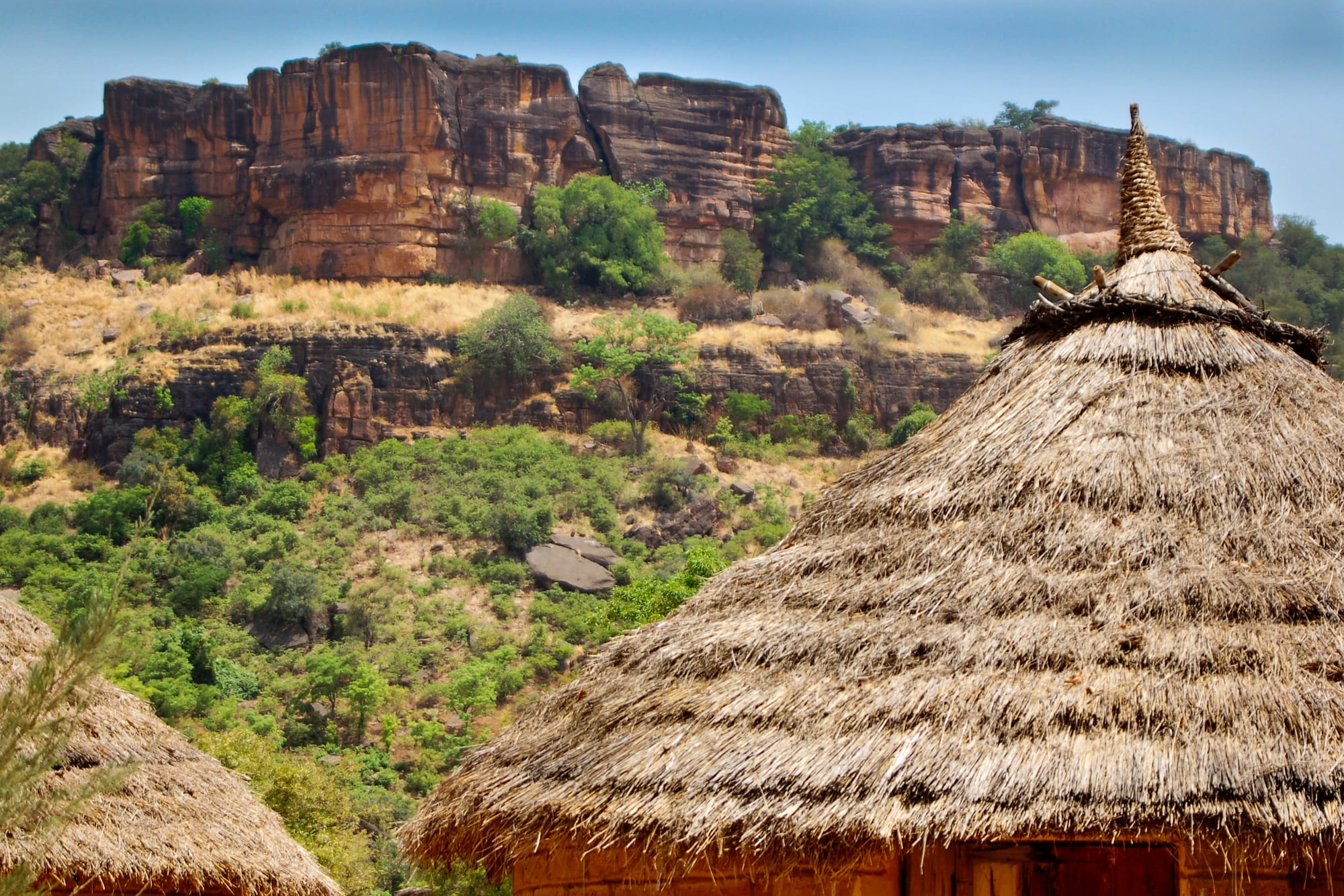
Red sandstone cliffs above a wooded green slope, with the thatched conical roof of a round hut in the foreground

Mali

Bamako & the South

Sandstone cliffs of the Mandé plateau near Siby, south-west of Bamako. (Ralf Steinberger / Wikimedia Commons · CC BY 2.0)

Mali's greener, wetter south — the capital Bamako on the Niger, the Mandé heartland where the medieval Mali Empire began, the cotton and mango country of Sikasso and the Senegal River basin around Kayes — home to most Malians and, though not spared by the insurgency, the part of the country where ordinary life continues most fully.

Explore Bamako & the South

History

The south is the Mandé heartland. Here, according to the epic told by griots, Sundiata Keita defeated the Sosso king Soumaoro Kanté at Kirina in the 13th century and founded the Mali Empire; the assembly at Kouroukan Fouga, near Kangaba, is remembered as the place where the new state's rules were proclaimed. Gold from the fields of the upper Niger and Senegal made the empire rich, and the Malinké and Bambara peoples who descend from it still dominate the region.

After the empire's decline the south broke into smaller states. The Bambara kingdom of Ségou held the Niger valley, and in the 19th century the Senufo kingdom of Kénédougou, ruled from Sikasso by Tieba Traoré and then Babemba Traoré, built massive earthen walls that withstood a long siege by the conqueror Samori Touré in the late 1880s. The French advanced from the Senegal River: they built a fort at Médine near Kayes, which held out against El Hadj Umar Tall's forces in 1857, reached Bamako — then a modest trading town — in 1883, and took Sikasso in 1898, when Babemba chose death over surrender.

Kayes was the capital of French Sudan from 1892, but the Dakar–Niger railway, completed in the early 20th century, shifted weight to Bamako, which became the capital of French Sudan in 1908 and of independent Mali in 1960. The capital has been the stage of every political turn since: the March 1991 protests that ended Moussa Traoré's rule, and the coups of 2012 and 2020, both launched from the army camp at Kati just outside the city.

Culture & Customs

Bambara, or Bamanankan, is the language of the south's streets, markets and radio, and its Malinké cousin is spoken in the Mandé hills; the Senufo and Minianka live around Sikasso and Koutiala, the Soninke and Khassonké around Kayes, and Fula herders throughout. Islam is the majority faith, but older traditions run deep: the Bambara initiation societies such as the Komo, the carved antelope headdresses called ciwara danced in honour of farming, and the brotherhoods of donso hunters with their own songs and costumes. In Kangaba the Kamablon, a sacred house, is re-roofed every seven years in a ceremony recognised as UNESCO intangible heritage, and the balafon traditions of the Senufo are listed too.

Music is the region's calling card. The griots, or jeli, keep genealogies and the Sundiata epic alive with kora, ngoni and balafon; the Wassoulou country south of the Niger gave its name to a style of women's song made famous by Oumou Sangaré; and the region produced Salif Keïta, Toumani Diabaté and the duo Amadou & Mariam.

The Soninke of the Kayes region have a long tradition of emigration, not least to France, and their home villages are built on money sent back. Greetings are long and matter everywhere, family names signal clan alliances, and the joking-cousin banter between clans is part of daily courtesy.

Daily Life

Bamako, spread along both banks of the Niger beneath the Koulouba and Point G hills, has grown from a colonial town to a city of more than four million people, and is still growing fast. Sikasso, Kayes, Koutiala, Kita, Bougouni and Koulikoro are the other main towns.

The south is Mali's farm belt. Cotton, grown by small family farms, is the main cash crop, alongside maize, millet, sorghum, mangoes, potatoes and shea nuts. Gold mines in the Kayes region and around Sikasso are the country's biggest export earners, and lithium is now mined near Bougouni. The Sélingué dam on the Sankarani and the Manantali dam on the Bafing supply much of the country's electricity.

In Bamako the day starts with the call to prayer, a breakfast of porridge or bread, and green sotrama minibuses crossing the bridges into the centre. Markets fill before the heat, work slows in the afternoon, and evenings are for tea on the street, football and wedding parties. Fuel shortages, power cuts, rising prices and the flow of displaced people from the centre weigh on the city.

Food

Southern cooking is built on grain and sauce. Tô, the stiff millet or maize porridge, is eaten with sauces of baobab leaf, okra or groundnut; tiga dege na, a Bambara peanut stew with meat, is often equated with the maafé known across the region. Breakfast is often moni, balls of millet flour boiled with sugar and milk, or bread with coffee, and dégué, a sweet mix of millet and sour milk, is a favourite dessert.

The south's orchards and fields shape the table: mangoes, cereals and vegetables from the Sikasso region, and shea butter, karité, used for cooking as well as the skin. Soumbala, the fermented néré-seed seasoning, gives sauces their depth. Fish comes fresh or smoked from the Niger at Bamako and Koulikoro.

On the street in Bamako the staples are grilled mutton and brochettes, fried plantain and yam, and bean fritters. Drinks are ginger, hibiscus and tamarind juices and the rounds of sweet green tea; in non-Muslim villages of the south, home-brewed millet beer is still made for festivals and farm work.

Attractions & Natural Wonders

Bamako itself holds the region's best museum, the National Museum of Mali, with its masks, bogolan cloth and archaeological finds, set beside a botanical garden and a zoo. The Grand Marché and the artisans' market sell cloth, jewellery and leather, the Koulouba and Point G hills give views over the river, and the city hosts the Rencontres de Bamako, a biennial of African photography.

South-west of the capital, the Mandé hills rise in sandstone escarpments around Siby, where the natural rock arch of Kamandjan crowns a ridge. Further up the Niger, Kangaba guards the Kamablon sacred house, heart of the Mandé tradition.

Sikasso keeps fragments of its great earthen walls, the tata, and the Mamelon hill in the town centre; nearby are the Farako falls and the caves of Missirikoro.

West along the Dakar–Niger railway lies the Kayes railway country: Kita beneath Mount Kita, the Boucle du Baoulé national park, and Kayes on the Senegal River, with the old French fort of Médine and the Félou falls just upstream. At Bafoulabé the Bafing and the Bakoye meet to form the Senegal River, and between there and Kayes the river drops over the Gouina falls, a wide curtain of water at its best after the rains.

Cities in Bamako & the South

Planning basics

Budget

The south is where the few visitors to Mali spend almost all their time, and Bamako has the country's only real range of hotels, priced for aid workers, business travellers and diplomats. Outside the capital, guesthouses in Sikasso and Kayes are basic and cheap, but any trip needs a trusted driver and local contacts, which is where the cost lies. Cash in CFA francs is essential; cash machines are few outside Bamako.

Daily Budget Midrange
USD 170–350 (Bamako hotel, driver and a local fixer)
Daily Budget Shoestring
Not realistically applicable given the security situation

Arrange transport and any movement outside Bamako through trusted local contacts, and carry enough cash for the whole trip.

Safety

The south is safer than the centre and north, but not safe. Most governments advise against all travel to Mali, including Bamako. JNIM, the al-Qaeda-linked insurgent coalition, has struck inside the capital, including an attack on a gendarmerie school and the airport area in 2024, and has attacked towns and fuel convoys in the Kayes and Sikasso regions, causing severe fuel shortages. Kidnapping of foreigners is a real risk, and criminal robbery on the roads is common.

Globeway covers Mali so its history and culture can be understood — the empires, the manuscripts, the music, the mud architecture — not to suggest that a visit is currently possible or wise. Stay in Bamako unless there is a pressing reason, keep a low profile, vary routines, and register with an embassy if one is present. Check current official travel advice before travelling.

Climate

The wettest and greenest part of Mali. Bamako and Kayes have one rainy season from about June to October, while the Sikasso region in the far south gets over a metre of rain a year and has wooded savanna rather than Sahel scrub. Kayes, in the Senegal River valley, is notorious as one of the hottest towns in Africa in April and May.

Summer
rainy season June–October, humid and stormy, around 25–33°C
Winter
dry and dusty Harmattan season, warm days and cooler nights around 17–33°C; very hot from March to May

Transportation

Modibo Keita International Airport, at Sénou south of the capital, is Mali's main gateway. Paved roads run from Bamako to Sikasso and on to Côte d'Ivoire and Burkina Faso, and west to Kayes and Senegal, but convoys on these routes have been attacked and checkpoints are frequent. The Dakar–Niger railway through Kita and Kayes, once the region's lifeline, lost its international passenger trains in 2010; a Kayes–Bamako service restarted in 2023. Within Bamako, green minibuses called sotrama, taxis and motorbikes do the work.

Do not drive between towns at night, and follow local security advice before using any intercity road.

Best Time to Visit

November to February is the cooler dry season, when the roads are passable and the Harmattan haze is the main nuisance. The rains turn the south green but cut dirt roads and make travel slow. In practice the security situation, not the weather, decides whether any movement outside Bamako is possible.