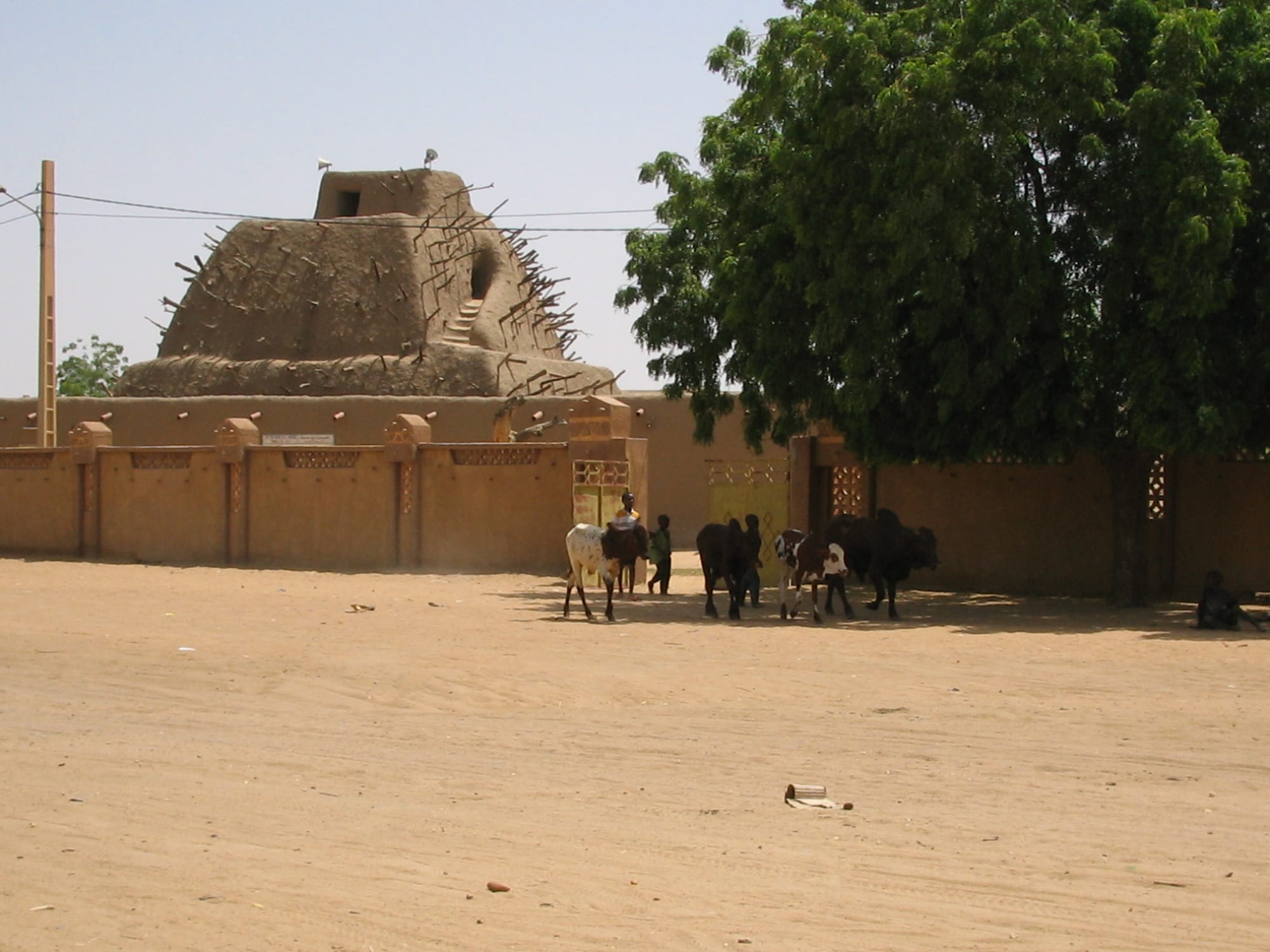
A stepped mud-brick pyramid bristling with wooden beams behind an ochre wall, with cattle crossing a sandy square

Mali

Timbuktu & the Sahara

The Tomb of Askia in Gao, built for the Songhai ruler Askia Mohammad at the end of the 15th century. (David Sessoms / Wikimedia Commons · CC BY-SA 2.0)

Northern Mali, more than half the country's land but a small share of its people — the Niger Bend with Timbuktu and Gao, the desert plains of Taoudénit, the Adrar des Ifoghas around Kidal and Ménaka in the east — once the heart of the Songhai Empire and the trans-Saharan trade, and since 2012 the scene of rebellion and jihadist war.

Explore Timbuktu & the Sahara

History

The Niger Bend, where the river swings closest to the Sahara, was where the desert and the savanna met to trade. Gao was an important regional power by the 9th century, and Timbuktu grew from a seasonal Tuareg camp founded around 1100 into the port where camel caravans met river boats. Under the Mali Empire, Mansa Musa passed through on his return from Mecca in 1325 and is credited with commissioning the Djinguereber mosque. Under Songhai, whose rulers Sonni Ali and Askia Mohammad built one of the largest empires in African history from Gao in the late 15th century, Timbuktu became a city of scholars, with thousands of students at its mosques and a trade in books.

In 1591 a Moroccan army crossed the Sahara with firearms, defeated Songhai at Tondibi near Gao and sent Timbuktu's leading scholar, Ahmed Baba, into exile. The Arma, descendants of the Moroccan soldiers, ruled the towns for generations while Tuareg confederations dominated the desert. European explorers struggled to reach the city: Alexander Gordon Laing got there in 1826 and was killed on the way out; René Caillié came back in 1828. The French occupied Timbuktu in the 1890s.

Since independence the north has seen repeated Tuareg rebellions, in 1962–64, 1990–95 and 2007–09, driven by claims of neglect and repression. In 2012 the separatist MNLA declared a state called Azawad, but jihadist groups soon took over the north's cities, destroying Sufi shrines in Timbuktu, until a French-led intervention in 2013. A 2015 peace deal signed in Algiers never fully worked; the junta ended it in 2024, and fighting between the army, separatists and jihadists continues.

Culture & Customs

The north is home to Songhai farmers and fishermen along the river, Tuareg pastoralists across the desert, Arab and Moorish traders in Timbuktu and the salt country, and Fula and Bozo communities. Songhai is the language of Gao and Timbuktu's streets, Tamasheq of the Tuareg, and Arabic of the Moorish traders.

Timbuktu's identity is built on learning and on Sufi Islam: it is called the City of 333 Saints, whose mausoleums were destroyed in 2012 and restored from 2015, and the destruction led to the first International Criminal Court conviction for attacks on cultural heritage. Families still guard private libraries of manuscripts, many of which were smuggled south to Bamako in 2012.

Tuareg society is known for its indigo veils, the tagelmust worn by men, silver jewellery and leatherwork, a script called tifinagh, and poetry and music. The tende drum and the imzad fiddle accompany gatherings, and from the 1980s Tuareg guitar music — Tinariwen formed among Tuareg exiles in Algeria and Libya — carried the region's songs to the world. Tea is served in three small glasses, and hospitality to the traveller is a matter of honour.

Daily Life

The region is large and thinly peopled. Gao and Timbuktu are the main cities, each with tens of thousands of people; Kidal, Ménaka, Bourem, Goundam and Ansongo are small towns, and much of the population lives in villages along the river or moves with herds of camels, goats and cattle. Taoudénit, a region created in 2012 and set up in 2016, has very few permanent inhabitants.

Along the Niger, people grow rice and millet in the floodplain, fish and trade by boat; in the desert, herding and caravan trade in salt, dates and livestock have long been the livelihood. Trade with Algeria and Niger, legal and illegal, supplies much of the region's fuel and food, and smuggling of goods, migrants and drugs has shaped the economy and fed armed groups.

Daily life is dominated by the war. Blockades have cut roads and river traffic, sending prices soaring; schools have closed across large areas; aid is hard to deliver; and many people have fled to neighbouring countries or to camps further south. Past droughts, which killed herds and emptied camps, are remembered as a turning point, and water and pasture remain the constant worries.

Food

The north's cooking divides between river and desert. Along the Niger, rice is the staple, grown in the floodplain and served with fish or with fakoye, a northern sauce of dried, pounded jute leaves. Timbuktu is known for dishes of rice or couscous with mutton.

In the desert, the Tuareg staple is taguella, a flatbread of millet or wheat baked in the hot sand beneath the embers of a fire and broken into a sauce of meat or tomato. Milk from camels and goats is drunk fresh or soured, dried cheese is carried on journeys, and meat — goat, mutton and on feast days camel — is grilled or stewed. Dates from the oases and the Algerian trade are staples.

Tea is the central ritual: gunpowder green tea boiled with lots of sugar, sometimes with mint, poured from a height to raise a froth and served in three rounds. Salt from Taoudénit, carried south by caravan for centuries, still seasons food across the region.

Attractions & Natural Wonders

Timbuktu is the region's great name. Its three mud mosques — Djinguereber, built in the 14th century, Sankore, once the heart of a university of scholars, and Sidi Yahia — and its mausoleums of saints form a UNESCO World Heritage Site, currently on the danger list. The Ahmed Baba Institute and family libraries hold the Timbuktu manuscripts, texts on law, theology, astronomy, medicine and poetry, and the houses where Laing, Caillié and Heinrich Barth stayed are marked in the old town. The Festival au Désert was held in the dunes at Essakane from 2003 to 2009 and on the edge of the city until 2012.

Downstream, Gao has the Tomb of Askia, a stepped mud pyramid built for Askia Mohammad at the end of the 15th century and a UNESCO World Heritage Site, with two mosques, a cemetery and an assembly ground.

North-east, the Adrar des Ifoghas rises around Kidal in granite hills and dry valleys, with prehistoric rock engravings and the ruins of Essouk, the medieval trading town of Tadmekka. Far to the north, the salt caravans of Taoudénit — the azalai — carry slabs of rock salt cut from the mines by hand on the long desert crossing towards Timbuktu. East of Gao, the Ménaka region borders Niger.

Cities in Timbuktu & the Sahara

Planning basics

Budget

There is no tourism in the north. The few outsiders are aid workers, journalists and officials travelling with security arrangements, often by air, and ordinary costs are inflated by blockades, fuel shortages and the difficulty of moving goods. Nothing can be planned on a traveller's budget.

Daily Budget Midrange
Not realistically applicable; costs depend entirely on security arrangements
Daily Budget Shoestring
Not realistically applicable given the security situation

Do not plan travel to northern Mali; there are no functioning services for visitors.

Safety

Northern Mali is an active war zone, and most governments advise against all travel. The army and its Russian allies are fighting both the al-Qaeda-linked JNIM and the Islamic State Sahel Province, which is most active around Ménaka and on the Niger border, while Tuareg-led separatist groups resumed fighting in 2023. Towns have been besieged and blockaded, river boats attacked, and civilians killed by all sides. The risk of kidnapping of foreigners is extreme.

Globeway covers Mali so its history and culture can be understood — the empires, the manuscripts, the music, the mud architecture — not to suggest that a visit is currently possible or wise. Do not travel to northern Mali. Check current official travel advice before travelling.

Climate

The hottest and driest part of Mali. Timbuktu and Gao sit on the southern edge of the Sahara, with a short, unreliable rainy season in July and August and heat that regularly passes 40°C from April to June. Further north, around Taoudénit and in the Adrar des Ifoghas, rain is rare, days are scorching and winter nights can be cold. Sandstorms and dust are common.

Summer
extremely hot, often 40–45°C, with brief storms on the Niger Bend in July and August
Winter
warm, dry days around 28–32°C and cold desert nights, sometimes near freezing in the far north

Transportation

Distances are vast and roads few. Timbuktu and Gao have airports, and the Niger was the traditional link between them and Mopti by boat. The desert tracks north to Kidal, Taoudénit and the Algerian border are used by trucks, smugglers and armed groups, and the roads in the region have been blockaded, mined and ambushed repeatedly.

Do not travel overland in northern Mali; road and river routes have been attacked and blockaded.

Best Time to Visit

In principle November to February, the cooler season in which the Festival au Désert was once held near Timbuktu. At present the conflict rules out any travel to the region.