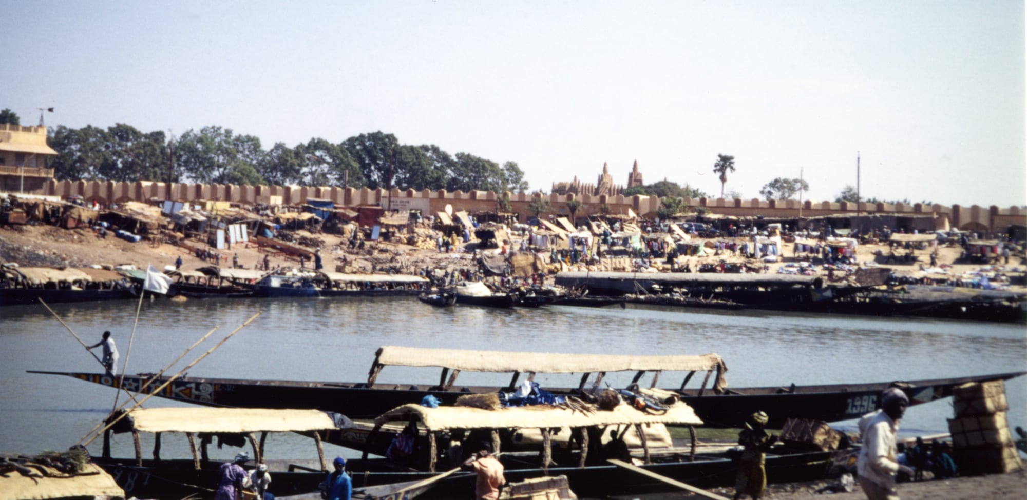
Long wooden river boats with canopies moored on a calm river, with a busy waterfront, a mud-walled town and a mosque's towers beyond

Mali

Ségou, Mopti & the Niger Bend

Pinasses, the long wooden river boats of the Niger, in the port of Mopti, with the town's mosque in the background. (Jeanne Menjoulet / Wikimedia Commons · CC BY 2.0)

Central Mali, where the Niger spreads into its vast inland delta before bending north towards the desert — the land of the Djenné mosque, the river port of Mopti, the Dogon villages of the Bandiagara escarpment and the old Bambara capital of Ségou, and since 2015 the main battleground of Mali's insurgency.

Explore Ségou, Mopti & the Niger Bend

History

The inland Niger delta is one of the oldest urban landscapes in West Africa. Djenné-Djeno, a mound just outside modern Djenné, was a town from around the 3rd century BC, trading over long distances long before Islam arrived. Djenné itself rose as its successor and, with Timbuktu, became a twin city of trade and scholarship: gold came up from the south to its markets and was shipped downriver to the desert. The Songhai ruler Sonni Ali took it in the 15th century, and Moroccan forces followed after 1591.

In the 18th century the Bambara kingdom of Ségou, built into an empire by Biton Coulibaly, dominated the upper river. In 1818 the Fula cleric Seku Amadu launched a jihad that created the Massina state, a strict Islamic theocracy governed from his new capital Hamdallaye near Mopti. Both fell in the early 1860s to El Hadj Umar Tall, the Tukulor conqueror, who disappeared in the Bandiagara cliffs in 1864; his heirs ruled from Ségou and Bandiagara until the French conquest.

Colonial rule brought the Office du Niger, an irrigation scheme built with forced labour in the colonial period around the Markala dam, which turned the plains north of Ségou into Mali's rice bowl. Mopti grew from a village into a busy river port. After independence the region became the hub of Mali's tourism, until the 2012 crisis and the insurgency that spread into the centre from 2015 emptied the Dogon country and the delta of visitors.

Culture & Customs

The centre is a meeting point of peoples. Bambara farmers hold the Ségou plains, Bozo and Somono fishermen work the rivers, Fula herders move their cattle through the delta, and the Dogon farm the Bandiagara plateau and the plain below it. The relationships between them — herders and farmers, fishermen and traders — were long governed by agreements on grazing and water, and the breakdown of those arrangements lies behind much of today's violence. Each year the Fula herds returning from transhumance swim across the Niger at Diafarabé in the Yaaral cattle crossing.

The Dogon are renowned for their cosmology, their masks and their architecture. Mask societies perform the dama dances to guide the dead, the Sigui ceremony is held roughly every sixty years, and each village has a hogon, a spiritual leader, and a togu na, a shelter for the men whose very low roof forces those inside to sit rather than stand. Many Dogon are now Muslim or Christian, while keeping older rites.

Djenné's masons, organised in a guild, direct the town's annual re-plastering of the Great Mosque, and Ségou is known for pottery at Kalabougou, bogolan cloth and the Festival sur le Niger, a music festival launched in 2005.

Daily Life

Ségou and Mopti are the main towns, each with somewhere around 100,000 to 150,000 people; Sévaré, the crossroads beside Mopti, San, Niono, Djenné and Bandiagara follow. The countryside is farming, herding and fishing: irrigated rice in the Office du Niger zone, millet and onions in the Dogon country, cattle in the delta, and dried and smoked fish sent to markets across West Africa.

Life follows the river. When the flood spreads in autumn the delta turns into a waterscape of islands, boats and rice fields; when it retreats the herds move in to graze the bourgou grass. Market days move from town to town through the week, and Djenné's Monday market still fills the square in front of the mosque.

The conflict dominates daily life. Across much of Mopti and parts of Ségou, armed groups impose their rules on dress, schooling and taxes, villages have been besieged or burned, schools have closed and hundreds of thousands of people have fled to the towns. Tourism, which once employed guides, drivers and campement owners, has vanished.

Food

The centre eats from the river and the rice fields. Rice from the Office du Niger and the delta is the staple, and fish — capitaine, the Nile perch, and catfish and tilapia — is grilled, fried or cooked in a tomato sauce; smoked and dried fish from Mopti is the region's most famous export. Fula households live on milk, drunk fresh or soured, with millet porridge and butter.

The Dogon grow onions alongside their grain, and sell them across the region. Millet is the Dogon staple, eaten as tô with a sauce of baobab leaves or onions, and millet beer is brewed for work parties and ceremonies in non-Muslim villages.

Ségou shares the Bambara kitchen of the south: tô, groundnut stews and fonio, with shea butter and soumbala in the sauces. Across the region, tea is poured in three rounds, and street food is grilled mutton and fried fish.

Attractions & Natural Wonders

Djenné, on an island in the Bani floodplain, is the region's great monument. Its Great Mosque, rebuilt in 1907, rises from a platform above the market square, with palm-wood beams jutting from its walls as scaffolding for the yearly re-plastering; the town's mud-brick houses and the site of Djenné-Djeno are listed together as a UNESCO World Heritage Site.

Mopti, where the Bani joins the Niger, is built on dykes and islands, and its river port is crowded with painted pinasses, boats and baskets of dried fish; the Komoguel mosque rises in the old quarter. Around it the inland delta spreads over thousands of square kilometres of floodplain, with Lake Débo and huge colonies of waterbirds.

East of Mopti the Bandiagara escarpment runs for about 150 kilometres. Villages such as Sangha on the plateau and Banani, Ireli, Tireli and Teli at the foot of the cliff have granaries, togu na shelters and, in the rock face above, the dwellings and burial caves of the earlier Tellem. Further east, near Hombori, sandstone towers rise from the plain: the Hand of Fatima, known to climbers, and Hombori Tondo, Mali's highest point.

Upstream, Ségou has a riverfront of colonial buildings, the pottery village of Kalabougou across the water, and the Markala dam.

Cities in Ségou, Mopti & the Niger Bend

Planning basics

Budget

Central Mali was once the heart of the country's tourist trade, with campements in every Dogon village and guides in Mopti and Djenné. That economy has collapsed; almost no hotels serve outsiders now, and any journey requires security arrangements that make it far more expensive than it would otherwise be.

Daily Budget Midrange
Not realistically applicable; costs depend entirely on security arrangements
Daily Budget Shoestring
Not realistically applicable given the security situation

Do not plan travel to central Mali; the region's tourist infrastructure has largely closed.

Safety

Central Mali is among the most dangerous areas of the country, and most governments advise against all travel. Since 2015 jihadist groups, notably the Katiba Macina within the al-Qaeda-linked JNIM coalition, have operated across the delta and the Bandiagara plateau, fighting the army and its Russian allies; Dogon and Bambara self-defence militias have clashed with them and with Fula communities, and massacres of civilians have been attributed to all sides, including the 2019 killing of Fula villagers at Ogossagou, blamed on Dogon hunters, and the 2022 killings at Moura by Malian troops and Russian Wagner mercenaries. Kidnapping, roadside bombs and sieges of villages are common.

Globeway covers Mali so its history and culture can be understood — the empires, the manuscripts, the music, the mud architecture — not to suggest that a visit is currently possible or wise. Do not travel to central Mali under any circumstances unless with professional security support. Check current official travel advice before travelling.

Climate

Sahelian, drier than the south. The rains fall mainly from July to September, and the Niger and Bani floods reach the inland delta later, spreading across the plains from about September to December before falling back. April and May are fiercely hot, often above 40°C, and the Bandiagara plateau is dry and rocky for most of the year.

Summer
rainy season July–September, humid and hot, around 25–38°C
Winter
dry, dusty Harmattan season, warm days and cool nights around 15–32°C; very hot from March to June

Transportation

The main road from Bamako runs through Ségou, San and Sévaré, the junction town beside Mopti with the region's airport. Roads into the Dogon country and the delta are rough, and the region's roads have seen ambushes, roadside bombs and blockades. River travel by pinasse and public boat along the Niger was once the classic way through the delta when the water was high.

Do not travel by road in central Mali; the risk of ambush, roadside bombs and armed checkpoints is high.

Best Time to Visit

In principle November to February, when the delta is still flooded and the heat is bearable; Djenné re-plasters its mosque once a year. In practice the conflict rules out travel in the region, whatever the season.