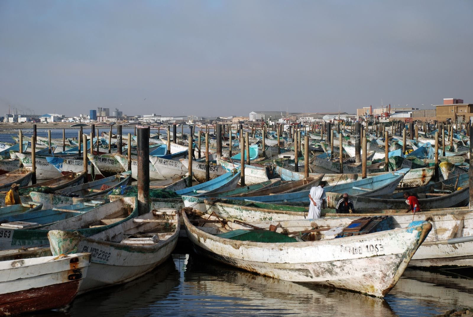
Dozens of weathered wooden fishing boats moored close together in a harbour, with the low buildings of a town behind

Nouakchott & the Coast, Mauritania

Nouadhibou

Wooden fishing boats in the port artisanal at Nouadhibou. (Bertramz / Wikimedia Commons · CC BY-SA 3.0)

Mauritania's second city and its main fishing port, on a long desert peninsula between the Atlantic and the sheltered Baie du Lévrier in the far north. Renamed Port-Étienne under French rule in 1907, it lives off the fishing fleet and off the iron ore railed some 700 kilometres from the mines at Zouérat, and is known for the rusting ships in its bay.

Neighbourhoods

  • Town centre
    • First-time visitors
    • Restaurants
    • Close to the port

    The working heart of Nouadhibou, strung along Boulevard Médian, with the banks, offices, hotels, shops and fish traders. It is dusty, low-built and busy with lorries running to and from the harbour.

    Open in Maps
  • Numerowat
    • Local life
    • Markets

    A dense residential quarter of the town, with small shops, workshops and kitchens serving the people who work in the fishing industry. There is little for visitors to see, but it is where much of the town's daily life happens.

    Open in Maps
  • Cansado
    • Quiet and residential
    • Close to the sea

    A planned settlement a few kilometres south of the centre, laid out in the 1960s for staff of the iron-ore company, with ordered streets, villas and its own small beach. It is calmer and greener than the rest of the peninsula.

    Open in Maps
  • The port area
    • Harbour and boats
    • Local life

    The artisanal harbour and the commercial fishing port, where wooden pirogues lie stacked against the quays, ice and fuel are loaded, and the catch is sorted for the processing plants. Cameras are not welcome around the official installations.

    Open in Maps

Things to do

The port and the bay

  • Port artisanalattraction

    The small-boat harbour where the wooden pirogues of the local fleet moor by the hundred, and the catch is landed, sorted and carried off to the plants.

    Open in Maps
  • The ship graveyardattraction

    More than 300 scuttled vessels have been left in the waters off the port over the decades, reckoned the world's largest ship graveyard, their hulls rusting in the shallows.

    Open in Maps
  • Baie du Lévrierattraction

    The wide sheltered bay east of the peninsula, one of the few natural anchorages on this coast, and the reason a port grew here at all.

    Open in Maps

The peninsula

  • Cap Blanclandmark

    The rocky headland at the southern tip of the peninsula, with a lighthouse above the cliffs and long empty beaches below.

    Open in Maps
  • The Cabo Blanco monk seal colonyattraction

    The coast at the cape, on the Mauritania-Western Sahara border, holds the largest surviving colony of the Mediterranean monk seal, one of the world's rarest seals; about 300 animals were counted there in 2016.

    Open in Maps
  • The peninsula beachesbeach

    Long, wind-scoured sand beaches run down the Atlantic side of the peninsula, cold-watered and usually empty apart from fishermen.

    Open in Maps

Iron ore and the railway

  • Mauritania Railwaytransit hub

    The single 704-kilometre line, opened in 1963, that carries iron ore from the mines at Zouérat across the desert to the coast, worked by trains up to 3 km long — among the longest and heaviest in the world.

    Open in Maps
  • Point Central ore terminallandmark

    The loading terminal south of the town where the ore trains end and bulk carriers are filled; it is an industrial site, seen from the road rather than visited.

    Open in Maps

The town

  • Boulevard Médianlandmark

    The long main street of Nouadhibou, lined with shops, tea stalls, workshops and offices, and the easiest place to get a sense of the town.

    Open in Maps
  • Nouadhibou marketmarket

    The central market, selling fish, vegetables trucked from the south, dates, cloth and household goods.

    Open in Maps

Eat and drink

Long-standing places and food districts in Nouadhibou. Hours, ratings and directions come from your maps app, always current.

Food and markets

  • Nouadhibou marketmarket

    Fish from the morning's boats, vegetables and fruit trucked up from the south, dates, bread and spices, with tea stalls around the edges.

    Open in Maps
  • The fish grills by the portmarket

    Simple stands near the harbour grilling whatever has just been landed — sole, bream, mullet and sardines — served with bread, onion sauce or rice.

    Open in Maps

Where people eat

  • Boulevard Médian restaurantsneighborhood

    The main street holds most of the town's small restaurants: fish and rice, Senegalese mafé and yassa, Moroccan tagines, Lebanese grills and French-style bakeries.

    Open in Maps
  • Cansadoneighborhood

    A quieter choice of a few eating places in the planned settlement south of the centre, near its beach.

    Open in Maps

Experience Nouadhibou

History

The peninsula was a fishing ground and a landmark for sailors long before there was a town: Portuguese navigators charted Cap Blanc in the 15th century, and the bay behind it, the Baie du Lévrier, offered the only real shelter on a coast of open surf. A small fishing port held in turn by the Portuguese, the Dutch and the French was renamed Port-Étienne in 1907, after a former French minister of the colonies, using it for fishing and as a staging point on the air and sea routes down the African coast. It remained a tiny settlement of a few hundred people for decades.

Two industries made the modern town. The first was iron ore: from the early 1960s a 704-kilometre railway, opened in 1963, was driven across the desert from the mines at Zouérat to a new deep-water loading terminal at Point Central on the peninsula, and the company built the planned settlement of Cansado for its staff. The second was fish. The waters off Mauritania, fed by the cold Canary Current, are among the richest in the world, and a fleet of local pirogues and foreign trawlers grew around the port, with freezing and processing plants on shore. At independence in 1960 the town was renamed Nouadhibou.

The bay became known for a different sight. Ships that were old, seized or simply no longer worth running were abandoned in the shallows over decades, until more than 300 lay rusting in the waters off the port, reckoned the world's largest ship graveyard. From February 2006 the town also became a departure point for migrant boats making for the Canary Islands, and it remains one. In 2012 the town was made Mauritania's first free zone, an attempt to draw investment into an economy that still rests on fish and ore.

Culture & Customs

Nouadhibou is a town of arrivals. Moorish families from the desert live alongside Halpulaar, Soninke and Wolof Mauritanians from the southern river valley, and there are long-standing communities of Senegalese, Malian, Guinean and other West African workers who crew the boats and work in the processing plants. Hassaniya Arabic is the common language, with Wolof and Pulaar heard in the port and French in business.

Life is organised around work at sea and the hospitality that follows it. Three rounds of sweet green tea, brewed over coals and poured from a height, mark any pause in the day, in offices, workshops and on mats beside the boats. Dress is the Mauritanian norm — the pale daraa for men, the wrapped malahfa for women — and Friday prayer sets the shape of the week.

The town's identity is industrial and outward-looking rather than scholarly: there are no old libraries or caravan-town monuments here, and people measure the year by the fishing season, the price of octopus and the movement of the ore trains. It is also a place marked by departure — for work in Europe, for the Canary Islands by boat, or simply for Nouakchott — and by the arrival of others coming to find work in the port.

Daily Life

About 173,000 people live in Nouadhibou, making it the second city of Mauritania, though it is a fraction of the size of the capital and feels like a large town spread thinly along a windy spit of desert. Most households depend directly or indirectly on fish: the artisanal fleet of wooden pirogues, the industrial trawlers, the ice plants, the freezing and packing works, and the lorries that run the catch south to Nouakchott or out through the port.

Iron ore is the other pillar. Trains of well over a hundred wagons arrive from Zouérat at the Point Central terminal, where bulk carriers load for Europe and Asia, and the national mining company remains one of the town's biggest employers, while processing the ore is the town's largest single industry. The free zone created in 2012 offers tax advantages meant to bring new businesses to the town.

Daily rhythms follow the wind and the boats: early starts, a quiet middle of the day, and the streets busy again in the evening. Water and electricity supply, the cost of living and the state of the coastal road are constant local concerns, as are overfishing and the foreign fleets that work the same grounds. Cansado, with its ordered streets, remains the most comfortable place to live; much of the rest of the town is low-built, sandy and functional.

Food

Fish dominates, and it is fresher and cheaper here than anywhere else in the country. Grilled or fried sole, grouper, sea bream, mullet and sardines are everyday meals, and octopus — the most valuable part of the catch, most of it exported — is also eaten locally. The standard lunch is thieboudienne, rice cooked in a tomato sauce with a whole fish and vegetables, a dish shared with Senegal and prepared here with whatever the boats have landed.

The Moorish side of the kitchen brings meat and milk: goat and mutton stews with rice, camel meat, millet couscous, and méchoui, a whole lamb roasted for weddings and for Eid al-Adha. Zrig, soured milk thinned with water and sweetened, is drunk through the day, and dates from the Adrar oases are sold in the market.

Because the port draws people from across West Africa, Senegalese kitchens serve mafé, a groundnut stew, and yassa, onions and lemon with chicken or fish, while the town's small restaurants run to Moroccan tagines, Lebanese grills and French-style bread and pastries. Alcohol is illegal, so the evening drink is tea, juice or a soft drink, and a meal ends with the three glasses poured in turn.

Planning tools

Budget

Nouadhibou is a working town rather than a resort, and prices are modest: simple hotels and auberges, cheap fish meals and shared taxis. The costs that rise are a hired vehicle for the peninsula and the cape, and the long journey to or from the capital.

Daily Budget Midrange
USD 70–160 (town hotel, restaurant meals, a hired car with driver)
Daily Budget Shoestring
USD 25–45 (auberge, market and street food, shared taxis)

Bring cash; cash machines are fewer and less reliable than in Nouakchott, and euros are the easiest currency to change.

Best Time to Visit

Nouadhibou is comfortable all year, cooled by the Atlantic and the Canary Current, and rarely very hot. October to April is the pleasantest stretch, with mild days and clear air; the wind blows steadily most of the year and sea fog is common in the mornings.

Suggested Number of Days

A day or two covers the town and the harbour. Add another for the peninsula and the cape, which need a vehicle, or for travelling on by the ore railway, which sets its own timetable.

First Visit
1–2 days
With Surroundings
2–3 days

Transportation

The town is strung out along the peninsula, so shared taxis and minibuses along Boulevard Médian do most of the work, and a hired car is needed for the cape and the southern end. The paved coastal highway runs to Nouakchott, and the ore railway runs inland to Choum and Zouérat.

Agree taxi fares in advance, and expect police checkpoints on the road south and near the northern border.

Airport & Station Connections

Nouadhibou International Airport lies on the edge of the city centre, with flights to Nouakchott and some regional services. The coastal highway from Nouakchott is about 470 kilometres, five to six hours by bus or bush taxi. The iron-ore train also links the town with the interior: travellers ride free on top of the ore wagons on the long, rough run between Zouérat and Nouadhibou, or in the passenger carriages attached for the purpose. The Moroccan-controlled border crossing into Western Sahara lies about 50 kilometres north, on the route to Dakhla.

Walkability

The centre is walkable along Boulevard Médian, and the harbour is close to it, but the town stretches many kilometres down the peninsula and Cansado, the ore terminal and the cape are all well beyond walking distance. Sand, wind and heavy lorry traffic make longer walks unpleasant.

Safety

Nouadhibou is generally calm, with petty theft the main risk, particularly after dark and around the port. The peninsula is shared with Moroccan-controlled Western Sahara, and the strip of no-man's-land between the border posts to the north contains uncleared landmines; the abandoned village of Lagouira at the southern tip lies on the Western Saharan side and is not accessible. Road accidents on the coastal highway and driving at night are the greater everyday dangers.

Keep to the paved road near the northern border, avoid lonely beaches at night, and travel off-road only with a local driver. Check current official travel advice before travelling.

Climate

Mild, dry and windy — a desert coast tempered by the cold Canary Current, which keeps temperatures down, brings frequent fog and makes the sea cold for swimming. Rain is very rare.

Summer
warm rather than hot, generally about 25–30°C by day, with a steady sea breeze
Winter
mild, about 20–25°C by day, with cool nights and morning fog

Local Customs

This is a conservative Muslim town: modest dress for everyone, with local men in the daraa robe and women in the malahfa. Greetings are unhurried, the right hand is used for eating and passing things, and mint tea, poured three times, accompanies almost every meeting. Alcohol is illegal. The legacy of slavery, made a crime in 2007, remains a sensitive subject.

Do not photograph the port, the railway installations, the ore terminal, checkpoints or the border area, and ask before photographing people.

Common Payment Methods

The Mauritanian ouguiya (MRU) is used and almost everything is paid in cash. A few hotels may take cards, but this cannot be relied on; cash machines exist in the centre but can be empty or out of order, so it is usual to arrive with enough cash, in ouguiya or euros, for the stay.