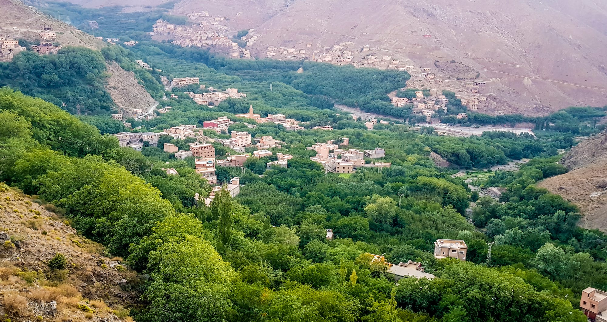
A mountain village of flat-roofed earth houses among dense green trees on a valley floor, with bare brown ridges rising behind

Marrakech & the High Atlas, Morocco

Imlil

Imlil and its walnut groves in the Mizane valley of the High Atlas. (Mounir Neddi / Wikimedia Commons · CC BY-SA 4.0)

A High Atlas village at the head of the Mizane valley, about an hour and a half south of Marrakech by road and roughly 1,800 metres above sea level. Walnut groves, terraced fields and stone-and-earth hamlets fill the valley floor, and the village works as the main base for walks between the villages and for the climb to Mount Toubkal.

Neighbourhoods

  • Imlil village centre
    • First-time visitors
    • Trek preparation
    • Close to transport

    The small square at the top of the road where grands taxis and minibuses stop, surrounded by shops selling boots, gas and dried fruit, a few cafés, guide offices and mules waiting for loads. Most guesthouses are within a few minutes' walk of it.

    Open in Maps
  • The Mizane riverbank
    • Quiet and residential
    • Views

    The terraces and walnut groves along the stream below the village, where irrigation channels feed small orchards and vegetable plots. Guesthouses here are spread among the trees, quieter than the centre and a short climb above the water.

    Open in Maps
  • Aroumd
    • Walks
    • Traditional architecture

    A stone village stacked on a spur about forty minutes' walk up the valley, above a wide stony flood plain. Its tight lanes and flat-roofed houses stand out in the valley, and it is the highest village in the Ait Mizane, on the main Toubkal path.

    Open in Maps
  • Tamatert and the upper hamlets
    • Quiet walks
    • Local life

    Small settlements on the slopes east and above Imlil, reached by mule tracks and the road over the Tizi n'Tamatert pass. They give a sense of everyday valley life — barley terraces, flocks and apple orchards — within an easy walk of the village.

    Open in Maps

Things to do

Mountains and trails

  • Mount Toubkaltrail

    At 4,167 metres the highest peak in North Africa and the Arab world, usually climbed over two days from the valley with an overnight at a mountain refuge, and normally with a licensed mountain guide.

    Open in Maps
  • Toubkal National Parkpark

    The national park around the peak, established in 1942 and covering some 380 square kilometres of high ridges, cirques and valleys reached from Imlil and neighbouring villages.

    Open in Maps
  • Sidi Chamharouchlandmark

    A small white-painted shrine and cluster of houses on the path towards Toubkal, a place of pilgrimage for Moroccan visitors and the usual first stop on the climb.

    Open in Maps
  • Tizi n'Tamatertviewpoint

    The pass on the road east of the village, a straightforward walk or drive up from Imlil with a wide view back down the Mizane valley.

    Open in Maps
  • Aroumdneighborhood

    The terraced stone village about forty minutes up the valley, above the wide gravel bed of the Mizane and beneath the walls of the Toubkal massif.

    Open in Maps

Short trips from the village

  • Asnimarket

    The nearest town, down the valley, whose Saturday souk draws farmers and traders from the surrounding mountains; most of its houses were destroyed in the 2023 earthquake.

    Open in Maps
  • Ourika valleyattraction

    The next valley east, greener and busier with day visitors from Marrakech, ending at the village of Setti Fatma and its waterfalls.

    Open in Maps
  • Oukaïmedenattraction

    The ski station and summer pasture on the plateau to the north-east, reached by road through the Ourika valley or on foot over the passes.

    Open in Maps

Eat and drink

Long-standing places and food districts in Imlil. Hours, ratings and directions come from your maps app, always current.

Mountain kitchens

  • Guesthouse half-board tablesrestaurant

    Most eating in Imlil is done at the gîtes and guesthouses, which serve soup, salads, tagines and fruit to their own guests and often to walkers passing through.

    Open in Maps
  • Cafés on the village squarecafe

    Simple places around the taxi stand serving mint tea, coffee, omelettes and tagines, and used by guides and muleteers waiting for work.

    Open in Maps

Shops and produce

  • Imlil village shopsmarket

    Small general stores stocking bread, tinned food, nuts, dried fruit and gas cartridges — the last supplies before the walk up the valley.

    Open in Maps
  • Walnuts, apples and honey of the Mizane valleymarket

    The valley's own produce, sold from doorways and roadside stalls in season — walnuts from the terraces, mountain apples and cherries, and honey from the high slopes.

    Open in Maps

Experience Imlil

History

The Mizane valley has been farmed for centuries by Amazigh families who built terraces along the stream, dug seguias to carry meltwater to them and put their flat-roofed houses of stone and rammed earth on the slopes above the good land. Grain, walnuts and grazing supported a scattering of hamlets, and Imlil was one among several rather than the centre it became. The valley lay within the reach of the Glaoua family, the "lords of the Atlas" who dominated the southern mountains under the French protectorate, and passes such as the Tizi n'Tamatert carried trade and tribute between valleys long before there was a road.

Climbing changed the village. The first recorded ascent of Toubkal, by a French party in 1923, opened the massif to mountaineers, and after independence the building of the road up from Asni made Imlil the natural roadhead for the peak. A national park was declared around the peak in 1942, a refuge was built below the summit, and the number of local guides and muleteers grew; in the second half of the 20th century families began converting houses into gîtes. Imlil itself is a comparatively recent village, built up to serve the walkers passing through, while the older communities remain in the hamlets around it.

The recent past has been hard. On 8 September 2023 an earthquake centred in Al Haouz province, the administrative district that contains the valley, killed nearly 3,000 people and destroyed many High Atlas villages; roads and tracks were damaged and rebuilding has been slow, with families in the worst-hit places still waiting for permanent homes. Trekking, the valley's main income, has continued alongside that recovery.

Culture & Customs

Imlil is a Tashelhit-speaking Amazigh village, and almost everything about daily manners follows from that. Arabic and French are understood, and guides often speak English or Spanish as well, but the language of the terraces and the kitchen is Tashelhit. Households are close-knit, work is shared between neighbours at harvest and building time, and irrigation water is divided by long-established turns that predate any written rule.

Mountain traditions are still visible. Communal granaries, mule paths and flat roofs used for drying grain and fruit belong to a way of life organised around snowmelt and the seasons, and village celebrations — weddings above all — are marked with ahwach, the collective dance of the western Atlas, performed to frame drums with lines of men and women facing each other. The shrine at Sidi Chamharouch, on the path towards Toubkal, draws Moroccan pilgrims who come for healing and blessing rather than for the summit.

Guiding has become a culture of its own. Many men in the valley are trained mountain guides, muleteers, cooks or refuge staff, and the village square works as a hiring hall where work is allocated and routes are discussed. Visitors are treated with practised hospitality — tea on arrival, insistence on feeding people properly — while the conservatism of a farming village remains: modest dress, restraint in public between couples, and a strong preference for being asked before a camera is pointed at anyone.

Daily Life

A few thousand people live in Imlil and the hamlets around it, in an administrative district of Al Haouz province where the population is spread between many small settlements rather than gathered in one town. Farming still underpins the valley — walnuts, apples, cherries, barley and maize on the terraces, sheep and goats on the slopes — but tourism now provides much of the cash income, through guesthouses, guiding, portering, mules and the shops around the square.

The day begins early. Mules are loaded at first light for the refuge and the higher hamlets, walkers set off before the heat, and women carry fodder and water along the terrace paths. The middle of the day is quiet, and the square fills again in the late afternoon as groups come down from the mountain. Children walk or are driven to schools down the valley, and a clinic and small shops cover everyday needs, with anything larger requiring a trip to Asni or Marrakech.

The pressing issues are those of a mountain community: rebuilding after the 2023 earthquake, the state of the roads and tracks, water for irrigation in dry years, and the dependence of nearly every household on a trekking season that can be disrupted by weather or by events far away. Younger people often work seasonally in Marrakech and return for the harvest.

Food

Food in the valley is simple and filling, and most visitors eat it at a guesthouse table. The standard sequence is harira or a vegetable soup, a salad of tomato, cucumber and onion, then a tagine — vegetables with a little mutton or chicken, cooked slowly over gas or charcoal — with round khobz bread torn up to scoop it, and fruit or yoghurt afterwards. Couscous appears on Fridays and on occasions, steamed above a broth of meat and vegetables.

Mountain ingredients give the valley's cooking its character. Walnuts, apples, cherries and quinces come from the terraces, barley is ground for bread and for couscous, and almonds and argan oil arrive from lower country to make amlou, the sweet spread eaten at breakfast with honey. Berkoukes, a pasta of rolled grains cooked like a thick soup, and tagines of turnip, carrot and potato are winter staples; eggs and preserved meat fill the gaps.

Bread is baked in wood-fired ovens or on a flat pan, and msemen, the layered griddle bread, is folded around honey or jam for breakfast before a walk. Mint tea is constant and poured from height, sweet enough to work as fuel on a long day; in winter it is often made with wormwood or sage instead of mint. There is no bar culture here — alcohol is not part of village life — and water for the mountain should be treated or bought rather than taken from the streams.

Planning tools

Budget

Imlil is inexpensive compared with Marrakech. Gîtes and family guesthouses charge modest rates, often with dinner and breakfast included, and the real costs of a visit are the guide, the mule and the refuge for anyone going high. Transport from Marrakech by shared taxi is cheap; a private transfer costs several times as much.

Daily Budget Midrange
USD 90–200 (comfortable guesthouse, a licensed guide and mule for the day, private transfer from Marrakech)
Daily Budget Shoestring
USD 25–50 (gîte bed with half board, café meals, shared taxi from Asni)

Agree the price of a guide, a mule and a transfer before setting out, and take enough cash from Marrakech, as banking services in the valley are minimal.

Best Time to Visit

April to June and September to October are the best months for walking, with mild days, flowing streams and the valleys green. July and August are hot on the approach but far cooler than Marrakech and popular with Moroccan visitors. From roughly November to April the high ground carries snow, which turns Toubkal into a winter climb needing crampons, an ice axe and a guide.

Suggested Number of Days

A night or two is enough for the village and short valley walks. The Toubkal ascent normally needs two days with a refuge overnight, and longer circuits between the valley villages take three or four; acclimatising to the altitude argues for the longer stay.

First Visit
1–2 days
With Surroundings
3–4 days

Transportation

There is no bus into the village. Grands taxis and minibuses run from Marrakech to Asni, where shared transport continues the last stretch up the valley, and many visitors arrange a transfer through their guesthouse. Above Imlil the road ends: paths, mules and porters take over, and a few rough tracks reach hamlets by four-wheel drive. Mountain roads are narrow and slow.

Luggage can be carried up to the higher hamlets by mule, arranged at the village square; walking poles and proper boots matter more here than any vehicle.

Airport & Station Connections

Marrakech is roughly an hour and a half away by road, normally via Asni on the Tizi n'Test road; Marrakech Menara Airport is the nearest airport. Shared grands taxis make the trip in stages, private transfers go door to door, and hire cars can reach the village square, where they must be parked.

Walkability

Everything in the village is walked, but nothing here is flat: lanes climb steeply between houses and terraces, surfaces are stone, dust or mud, and the altitude of about 1,800 metres makes short climbs harder than they look. Aroumd is about forty minutes away on a good path; the walk to the pass above the village takes rather longer.

Safety

The mountains are the risk rather than crime, which is rare in the valley. Altitude, cold, sudden storms and snow on Toubkal have caused deaths, and flash floods can fill the streams after heavy rain. Some valley tracks were damaged by the September 2023 earthquake centred in Al Haouz province, which destroyed many mountain villages, and rebuilding continues.

Use official guides booked through a riad or a licensed agency, keep bags across the body in medinas, and avoid the cannabis-growing Ketama area of the Rif. Check current official travel advice before travelling.

Climate

A mountain climate, cooler and wetter than the plain below. Days are sunny for most of the year, nights are cold in every season, and the difference between sun and shade is sharp. Most precipitation falls between November and April, as snow on the higher ground.

Summer
warm days of roughly 25–30°C in the valley and much cooler high up, with cold nights and occasional afternoon storms
Winter
cold — valley days around 8–12°C, nights below freezing, and snow on the passes and peaks from about November to April

Local Customs

This is an Amazigh farming valley where Tashelhit is the first language and life is conservative. Modest dress — covered shoulders and knees for both men and women — is expected away from the high mountain paths. Greetings and tea come before business, and hospitality is taken seriously. Ask before photographing people, houses or women working in the fields.

Tip guides, muleteers and cooks at the end of a trek; alcohol is not sold in the village and is best not brought openly; during Ramadan many households fast while still cooking for guests.

Common Payment Methods

The currency is the Moroccan dirham. Cash is the rule: guides, mules, gîtes, shops and refuges almost all expect notes, and cards are taken by only a few of the larger guesthouses. Cash machines are limited in the valley, so draw money in Marrakech or Asni before coming up.