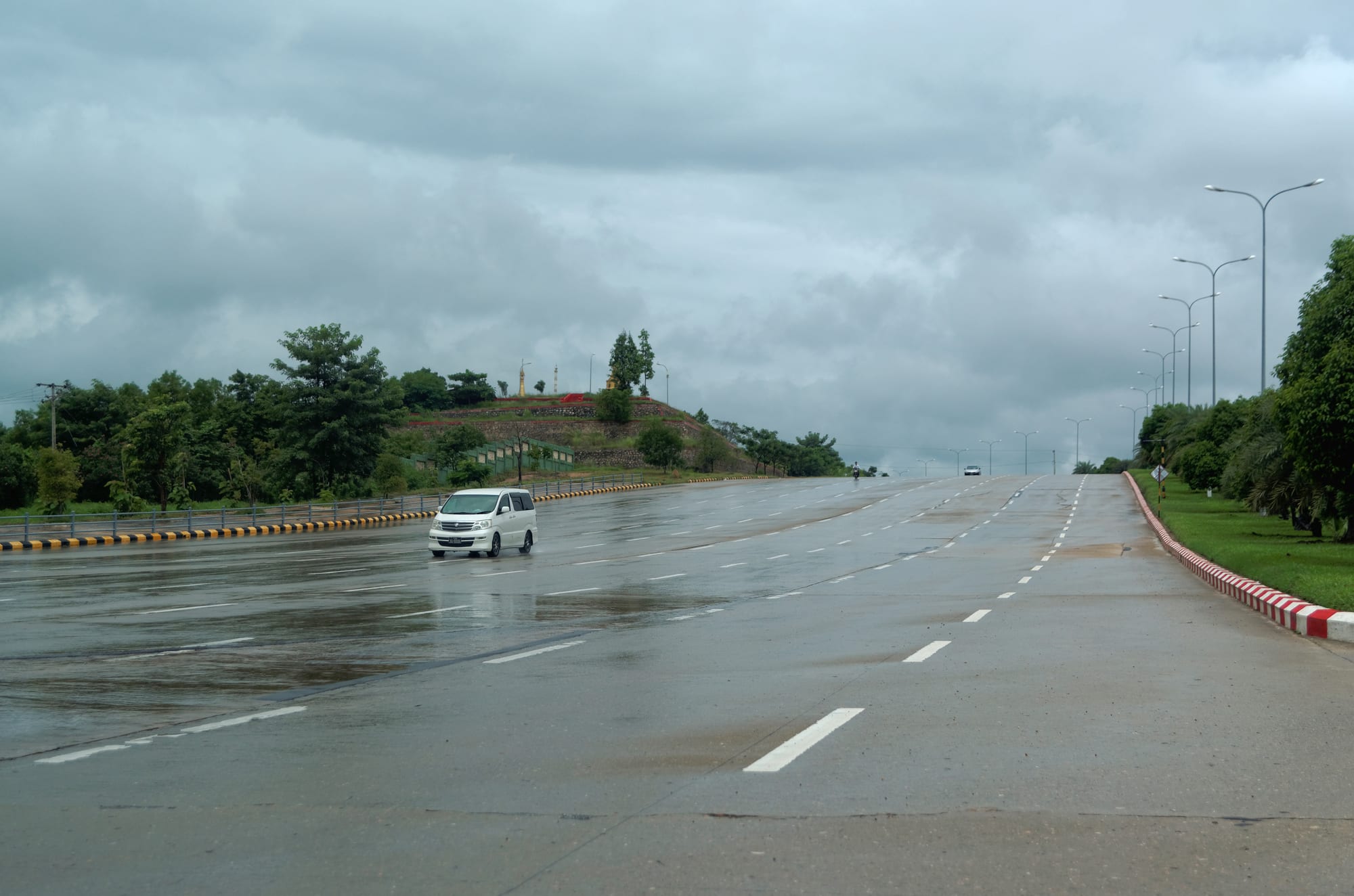
A wide multi-lane highway wet with rain, almost empty apart from one white van, with street lamps and trees along the verge

Yangon, Mandalay & Central Myanmar, Myanmar

Naypyidaw

One of the multi-lane roads that link the zones of Naypyidaw. (Jakub Hałun / Wikimedia Commons · CC BY-SA 4.0)

The purpose-built capital of Myanmar, laid out in scrubland near the town of Pyinmana and declared the seat of government in 2005. It is a city of separated zones — ministries, parliament, hotels, housing and a pagoda modelled on the Shwedagon — connected by multi-lane roads that carry little traffic. This page is written to explain the city, not to encourage travel.

Neighbourhoods

  • Pyinmana
    • Local life
    • Best for food
    • Markets

    The older market town a few kilometres east of the new capital, absorbed into it when the city was built. Narrow streets, a produce market, teashops and small restaurants make it the one part of Naypyidaw that feels like an ordinary Burmese town.

    Open in Maps
  • The hotel zone
    • First-time visitors
    • Quiet and residential

    A district of large, widely spaced hotels built along a boulevard for state visits and conferences, with gardens, golf courses and little else within walking distance. Most visitors stay here because there is nowhere else set up for them.

    Open in Maps
  • The ministry zone
    • Architecture
    • Government district

    Rows of identical ministry buildings in matching colours, set far back from the road across lawns and car parks, with the parliament complex and government offices beyond. Photography of these buildings is not permitted.

    Open in Maps
  • The residential zones
    • Quiet and residential
    • Local life

    Blocks of low-rise flats built for civil servants, colour-coded by ministry, together with markets, schools and clinics. They are the most populated part of the capital and lie several kilometres from the government offices.

    Open in Maps

Things to do

Landmarks

  • Uppatasanti Pagodalandmark

    A gilded stupa completed in 2009 and modelled closely on the Shwedagon, a little lower than the original, with a hollow interior lined with jade and carved panels.

    Open in Maps
  • National Landmark Gardenpark

    A large park with scale models of famous buildings and natural features from across the country, laid out as a map of Myanmar.

    Open in Maps
  • Naypyidaw Water Fountain Gardenpark

    A landscaped park of fountains, lawns and lit displays, one of the few public leisure spaces in the central zones.

    Open in Maps

Museums and parks

  • Defence Services Museummuseum

    A large military museum of halls and outdoor displays run by the armed forces, in the government area of the capital.

    Open in Maps
  • Naypyidaw Zoological Gardensattraction

    A zoo opened in 2008, stocked in part from the old Yangon zoo, with an air-conditioned penguin house among its enclosures.

    Open in Maps
  • Ngalaik Lakepark

    A reservoir outside the city, built in the 1980s for irrigation, with rowing boats and a shoreline that draws weekend visitors from the capital.

    Open in Maps

Getting there and around

  • Naypyidaw International Airporttransit hub

    A large airport about 16 kilometres south-east of the centre, opened in 2011 and handling few flights relative to its size; its control tower collapsed in the earthquake of March 2025 and the airport reopened in early April.

    Open in Maps
  • Yangon–Mandalay Expresswaytransit hub

    The 587-kilometre expressway that passes the capital, four lanes for most of its length, completed in 2010 as the main overland link between the country's two largest cities and the route most road travellers use.

    Open in Maps

Seasonal events

  • Thingyanmid-April

    The Burmese new year water festival, marked with stages and water throwing in Pyinmana and the residential zones during the hottest weeks of the year.

  • ThadingyutOctober

    The festival of lights ending Buddhist Lent, when houses, offices and the Uppatasanti Pagoda are lit with candles and lamps.

  • Independence Day4 January

    The national holiday, marked in the capital with official ceremonies and parades in the government zones.

Eat and drink

Long-standing places and food districts in Naypyidaw. Hours, ratings and directions come from your maps app, always current.

Where to eat

  • Pyinmana market and streetsmarket

    The old town's produce market and the noodle shops, teashops and grills around it, the most varied and least expensive eating in the capital.

    Open in Maps
  • Thapyaygone Market areaneighborhood

    A market and shopping area serving the residential zones, with food stalls, Burmese restaurants and barbecue places used by civil servants and families.

    Open in Maps
  • Hotel zone restaurantsneighborhood

    Burmese, Chinese and Thai dining rooms attached to the large hotels, convenient but expensive by local standards and quiet outside conference seasons.

    Open in Maps

Local dishes

  • Dry-zone curries and laphet thokerestaurant

    Burmese curries cooked in groundnut or sesame oil with rice and side dishes, and the fermented tea-leaf salad eaten across the country.

    Open in Maps
  • Teashopscafe

    Sweet milk tea, free green tea and fried snacks at low tables; the teashop is where business and gossip happen here as everywhere in Myanmar.

    Open in Maps

Experience Naypyidaw

History

Naypyidaw exists because the government decided in the early 2000s to move the capital out of Yangon. Construction began in secret in 2002 in scrubland and farmland near Pyinmana, a market town on the Yangon–Mandalay road about 320 kilometres north of the old capital. On 6 November 2005 ministries were ordered to relocate, and civil servants were moved north in convoys of trucks at short notice; the new city was officially named Naypyidaw, "abode of kings", in March 2006, at a military parade attended by the leadership.

Explanations for the move have varied. Official statements stressed the central location, better access to the whole country and room to grow; observers pointed to the vulnerability of a coastal capital, the protests that had repeatedly centred on Yangon, and a long Burmese tradition of founding new royal capitals. The site had a historical echo of its own: Pyinmana had been a base for Aung San's forces in the Second World War.

The city was built in separated zones on a very large footprint, the union territory covering more than 7,000 square kilometres, with wide highways, a parliament complex in Burmese royal style, ministry blocks, hotels, a zoo, a safari park and golf courses. The Uppatasanti Pagoda, modelled on the Shwedagon, was completed in 2009. Foreign embassies largely stayed in Yangon, and the capital has remained thinly populated relative to its plan. It hosted South-East Asian summits and the 2013 South-East Asian Games. After the coup of February 2021 it became the centre of the military government, and the earthquake of March 2025 damaged buildings and infrastructure across the area.

Culture & Customs

Naypyidaw has little of the layered culture of Yangon or Mandalay, because it has existed for less than a generation and was assembled from people posted here rather than born here. Its character is that of a civil-service town: government offices set the hours, ministry housing sorts neighbours by department, and conversation in public keeps well clear of politics. Formality is greater than elsewhere, and uniforms, official cars and ceremonial occasions are part of the scenery.

What cultural life exists is largely Buddhist and Burmese in the mainstream sense. The Uppatasanti Pagoda is the focus of merit-making, with alms rounds, full-moon observances and festival lights, and white elephants, traditional symbols of royal legitimacy, are kept in an enclosure beside it. Thingyan, Thadingyut and the pagoda's own festival are observed much as in other towns, though on a smaller scale.

Older culture belongs to Pyinmana, which had markets, monasteries and a timber trade long before the capital arrived, and where the annual round of temple festivals and market days continues. Newcomers from across the country have brought regional food and dialects with them, so the capital's teashops and markets mix Bamar, Shan and Chinese cooking without any one tradition dominating. The city is often described by visitors as eerily empty, an impression the scale of the roads and the separation of the zones make hard to avoid.

Daily Life

Official figures put the population of the Naypyidaw Union Territory at around a million, but that covers a very large area including Pyinmana, Lewe, Tatkon and surrounding farmland; the built capital itself holds far fewer, and its central zones can appear deserted. Most residents are civil servants, soldiers, police and their families, housed in blocks of flats allocated by ministry and distinguished by roof colour, together with the construction workers, drivers, cleaners and market traders who serve them.

The economy is government. Ministries, the parliament, the armed forces and the services attached to them provide most employment, supplemented by construction, hotels and agriculture in the surrounding countryside, where rice, sugarcane and vegetables are grown. There is no significant industry and little private commerce outside Pyinmana and the market areas.

Daily life is shaped by distance. Almost nothing is within walking range, so residents depend on motorcycles, shared cars and ministry buses, and shopping happens at a few markets and malls. Offices keep regular hours, streets empty after dark, and social life is domestic. Since 2021 power cuts, fuel shortages, price rises and internet restrictions have affected the capital as they have the rest of the country, and the 2025 earthquake added structural damage, repairs and displacement to that list.

Food

There is no distinct Naypyidaw cuisine. The capital eats the food of central Myanmar, cooked in groundnut and sesame oil: curries of chicken, pork, mutton or freshwater fish simmered until the oil separates, served with rice, a clear soup, boiled vegetables and a relish based on ngapi, the fermented fish or shrimp paste. Laphet thoke, the fermented tea-leaf salad with fried beans, peanuts, sesame and garlic, is on almost every table.

Because its residents came from everywhere, the city's eating places reflect the country as a whole. Mohinga, the fish and rice-noodle breakfast soup, is sold in the markets; Mandalay's noodle salads and Shan noodles from the eastern hills appear alongside them; and Chinese noodle houses and barbecue stalls fill the evenings in Pyinmana and the market districts. Indian-influenced dan bauk biryani and palata bread are found in the same streets.

Teashops are the social institution, as in every Burmese town: sweet, strong milk tea with condensed milk, plain green tea served free, and plates of samosas, fritters and steamed buns. The surrounding dry-zone countryside supplies toddy palm jaggery, tamarind, groundnuts and sesame, sold at the markets, and in the hot months vendors sell shaved ice, falooda and fresh sugarcane juice along the roadsides.

Planning tools

Budget

Naypyidaw's hotels were built for state guests and conferences and are often nearly empty, so rates can be low for the size of room, but the city has few cheap guesthouses. Transport is the hidden cost, since nothing is within walking distance and taxis are hired for long distances. Prices are unpredictable because of inflation and multiple exchange rates.

Daily Budget Midrange
USD 70–160 (hotel, restaurants, a car with driver, a domestic flight)
Daily Budget Shoestring
USD 25–45 (simple hotel in Pyinmana, teashops and market food, shared transport)

Bring clean US dollar notes, as foreign cards and ATMs generally do not work, and agree a daily rate with a driver rather than paying per trip.

Best Time to Visit

November to February, when days are warm and dry and mornings cool. March to May is very hot, often above 40°C, and the monsoon from June to October brings heavy rain and humidity. Any visit must be weighed against official travel advice, and access to government areas is restricted at all times.

Suggested Number of Days

One day is enough for what is open to visitors in the capital, since the sights are few and far apart. Two allow the older town and the nearby countryside as well. Distances, not the number of places, set the pace here.

First Visit
1 day
With Surroundings
2 days

Transportation

There is no public transport worth the name, no metro and few buses; the city was designed around private cars and motorcycles. Taxis and hired cars with drivers are the practical option, and motorcycle taxis operate in Pyinmana and the residential zones. Roads are wide, well surfaced and lightly used, and distances between zones run to many kilometres.

Hire a car and driver by the day, keep water in the vehicle, and expect fuel shortages and checkpoints to affect journeys.

Airport & Station Connections

Naypyidaw International Airport lies about 16 kilometres south-east of the central zones, with limited domestic and occasional regional flights. The Yangon–Mandalay Expressway passes the city, putting Yangon roughly four to five hours away by road and Mandalay a similar distance, and buses stop at a highway terminal outside the centre. The railway between Yangon and Mandalay also serves the capital. All journeys are subject to checkpoints, fuel shortages and cancellations.

Walkability

Naypyidaw is among the least walkable cities anywhere. Zones are separated by several kilometres of highway, pavements are intermittent, shade is scarce and the heat is severe for much of the year, so almost no journey can reasonably be made on foot. Pyinmana's older streets are the exception and can be walked end to end.

Safety

Most governments advise against all or all-but-essential travel to Myanmar, and the capital is not an exception. Security is heavy, government zones are closed to the public, photography of official buildings is prohibited, and checkpoints control movement. The March 2025 earthquake caused heavy damage in and around the city. Street crime is rare, but power cuts, internet restrictions and sudden road closures are routine.

Do not travel against official advice, avoid photographing soldiers, checkpoints or government buildings, and keep in contact with the relevant embassy in Yangon. Carry documents, keep away from damaged buildings, and follow any instruction given at a checkpoint. Check current official travel advice before travelling.

Climate

The capital sits at the southern edge of the dry zone, between the wet delta and the arid centre, with a hot season, a monsoon and a dry, cooler winter.

Summer
very hot, commonly 36–41°C in April and May, followed by a humid monsoon from June to October
Winter
warm and dry, about 28–32°C by day, with mornings around 15–18°C

Local Customs

This is a government city, and caution about officialdom is the norm: people avoid political conversation, and photography near ministries, parliament and military sites is not allowed. Pagoda etiquette applies as elsewhere — shoes and socks off, shoulders and knees covered — and the longyi is standard dress in offices as well as at home.

Never photograph government buildings, soldiers or checkpoints, ask before photographing people, and keep political opinions private in public places.

Common Payment Methods

The currency is the kyat, and foreign cards and international ATM networks generally do not work, so visitors carry clean US dollar notes and change them as needed. Larger hotels may quote in dollars; markets, taxis and everyday spending are in kyat, which means carrying substantial bundles of notes.