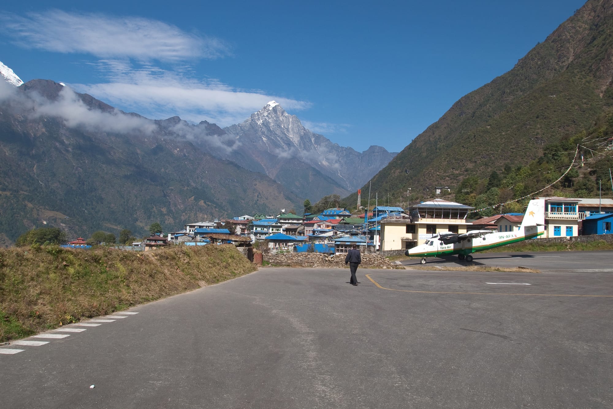
A small propeller aircraft parked on Lukla's apron beside blue-roofed lodges, with a snow peak rising above the valley beyond

Everest & Eastern Nepal, Nepal

Lukla

The apron at Lukla's airstrip, with the town's lodges and the mountains of the Dudh Koshi valley behind. (Vyacheslav Argenberg / Wikimedia Commons · CC BY 4.0)

A mountain town on a shelf at about 2,860 metres above the Dudh Koshi in the Solukhumbu district of north-eastern Nepal. Its short sloping airstrip, built in 1964 with Edmund Hillary's backing, made the Khumbu reachable from Kathmandu in a morning, and the town lives on the trekkers, guides and porters who begin and end the walk towards Everest here.

Neighbourhoods

  • The airstrip and the main street
    • First-time visitors
    • Close to public transport
    • Best for food

    The single paved lane running north from the terminal gate, lined with lodges, bakeries, gear shops and trekking offices. It is busy from dawn, when aircraft land in the calm morning air, and quiet by mid-afternoon once the day's walkers have left.

    Open in Maps
  • The upper town and the gateway
    • Quiet and residential
    • Walks

    The northern end of the street, where a carved arch marks the start of the trail to the Khumbu and a small gompa and mani walls stand among houses. Lodges here are calmer and look out over terraced fields towards the peaks.

    Open in Maps
  • Chaurikharka
    • Local life
    • Quiet and residential

    The older farming settlement on the slopes below the airstrip, in the former village committee of the same name that once included Lukla. Stone houses, potato and barley fields, a school and a monastery give a picture of Solukhumbu life away from the trekking street.

    Open in Maps

Things to do

In the town

  • Tenzing-Hillary Airporttransit hub

    The short runway cut into the hillside at a steep gradient, named after the first climbers of Everest and among the most talked-about airstrips in the world.

    Open in Maps
  • Chaurikharkaneighborhood

    The farming village below the airstrip, with fields, a monastery and a school, giving a sense of how the area lived before the runway was built.

    Open in Maps

Along the trail north

  • Phakdingneighborhood

    The riverside village a few hours down the valley where most walkers spend their first night on the way to Namche.

    Open in Maps
  • Sagarmatha National Parkpark

    The UNESCO World Heritage park covering the Everest region, entered at Monjo on the trail north of Lukla.

    Open in Maps
  • Namche Bazaarneighborhood

    The Sherpa market town about two days' walk up the valley, the main acclimatisation stop and the commercial centre of the Khumbu.

    Open in Maps
  • Tengbochelandmark

    The largest monastery in the Khumbu, on a ridge facing Everest and Ama Dablam, reached on the trail beyond Namche.

    Open in Maps

Peaks in view

  • Kusum Kanguruviewpoint

    The sharp triple-summited peak of 6,367 metres east of the town, classed as a trekking peak but among the hardest in Nepal to climb.

    Open in Maps
  • Kongde Riviewpoint

    The long ridge of rock and snow up the valley to the north, seen on clear mornings from the trail above the town.

    Open in Maps

Seasonal events

  • LosarFebruary or March

    The Tibetan new year, kept in Sherpa households and monasteries with cleaning, feasting and rituals, in the quiet season between the trekking rushes.

  • Mani Rimdu at TengbocheOctober or November

    Masked dances and Buddhist ceremonies at Tengboche monastery up the valley, which many autumn trekkers time their walk around.

  • DashainSeptember or October

    Nepal's longest festival, when lodge staff and porters from the lower hills return home and the town can be short of workers.

Eat and drink

Long-standing places and food districts in Lukla. Hours, ratings and directions come from your maps app, always current.

Lukla staples

  • Lodge dining rooms on the main streetrestaurant

    Teahouse kitchens serving daal bhaat, momo dumplings, thukpa noodle soup, fried potatoes and eggs to trekkers waiting for flights or setting out.

    Open in Maps
  • Lukla's bakeries and coffee housescafe

    Small bakeries along the street sell apple pie, cinnamon rolls, bread and coffee, a staple of mornings spent waiting on the weather.

    Open in Maps
  • Shops and stalls by the airport gatemarket

    General stores selling biscuits, chocolate, instant noodles, batteries and trekking supplies carried up from the road head or flown in.

    Open in Maps

Experience Lukla

History

Lukla was a modest Sherpa settlement of fields and grazing on a shelf above the Dudh Koshi until the middle of the twentieth century, its people part of the farming community of Chaurikharka on the slopes below. The valley's traffic ran north to south on foot, between the high Khumbu villages and the markets of the lower hills, and a walk from the Kathmandu road took the better part of a week.

That changed in 1964, when Edmund Hillary, whose Himalayan Trust was building schools and clinics in the Khumbu, arranged the construction of an airstrip here to carry materials in. He bought the land from local Sherpas, who helped build the strip, and the surface is said to have been levelled by villagers stamping it down. The runway is 527 metres long and rises at a gradient of nearly 12 per cent, ending against the mountainside; it was paved in 2001. In 2008 it was renamed Tenzing-Hillary Airport after the two men who first climbed Everest.

The airstrip turned a farming hamlet into the gateway of the Everest region. Trekking grew through the 1970s and 1980s, and the single street filled with lodges, shops and agency offices; by the busiest autumn mornings the airport handles a steady stream of small aircraft and helicopters. Accidents and cancellations have given it a reputation for difficulty, and repeated attempts to spread traffic, including seasonal transfers of flights to Ramechhap, have changed how visitors reach it. The 2015 earthquake damaged buildings in the district and briefly halted the trekking season, and the town rebuilt quickly.

Culture & Customs

Lukla is a Sherpa town on the Tibetan Buddhist side of Nepal's religious map, and the marks of that are on the street itself: a carved arch at the top of the village, mani walls with the mantra om mani padme hum, chortens, a gompa and prayer flags strung from the rooftops. Walkers pass these on the left, and monastery ritual follows the Nyingma tradition, with Losar in late winter the main household festival and the Mani Rimdu dances at Tengboche the best-known public one.

It is also a working town of the trekking economy, and its culture reflects that. Guides, porters, lodge keepers, pilots, helicopter crews and rescue workers pass through in numbers, and the conversation on the street is about weather windows, loads and flight manifests. Many of the staff are seasonal migrants from the lower hills and the Rai and Tamang districts to the south, so Nepali is the common working language alongside Sherpa, and English is widely spoken.

Manners are those of the Khumbu: understated hospitality, tea offered to visitors, quiet reserve on first meeting. Climbing has given the area a strong sense of its own record, and memorials to Sherpa climbers and to those lost in the mountains stand in the district. Visitors who make an effort with a greeting of namaste, ask before taking photographs and treat porters and staff with respect are met warmly.

Daily Life

A few thousand people live in Lukla and the surrounding Chaurikharka area, within Khumbu Pasanglhamu Rural Municipality. The rhythm of the day is set by the weather and the aircraft: flights come in from first light while the air is calm, the street fills with arriving and departing groups through the morning, cloud closes in around midday, and by late afternoon the town is quiet with lodges cooking for the night.

Almost every household depends on visitors in some way — lodges, shops, bakeries, portering, guiding, airport work, freight handling. Farming continues below the town, with potatoes, barley and buckwheat and some cattle and crossbred yaks, and families run both at once. Schools and a health post serve the area, and serious cases are flown to Kathmandu.

The town is busy for perhaps six months of the year and near-empty in the monsoon and deep winter, when many workers go home to lower villages or to the capital. Electricity comes from small hydropower schemes and solar panels, and supplies arrive by air or on the backs of porters and animals. The shared worries are the reliability and safety of the air link, the cost of everything that has to be flown in, waste disposal, and the effect of a changing climate on snow, glaciers and the trekking seasons on which the valley depends.

Food

Meals in Lukla are trekking meals. Daal bhaat is the mainstay, a plate of rice with lentil soup, curried vegetables and pickle, served with refills, and it is what most guides and porters eat twice a day. Sherpa dishes appear alongside it: thukpa, a noodle soup with vegetables or meat; shyakpa, a thicker stew with hand-cut dough; riki kur, potato pancakes eaten with butter; and momo, steamed or fried dumplings. Potatoes are the local crop and turn up boiled, fried and in soup.

Lodge menus also carry the familiar trail list of fried rice, spaghetti, pancakes and wood-fired pizza, cooked for foreign appetites and useful for calorie loading before a long walk. Lukla's bakeries are known for apple pie, cinnamon rolls and espresso, and their windows are a fixture of mornings spent waiting for a flight. Yak and nak cheese from valley dairies is sold in slabs and used in sandwiches.

Drinks run from masala tea and ginger with lemon to the Tibetan butter tea, salty with churned butter, drunk in Sherpa homes. Chhang, a cloudy beer of fermented barley or millet, and raksi, a clear grain spirit, are poured at festivals and in lodges, though alcohol is unwise for anyone about to gain altitude. Boiled or filtered water is the norm, and refill stations exist in the valley to cut the number of plastic bottles carried up and left behind.

Planning tools

Budget

Lukla is dearer than the lowlands because nearly everything arrives by aircraft or on a porter's back, and it is cheaper than the villages higher up. Rooms are inexpensive, especially when meals are taken in the same lodge, but food, charging, hot water and wifi are billed separately. The flight from Kathmandu, national park and local permits and the wages of a guide or porter are the real costs of a Khumbu trip.

Daily Budget Midrange
USD 50–130 (guided trek with a porter, a better lodge in town, bakery meals and hot showers)
Daily Budget Shoestring
USD 20–35 (lodge room, daal bhaat and tea, walking without a porter)

Keep spare cash for extra nights: a cancelled flight can strand walkers here for days, and prices do not fall when the weather closes in.

Best Time to Visit

October and November are the clearest and busiest months, and March to May is the spring season, when expeditions pass through for Everest and rhododendrons flower below the town. Winter is cold, quiet and often bright. The monsoon from June to September brings cloud, rain and the highest chance of flights being cancelled for days at a time.

Suggested Number of Days

Most visitors pass through in a morning at each end of a trek. A night here is common before an early flight, and weather can add several unplanned days, which is why trekkers are advised to keep spare time at the end of a Khumbu trip.

First Visit
1 day
With Surroundings
2 days

Transportation

There is no road to Lukla. Movement is on foot, by pack animal or by aircraft and helicopter, and the town itself is one stone-paved street. Porters and crossbred zopkio carry freight up the valley, and helicopters handle charters, rescues and heavy loads.

Step to the uphill side of the path when loaded animals pass, and expect to walk everywhere with a full pack unless a porter has been hired.

Airport & Station Connections

Flights to Tenzing-Hillary Airport from Kathmandu are short, well under an hour in small aircraft, though in the busy spring and autumn seasons many are moved to Ramechhap, several hours by road east of the capital, which means an overnight start. Helicopters fly the same route at higher cost. The alternative is to walk in from the road head at Salleri, Phaplu or Jiri, which takes several days and helps with acclimatisation.

Walkability

The town is a single street perhaps fifteen minutes from end to end, with everything on it. It is steep in places and the altitude makes short climbs feel harder than they look. There are no vehicles, and the paving is uneven and slippery after rain or snow.

Safety

Crime is rare. The known risks are the flight itself, into a short sloping runway hemmed in by terrain and subject to sudden cloud, and the altitude: at about 2,860 metres some visitors feel breathless or sleep badly, and the danger grows for anyone climbing quickly beyond the town. Trails are steep, and the monsoon brings landslides and slick paths.

Fly in the early morning when conditions are calmest, leave spare days at the end of a trek for cancellations, and carry insurance that covers helicopter evacuation. Check current official travel advice before travelling.

Climate

A temperate mountain climate, milder than the villages higher in the Khumbu. Mornings are usually clear and still, cloud builds through the middle of the day, and nights are cold for most of the year. Snow falls between December and March.

Summer
mild and wet, roughly 12–20°C by day from June to August, with cloud, rain and frequent flight disruption
Winter
cold and bright, roughly 5–12°C by day and below freezing at night from December to February

Local Customs

This is a Sherpa and Tibetan Buddhist town. Mani walls, chortens and prayer wheels are passed on the left, walking clockwise around them; prayer flags and carved stones are left untouched. Shoes are removed in monasteries and homes, dress is modest, and tipping guides and porters at the end of a trek is expected. Guides and lodge staff are used to questions and generally speak good English.

Ask before photographing people or the inside of a gompa, and carry non-degradable rubbish back out of the valley rather than leaving it with lodges.

Common Payment Methods

The currency is the Nepalese rupee. Lukla has cash machines and money changers, but machines run out of notes in the busy seasons and card terminals depend on a network that fails in bad weather. Most trekkers bring rupees from Kathmandu; above Namche almost everything is cash only.