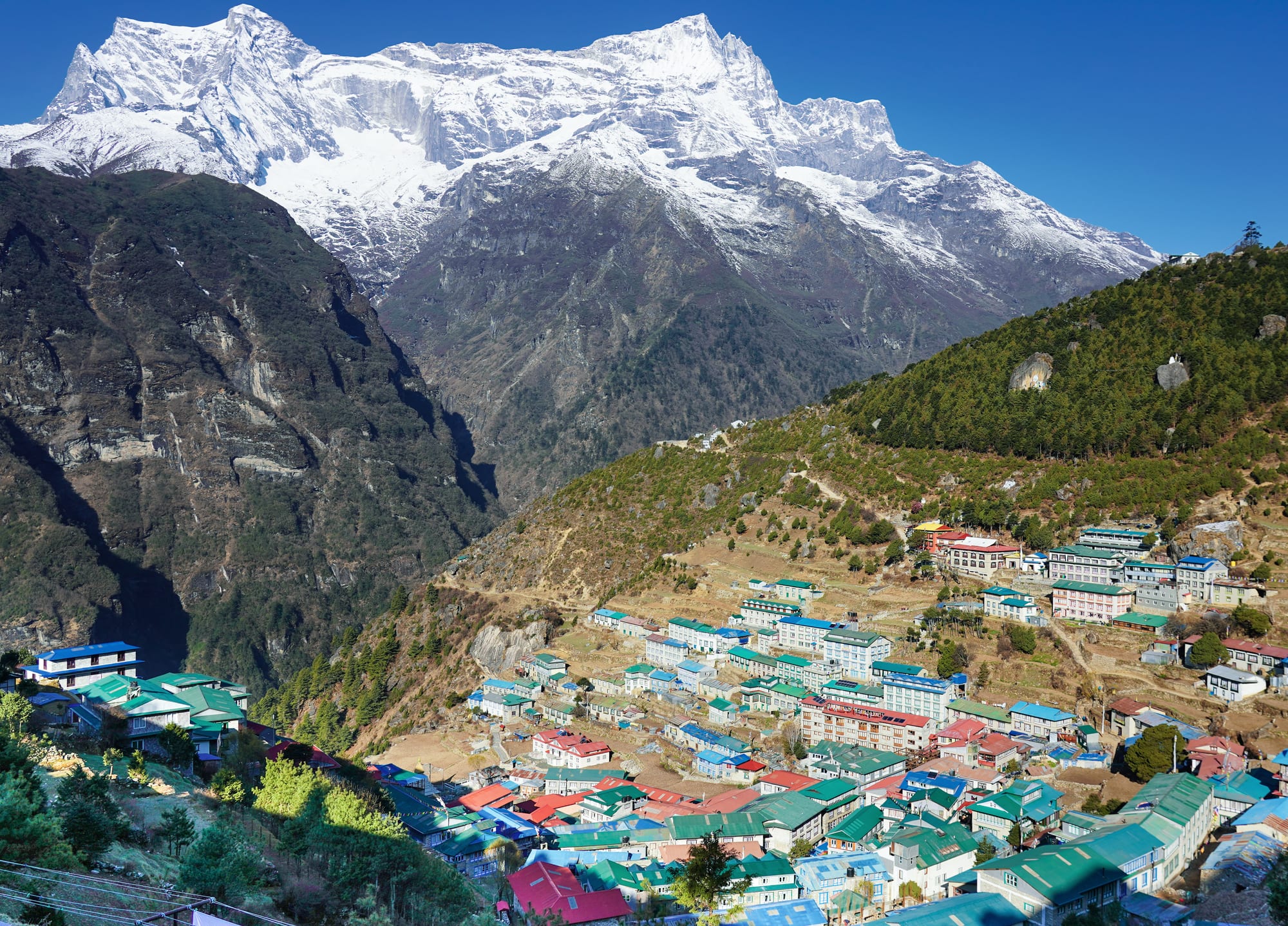
Colourful roofs of Namche Bazaar spread across a steep hillside beneath the snow-covered ridge of Kongde Ri

Nepal

Everest & Eastern Nepal

Namche Bazaar, the Sherpa trading town of the Khumbu, looking west towards Kongde Ri. (Nirojsedhai / Wikimedia Commons · CC BY-SA 4.0)

Nepal's eastern province, Koshi, climbing from the rice plains and industrial towns of the Terai around Biratnagar through Ilam's tea hills to the Khumbu, Makalu and Kanchenjunga — home of the Sherpa, Rai and Limbu peoples and of the trail to the foot of Everest.

Explore Everest & Eastern Nepal

History

The eastern hills are the land of the Kirat, the forebears of today's Rai and Limbu, whom Nepali tradition regards as among the country's earliest inhabitants. The Limbu country east of the Arun river, called Limbuwan, was ruled by its own chiefs until a war and a treaty with Prithvi Narayan Shah joined it to the Gorkha kingdom in 1774. The Shah state granted the Limbu a form of land autonomy, kipat, which survived in parts into the 20th century.

Sherpa families migrated over the passes from eastern Tibet several centuries ago and settled the high valleys of the Khumbu and Solu, trading with Tibet across the Nangpa La. Their world changed in the 1950s, when foreign mountaineers began to arrive. Tenzing Norgay and Edmund Hillary reached the summit of Everest in 1953, and Hillary went on to found the Himalayan Trust, which built schools and clinics in the Khumbu and the airstrip at Lukla in 1964.

The Terai to the south was a malarial forest until the 20th century. Biratnagar grew as an industrial town, and its jute-mill strike of 1947, led by the Koirala brothers, was an early challenge to Rana rule. From the 1990s more than 100,000 Lhotshampa refugees from Bhutan lived in camps in eastern Nepal, most of them until resettlement abroad. Under the 2015 constitution the east became Province No. 1, renamed Koshi Province in 2023.

Culture & Customs

The Rai and Limbu follow Kirat religion, organised around the oral scriptures of the Mundhum, ancestor worship and nature spirits, often blended with Hinduism. Their main festival, Udhauli and Ubhauli, marks the start of the farming year and the harvest, and the Rai dance it as sakela in large groups. The Limbu play the chyabrung, a two-headed drum slung from the neck, in a dance of the same name, and prize singing contests between young men and women. Many Gurkha soldiers were recruited from these communities, and Dharan grew around a British recruiting centre.

In the Khumbu, Sherpa life is Tibetan Buddhist. Every village has its gompa, and every trail its mani walls carved with prayers; Losar, the Tibetan new year, and Tengboche's masked Mani Rimdu dances are the main festivals. Climbing and trekking have created a professional elite of Sherpa guides and lodge owners, and the name "Sherpa" is often used loosely in the rest of the world for any high-altitude porter.

The Terai around Biratnagar mixes hill migrants with Tharu, Rajbanshi, Maithili-speaking and Muslim communities, and Chhath is celebrated on the riverbanks as in the western plains.

Daily Life

Biratnagar, the provincial capital and one of Nepal's largest cities with about 240,000 people, is an industrial and trading town near the Indian border. Itahari, at the crossroads of the East–West Highway, Dharan, a lively hill-foot town with long Gurkha ties, Damak and Birtamod in Jhapa are the other main centres. The Terai grows rice, jute and sugarcane, and many families live on remittances from the Gulf, Malaysia and the British and Indian armies.

In the hills, farmers grow maize and millet, large cardamom, of which Nepal is the world's largest producer, while Ilam's tea estates and small growers produce most of Nepal's tea. Dhankuta, Bhojpur, Khotang and Taplejung are small district towns at the end of long roads.

The Khumbu has become one of the most prosperous parts of rural Nepal thanks to tourism. Namche Bazaar holds a Saturday market where porters carry goods up from lower valleys, lodges fill each autumn and spring, and many Sherpa children study in Kathmandu. Climate change is the everyday concern: melting glaciers, rising glacial lakes, crowding on Everest and waste on the trails.

Food

The eastern hills have their own dishes. The Limbu and Rai ferment kinema, sticky soybeans with a strong smell, cooked as a curry, and brew tongba, fermented millet in a wooden vessel topped up with hot water and sipped through a bamboo straw. Millet, maize and buckwheat breads, gundruk and bamboo-shoot pickles fill out the plate.

Ilam is a food producer in its own right: it grows most of Nepal's tea, its dairies make cheese and the hard, chewy chhurpi sold as a snack, and the hills are covered with cardamom, ginger, broom grass and round chillies.

In the Khumbu, teahouses serve daal bhaat, noodle soups and trekkers' pizzas, and butter tea and chhang, a beer of fermented barley, millet or rice, remain the local drinks. The Terai eats rice, lentils, fish curries and Maithili and Bengali-style sweets.

Attractions & Natural Wonders

The Everest region, protected as Sagarmatha National Park, a UNESCO World Heritage Site, is the reason most people come. From the steep airstrip at Lukla, the trail follows the Dudh Koshi to Namche Bazaar, then climbs to Tengboche, Dingboche and Lobuche before reaching Gorak Shep, Everest Base Camp beneath the Khumbu Icefall, and the Kala Patthar viewpoint facing the summit of Everest. Side routes lead to the turquoise Gokyo lakes and over the Cho La, Renjo La and Kongma La passes, and Khumjung and Thame are quieter Sherpa villages.

Further east, the Makalu-Barun National Park protects the valleys below Makalu, the fifth-highest mountain, and the Kanchenjunga Conservation Area in Taplejung holds the two base-camp treks to the southern and northern flanks of Kanchenjunga. The hilltop shrine of Pathibhara Devi near Taplejung draws Hindu and Limbu pilgrims.

In the lower hills, Ilam's tea gardens roll across the slopes around the town, and the sunrise point of Antu Danda looks towards the Himalaya. Dhankuta and Bhojpur are old hill bazaars, and Dharan's Budhasubba temple is a local pilgrimage site.

On the plains, Biratnagar is chiefly a business city and a flight gateway, while the Koshi Tappu Wildlife Reserve on the Sapta Koshi is one of Nepal's Important Bird Areas.

Cities in Everest & Eastern Nepal

Planning basics

Budget

Costs split sharply by altitude. The Terai cities of Biratnagar, Itahari and Dharan and the tea town of Ilam are cheap, but the Everest trek is one of Nepal's more expensive, with return flights to Lukla, park fees, a guide and teahouse food whose prices rise with every day's climb. Kanchenjunga and Makalu treks need restricted-area permits and fully organised logistics.

Daily Budget Midrange
USD 50–130 (guided Everest trek with porter and better lodges, or a hotel and car in the eastern hills)
Daily Budget Shoestring
USD 15–20 in the Terai and Ilam; USD 25–40 on the Everest trail (teahouse room and meals)

Carry enough rupees from Kathmandu or Lukla; above Namche, charging, showers and wifi are paid for separately and cash is king.

Safety

Crime is low. The serious risks are altitude sickness on the Everest and Kanchenjunga treks, avalanches and cold, small-plane flying into Lukla, the long wait for rescue in remote valleys, and monsoon landslides on the roads to Ilam and Taplejung. The Terai has ordinary traffic dangers and occasional strikes.

Take acclimatisation days at Namche and Dingboche, turn back at the first serious symptoms, and carry insurance that covers helicopter evacuation. Check current official travel advice before travelling.

Climate

The east is among the wetter parts of Nepal, as rainfall decreases from east to west with distance from the Bay of Bengal. The Terai is hot and humid, the Ilam hills mild and misty, and the Khumbu cold and dry in winter, with night-time temperatures well below freezing at Gorak Shep and Everest Base Camp.

Summer
hot and humid in Biratnagar, 30–38°C; heavy monsoon rain and cloud in the hills; mild but cloudy in the Khumbu
Winter
pleasant in the Terai, 10–24°C; cold in Namche, often below −10°C at night higher up, with clear skies

Transportation

Lukla is reached by a short flight in small aircraft from Kathmandu or, in busy seasons, from Ramechhap to the south-east; the alternative is several days' walk from the road head. Biratnagar and Bhadrapur have flights from Kathmandu, and the East–West Highway links Biratnagar, Itahari and the Kakarbhitta border crossing with India. Buses and jeeps climb from Itahari and Birtamod to Dharan, Dhankuta and Ilam.

Leave at least two spare days after an Everest trek, as fog and cloud regularly cancel Lukla flights.

Best Time to Visit

October to November is the main Everest and Kanchenjunga trekking season, with the clearest views; March to May is the second season, with rhododendrons in flower and the Everest climbing expeditions at Base Camp. The Mani Rimdu festival at Tengboche usually falls in October or November. Ilam and the Terai are pleasant from October to March.