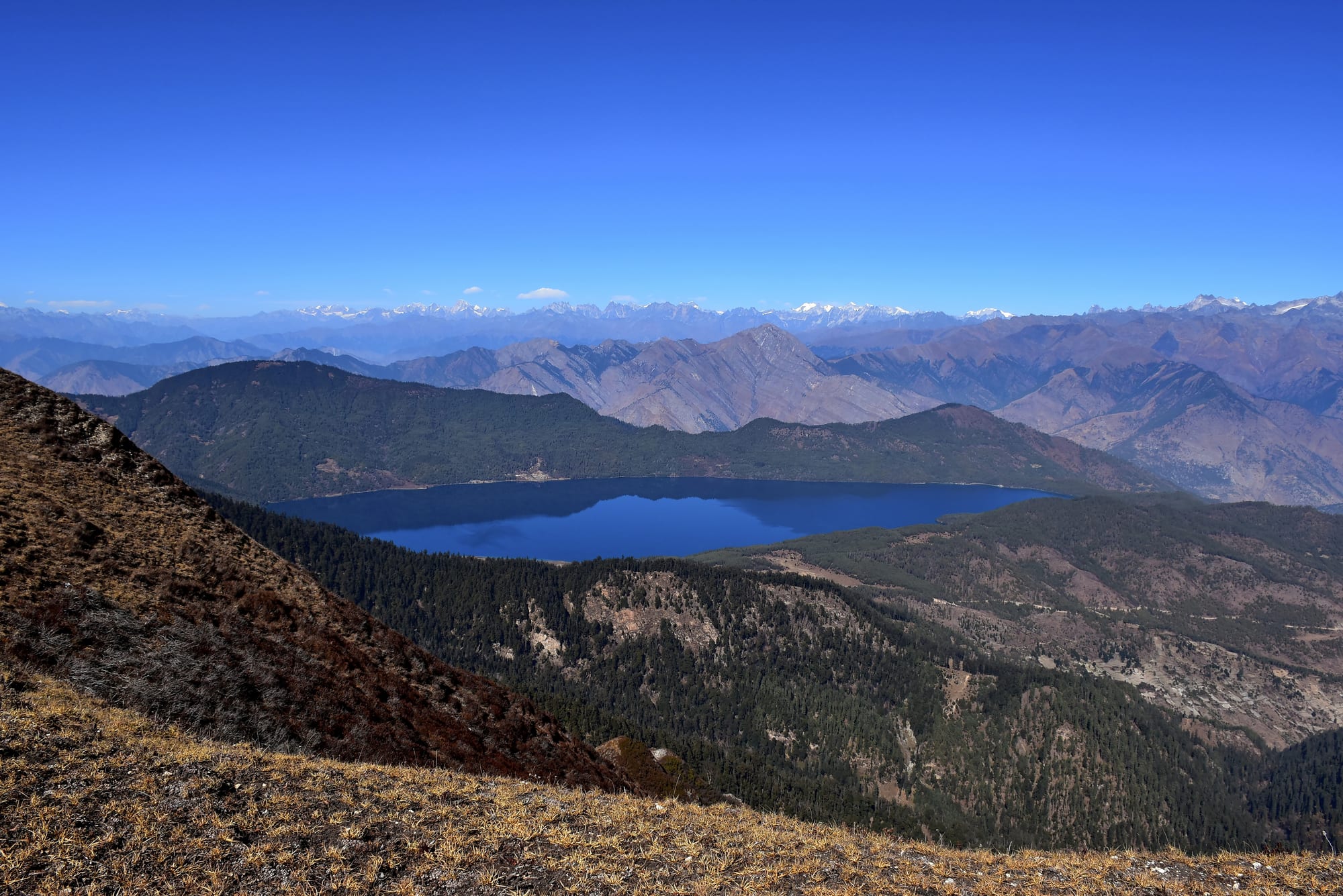
A deep blue lake set among forested ridges, with bare brown hills and a line of snowy peaks beyond under a clear sky

Nepal

Lumbini, Bardia & the West

Rara Lake in Mugu district, the largest lake in the Nepalese Himalayas, seen from the ridges above in winter. (Prabeshsdev / Wikimedia Commons · CC BY-SA 4.0)

The western half of Nepal, taking in Lumbini, Karnali and Sudurpashchim provinces — from the Buddha's birthplace and the Tharu villages and tiger forests of the western Terai up through the Mahabharat hills to Rara Lake, Dolpo and Humla, the least visited and poorest corner of the country.

Explore Lumbini, Bardia & the West

History

Lumbini is where, according to Buddhist tradition, Queen Maya Devi gave birth to Siddhartha Gautama, the future Buddha, in a garden around the 6th or 5th century BC. The Mauryan emperor Ashoka came on pilgrimage in the 3rd century BC and set up an inscribed stone pillar recording the Buddha's birth there. The site was later abandoned to the forest and was identified again in 1896, when the pillar was rediscovered. Nearby, the ruins at Tilaurakot are one of the places proposed for Kapilavastu, the city of the Buddha's father.

In the western hills a separate state rose around the 11th century: the Khas Malla kingdom, centred on the Sinja valley near Jumla, which at its height stretched into western Tibet. Its language, Khas, is the ancestor of modern Nepali. After it broke up, the region split into the Baise, or "twenty-two kingdoms", which were absorbed into Nepal in the late 18th century. Much of the far-western Terai was returned to Nepal by the British in 1860 as a reward for help during the Indian Rebellion of 1857.

The west has stayed the country's poorest region. The Maoist insurgency of 1996–2006 was fought hard in the hill districts of Rolpa and Rukum and affected much of the region. In 2000 the government abolished the kamaiya system of bonded labour, which had bound many Tharu families to landlords in the western Terai.

Culture & Customs

The Terai here is Tharu country. Dangaura Tharu in Dang and Bardia and Rana Tharu in Kailali and Kanchanpur have their own dialects, painted mud-walled houses, and festivals such as Maghi in mid-January, a major celebration in the western plains. Awadhi and Bhojpuri-speaking communities and a large Muslim population live around Nepalgunj and Kapilvastu.

In the far-western hills people speak Doteli and related dialects, and the deuda, a song and dance in which participants link arms in a circle, is the defining folk art; the Gaura festival celebrates the wedding of the goddess Gauri to Shiva. The region also carries harsher traditions: chhaupadi, the exclusion of menstruating women to sheds, has been banned by law but persists in parts of Karnali and Sudurpashchim.

Further north, Dolpo and Humla are Tibetan in language and faith. Dolpo is one of the last strongholds of Bon, the pre-Buddhist religion of Tibet, alongside Buddhist monasteries, and its caravans of yaks carrying salt and grain inspired the 1999 film Himalaya. Lumbini draws pilgrims from Sri Lanka, Thailand, Myanmar, Japan and India, and Buddha Jayanti is its main festival.

Daily Life

Most people in the west live in the Terai, where Butwal, Nepalgunj, Dhangadhi, Siddharthanagar (Bhairahawa) and Ghorahi and Tulsipur in the Dang valley are the growing centres. Butwal is a trading hub at the foot of the hills, Bhairahawa a border town facing Sonauli in India, and Nepalgunj a busy crossroads for the mountain districts. Farming of rice, wheat, lentils and sugarcane dominates, and seasonal migration to India is a way of life, especially from the far west.

Karnali is among the poorest provinces in Nepal. Birendranagar in Surkhet is its capital; Jumla and Simikot are small towns without large markets, and many hill villages are still days from a road. Families grow barley, buckwheat, beans and the famous red rice of Jumla, and in spring whole villages in Dolpo and the high pastures go up to collect yarsagumba, a caterpillar fungus prized in Chinese medicine and sold for high prices. Food shortages, poor health care and migration remain the pressing issues.

Lumbini Province's capital is Deukhuri in the Dang valley, while Sudurpashchim's is designated at Godawari in Kailali, with Dhangadhi serving as the temporary seat.

Food

The western Terai eats as the Tharu do: dhikri, steamed rice-flour dumplings shaped by hand; ghonghi, river snails cooked in a spicy broth; and fish and crab from the rivers and ponds. Pork and duck appear at Maghi feasts, and bagiya, rice and lentil dumplings, are made for festivals.

In the hills, meals turn on dhido, a thick porridge of millet, buckwheat or maize flour eaten with lentils, greens and pickles. Jumla's marsi red rice, a high-altitude variety grown there for centuries, is sold across Nepal, along with Jumla beans and apples from Karnali's orchards. Hemp seeds are ground into a tangy pickle in the far west, and nettle soup (sisnu) and wild honey come from the forests.

In Dolpo and Humla the diet is Tibetan: tsampa, barley bread, butter tea, yak cheese and dried meat. Tansen is known for its Palpali foods and sweets, and around Lumbini, simple daal bhaat and Indian-style snacks such as samosa and jalebi feed pilgrims.

Attractions & Natural Wonders

Lumbini, a UNESCO World Heritage Site, centres on the Maya Devi Temple, which protects the excavated remains of earlier shrines and the marker stone for the birth spot, beside the Ashoka pillar and the sacred Puskarini pond. A long canal runs through the monastic zone, where Buddhist countries and communities have built temples, to a Japanese-built World Peace Pagoda. The ruins of Tilaurakot and the stupas of Ramagrama lie within easy reach.

Bardia National Park, reached from Thakurdwara, is the largest national park in the Terai, where tigers, rhinos, wild elephants and, in the Karnali river, Ganges river dolphins can be seen on jeep drives, walks and rafting trips. Shuklaphanta National Park in the far west and the Tharu villages around both parks complete the lowlands. In the hills, Tansen looks out from Srinagar hill towards the Himalaya, with the Rani Mahal palace among Palpa's sights.

In the north, Rara Lake, at about 3,000 metres in Mugu, is circled by a walking trail. Dolpo holds the turquoise Shey Phoksundo Lake, the Bon village of Ringmo, and, beyond high passes in Upper Dolpo, the Shey Gompa region. The Karnali river country, from Humla's route towards Mount Kailash in Tibet to the Karnali's long whitewater descent through the hills, is Nepal's least explored landscape, and Khaptad National Park's high meadows lie in the far west.

Cities in Lumbini, Bardia & the West

Planning basics

Budget

The west is cheap on the ground but expensive to reach. Lumbini, Butwal, Nepalgunj and Dhangadhi have inexpensive hotels and eateries, and Bardia's lodges near Thakurdwara are modest in price. Remote trips to Rara, Dolpo or Humla cost far more, because they need flights to small airstrips, camping or basic lodges, guides, and restricted-area permits for Upper Dolpo and Humla.

Daily Budget Midrange
USD 40–90 (jungle lodge with guided walks, a hotel near Lumbini, private jeep transfers)
Daily Budget Shoestring
USD 10–20 (guesthouse in Lumbini or Bardia, daal bhaat, local buses)

Budget separately for mountain flights from Nepalgunj or Surkhet and for restricted-area permits in Upper Dolpo and Humla, which are arranged through agencies.

Safety

The west is peaceful, but it is the most remote part of Nepal, with basic health care, long distances between towns and few rescue options in Dolpo and Humla. Roads in the hills are narrow and prone to landslides in the monsoon. In Bardia, walking safaris bring visitors close to tigers, rhinos and elephants, and summer heat in the Terai is a real risk.

Walk in the national parks only with licensed guides, carry water and sun protection in the Terai, and take insurance with helicopter evacuation for Rara or Dolpo. Check current official travel advice before travelling.

Climate

The Terai of Lumbini, Bardia and Kailali is among the hottest parts of Nepal, with pre-monsoon temperatures above 40°C and cold, foggy winter mornings. The hills are milder, while Jumla, Rara and Dolpo are cold and dry; Dolpo and Humla lie largely in the rain shadow of the Himalaya and receive far less monsoon rain than the south.

Summer
very hot in the Terai, 35–42°C before the monsoon, then humid; mild and fairly dry around Rara and in Dolpo
Winter
pleasant days and foggy mornings in the Terai, 8–23°C; snow at Rara and in Dolpo, with passes closed

Transportation

Gautam Buddha International Airport at Bhairahawa, international since 2022, is about half an hour from Lumbini, and domestic flights also serve Nepalgunj and Dhangadhi. The East–West Highway runs the length of the Terai, with Bardia a few hours by road from Nepalgunj. Small planes fly from Nepalgunj and Surkhet to Talcha for Rara, Juphal for Dolpo and Simikot in Humla, and roads now reach Jumla.

Mountain flights in the far west are frequently delayed by weather; keep several spare days and confirm bookings the day before.

Best Time to Visit

October to April suits Lumbini and the Terai, with February to April the best months for tiger and rhino sightings in Bardia, when the grass has been cut. Rara Lake is best in April to May and October to November; Upper Dolpo, in the rain shadow, is trekked in summer and early autumn. Buddha Jayanti in spring brings pilgrims to Lumbini.