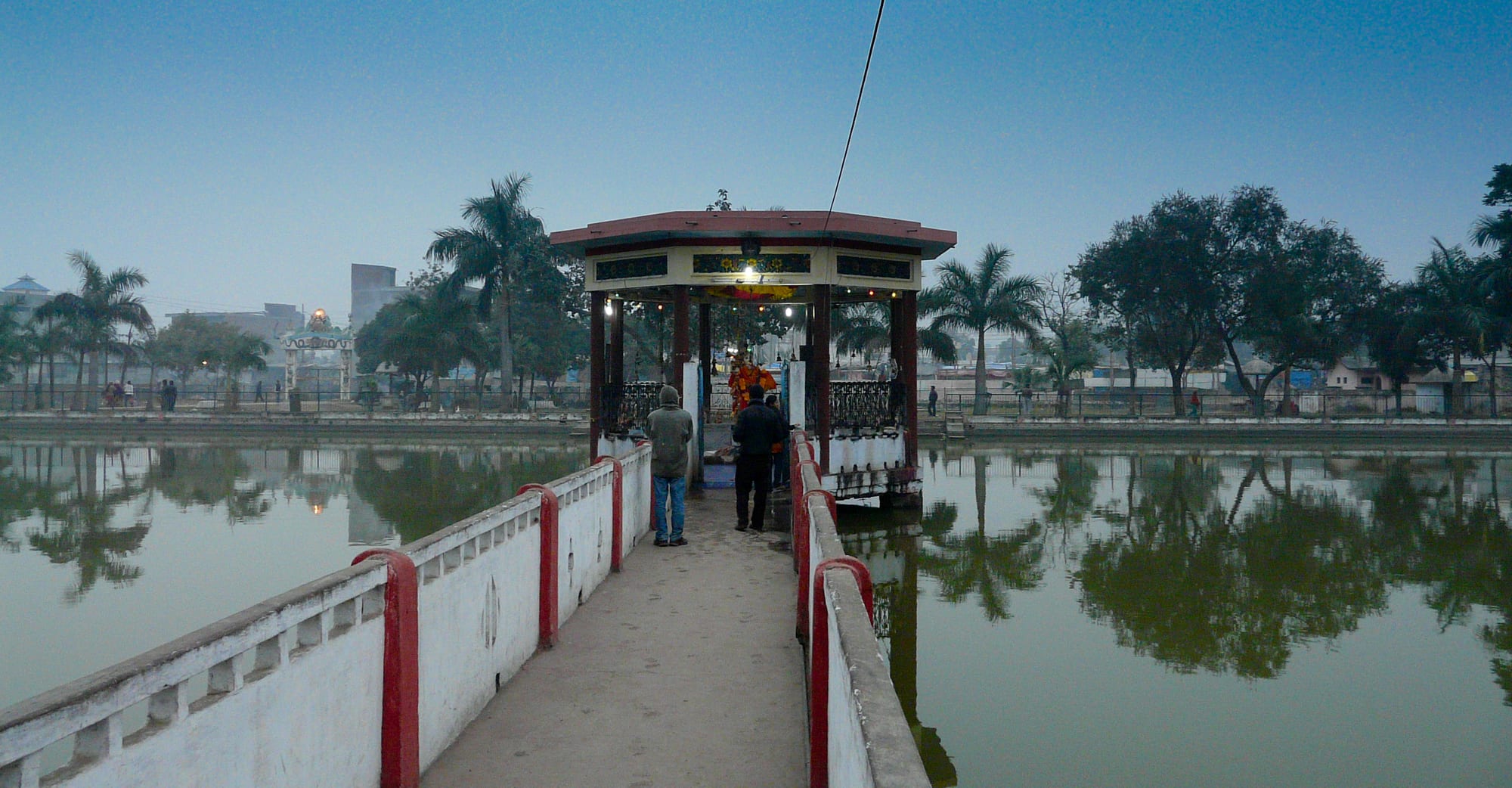
A statue of Shiva standing on a white causeway across a still green temple pond at dusk, with palms and low buildings behind

Lumbini, Bardia & the West, Nepal

Nepalgunj

The Mahadev statue on the Bageshwori temple pond in the centre of Nepalgunj. (Rabin Karki / Wikimedia Commons · CC BY 3.0)

One of the largest cities of western Nepal, on the flat Terai in Banke district and only a few kilometres from the Indian border. It grew as a trading town after the plains were returned to Nepal in 1860, it is a hot, busy market and transport centre with a mixed Hindu and Muslim population, and the airport from which small planes fly into the roadless districts of Karnali.

Neighbourhoods

  • Bageshwari and the temple pond
    • First-time visitors
    • Historic district
    • Temples

    The old heart of the city, around the Bageshwari temple and its large rectangular pond with a shrine reached by a causeway. Flower and offering stalls, sweet shops and small hotels stand close by, and the area fills in the early evening.

    Open in Maps
  • Dhamboji and the bazaar
    • Markets
    • Best for food
    • Local life

    The main commercial crossroads and the streets of cloth, jewellery, electronics and grain shops around it, thick with rickshaws and motorcycles. Much of the city's cheaper accommodation and its busiest eating places are here.

    Open in Maps
  • Surkhet Road and the airport side
    • Hotels
    • Close to public transport

    The wider road running north towards Kohalpur, with the newer hotels, offices and hospitals along it and Nepalgunj Airport a short drive out of town. It is the practical base for anyone catching a mountain flight.

    Open in Maps
  • The border strip
    • Onward travel
    • Markets

    The southern edge of the city running down to the crossing at Jamunaha and the Indian town of Rupaidiha, lined with freight yards, customs agents, cycle rickshaws and shops serving cross-border trade.

    Open in Maps

Things to do

Temples and the old city

  • Bageshwari Templelandmark

    One of the most important Hindu temples in Nepal, dedicated to the goddess Bageshwori in her Durga form; the compound also holds a rare shrine to a moustached Shiva, one of only two such temples in the country.

    Open in Maps
  • Bageshwari pondpark

    The walled tank beside the temple, crossed by a causeway to a small pavilion, used for evening walks and for ritual bathing at festivals.

    Open in Maps
  • The mosques of the old quarterlandmark

    More than a quarter of the city is Muslim, and mosques and madrasas stand among the shops in the older streets, with the call to prayer part of the daily sound of the centre.

    Open in Maps

Markets and the border

  • Dhamboji bazaarmarket

    The main shopping crossroads, where cloth, brassware, spices and household goods brought across the border are sold from crowded shopfronts.

    Open in Maps
  • Jamunaha–Rupaidiha border crossingtransit hub

    The open frontier a few kilometres south, one of the busiest crossings between Nepal and Uttar Pradesh, with freight lorries, rickshaws and a steady flow of people in both directions.

    Open in Maps
  • Nepalgunj Airporttransit hub

    The regional airport north of the city, the base for small aircraft and helicopters serving Simikot, Jumla, Dolpa and other mountain airstrips with no road link.

    Open in Maps

Countryside nearby

  • Banke National Parkpark

    Forest and grassland in the Siwalik hills east of the city, established in 2010 and managed with Bardiya National Park as a single tiger conservation unit, crossed by the East–West Highway.

    Open in Maps
  • Kohalpurneighborhood

    The highway junction town north of Nepalgunj where the road from India meets the East–West Highway, with a teaching hospital and the bus connections to the rest of the country.

    Open in Maps

Short trips

  • Bardiya National Parkpark

    The largest national park of the Terai, east along the highway, known for Bengal tigers, one-horned rhinoceros, wild elephants and the river dolphins of the Karnali.

    Open in Maps
  • Karnali Bridge at Chisapanilandmark

    A long single-tower cable-stayed bridge carrying the East–West Highway over the Karnali river, at the point where it leaves the hills onto the plain.

    Open in Maps

Seasonal events

  • DashainSeptember or October

    The longest Hindu festival of the year, when the Bageshwari temple draws large crowds and the bazaar is at its busiest for clothes and livestock.

  • TiharOctober or November

    The festival of lights, with lamps, marigolds and rangoli patterns at shop doors and singing groups moving through the neighbourhoods.

  • ChhathOctober or November

    The Terai festival honouring the sun, when families gather at ponds and riverbanks at sunset and again at sunrise to make offerings standing in the water.

  • Eidvaries with the lunar calendar

    The two Eids are major occasions in a city with a large Muslim community, marked by prayers, family visiting and sweets sold through the bazaar.

Eat and drink

Long-standing places and food districts in Nepalgunj. Hours, ratings and directions come from your maps app, always current.

Nepalgunj classics

  • Awadhi and Mughlai grillsrestaurant

    The city's Muslim kitchens cook in the style of neighbouring Uttar Pradesh — skewered and griddled kebabs, slow-cooked meat curries, biryani and thick flatbreads.

    Open in Maps
  • Daal bhaat and Terai thalirestaurant

    The standard Nepali meal of rice, lentils, a seasonal vegetable, greens and pickle, served in eateries around the bazaar and the bus park.

    Open in Maps

Markets and street food

  • Dhamboji street foodneighborhood

    Evening stalls around the main crossroads frying samosa, pakora and jalebi, mixing chatpate from puffed rice and chilli, and serving momo to a late crowd.

    Open in Maps
  • Sweet shops and lassi stallscafe

    Milk-based sweets such as barfi, rasbari and peda, thick sweetened curd, and lassi and sugarcane juice drunk against the heat.

    Open in Maps

Experience Nepalgunj

History

Nepalgunj is a comparatively young city with an old setting. The western Terai was ceded to British India after the Anglo-Nepalese War of 1814–16 and returned to Nepal in 1860, in the block of districts known as the Naya Muluk, the "new country", as payment for help during the Indian Rebellion of 1857. To hold and profit from the regained plains, a market town grew on the frontier in the following decades, drawing merchants and artisans, many of them Muslim families from Awadh and other parts of northern India.

The town prospered on cross-border trade in timber, grain and cloth, and on the traffic between India and the hill districts behind it. It also acquired a religious focus in the Bageshwari temple, a shrine known across western Nepal. Malaria kept the plains thinly settled until control programmes in the 1950s and 1960s, after which people came down from the hills in large numbers and the town's population and hinterland grew quickly.

The second half of the 20th century made Nepalgunj a regional capital in fact if not in name: the administrative centre of Banke district, the site of the airport that links Karnali's roadless districts to the rest of the country, and the market for a wide stretch of the mid and far west. It grew through the Maoist conflict of 1996–2006 as families moved in from insecure hill districts, and it has had episodes of communal and political unrest, including during the Madhesh movements that followed the 2015 constitution. Today it is a sub-metropolitan city in Lumbini Province and the largest urban centre in Banke district.

Culture & Customs

Nepalgunj is the most obviously plural city in western Nepal. Hindu and Muslim communities have lived side by side here since the town was founded, and the skyline of the old quarter mixes temple finials with minarets. Christian congregations, Tharu families from the surrounding countryside and hill migrants speaking Nepali all add to the mixture, and Awadhi, Hindi, Urdu and Nepali are heard in the same street.

The festival calendar reflects that. Dashain and Tihar fill the bazaar in autumn, Chhath brings crowds to ponds and riverbanks at dawn and dusk, Holi is thrown with Terai enthusiasm in spring, and the two Eids are public occasions with prayers, visiting and sweets. Weddings are large and loud, with brass bands and processions through the streets, and the film music, clothing and food of northern India are as familiar here as anything from Kathmandu.

Manners are those of the plains and lean conservative. Dress is covered, greetings are made with palms together or with a salaam depending on the household, and shoes are left at every threshold. The city is used to traders, aid workers and pilots rather than tourists, and foreign visitors attract friendly curiosity. Relations between communities are a live subject locally, and outsiders are wise to listen rather than opine.

Daily Life

About 140,000 people live in the sub-metropolitan city, one of the biggest urban centres of the western Terai. The streets are a constant flow of cycle rickshaws, auto-rickshaws, motorcycles and hand carts, and the working day is split by the heat: shops and offices open early, empty in the early afternoon, and fill again in the cooler evening, when the pond and the main crossroads become the places to be.

Trade drives the economy. Goods, produce, fuel and building materials move across the border at Rupaidiha, wholesalers here supply shops through the mid and far west, and agriculture in Banke district brings rice, sugarcane, mustard and vegetables to market. The airport supports a second economy of flights, freight and aid logistics into Karnali, and the city has hospitals, colleges, government offices and the regional bases of many non-governmental organisations. Many families also depend on work in India or the Gulf.

The everyday problems are heat, dust and water. Groundwater levels and drinking water quality are recurring concerns, air quality is poor in the dry months, and winter fog can shut the airport for days. Urban growth has been rapid and largely unplanned, drainage is overstretched in the monsoon, and employment for a young population is the issue that dominates local politics.

Food

Nepalgunj eats better than its size suggests, because two traditions meet here. One is the Muslim cooking brought from Awadh: kebabs grilled and griddled over charcoal, biryani layered with spiced meat and rice, korma and slow-cooked mutton, and breads from plain roti to rich, flaky paratha. The other is the Nepali daal bhaat served everywhere — rice, lentils, a seasonal vegetable, greens and a chilli chutney — with Tharu dishes from the surrounding villages, including river fish, snails and steamed rice-flour dumplings, appearing at homes and homestays.

Street food is a genuine pleasure and cheapest in the evening. Samosa and pakora come out of the pan all day, chatpate is mixed to order from puffed rice, potato, chilli and lemon, panipuri is sold from glass cases, and momo and chow mein brought by hill migrants have become standard. Sweet shops turn out barfi, peda, rasbari and jalebi, and thick curd is sold in clay pots.

Drinks answer the climate. Tea is boiled with milk and sugar and drunk all year; lassi, sugarcane juice pressed at the roadside, green coconut and cold sherbets carry the city through the hot months. Mangoes, lychees, guava and citrus from the Terai orchards arrive in season, and the local market for spices and ghee reflects both sides of the border.

Planning tools

Budget

Nepalgunj is cheap for food and lodging, and most visitors are here for a night between a flight and a bus. Hotel rooms with air conditioning cost noticeably more than fan rooms and are worth it from March to June. The significant expense is the mountain flight onward to Karnali, which is priced well above other domestic routes.

Daily Budget Midrange
USD 40–90 (air-conditioned hotel, restaurant meals, taxis, a private transfer to Bardiya)
Daily Budget Shoestring
USD 10–20 (fan room in a small hotel, daal bhaat and street food, rickshaws and local buses)

Keep cash for flights and permits arranged through agencies, and budget spare days in case mountain flights are delayed.

Best Time to Visit

October to February is the comfortable season, with warm days, cool evenings and the big autumn festivals, although thick morning fog in December and January regularly delays flights and buses. March onwards turns fierce, with the pre-monsoon weeks among the hottest in the country, and the monsoon from June to September is humid with heavy rain.

Suggested Number of Days

A day covers the temple, the bazaars and the border strip, which is what most travellers passing through have. Two or three days make sense for anyone using the city as a base for the national parks or waiting on a flight into the mountains.

First Visit
1 day
With Surroundings
2–3 days

Transportation

Cycle rickshaws, auto-rickshaws and electric tempos are the everyday way to move around, and fares are low and negotiated before setting off. Taxis can be hired for the airport or the border. Buses and jeeps leave from the bus park for Kohalpur, the East–West Highway, Bardiya, Surkhet and Kathmandu, and local services run to the border every few minutes.

Agree a rickshaw fare before getting in, and allow extra time in the fog season for the drive out to the airport.

Airport & Station Connections

Nepalgunj Airport, a short drive north of the centre, has daily flights from Kathmandu and is the hub for small aircraft to Simikot, Jumla, Dolpa and other mountain strips. By road the city lies about 16 kilometres south of the East–West Highway at Kohalpur, with long-distance buses from Kathmandu and Pokhara taking most of a day and night. The Indian border at Rupaidiha is a few kilometres away, with onward road and rail links in Uttar Pradesh.

Walkability

The centre is flat and compact, and the temple, the pond and the main bazaar are a short walk apart. Against that, the heat for much of the year makes midday walking unpleasant, pavements are broken or occupied by stalls, and traffic at the crossroads is dense and gives little room to pedestrians. Early morning and evening are the times people walk.

Safety

Nepalgunj is a generally safe city, with the usual risks of a busy border town: pickpocketing in crowds and around the bus park, road accidents in heavy rickshaw and motorcycle traffic, and touts at the crossing. The city has seen communal tension in the past, and political strikes or bandhs can close roads and shops at short notice. Heat and mosquito-borne illness are genuine hazards.

Drink treated water and avoid the midday sun from March to June, use repellent at dusk, watch bags at the bus park and the border, and ask locally before travelling during a strike. Check current official travel advice before travelling.

Climate

One of the hottest places in Nepal. The city sits on the plains with no relief from altitude, and the year runs from a foggy, mild winter through a scorching spring to a humid monsoon that brings almost all the rain.

Summer
extremely hot then humid — regularly above 40°C from April to June, among the highest temperatures anywhere in Nepal, followed by monsoon rain and high humidity
Winter
mild days and cold, foggy mornings — roughly 8–24°C, with dense fog that can ground flights

Local Customs

The city is religiously mixed, with a large Hindu majority, a Muslim quarter of the population and smaller Christian and other communities, and it is more conservative in dress and manner than Kathmandu. Modest clothing is expected, shoes come off at temple and mosque doors, and the inner shrine of the Bageshwari temple has its own restrictions. Alcohol is sold but is not part of public life in most quarters.

Dress with shoulders and knees covered, ask before photographing people, mosques or worshippers, use the right hand for giving and receiving, and be discreet with food and drink in public during Ramadan.

Common Payment Methods

The currency is the Nepalese rupee, and cash dominates. Banks and ATMs are plentiful along the main roads, hotels and larger shops may take cards or mobile payment, and rickshaws and stalls do not. Indian rupees change hands informally near the border, but large Indian notes are not accepted and formal exchange is done at banks and licensed counters.