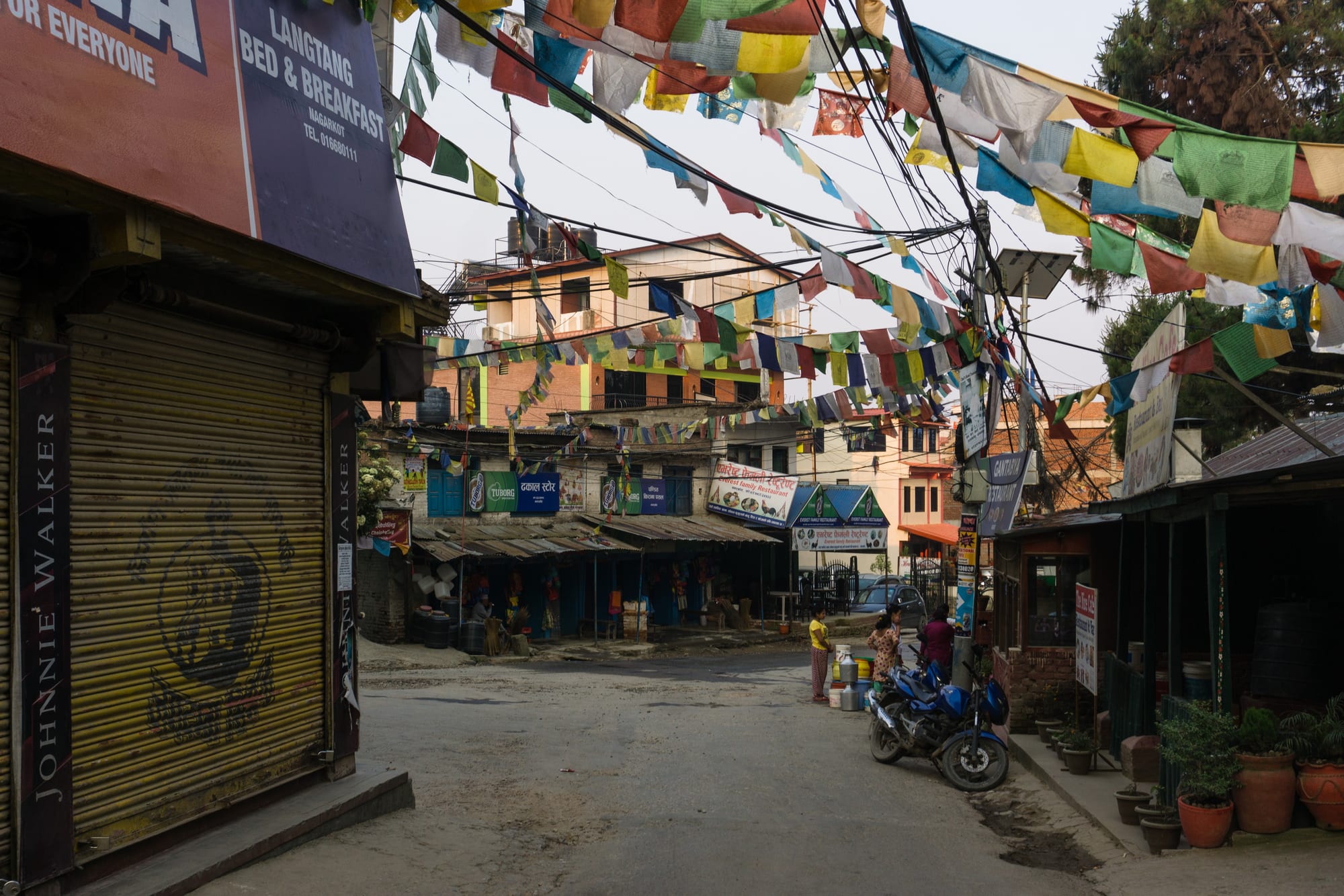
A quiet village street in Nagarkot with lines of coloured prayer flags strung overhead, small shopfronts and a parked motorbike

Kathmandu & Central Nepal, Nepal

Nagarkot

Prayer flags over the main street of Nagarkot, on the eastern rim of the Kathmandu Valley. (Alexey Komarov / Wikimedia Commons · CC BY-SA 4.0)

A ridge-top village on the eastern rim of the Kathmandu Valley, at about 2,200 metres and some 30 kilometres from the capital. Once a hill fort and later a royal summer retreat, it is now a line of hotels and guesthouses along the crest, visited above all for the sunrise view along the Himalayan range and for walks down through terraced farmland and pine forest.

Neighbourhoods

  • The bazaar and bus stand
    • First-time visitors
    • Local life
    • Close to transport

    The small crossroads settlement where the road from Bhaktapur arrives, with shops, tea stalls, a few restaurants and the bus stand. It is the only real street in the village and the point most walks start from.

    Open in Maps
  • The ridge and the view tower
    • Sunrise views
    • Hotels

    The crest running south from the bazaar towards the army area and the old view tower, lined with hotels and guesthouses whose terraces face north-east across the valley towards the mountains. Rooms here are quiet and the road is steep.

    Open in Maps
  • The lower slopes and farming hamlets
    • Quiet and residential
    • Walks

    Below the crest the hillside falls away in terraces of maize, millet and vegetables, with Tamang and Newar hamlets, pine woods and footpaths linking them. A few homestays and small lodges sit among the fields.

    Open in Maps

Things to do

Views and walks

  • The Nagarkot ridge viewpointviewpoint

    The high point at the southern end of the village, with a tower giving an open panorama along the Himalaya in clear weather and down over the terraced valley.

    Open in Maps
  • Shivapuri Nagarjun National Parkpark

    The forested hills along the northern rim of the valley, visible from the ridge and walked from the Kathmandu side, with trails through oak and rhododendron.

    Open in Maps

Short trips from the village

  • Changu Narayanlandmark

    A hilltop Vishnu temple reached by a long downhill walk from the ridge, one of the oldest in the valley, with Licchavi stone sculpture and a 5th-century inscription.

    Open in Maps
  • Bhaktapurneighborhood

    The old Malla city below the ridge, about an hour away by road, with its Durbar Square, the Nyatapola temple and potters' yards.

    Open in Maps
  • Dhulikhelneighborhood

    A Newar town on the Araniko Highway south-east of the ridge, itself a mountain viewpoint, with an old core of brick houses and walks to nearby hills.

    Open in Maps
  • Namobuddhalandmark

    A Buddhist pilgrimage site on a hill beyond Dhulikhel, with a large monastery and a stupa marking a legend of the Buddha and a starving tigress.

    Open in Maps
  • Sankhuneighborhood

    An old Newar trading town on the valley's north-eastern side, below the temple of Bajrayogini and on the former route towards Tibet.

    Open in Maps

Seasonal events

  • DashainSeptember or October

    The long autumn festival, when village families gather, swings are put up on the hillsides and the hotels fill with visitors from Kathmandu.

  • TiharOctober or November

    The festival of lights, with oil lamps along the village houses and singing groups going from door to door.

  • Nepali New Yearmid-April

    The turn of the Bikram Sambat year in April brings day-trippers up from the valley for picnics on the ridge, at the start of the warm season.

Eat and drink

Long-standing places and food districts in Nagarkot. Hours, ratings and directions come from your maps app, always current.

Where to eat

  • Hotel and guesthouse kitchensrestaurant

    Most eating is done where people sleep — daal bhaat, momos, thukpa, curries and simple Western dishes, often served on terraces facing the mountains.

    Open in Maps
  • The bazaar tea shopscafe

    Small shops at the crossroads selling milk tea, instant noodles, samosas and biscuits to bus passengers, drivers and villagers through the day.

    Open in Maps
  • Daal bhaatrestaurant

    Rice with lentil soup, vegetable curry, greens and pickle, the standard hill meal and the most reliable thing to order in the village.

    Open in Maps

Experience Nagarkot

History

The ridge owes its name and its first purpose to defence: Nagarkot, the fort of the city, was one of the strongpoints watching the eastern approaches to the Kathmandu Valley, guarding the routes that came up from the Banepa side and on towards Tibet. Hilltops around the valley rim were fortified under the Malla kings, and control of them mattered in 1768–69, when Prithvi Narayan Shah of Gorkha closed in on the three royal cities and took them one after another. The army still keeps a presence on the ridge, and part of the crest is closed military ground.

For most of its history the population of the slopes was rural, Tamang and Newar farmers working terraces of maize, millet, wheat and vegetables and cutting fodder in the pine and oak woods. The royal family used the cool ridge as a summer retreat from the heat and dust of the valley below, and a road was pushed up to serve it, which is the reason a farming ridge acquired a hotel trade at all.

Foreign visitors began to arrive as Nepal opened to independent travellers and word spread of a viewpoint within easy reach of Kathmandu from which the Himalaya could be seen at dawn. Guesthouses multiplied along the crest, then hotels and resorts, and the village became a standard overnight trip from the capital and an international hill station. The 2015 earthquake damaged buildings here as across the valley rim, and the tourism collapse that followed the pandemic hit a village largely dependent on visitors; the hotels have since refilled, largely with Nepali weekend travellers as well as foreign ones.

Culture & Customs

Two kinds of life run side by side on the ridge. The hotel strip belongs to the tourist economy, staffed in part by people from elsewhere in Nepal, while the hamlets below the crest keep the rhythms of hill farming: fields worked by hand and with oxen, fodder carried in doko baskets, and households that measure the year by planting and harvest rather than by season fares.

The surrounding population is mixed. Tamang communities, Buddhist and Tibeto-Burman in language, keep gompas, prayer flags and chortens on the hillsides, and the strings of flags over the bazaar are a reminder of them. Newar families from the valley towns hold land and shops here, and Chhetri and Brahmin households from the hills farm alongside them, so Hindu and Buddhist festivals are both marked and often by the same families. Dashain and Tihar empty the village of its workers, who return to their own districts.

Visitors come for a single event — the sunrise — and the village's manners have arranged themselves around it: early breakfasts, terraces set facing north-east, and a quiet, early night. Nepali visitors come in large groups at weekends and holidays, especially in the autumn and at the April new year, which gives the ridge a picnic atmosphere quite unlike its reputation among foreign travellers for silence. Away from the hotels people are reserved and courteous, and photography of homes and family work is best asked about first.

Daily Life

A few thousand people live on the ridge and the slopes below it, in a settlement that belongs administratively to Changunarayan municipality in Bhaktapur district. The economy is simple: hotels, guesthouses, small restaurants and shops along the crest, farming below it, and wages sent home by family members working in Kathmandu or abroad. Many households do both, running a homestay in the season and the fields the rest of the year.

The working day is shaped by the visitors. Kitchen and reception staff are up well before dawn to open terraces and make tea, the buses and jeeps bring the day's arrivals in the afternoon, and the bazaar quietens by early evening. Farm households start earlier still, cutting fodder and milking before the children walk to school. Water is carried or pumped up the ridge and is a constant concern, as is road maintenance after monsoon landslides.

The village's fortunes rise and fall sharply with the season and with events far away: a dust-free autumn brings full rooms, a wet monsoon or a national crisis empties them. Building has spread along the ridge in recent years, and residents debate how much of the view can be built on before there is little left to come for. Mobile coverage is good, electricity reliable most of the time, and Bhaktapur, an hour down the hill, supplies schools, hospitals and markets.

Food

There is no distinct Nagarkot cuisine; what the ridge offers is hill food with a view. The staple is daal bhaat — rice, lentil soup, a seasonal vegetable curry, greens and pickle, with meat on festival days — eaten twice daily in village households and served in every guesthouse. Local vegetables come from the terraces below: potatoes, radish, mustard greens, beans and maize, with millet in the higher fields.

Momos, the steamed or fried dumplings eaten all over Nepal, are on every menu, as is thukpa, the Tibetan noodle soup that suits a cold morning on the crest, and chow mein. Tamang households make dhindo, a stiff porridge of millet or maize flour eaten with soup and pickle, and gundruk, fermented dried leafy greens, gives the hills their characteristic sour soup. Buffalo and goat appear in curries, and dried meat, sukuti, is a bar snack as well as a way of keeping meat through the season.

Tea is the constant: strong milk tea with sugar and sometimes ginger or cardamom, poured from morning onwards in the bazaar shops. Breakfasts on hotel terraces run to eggs, toast and Tibetan bread with honey, and bottled beer and raksi, the clear home-distilled spirit of the hills, are drunk in the evenings. Because supplies come up the hill by road, menus are shorter and prices higher than in Bhaktapur below.

Planning tools

Budget

Nagarkot is cheap to reach and the accommodation covers a wide range, from plain guesthouses in the bazaar to hotels and resorts on the crest charging valley prices for a mountain view. Food is mostly eaten at the hotel, which pushes daily costs above those of a town with competing restaurants. There is no entry fee to the village.

Daily Budget Midrange
USD 45–100 (hotel room facing the mountains, meals at the hotel, a taxi from Kathmandu)
Daily Budget Shoestring
USD 15–25 (basic guesthouse, daal bhaat, local bus up from Bhaktapur)

A north or east-facing room is what visitors are paying for here, and rooms fill on clear autumn weekends.

Best Time to Visit

October to early December is the clearest season, when the monsoon dust has been washed out of the air and the mountains are visible on most mornings. February to April is warm with spring flowers but hazier. Winter is cold and crisp with good visibility and frosty mornings. The monsoon from June to September usually closes the view in cloud, though the hillside is green and the crowds are thin.

Suggested Number of Days

One night is enough for most visitors, who come up in the afternoon and leave after the morning view. Two or three days suit walkers linking the ridge with the valley rim towns, and give a second chance at a clear morning if cloud spoils the first.

First Visit
1 night
With Surroundings
2–3 days

Transportation

Local buses and shared jeeps climb from Bhaktapur to the Nagarkot bazaar, and taxis and ride-hailing cars come directly from Kathmandu. The village itself is one road along the ridge, walked end to end in half an hour, and hotels are strung along it. Footpaths lead downhill to Changu Narayan, Sankhu and the villages below.

Roads on the ridge are steep and narrow, and can be slippery in the monsoon or after frost.

Airport & Station Connections

The village is about 30 kilometres east of central Kathmandu by road, usually 1.5 to 2.5 hours by taxi depending on traffic in the valley, and about an hour up from Bhaktapur. Most visitors come as an overnight trip from the capital; walkers arrive on foot from Changu Narayan or Sankhu, and Dhulikhel is linked by road to the south-east.

Walkability

Everything in the village is within walking distance along the crest, though the road climbs steadily and luggage is easier in a vehicle. The surrounding hillside is laced with paths through terraces and pine forest, and the downhill walks to Changu Narayan or Sankhu take a few hours. There is little traffic and no pavement.

Safety

Nagarkot is a quiet village with very little crime. The practical risks are the mountain road, cold at night for anyone arriving without warm clothes, and getting lost on unmarked footpaths in mist. Parts of the ridge are used by the army and are closed to visitors. Landslides can block the road in heavy monsoon rain.

Carry a torch and a warm layer for early mornings, keep to marked paths in cloud, and respect signs at military ground. Check current official travel advice before travelling.

Climate

At about 2,200 metres the ridge is several degrees cooler than the valley floor and often windy. Mornings are the clearest part of the day, and cloud builds from the valley in the afternoon through much of the year.

Summer
mild and wet, roughly 15–25°C, with frequent cloud and monsoon rain from June to September
Winter
cold, with frosty mornings and bright days, roughly 0–15°C, and occasional snow on the ridge

Local Customs

The surrounding villages are Tamang, Newar and Chhetri farming communities, and life outside the hotels is conservative and rural. Shoes are removed indoors and at shrines, prayer flags and chortens are passed on the left by Buddhist custom, and modest dress is expected away from hotel grounds. Greetings are made with palms together.

Ask before photographing people or their houses, and take rubbish back down to the valley, since collection on the ridge is limited.

Common Payment Methods

The currency is the Nepalese rupee, and cash is used for almost everything, including buses, tea shops and small guesthouses. Larger hotels may take cards, but connections can be unreliable on the ridge. There is little banking in the village, so money is best drawn in Bhaktapur or Kathmandu before coming up.