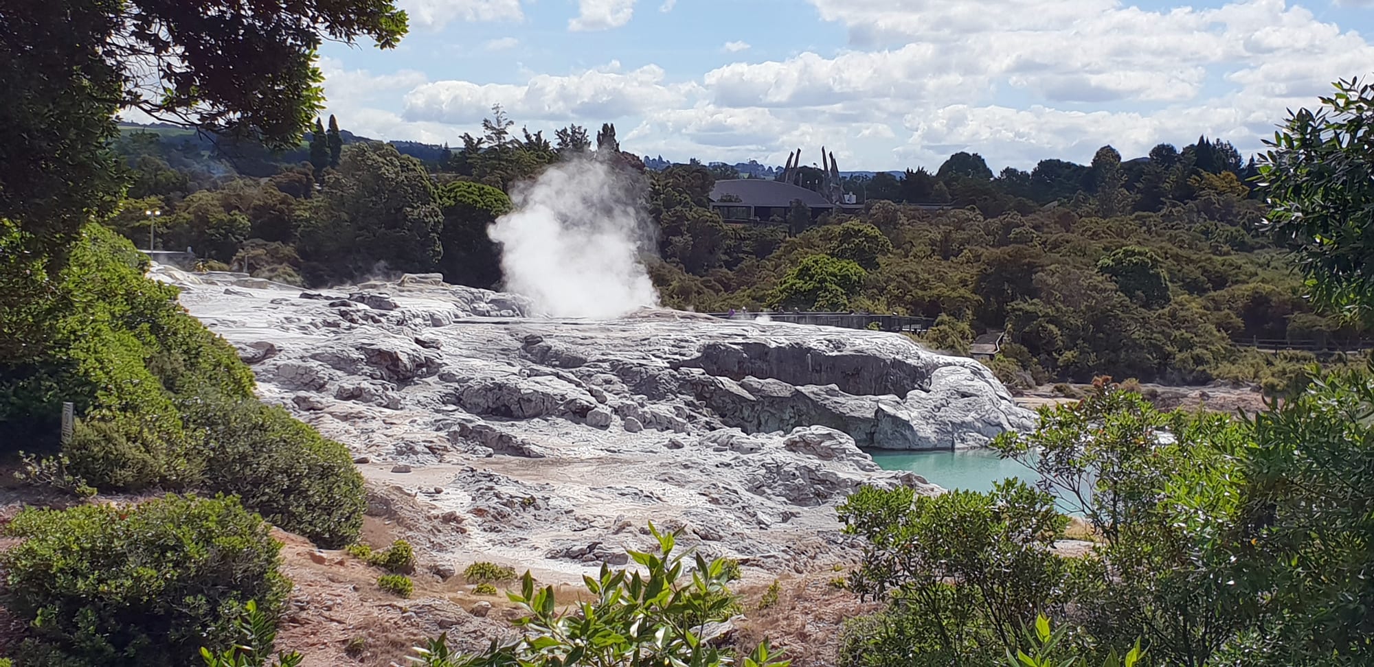
Steam rising from a geyser on pale silica terraces beside a blue-green pool, with green bush and rooftops behind

Rotorua, Waikato & the Bay of Plenty, New Zealand

Rotorua

Steam from the Pōhutu geyser above the silica terraces at Whakarewarewa in Rotorua. (Anagoria / Wikimedia Commons · CC BY-SA 3.0)

A city on the southern shore of Lake Rotorua, on the North Island's volcanic plateau, where geysers, boiling mud and hot springs break through the ground inside the built-up area. Te Arawa have hosted visitors here since the nineteenth century, and the city combines a spa-town heritage with Māori cultural performance, forest mountain biking and lakes.

Neighbourhoods

  • City centre
    • First-time visitors
    • Close to public transport
    • Best for food

    A flat grid between the lakefront and Kuirau Park, with the shopping and restaurant streets of the centre, the information centre, most of the motels and hotels within walking distance, and steam drifting from drains and gardens after rain.

    Open in Maps
  • Government Gardens and the lakefront
    • Historic district
    • Parks and gardens
    • Walks and viewpoints

    The spa quarter laid out by the government on the eastern edge of the centre, with the half-timbered Bath House, croquet and bowling lawns, rose beds, thermal pools and a lakeside path leading round to the jetties and playgrounds of the rebuilt lakefront.

    Open in Maps
  • Ohinemutu
    • Historic district
    • Māori culture
    • Quiet and residential

    A Te Arawa village on the lake shore, and the original settlement on this site, where houses stand among steaming ground beside the carved Tamatekapua meeting house and St Faith's Anglican church.

    Open in Maps
  • Whakarewarewa and Fenton Street
    • Geothermal sights
    • Close to attractions
    • Motels

    The southern approach to the city, where Fenton Street's long line of motels runs out towards the geothermal valley, the arts institute and the forest, with the racecourse and sports grounds in between.

    Open in Maps
  • Ngongotahā
    • Quiet and residential
    • Family-friendly
    • Lakeside

    A suburb about ten kilometres round the lake on its western side, below Mount Ngongotahā, with trout streams, springs, a small shopping street and farm attractions nearby.

    Open in Maps
  • The Blue Lake and Tarawera road
    • Beaches
    • Swimming
    • Quiet and residential

    South-east of the city the road climbs through the Redwoods and past Lake Tikitapu, the Blue Lake, whose sandy beach and swimming are popular in summer, to holiday houses and boat ramps at Lake Tarawera.

    Open in Maps

Things to do

Geothermal parks and springs

  • Te Puiaattraction

    The geothermal reserve at Whakarewarewa holding Pōhutu, the largest geyser in the southern hemisphere, which erupts many times a day, along with mud pools and the national carving and weaving school.

    Open in Maps
  • Whakarewarewa Living Māori Villageneighborhood

    A village where Tūhourangi and Ngāti Wāhiao families still live among the steam vents and use the boiling pools for cooking and bathing, shown on guided walks.

    Open in Maps
  • Kuirau Parkpark

    A free public park beside the city centre with steaming craters, a mud pool, fenced boiling ground and hot foot baths.

    Open in Maps
  • Polynesian Spaattraction

    Long-established public bathing pools on the lakefront edge of the Government Gardens, fed by mineral springs, among them the acidic Priest's Bath, bathed in since the 1870s.

    Open in Maps
  • Hell's Gateattraction

    A geothermal reserve at Tikitere, north-east of the city, known for violently boiling pools, a sulphur-rich mud bath and the Kakahi Falls, the largest hot waterfall in the southern hemisphere.

    Open in Maps

Te Arawa culture

  • New Zealand Māori Arts and Crafts Instituteattraction

    The national school of Māori carving, weaving and stone and bone work, founded in 1963 at Whakarewarewa, where students can be watched at work.

    Open in Maps
  • St Faith's Anglican Churchlandmark

    The lakeside Anglican church at Ohinemutu, where Frederick Bennett, born in the village and later a bishop, is buried beneath the sanctuary.

    Open in Maps
  • Tamatekapua meeting houselandmark

    The carved wharenui at Te Papaiouru Marae in Ohinemutu, named for Tama-te-kapua, who captained the Arawa canoe.

    Open in Maps

Lakes, forest and parks

  • Government Gardenspark

    Formal gardens of roses, lawns and thermal pools around the 1908 Bath House, a half-timbered building put up by the government to draw spa visitors.

    Open in Maps
  • Lake Rotoruaattraction

    The large caldera lake the city sits beside, with a rebuilt lakefront, boat and float-plane trips and the island of Mokoia, a bird sanctuary, in its middle.

    Open in Maps
  • Whakarewarewa Forestpark

    The Redwoods, a forest of Californian redwoods planted from 1901 on the city's edge, with walking tracks, a treetop walkway and one of the country's best mountain-bike networks.

    Open in Maps
  • Lake Tikitapubeach

    The Blue Lake, a small round crater lake with a sandy swimming beach, a walking track around it and water sports in summer.

    Open in Maps
  • Lake Taraweraattraction

    A large lake beneath Mount Tarawera, reached by road 18 kilometres east, used for trout fishing and boat trips to hot springs on its far shore.

    Open in Maps
  • Mount Ngongotahāviewpoint

    The 757-metre rhyolite dome above the lake's western suburbs, with a walking track to the summit and a gondola to a viewing platform, luge tracks and a restaurant.

    Open in Maps

Outdoor activities

  • Agrodomeattraction

    A farm park north of the city, set up in 1971 by the champion shearer Godfrey Bowen and a local farmer, with sheep-shearing and sheepdog shows and farm tours.

    Open in Maps
  • Okere Fallsattraction

    A set of rapids and waterfalls on the Kaituna River north-east of the city, with a short bush track past viewing platforms and Tutea's Caves, and commercial rafting through the gorge.

    Open in Maps
  • Rotorua mountain-bike trailstrail

    A large network of graded trails in the Whakarewarewa Forest, from gentle loops to steep descents, which have made the city a mountain-biking destination.

    Open in Maps

Short trips from the city

  • Wai-O-Tapuattraction

    A geothermal park about 27 kilometres south with the orange-rimmed Champagne Pool, bright green and yellow crater lakes and the Lady Knox geyser.

    Open in Maps
  • Waimangu Volcanic Rift Valleyattraction

    A valley created by the 1886 Tarawera eruption, walked downhill past the steaming Frying Pan Lake and the pale blue Inferno Crater to Lake Rotomahana.

    Open in Maps
  • Mount Taraweraviewpoint

    The mountain that split open in the eruption of June 1886, killing about 120 people and burying nearby villages, now visited by guided four-wheel-drive and helicopter tours to its craters.

    Open in Maps
  • Buried Village of Te Wairoamuseum

    The excavated remains of the village destroyed by the 1886 eruption, with a museum, dug-out whare and a bush walk to a waterfall.

    Open in Maps

Seasonal events

  • Crankworx Rotoruaautumn

    A week of mountain-bike competition in the Whakarewarewa Forest, part of an international freeride series.

  • Rotorua Marathonautumn

    A long-established road marathon run around Lake Rotorua.

  • Tarawera UltramarathonFebruary

    A trail running event over lake and forest tracks east of the city, drawing runners from many countries.

  • MatarikiJune or July

    The Māori new year, marked with dawn ceremonies, kapa haka, food and light events in a city where Te Arawa lead the programme.

Eat and drink

Long-standing places and food districts in Rotorua. Hours, ratings and directions come from your maps app, always current.

Rotorua classics

  • Hāngī and concert eveningsrestaurant

    Several Te Arawa operators serve a hāngī — meat and vegetables steamed in an earth oven or in geothermal steam — with kapa haka performance, the city's best-known meal.

    Open in Maps
  • Central restaurant stripneighborhood

    Most of the city's restaurants, bars and breweries stand within a few blocks of the centre, the main place people eat out.

    Open in Maps
  • Steambox and corn cookersmarket

    At Whakarewarewa, sweetcorn and kūmara are cooked in boiling pools and steam boxes and sold at the village, a use of the ground that predates the tourist trade.

    Open in Maps

Cafés and local produce

  • Lakeside caféscafe

    Cafés along the rebuilt lakefront and in the Government Gardens serve brunch and coffee with views over the lake and the steam rising from its shore.

    Open in Maps
  • Trout and lake fishrestaurant

    The lakes hold rainbow trout, and restaurants will often cook an angler's own catch, while menus feature local lamb, beef and vegetables.

    Open in Maps

Experience Rotorua

History

Te Arawa trace their presence here to the canoe of that name, captained by Tamatekapua, which made landfall at Maketu on the Bay of Plenty coast; his descendant Īhenga is said to have discovered the lake and named it Te Rotorua-nui-a-Kahumatamomoe. Hapū settled the shore and the islands, and Ohinemutu grew as a village where the boiling pools were used for cooking, washing and heating. The local right to host and guide visitors, held by particular hapū, is old and still contested and respected today.

Tourism began in the 1870s, when parties travelled from Auckland to see the Pink and White Terraces on Lake Rotomahana, guided by Tūhourangi from Te Wairoa. Mount Tarawera erupted on 10 June 1886, destroying the terraces, burying Te Wairoa and other villages and killing about 120 people. Survivors moved to Whakarewarewa, which became the new centre of guiding, and figures such as Guide Sophia and Mākereti Papakura became internationally known.

The government then built Rotorua as a spa town under its own Department of Tourist and Health Resorts, laying out the Government Gardens, planting the avenues and opening the elaborate Bath House in 1908 to offer mineral cures. The town grew on land leased from Ngāti Whakaue to the government, and did not become a borough with its own council until 1922. Forestry arrived with the planting of the surrounding pine and redwood forests from the early twentieth century, and forestry is still one of the district's largest industries. Mass tourism followed the car and the aeroplane, and since the 1990s mountain biking, adventure activities and Māori cultural tourism have joined the geysers as the reasons people come.

Culture & Customs

No New Zealand city puts Māori culture as far forward as Rotorua. Te Arawa hapū own and run many of the city's attractions, kapa haka is performed professionally for visitors year-round, and the carving and weaving school at Whakarewarewa trains students from iwi across the country in traditional forms. Pōwhiri, hongi and waiata are part of ordinary commercial life here in a way visitors elsewhere may only glimpse, and te reo Māori is widely spoken.

The city is equally shaped by its spa inheritance. The Edwardian Bath House, the croquet lawn, the Blue Baths of 1933 and the gardens belong to a period when Rotorua was promoted as a health resort on an imperial circuit, and public bathing in mineral water continues at pools around the lakefront. The smell of hydrogen sulphide, which residents stop noticing, is part of local identity and the source of a great many jokes.

Outdoors, it is a sports town. The Redwoods trail network has made it a mountain-biking capital, with international competition each year; trout fishing on the lakes and streams is a serious pursuit, as is rafting the Kaituna rapids. Rugby, league and touch are followed closely, and the marathon around the lake is a long-standing annual fixture. Forestry and tourism workers, students at the local polytechnic and a large seasonal population give the small city a mixed, unpretentious feel.

Daily Life

About 58,500 people live in Rotorua, the country's thirteenth largest urban area, and more again in the wider lakes district. At the 2023 census 46 per cent of residents identified as Māori, one of the highest proportions of any New Zealand city, and the population also includes long-established Indian, Chinese and Pacific communities and seasonal workers in forestry and tourism. Housing spreads around the lake's southern and western shores, from the older streets near Ohinemutu and Whakarewarewa to the suburbs strung round the lake at Ngongotahā and out to the east.

Tourism and forestry are the twin pillars of the economy: hotels, attractions, guiding and hospitality on one side, and on the other the pine plantations, sawmills, wood processing and the research institutes that grew up with them. Geothermal energy heats homes, motels and public buildings through bores, which is cheap but tightly regulated: heavy drawing-off weakened the geysers, and in 1987–88 more than a hundred bores within 1.5 kilometres of Pōhutu were cemented shut, after which the geyser became more active again.

The day starts early and the centre empties in the evening except along the main restaurant strip. Weekends go to the lakes, the forest, fishing, sport and family gatherings, and the marae remains the focus of community life for many. Current local issues include housing shortages and the long-term use of motels for emergency accommodation, the water quality of the district's lakes, and a reliance on visitor numbers that swings with the seasons.

Food

The hāngī is the city's signature meal, and Rotorua's version is distinctive: as well as the earth oven, food is cooked in the natural steam of the thermal ground, so pork, chicken, lamb, kūmara, potato, pumpkin and stuffing come out faintly mineral-scented and very soft. It is usually served with rēwena, a slightly sour Māori bread raised with a fermented potato starter, and followed by steamed pudding. At Whakarewarewa, families still boil sweetcorn and kūmara in the pools and sell them at the gate, and eggs are cooked the same way.

Freshwater food matters more here than on the coast. Rainbow trout fill the lakes and rivers, and restaurants will prepare fish that anglers bring in themselves. Kōura, the small freshwater crayfish, was among the traditional Māori foods gathered from these lakes, which also hold eels, and the geothermal ground gave Te Arawa a way of cooking that needed no fire at all.

The surrounding farmland and orchards supply lamb, beef, milk, honey, avocados, berries and — from the Bay of Plenty over the hill — kiwifruit. In the city itself the eating is casual and international: the restaurants of the centre run from Japanese, Indian, Thai and Italian kitchens to steak houses, pizza places and craft breweries. Coffee is taken as seriously as anywhere in the country.

Planning tools

Budget

Rotorua has plenty of competitively priced motels and holiday parks, many with their own mineral pools, and beds cost less than in Auckland or Queenstown outside the school holidays. The expense here is entry charges: geothermal parks, cultural evenings, the treetop walk, the gondola and adventure activities each carry a substantial fee, and they add up fast.

Daily Budget Midrange
USD 150–270 (motel with a private hot pool, restaurant meals, a hire car, one or two paid attractions)
Daily Budget Shoestring
USD 50–85 (hostel bed or holiday park site, supermarket food, Kuirau Park, the Redwoods tracks and the lakefront)

Choosing one geothermal park and one cultural evening rather than all of them keeps costs down, and many motels include a private thermal pool in the room rate.

Best Time to Visit

The geothermal sights work all year and are at their most dramatic in cold weather, when the steam is thickest. December to March is warmest and best for the lakes, biking and walking, though the Christmas holidays are busy. Winter is quiet, frosty at night and the cheapest time to visit.

Suggested Number of Days

Two days cover the city and one geothermal area. Three or four allow the lakes, the forest and the volcanic country to the south as well. Mountain bikers and anglers routinely stay longer, and rain makes little difference to the thermal parks.

First Visit
2 days
With Surroundings
3–4 days

Transportation

A car is the easiest way to get around, since the geothermal parks, lakes and forest are spread over 30 kilometres. Local buses run from the city centre to the suburbs and to Whakarewarewa and Ngongotahā on weekday timetables, shuttles serve the main attractions and the airport, and the centre, the Redwoods and the lakefront are linked by cycleways and bike hire.

The forest trails have shuttle services for downhill riders, and bikes can be hired at the forest entrance rather than carried from a car.

Airport & Station Connections

Rotorua is about 230 kilometres south-east of Auckland, roughly three hours by car, and about an hour from Tauranga and an hour and a quarter from Taupō. Its airport, six kilometres north-east of the centre, has flights to Auckland, Wellington and Christchurch. Long-distance coaches link the city with Auckland, Hamilton, Taupō and the Bay of Plenty, and many visitors arrive on day coaches from cruise ships berthed at Tauranga.

Walkability

The centre is flat, compact and easy on foot, and a walk of twenty minutes or so joins the shops, the Government Gardens, Kuirau Park and the lakefront. Whakarewarewa is about three kilometres south of the centre and the Redwoods a similar distance, both reachable on foot or by bike but more often driven; everything else needs wheels.

Safety

A safe city for visitors, with occasional car break-ins at trailheads and lake car parks and some social problems visible in the centre. The distinctive risks are geothermal: unstable crust and boiling water beside paths, ground that can collapse, and hydrogen sulphide gas that collects in hollows and enclosed spaces. The lakes are cold and deep, and Mount Tarawera and the surrounding volcanic field are monitored for activity.

Stay on marked paths in every thermal area, keep children close and dogs on leads, do not enter fenced ground, and ventilate rooms where a sulphur smell is strong. Check current official travel advice before travelling.

Climate

A mild temperate climate on the volcanic plateau, wetter and cooler than the Bay of Plenty coast. Summer runs from December to February and winter from June to August, when frosty nights are common and the steam over the city is at its thickest. Rain falls throughout the year.

Summer
warm days, usually 22–25°C, with cool evenings and occasional thunderstorms
Winter
cool and damp, 11–14°C by day, with frequent frosts at night

Local Customs

Rotorua is a centre of Māori life, and visitors meet tikanga directly: a pōwhiri welcome before a concert or marae visit, a hongi, and waiata sung in reply. Guides explain what to do, and following their lead is expected. Shoes are removed before entering a meeting house and food and drink stay outside it. Tipping is not expected anywhere in the city.

Permission should be asked before photographing people, performances or marae, and the geothermal features of the living village treated as somebody's kitchen and bathroom rather than scenery. The drinking age is 18.

Common Payment Methods

The currency is the New Zealand dollar. Cards and contactless payment are taken almost everywhere, including at attractions and on buses, and a card surcharge is sometimes added. ATMs are common in the centre; a little cash is useful at markets and smaller stalls.