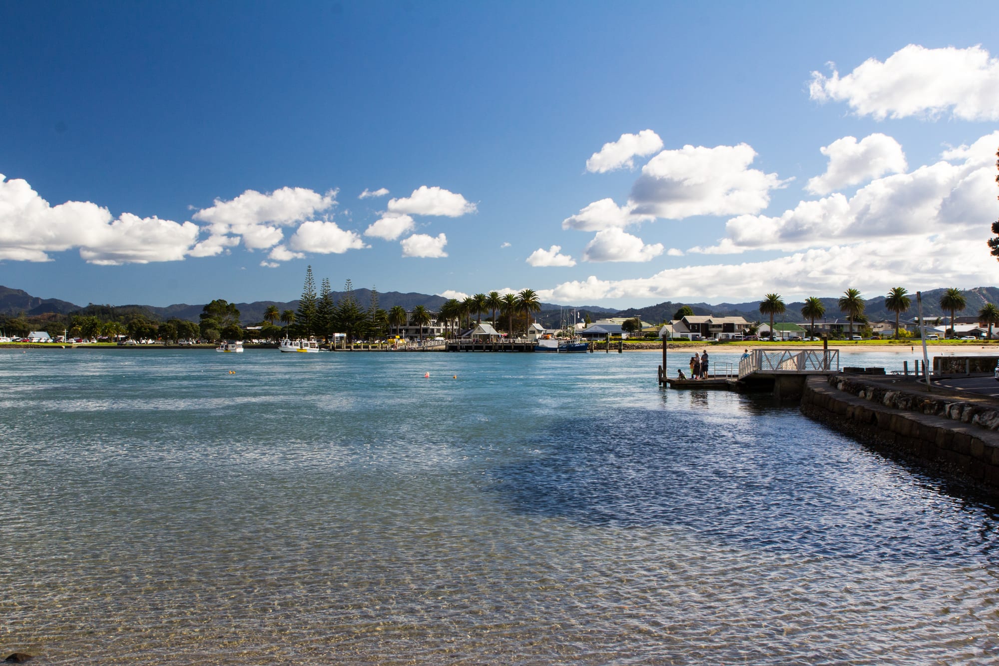
Clear shallow water at a harbour mouth, with a low town of houses, boats and palms along the far shore under hills

Rotorua, Waikato & the Bay of Plenty, New Zealand

Whitianga

Whitianga across the mouth of its harbour, seen from Ferry Landing on the eastern side. (Oren Rozen / Wikimedia Commons · CC BY-SA 3.0)

The main town on Mercury Bay, on the east coast of the Coromandel Peninsula, set at the mouth of a sheltered harbour. Built on kauri timber, gum digging and fishing, it now lives on boats, holiday homes and visitors, and serves as the base for Cathedral Cove, Hot Water Beach and the peninsula's eastern bays.

Neighbourhoods

  • Town centre and Buffalo Beach
    • First-time visitors
    • Best for food
    • Beaches

    The main street and the streets around it hold the shops, cafés and bars, a short walk from the wharf where the ferry and charter boats leave. Buffalo Beach runs north from the harbour mouth along the esplanade, backed by motels and holiday flats.

    Open in Maps
  • The canal district and the northern beaches
    • Boating
    • Quiet and residential
    • Holiday houses

    A canal development on the southern edge of town, built out from the marina approved in 1992, where houses have moorings at the back door, alongside older suburbs stretching north along the bay towards Wharekaho. Mostly residential and holiday homes, with shops a short drive away.

    Open in Maps
  • Ferry Landing and Flaxmill Bay
    • Quiet and residential
    • Views
    • Walks

    Across the harbour mouth, reached in a few minutes by passenger ferry or by a long road detour. A small settlement of houses and holiday accommodation around a historic stone wharf, with sheltered swimming bays and the track up to Shakespeare Cliff.

    Open in Maps
  • Cooks Beach
    • Beaches
    • Families
    • Quiet and residential

    A long sandy beach and low-rise settlement on the far side of the harbour, where James Cook's party landed in 1769. Largely holiday houses with a small shopping centre, popular with families for its calm, shallow water.

    Open in Maps
  • Hahei
    • Beaches
    • Snorkelling
    • Close to Cathedral Cove

    A small beach village about half an hour south-east by road, the land access point for Cathedral Cove and the marine reserve. A white-sand beach, a campground and a handful of eating places; very quiet out of season and crowded in January.

    Open in Maps

Things to do

Beaches and the coast

  • Buffalo Beachbeach

    The town's own beach, a five-kilometre crescent of sand on Mercury Bay named after HMS Buffalo, a Royal Navy ship wrecked in the bay in 1840, with a walkway along the esplanade.

    Open in Maps
  • Cathedral Covebeach

    A beach with a huge natural rock archway, beside the Te Whanganui-A-Hei marine reserve, reached by boat or kayak from the town or on the Mautohe Cathedral Cove Track from Grange Road above Hahei.

    Open in Maps
  • Hot Water Beachbeach

    A surf beach where hot springs seep up through the sand, so that at low tide people dig their own pools in a small patch near the rocks.

    Open in Maps
  • Cooks Beachbeach

    A sheltered three-kilometre beach across the harbour with a monument to the 1769 observation of the transit of Mercury at its eastern end.

    Open in Maps
  • New Chums Beachbeach

    An undeveloped kilometre of white sand backed by native bush, north of the town near Whangapoua, reached on foot from Whangapoua around low tide or by boat.

    Open in Maps

On the water

  • Mercury Bayattraction

    The wide bay the town sits on, named by Cook for the transit he observed here, used for sailing, diving, game fishing and boat trips out to the offshore islands.

    Open in Maps
  • The Whitianga ferrytransit hub

    A small passenger ferry across the narrow harbour mouth to Ferry Landing, a crossing of about two minutes, carrying walkers and cyclists from Cooks Beach, Flaxmill Bay and Front Beach to the town's shops.

    Open in Maps
  • Whitianga Rockviewpoint

    A short climb to a headland pā site above the harbour entrance, with views over the channel, the town and the bay.

    Open in Maps

In the town and around the harbour

  • Buffalo Beach anchor monumentattraction

    A monument on Buffalo Beach holding the anchor of HMS Buffalo, the Royal Navy ship wrecked in Mercury Bay in a storm in July 1840 while loading kauri spars.

    Open in Maps
  • Shakespeare Cliffviewpoint

    A headland lookout above Flaxmill Bay reached from Ferry Landing, looking along the coast to Cooks Beach and out over the bay.

    Open in Maps

Short trips from the town

  • Haheineighborhood

    A beach village to the south-east, the base for the marine reserve and the land route towards Cathedral Cove.

    Open in Maps
  • Tairuaneighborhood

    A harbour town about forty kilometres south at the mouth of the Tairua River, below the extinct volcano of Mount Paku, with a surf beach and Pauanui directly across the estuary.

    Open in Maps
  • Coromandel Forest Parkpark

    The bush-covered spine of the peninsula, some 72,000 hectares of dense native forest with river valleys, swimming holes and tramping tracks inland from the coast.

    Open in Maps

Seasonal events

  • Summer holidayslate December to January

    The town's defining season, when holiday homes fill, the population multiplies, boats queue at the ramps and the beaches and cafés are at their busiest.

  • Game fishing seasonJanuary to April

    Warm currents bring marlin, tuna and kingfish within reach of the bay, and the local fishing club runs competitions through the late summer.

  • Whitianga Scallop FestivalSeptember

    An annual seafood and music festival held in the town, celebrating scallops and the wider Coromandel catch.

Eat and drink

Long-standing places and food districts in Whitianga. Hours, ratings and directions come from your maps app, always current.

Whitianga classics

  • Fish and chips by the wharfrestaurant

    Takeaway shops near the waterfront fry the day's catch — snapper, tarakihi, gurnard — to be eaten on the beach or the esplanade.

    Open in Maps
  • Coromandel mussels and oystersmarket

    Green-lipped mussels, a species endemic to New Zealand, and Pacific oysters are sold fresh or smoked from shops and stalls in and near the town.

    Open in Maps

Food streets

  • The town centreneighborhood

    The main run of cafés, bakeries, pubs and restaurants, a few minutes' walk from the wharf and from Buffalo Beach.

    Open in Maps
  • The Whitianga waterfrontneighborhood

    Bars and restaurants facing the harbour and the esplanade, busiest at sunset in summer and leaning heavily on seafood.

    Open in Maps

Experience Whitianga

History

Mercury Bay was settled long before Europeans arrived, and Māori tradition ties the harbour to the navigator Kupe: the town's original name, Te Whitianga o Kupe, means Kupe's crossing place. Ngāti Hei hold the mana whenua of the bay, and the headlands around the harbour entrance carry pā sites, terraces and middens that show centuries of occupation of a place rich in fish, shellfish and sheltered water.

In November 1769 James Cook anchored in the bay in the Endeavour and his astronomer observed the transit of the planet Mercury from the shore near today's Cooks Beach — the event that gave the bay its European name. The crew met local Māori, traded, and explored the harbour and the nearby river.

The 19th century brought extraction. Kauri timber was cut from the hills behind the bay and rafted or shipped from the harbour, which became a busy timber port with mills and shipyards; gum diggers worked the old forest floors for kauri resin; and gold mining drew people to other parts of the peninsula. The Royal Navy store ship Buffalo was wrecked off the beach in 1840, leaving its name on the town's shore. When the kauri ran out, fishing, farming and small-boat building kept the town going. From the 1960s onwards its future became holidays: baches spread along the beaches, the marina and canal housing followed, and tourism built around Cathedral Cove and Hot Water Beach turned Whitianga into the largest town on the peninsula's east coast, second in size on the peninsula only to Thames.

Culture & Customs

Whitianga's culture is coastal and seasonal. Boats are central — fishing, diving, sailing and game fishing out of the harbour — and much of the social life runs through clubs: the game fishing club, the sailing and boating clubs, surf lifesaving, and the sports grounds. The Mercury Bay identity is separate in local eyes from the western side of the peninsula, with its own school, newspaper and rivalries.

The town has two populations. Permanent residents, many of them retired or working in trades, hospitality and marine services, keep it running all year; holiday-home owners from Auckland and the Waikato arrive for summer and long weekends, multiplying the numbers and filling the boat ramps. The relationship is generally good-humoured but the pressures — house prices, water supply, traffic on a two-lane road in — are a constant local subject.

Ngāti Hei maintain their presence in the bay through the marae, treaty settlement processes and the management of the coast and its fisheries, and place names throughout the district are Māori. The Coromandel's wider counterculture of potters, artists, growers and alternative lifestylers, which dates from the 1970s, reaches Whitianga in the form of galleries, craft markets and a strong local interest in conservation, especially of kauri and of the marine reserve.

Daily Life

About 6,100 people live in Whitianga through the year, in a district of roughly 32,000 spread along both coasts of the peninsula. In the Christmas and January holidays the town's numbers swell several times over, which is the single most important fact about daily life here: everything from the supermarket to the water supply is sized for a season rather than a steady population.

Work comes from construction and trades, marine services and the marina, hospitality and tourism, aquaculture and fishing, retail, and care for an older than average population. Many households combine several of these, and winter underemployment is normal. A significant share of the housing stock stands empty for much of the year, which keeps prices high relative to local wages and makes accommodation for seasonal staff difficult.

The rhythm is early and outdoor: boats leaving on the tide, tradesmen at work by seven, the beach and the esplanade busy in the evening. Anything major — hospital care, big shopping, further education — means a drive to Thames, Hamilton or Auckland. Local concerns include storm damage and coastal erosion, which have closed roads and tracks on the peninsula in recent years, the state of kauri forests, water restrictions in dry summers, and how many visitors the coves and beaches can carry.

Food

Seafood defines eating here. Snapper is the emblematic fish of the bay, with tarakihi, kahawai, gurnard and kingfish alongside it, and the shops by the wharf turn them into fish and chips. Green-lipped mussels, a species endemic to New Zealand and farmed in sheltered coastal waters, and Pacific oysters are sold fresh, smoked or cooked simply, and crayfish and pāua, the local abalone, appear when divers have had a good day. Coromandel scallops have a strong reputation, and the town holds an annual scallop festival in September.

The rest is New Zealand café and pub cooking: brunch with eggs and coffee, bakery pies and filled rolls, wood-fired pizza, pub steak and roasts, and ice cream on the esplanade. Whitianga is close enough to the Bay of Plenty for kiwifruit and avocados to be cheap and plentiful, and the Coromandel's small growers supply lemons, feijoas, honey, olive oil and jams to markets and honesty boxes on the roadside.

Māori food traditions remain part of the district: hāngī for gatherings, kaimoana gathered under customary rules from the rocks and beaches, and smoked fish put up at home. Gathering is regulated, with size and quantity limits and occasional rāhui, and shellfish can be closed by biotoxin warnings, so notices at the beaches are worth reading.

Planning tools

Budget

This is a New Zealand holiday town, and prices follow the season closely: accommodation over Christmas and January can cost two or three times the winter rate, and many places set minimum stays. Boat trips to Cathedral Cove and the marine reserve, kayak tours and fishing charters are the main activity costs. The beaches, the ferry, the walking tracks and digging a pool at Hot Water Beach are free or nearly so.

Daily Budget Midrange
USD 150–270 (motel or holiday apartment, restaurant meals, a hire car, a boat trip or kayak tour)
Daily Budget Shoestring
USD 60–110 (campsite or hostel bed, self-catering, beaches and coastal walks)

Book accommodation months ahead for the Christmas and January period, and check tide times before setting out for Hot Water Beach, where the digging only works around low tide.

Best Time to Visit

December to March is warmest, best for swimming, boats and the marine reserve, and also the most crowded and expensive. February and March keep the warm sea with fewer people. Spring and autumn are mild and quiet, good for walking, with the water still cool. Winter is damp and windy, many tourist businesses cut their days, and the town belongs to its residents.

Suggested Number of Days

Two or three days cover the town, a boat trip and the nearest beaches. Four to six suit a longer stay taking in the eastern bays, the forest tracks and the western side of the peninsula. Weather and sea conditions change what is possible more than distance does.

First Visit
2–3 days
With Surroundings
4–6 days

Transportation

A car is effectively necessary; there is no local bus service, and the beaches and coves are spread along a peninsula of winding roads. The passenger ferry across the harbour mouth saves a drive of around three-quarters of an hour to reach Cooks Beach and the southern bays. Water taxis, kayaks and boat tours do much of the sightseeing, and cycling is pleasant but hilly outside the town.

Coromandel roads are narrow, winding and slow, and storms have caused slips and road closures on the peninsula in recent years, so check road conditions before setting out.

Airport & Station Connections

Most visitors drive from Auckland, about 190 kilometres away by road but close to three hours because of the peninsula's roads, either around the coast from Thames or over the hills from Kopu. Hamilton and Tauranga are each about two and a half hours away. Coach services run from Auckland and Thames. Whitianga has a small airfield used by light aircraft rather than scheduled jets.

Walkability

The town centre is flat, small and easily walked, with the wharf, shops and Buffalo Beach all within a few minutes of each other, and the esplanade makes a long level stroll. Everything else — the coves, Hot Water Beach, the bush tracks — lies well beyond walking distance, and footpaths end quickly at the edge of town.

Safety

Crime is low and mostly opportunistic theft from cars at beach car parks. The sea is the real hazard: Hot Water Beach has strong rip currents and a history of drownings, water at the hot seeps can be scalding, and the exposed east-coast beaches are only patrolled at the height of summer. Coastal cliffs and tracks are prone to slips after heavy rain, and boating out of the harbour mouth needs attention to the forecast.

Swim between the flags at patrolled beaches and stay out of the water where there is no patrol, check tides and the marine forecast before boat trips or digging pools, and treat cliff edges and track closures seriously. Check current official travel advice before travelling.

Climate

Warm, humid and maritime, one of the sunnier parts of the North Island in summer but exposed to autumn storms, including the remains of tropical cyclones. Summer is December to February and winter June to August, and the sea is warmest in February and March.

Summer
warm and humid — days usually in the low to mid 20s °C, with sea breezes and occasional heavy downpours
Winter
mild and wet — days around 14–15 °C, frost rare on the coast, and windy spells from the east

Local Customs

Beach-town informality: shorts and bare feet in the shops, first names, and no tipping expected. The bay is Ngāti Hei territory, and the harbour headlands hold pā sites and burial places that are treated as tapu, so signs about restricted areas are followed. Shellfish gathering is governed by daily limits and sometimes by rāhui, a temporary local ban, and closures for biotoxins are posted.

Respect rāhui and shellfish notices, take only what is allowed, keep off marked pā sites and dunes, ask before photographing people, and note that alcohol cannot be bought under 18.

Common Payment Methods

The currency is the New Zealand dollar. Cards and contactless payment are accepted almost everywhere, including on boat tours, and the local EFTPOS system is universal. ATMs are in the town centre; smaller settlements on the peninsula may have none, so a little cash helps at markets and honesty boxes.