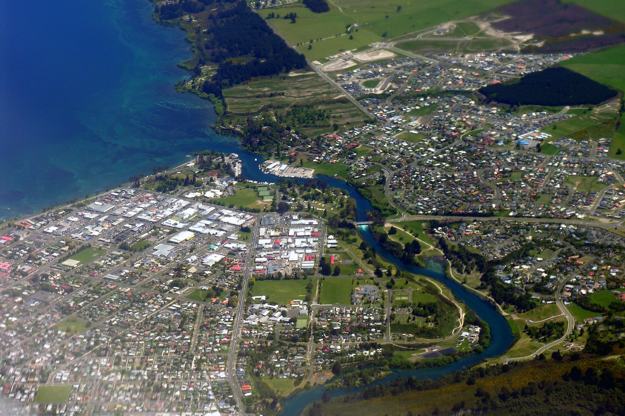
Aerial view of a lakeside town, with a deep blue lake on the left and a river winding out of it past streets and houses

Rotorua, Waikato & the Bay of Plenty, New Zealand

Taupō

Taupō from the air, with Lake Taupō on the left and the Waikato River leaving the lake through the town. (Phillip Capper from Wellington, New Zealand / Wikimedia Commons · CC BY 2.0)

A resort town on the north-eastern shore of Lake Taupō, at the point where the Waikato River leaves the lake, in the middle of the North Island's volcanic plateau. It grew from a constabulary post into a trout-fishing and holiday town, and now lives on tourism, geothermal energy and forestry, with the Huka Falls and Tongariro's volcanoes nearby.

Neighbourhoods

  • Town centre and the lakefront
    • First-time visitors
    • Best for food
    • Close to public transport

    A small grid of streets a few minutes' walk from the water, with most of the town's shops, cafés, bars and tour desks along the two main streets. The lakefront park, the boat harbour and the museum are at its edge, and the intercity coaches stop here.

    Open in Maps
  • Lake Terrace and Two Mile Bay
    • Lake views
    • Swimming
    • Quiet and residential

    The strip of motels, holiday apartments and houses that runs south from the centre along the lake shore, looking across the water to the volcanoes on clear days. A path and a chain of small bays and swimming beaches follow the road.

    Open in Maps
  • Acacia Bay
    • Quiet and residential
    • Lake views
    • Holiday houses

    A wooded bay of holiday homes and permanent houses on steep ground a few kilometres west of the centre, with its own sheltered beaches and boat ramps. There are no shops to speak of, so it suits those with a car.

    Open in Maps
  • Wairakei
    • Geothermal sights
    • Golf
    • Walks

    The geothermal area north of the town, where steam pipes cross the scrub and the power station draws on the field below. A golf course, the bore fields and the road out to the Huka Falls are all in this area.

    Open in Maps
  • Kinloch
    • Quiet and residential
    • Boating
    • Walks

    A small lakeside village in a bay on the northern shore, reached by a road over the hills west of the town. It has a marina, a golf course and access to the Great Lake Trail mountain-bike and walking network.

    Open in Maps

Things to do

The lake and the Waikato River

  • Lake Taupōattraction

    New Zealand's largest lake, filling the caldera of a volcano, used for sailing, kayaking, swimming and trout fishing, with boat trips leaving from the town harbour.

    Open in Maps
  • Huka Fallslandmark

    The Waikato River squeezes into a narrow rock canyon a few kilometres north of the town and drops in a pale blue torrent, one of the highest-flowing waterfalls in the world, seen from lookouts above the canyon.

    Open in Maps
  • Aratiatia Rapidslandmark

    A gorge downstream of the Huka Falls that fills and empties when the gates of a hydroelectric dam are opened at set times each day.

    Open in Maps
  • Mine Bay Māori rock carvingslandmark

    Carvings about ten metres high, cut into the cliffs on the lake's north-western side in the late 1970s in the likeness of the navigator Ngātoro-i-rangi, reachable only by boat or kayak from the town.

    Open in Maps

Geothermal ground

  • Craters of the Moonattraction

    A boardwalk loop through steaming vents, mud pools and craters on a geothermal field whose activity increased after the power station began drawing off steam.

    Open in Maps
  • Wairakei Power Stationlandmark

    The world's first wet-steam geothermal power station, built in 1958, its steam pipes and bore fields visible from the road north of town.

    Open in Maps

Walks and viewpoints

  • Mount Tauharaviewpoint

    A lava-dome hill east of the town, climbed on a steep track through bush to a summit that looks over the lake and the plateau.

    Open in Maps
  • Great Lake Trailtrail

    An 88-kilometre walking and mountain-biking trail in four sections centred on Kinloch, above the lake's northern bays, part of the New Zealand Cycle Trail.

    Open in Maps

Short trips from the town

  • Tongariro National Parkpark

    New Zealand's oldest national park and a UNESCO World Heritage site, south of the lake, holding the active volcanoes Ruapehu, Ngauruhoe and Tongariro, the Tongariro Alpine Crossing and three ski fields on Ruapehu.

    Open in Maps
  • Orakei Korakoattraction

    A geothermal area of silica terraces, geysers and a cave beside a reservoir on the Waikato River, reached by a short boat crossing.

    Open in Maps
  • Tongariro Riverattraction

    New Zealand's most fished river, which passes Tūrangi before entering the lake, known for the rainbow and brown trout that run up it from the lake to spawn in winter.

    Open in Maps

Seasonal events

  • Ironman New Zealandautumn

    A long-distance triathlon held in Taupō, with its swim in the lake and its bike and run courses on the roads around the town.

  • Lake Taupō Cycle Challengelate November

    New Zealand's largest mass-participation cycling event, first held in 1977 and run on the last Saturday of November, its main course a 160-kilometre circuit of the lake.

  • Summer holidayslate December to January

    The town's busiest season, when New Zealand families fill the motels, campgrounds and holiday houses and outdoor concerts are sometimes staged by the lake.

Eat and drink

Long-standing places and food districts in Taupō. Hours, ratings and directions come from your maps app, always current.

Food streets and markets

  • The town centreneighborhood

    The main run of restaurants, bakeries, pubs and takeaways in the centre, a mix of New Zealand café food, Asian kitchens and pizza places.

    Open in Maps
  • The lakefront on Lake Terraceneighborhood

    Restaurants and bars facing the water between the centre and Two Mile Bay, where much of the town's evening eating happens in summer.

    Open in Maps

Cafés and bars

  • Cafés around the town centrecafe

    Taupō keeps the standard New Zealand café pattern of espresso, counter food and brunch, with several places within a block or two of the lakefront.

    Open in Maps
  • Wairakei and the highway northneighborhood

    Roadside stops and dining rooms on the way out to the Huka Falls and the geothermal fields.

    Open in Maps

Experience Taupō

History

Ngāti Tūwharetoa have held the land around the lake since their ancestors moved inland from the Bay of Plenty coast, and the full name of the lake, Taupō-nui-a-Tia, honours the explorer Tia. The lake itself fills a caldera left by enormous eruptions, the most recent around the year 232, which covered much of the central North Island in ash and remade the Waikato River's outlet.

European settlement at the lake outlet began as a military post. An armed constabulary post was set up in 1868 to strengthen communications across the central North Island, and in 1870 a redoubt was built to guard the river crossing opposite the Ngāti Tūwharetoa pā at Nukuhau; a settlement of traders and constabulary grew around it, linked to the coast by rough roads. Progress was slow for decades: the pumice soils were poor for farming, and the town remained a stop on the way to the volcanoes. What changed it was fish. Rainbow trout, introduced to the lake in the 1890s, thrived there and in its rivers, and Taupō became a place people came to stay and fish, with fishing lodges and launches on the harbour.

The 20th century then brought industry. Exotic pine forests were planted across the plateau, the Wairakei geothermal field was developed for electricity from the 1950s, and hydroelectric dams were built down the Waikato. State Highway 1 runs through the town, which grew into the North Island's main inland holiday destination, adding bungy jumping, skydiving and jet-boating to fishing and boating from the 1980s onwards.

Culture & Customs

Taupō's identity is built around the lake, and the calendar follows it: boats and jet skis in summer, trout in the colder months, and a long-standing fishing culture with its own etiquette about pools, licences and quiet water. The town is also one of New Zealand's adventure-sport centres, with the country's busiest parachute drop zone at the airport, which makes skydiving one of the sights as much as an activity, and with endurance events — triathlon and a cycling circuit of the lake — that bring in thousands of competitors and give the place a sporting reputation out of proportion to its size.

Māori culture is present rather than staged. This is Tūwharetoa territory, with marae around the lake and at Tūrangi, and the paramount chief's line, the Te Heuheu family, gave the volcanic summits to the Crown in 1887, the gift that led to the creation of Tongariro National Park. Carvings on the cliffs at Mine Bay, cut in the late 1970s by Matahi Whakataka-Brightwell and John Randall, are among the best-known modern Māori artworks in the region.

Otherwise the manners are those of small-town New Zealand: informal, outdoor, practical. The population swells with holiday-home owners from Auckland, Hamilton and Taranaki over Christmas, a division locals note wryly, and the town empties again in the shoulder seasons. Volunteer clubs — surf and boating, rugby, tramping, search and rescue — hold much of the social life together.

Daily Life

About 27,000 people live in Taupō, in a district of about 43,000 that also takes in Tūrangi at the southern end of the lake. The resident population is older than the national average, and a large share of the housing stock is holiday homes, so the town's real size changes sharply with the season.

Work comes from three main sources. Tourism and hospitality employ many people, with obvious seasonal peaks. Energy is the quiet mainstay: the geothermal fields at Wairakei and nearby, and the chain of hydroelectric stations on the Waikato River, generate a significant part of the country's electricity and support skilled technical jobs. Forestry and wood processing on the pumice plateau make up the third, along with farming that has grown on fertilised pumice soils.

Daily life is car-based and spread along the lake. Families live in the suburbs behind the centre — Hilltop, Richmond Heights, Nukuhau and Rainbow Point among them — and use the centre for shopping and the lakefront for recreation. Local concerns include housing costs driven up by holiday-home demand, the health of the lake and the rivers that feed it, and the seasonal strain of a small town serving large visitor numbers. The lake is the town's chief asset, and arguments about how to protect it are never far away.

Food

Taupō eats like a New Zealand holiday town: cafés serving flat whites, eggs and counter food through the morning, bakeries with mince and cheese pies, fish-and-chip shops by the water, and restaurants along the lakefront that lean on lamb, beef, salmon and seasonal vegetables. Summer cooking is largely barbecue cooking, in back gardens and at campgrounds.

The local speciality is not sold in shops. The rainbow and brown trout of the lake and its rivers reach the table through fishing — smoked over mānuka chips, pan-fried, or made into pâté — and some restaurants will cook an angler's own catch. Salmon, often smoked or cured, stands in for it on most menus. Giant river prawns are farmed just north of the town on hot waste water from the Wairakei power station, at what is the country's only prawn farm.

Māori food traditions run through the area in the form of hāngī, meat and vegetables cooked in an earth oven, and kai from the lake and bush; rēwena, the slightly sour potato-starter bread, appears at markets and community events. The surrounding country supplies the rest: honey from the plateau, berries, sweetcorn and stone fruit in late summer, and beer from small breweries in the town.

Planning tools

Budget

Taupō is a domestic holiday town, so accommodation is the main variable: motel and holiday-house rates rise sharply over the Christmas and January school holidays and for race weekends, and fall in winter. Adventure activities are the other big cost, with skydiving, bungy jumping, jet-boat rides and lake cruises all priced as one-off treats. The lake, the Huka Falls and the Craters of the Moon boardwalk cost little or nothing.

Daily Budget Midrange
USD 150–260 (motel or lake-view apartment, restaurant meals, a hire car, one or two paid attractions)
Daily Budget Shoestring
USD 65–110 (hostel bed or campsite, self-catering, lake walks and free lookouts, no paid activities)

Book well ahead for January and for the Ironman and cycle-challenge weekends, when the town fills; midweek stays outside the school holidays are much cheaper.

Best Time to Visit

December to March is warmest and best for swimming, boating and the walks in Tongariro National Park, but it is also when the town is fullest and dearest. Late spring and early autumn are quieter and still mild. Winter brings frosts and clear cold days, the ski season on Ruapehu and the best of the trout fishing, and hot pools make more sense than the lake.

Suggested Number of Days

Two to three days covers the town, the lake and the river sights. Four or five allow for the national park to the south or the geothermal areas towards Rotorua. Weather matters more than distance here: a cloudy or windy spell rules out the lake and the alpine tracks.

First Visit
2–3 days
With Surroundings
4–5 days

Transportation

There is no urban public transport network to speak of. A car is the normal way to get around, and most visitors arrive in one; intercity coaches call at the centre, and shuttles run to the Tongariro Alpine Crossing trailheads and to the ski fields in season. Taxis and ride-hailing exist but are thin outside the centre. Bikes are widely hired for the lakeside path and the bush trails.

Distances between the sights north of town are short but the highway is fast, and roads over the plateau can be icy on winter mornings.

Airport & Station Connections

Most people drive. Taupō is about 280 kilometres south of Auckland, four hours or so on State Highway 1, roughly an hour from Rotorua, about 150 kilometres from Napier over the Napier–Taupō road, and five hours or more from Wellington. Intercity coaches serve all these routes. Taupō Airport, eight kilometres south of the centre, has Air New Zealand flights to Auckland. There is no passenger rail service to the town.

Walkability

The centre is flat, compact and easy on foot, and a path follows the lake shore south past the small swimming bays for several kilometres. Beyond that the town spreads out along the highways, and the bays on the western side, the Huka Falls and the geothermal areas are too far to reach on foot from most accommodation.

Safety

Taupō is a low-crime holiday town, and the real risks are natural. The lake is large enough to raise sudden waves and its water stays cold; the Waikato River runs fast and is dangerous above the falls; geothermal ground can be thin and scaldingly hot, so boardwalks and marked paths matter. The alpine tracks in Tongariro National Park change with the weather and need proper gear.

Watch the marine and mountain forecasts before going out on the lake or into the national park, stay on formed paths in geothermal areas, and leave nothing visible in a parked car at trailheads. Check current official travel advice before travelling.

Climate

A temperate inland climate, cooler than the coast because the town sits high on the volcanic plateau. Summer is December to February, winter June to August. Rain falls through the year, and the lake breeds its own wind and cloud.

Summer
warm and often settled — days typically in the low to mid 20s °C, cool evenings, and the water warm enough for swimming
Winter
cool and frosty — days around 11–13 °C, night frosts common, snow on the volcanoes to the south rather than in the town

Local Customs

New Zealand manners are informal: first names, casual dress, shoes often left at the door of a home. Tipping is not expected and service charges are rare. The district is the rohe of Ngāti Tūwharetoa, ; on a marae, visitors wait to be welcomed and follow their hosts' lead, and food and drink are kept away from sacred places.

Ask before photographing people, carvings or marae; do not swim or wash with soap in hot springs used by others; alcohol may not be bought under 18.

Common Payment Methods

The currency is the New Zealand dollar. Cards and contactless payment, including the local EFTPOS system, are accepted almost everywhere, and some businesses add a small surcharge for card use. ATMs are in the town centre. Cash is rarely needed beyond small markets and honesty boxes.