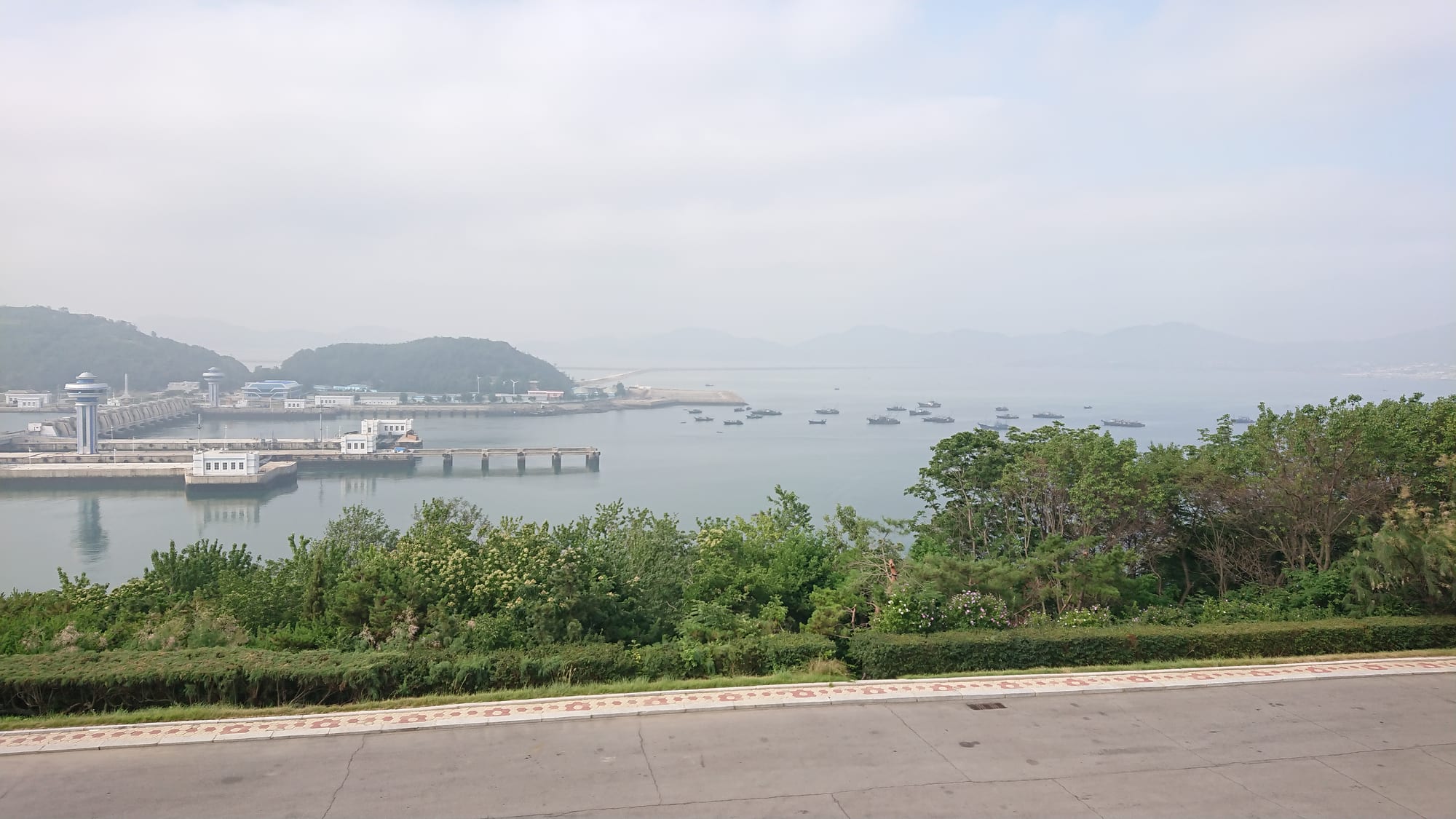
A wide river mouth with a low dam and lock structures on the left, small boats moored offshore and green hills fading into haze

Pyongyang & the West, North Korea

Nampo

The West Sea Barrage across the Taedong estuary near Nampo. (Jan Engelhardt / Wikimedia Commons · CC BY-SA 4.0)

North Korea's main west-coast port, at the mouth of the Taedong River about 50 kilometres downstream from Pyongyang. A fishing and trading village opened to foreign commerce in the 1890s, it became an industrial city of shipyards, smelters and docks, and is best known for the West Sea Barrage across the estuary. This page is written to explain the city, not to encourage travel.

Neighbourhoods

  • The port and dock quarter
    • Industry
    • Waterfront

    The working heart of the city, where the quays, cranes, shipyard and warehouses line the Taedong. Most of Nampo's economy is tied to what moves across these docks, and the area is closed to casual wandering.

    Open in Maps
  • The central district
    • First-time visitors
    • Monuments

    Apartment blocks, offices, a theatre and the usual monuments arranged around the main avenue inland from the water. It is smaller and plainer than the equivalent quarter in Pyongyang, and this is where visiting groups are generally housed.

    Open in Maps
  • The industrial belt
    • Industry
    • Local life

    Smelters, glassworks and engineering plants on the landward side of town, with housing for their workforces built alongside. The area gives Nampo the look of a factory city rather than a seaport.

    Open in Maps
  • The estuary shore and Waudo
    • Waterfront
    • Quiet and residential

    Low ground and mudflats stretching west towards the barrage, with a bathing area and park space along the coast used by residents in summer. The wide estuary views are the city's best feature.

    Open in Maps

Things to do

The estuary

  • West Sea Barragelandmark

    An eight-kilometre system of dams, three lock chambers, 36 sluices and a road across the Taedong estuary, built by the army between 1981 and 1986 to keep seawater out of the river and presented by the state as a feat of self-reliant engineering.

    Open in Maps
  • Nampo porttransit hub

    The country's main west-coast harbour, handling cargo, coal and the shipyard's work, and the reason the city grew; it is viewed from a distance rather than visited.

    Open in Maps
  • The estuary shoreviewpoint

    Mudflats, tidal channels and low headlands west of the city, with the wide brown mouth of the Taedong opening to the Yellow Sea.

    Open in Maps

Koguryo tombs

  • Kangso Three Tombslandmark

    Three large earth mounds covering painted burial chambers of the Koguryo kingdom, painted with the four directional guardian animals — a blue dragon and a black tortoise in the largest, a white tiger and a red phoenix in the middle one — and part of a UNESCO World Heritage Site.

    Open in Maps
  • Tokhung-ri tomblandmark

    A Koguryo tomb on the plain behind the city, with wall paintings of processions, hunting and daily life; fifth-century tombs in this area are also part of the World Heritage listing.

    Open in Maps

The city and around

  • The central avenue and monumentslandmark

    The main street of the central district, with the mosaics, statues and slogan boards that mark every North Korean city centre.

    Open in Maps
  • The hot spring resort at Ryonggangattraction

    A spring and spa area inland from the coast, in the apple-growing county of Ryonggang, long used for mineral baths.

    Open in Maps
  • The coastal farmlandviewpoint

    Reclaimed fields, orchards and fruit farms spread across the flat land behind the estuary, part of the western plain that feeds the capital.

    Open in Maps

Seasonal events

  • Day of the SunApril

    The 15 April anniversary of Kim Il-sung's birth is marked here as everywhere, with flower-laying at the city's monuments and public events; since 2024 state media have used the name less, calling it simply the April holiday.

  • National DaySeptember

    The anniversary of the state's founding on 9 September, marked with rallies and workplace ceremonies across the port and its factories.

  • Kimjanglate autumn

    The communal making of the year's kimchi supply in November, an organised effort in workplaces and neighbourhoods as much as a family task.

Eat and drink

Long-standing places and food districts in Nampo. Hours, ratings and directions come from your maps app, always current.

Coastal eating

  • Tour and hotel restaurantsrestaurant

    Meals for foreign visitors are arranged by the tour at a fixed set of state restaurants and hotels rather than chosen, so where to eat is not a decision made here; seafood features more heavily than in Pyongyang.

    Open in Maps
  • Clam grilling on the shorerestaurant

    Shellfish grilled over petrol poured onto a tray of clams is a coastal speciality of this stretch of the west sea, sometimes laid on for groups near the barrage.

    Open in Maps
  • Fruit from the western plainmarket

    Apples from the orchards of Ryonggang county, behind the city, are a well-known local product, sold and distributed widely in the capital.

    Open in Maps

Experience Nampo

History

The mouth of the Taedong has been a way in to the interior for as long as Pyongyang has mattered, and the tombs of the Koguryo kingdom scattered across the plain behind the estuary show how populated this stretch of coast was by the fifth century. The settlement itself stayed small — a fishing and trading point on a tidal river — until the late nineteenth century, when the port then known as Chinnampo was opened to foreign trade in the 1890s and quickly grew into the outlet for Pyongyang's commerce.

Under Japanese rule from 1910 the port was expanded and industrialised, with smelting, engineering and glass works drawing labour from the countryside and rail lines built to carry ore and coal; the port had been opened to foreign trade in 1897, when it was known as Chinnampo, a name given under Japanese influence and later shortened to Nampo. The Korean War brought heavy bombing to the docks and factories, and the city was rebuilt afterwards along with the rest of the country's industrial base.

The defining project of its modern history is the West Sea Barrage, completed in 1986 after years of work: an eight-kilometre dam with locks and a road across the estuary, built to hold back the sea, secure fresh water for irrigation and industry and carry traffic across the river mouth. It is shown to visitors as evidence of self-reliance. Nampo has since been reorganised administratively more than once — a directly governed city from 1980 to 2004 and a special city, taking in surrounding counties, since 2010 — and it remains a principal west-coast port, handling much of its seaborne trade and shipbuilding.

Culture & Customs

Nampo is a working city rather than a ceremonial one, and its character comes from the port and the factories: workplaces organise much of social life, from study sessions and sports teams to the mobilisations that send crews to help with planting and harvest on the surrounding farms. The public culture is the same as the capital's — monuments, mosaics, slogan boards and the calendar of political anniversaries — but staged on a smaller scale.

The area's older layer is unusually deep. The painted Koguryo tombs at Kangso and Tokhung-ri, with their guardian animals, processions and scenes of daily life from the fourth and fifth centuries, are among the most important early Korean monuments anywhere, and they are presented locally as evidence of a long and independent Korean civilisation. Traditional holidays are still marked, with visits to ancestral graves at the lunar new year and Chuseok.

Coastal habits shape the rest: fishing families, shellfish gathering on the mudflats at low tide, and summer bathing along the shore west of the city. As elsewhere in the country, the UN Commission of Inquiry of 2014 documented systematic human-rights abuses, and songbun, the classification of families by political background, governs access to education, work and housing here as in every other city.

Daily Life

Nampo is the country's fourth-largest city by population: the 2008 census counted about 367,000 people in the special city, some 311,000 of them in the urban districts and the rest in the farming counties along the coast. Life divides between the apartment blocks of the central district, the housing estates attached to the big plants, and villages of low tiled houses among the fields and orchards inland.

Work is dominated by the port, the shipyard, the smelters and glassworks, and by the farms of the western plain, which is the country's main rice-growing region and supplies fruit as well; the orchards of Ryonggang county are known nationally for their apples. Since the 1990s famine, household economies have leaned on markets and private trade alongside state wages, and a port city with shipping connections sees more imported goods than inland towns of the same size.

The practical texture of life is set by shortages: electricity is intermittent outside priority industries, heating in winter relies on coal, and food prices in the markets are watched closely. Commuting is done on foot, by bicycle and on crowded buses. Since the border closure of 2020 reduced trade, the docks have been quieter than they were, and the city's fortunes follow the volume of goods moving through them.

Food

The estuary and the Yellow Sea give Nampo a stronger seafood tradition than inland cities. Clams, oysters and other shellfish are gathered on the tidal flats and eaten grilled, steamed or in soups, and the local speciality is a shore cooking method in which clams are laid on a tray, doused with petrol and set alight so that they open in the flame. Grey mullet, croaker, crab and squid come in with the boats, and fish is dried on racks along the shore for the winter.

The farmland behind the city supplies the rest. This is the country's rice bowl, so rice appears more often than the maize that dominates in the mountain provinces, and the orchards inland produce the apples that are among the area's best-known products. Cabbage, radish and chilli from the same fields go into kimchi, and kimjang, the autumn making of the year's supply, is organised through workplaces and neighbourhoods as well as households.

Cooked dishes follow the western Korean pattern: kimchi and soybean paste stews, noodle dishes including the chilled buckwheat raengmyeon claimed by Pyongyang, and nokdu jijim, thick mung-bean pancakes, at holidays. Taedonggang beer from the capital and locally distilled soju are the usual drinks.

Planning tools

Budget

There is no independent budget for Nampo. When tourism has operated, the city has been reached only as an excursion from Pyongyang on a fixed all-inclusive tour paid in advance to a state-approved agency, with the side trip added to the programme at extra cost. Cash spending is confined to souvenirs and drinks at approved stops.

Daily Budget Midrange
USD 170–400 (an all-inclusive group tour from Pyongyang, when tours run: hotel, meals, guides and transport)
Daily Budget Shoestring
USD 170–400 (no cheaper option exists — independent travel is not permitted, so the tour price is the floor)

Tourism closed in January 2020; foreigners were let in again in February 2025, to Rason and not this part of the country, before the border shut once more a month later. If a tour ever runs, carry euros or Chinese yuan in small notes.

Best Time to Visit

Late April to June and September to October have been the mildest and driest months for the guided tours that historically ran, with blossom in the orchards in spring and clear estuary views in autumn. July and August are hot, humid and wet, with flood risk on the Taedong, and winter on this coast is cold and windy.

Suggested Number of Days

Nampo has usually been seen as a half-day excursion from the capital, or an overnight stop combined with the barrage and the Koguryo tombs. The length is set by the operator and the approved programme rather than by the visitor.

First Visit
Half a day
With Surroundings
1–2 days

Transportation

Visitors move only by chartered bus or car with guides on approved roads; the Youth Hero Motorway links the city with Pyongyang in about an hour. Residents use buses, bicycles and a suburban rail line, and the port has rail connections for freight. Movement between counties requires a permit for North Koreans.

No independent movement is allowed, and the docks, shipyard and industrial plants are not places to approach or photograph.

Airport & Station Connections

Nampo lies about 50 km south-west of Pyongyang, roughly an hour by road on the motorway that runs down the Taedong, which is how almost every visiting group arrives. There is a railway from the capital as well, and the port handles shipping rather than passengers. Access depends entirely on an approved tour arranged in advance.

Walkability

The central district is flat and compact enough to cross on foot, but in practice visitors walk only where and when guides allow, usually between a parked bus and a specific site. The port and industrial areas are closed, and the distances out to the barrage and the tombs are far beyond walking.

Safety

The danger is political rather than criminal. Ordinary crime against foreigners is essentially unknown under close supervision, but a port and industrial city means more restricted installations than usual: photographing the docks, shipyard, ships, soldiers, checkpoints or anything that reads as poverty can bring serious trouble, as can straying from the group or unsanctioned conversation with residents.

Most governments advise against all travel to North Korea and the US bans its citizens from going without special permission. Keep cameras down around the port and follow the guides' instructions exactly. Check current official travel advice before travelling.

Climate

Continental with a monsoon summer, moderated a little by the Yellow Sea. Most of the rain falls in July and August, when the estuary is prone to flooding; spring and autumn are short, mild and dry, and sea fog is common in early summer.

Summer
hot and humid — often 25–30°C, with heavy monsoon rain and sea haze
Winter
cold and dry — daytime temperatures usually around 0 to −5°C, with a raw wind off the estuary

Local Customs

The rules that apply in Pyongyang apply here: formal behaviour at monuments, bowing where the group is asked to bow, and photographs of statues and portraits of the leaders shown whole and never cropped or creased. Neat dress is expected at memorials. Korean courtesies — two-handed giving and receiving, shoes off indoors, deference to age — are the everyday norm.

Ask the guides before taking any photograph, never photograph the port, ships or soldiers, and do not hand gifts or printed material to residents.

Common Payment Methods

The North Korean won is not available to visitors, who pay in euros, Chinese yuan or US dollars in cash at the few shops and counters open to foreigners. Foreign cards do not work and there are no international ATMs, so small notes are needed for anything bought outside the tour price.