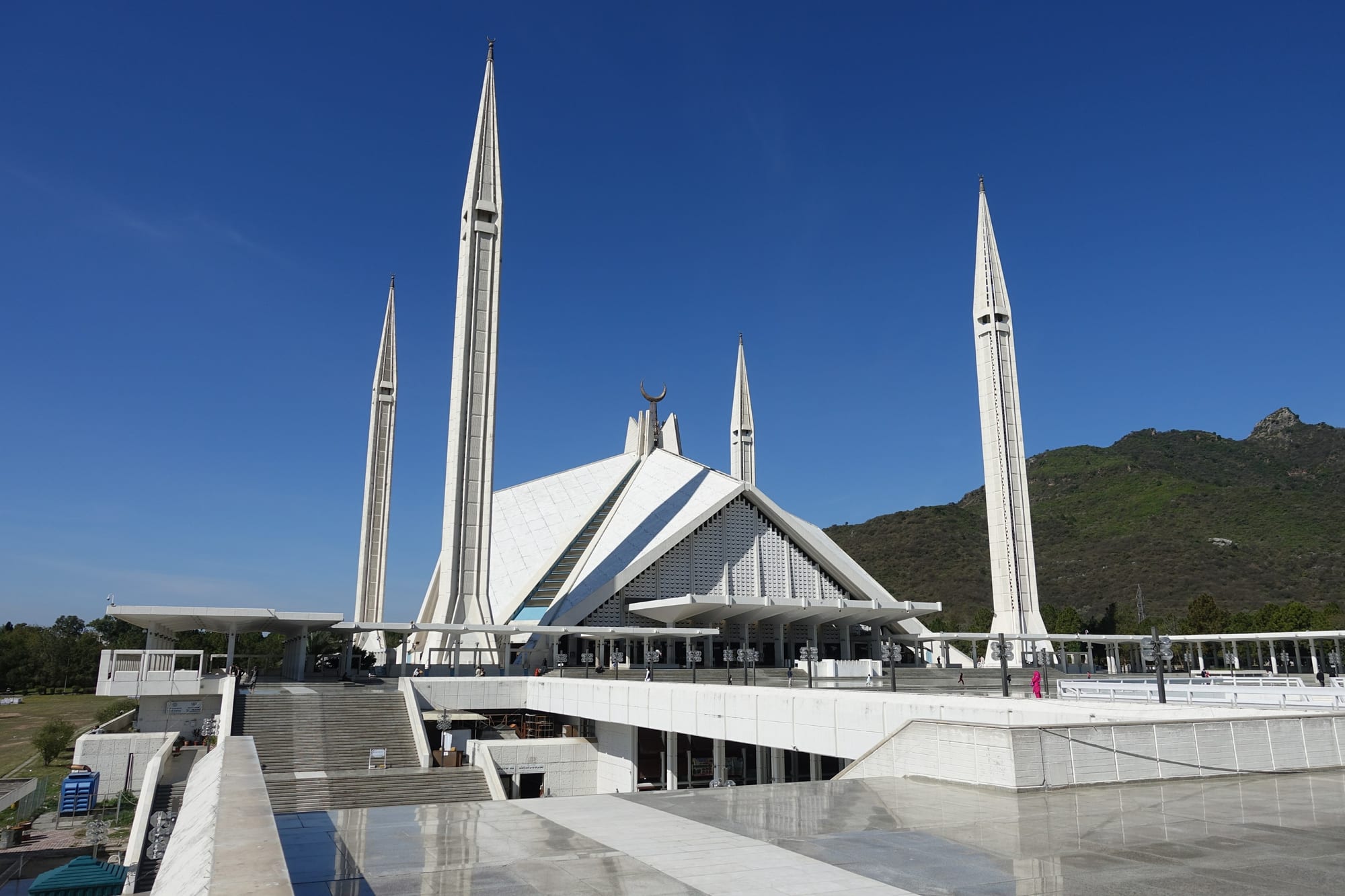
The white Faisal Mosque seen from its courtyard, with the tent-shaped prayer hall and tall slender minarets

Lahore, Islamabad & Punjab, Pakistan

Islamabad

The Faisal Mosque at the northern edge of Islamabad, below the Margalla Hills. (Marsmux / Wikimedia Commons · CC BY-SA 4.0)

Pakistan's purpose-built capital, laid out in lettered sectors below the Margalla Hills in the 1960s to replace Karachi as the seat of government. Green, quiet and low-rise by the standards of the country's older cities, it holds the Faisal Mosque, the diplomatic quarter and hill trails that start at the edge of the suburbs. This page is written to explain the city, not to encourage travel.

Neighbourhoods

  • Blue Area
    • Business district
    • Close to public transport

    The central commercial spine along Jinnah Avenue, a long line of office towers, banks, airline offices and restaurants between the government enclave and the residential sectors. The metro bus runs down its length, and it is the closest thing the capital has to a downtown.

    Open in Maps
  • F-6 and F-7
    • First-time visitors
    • Best for food
    • Shopping

    Two of the oldest residential sectors, laid out under the hills, with the Super Market and Jinnah Super shopping centres at their heart and the Kohsar Market nearby. Restaurants, bookshops, bakeries and embassies fill quiet, tree-lined streets, and many hotels and guesthouses are here.

    Open in Maps
  • The Diplomatic Enclave
    • Embassies
    • Quiet and residential

    A guarded compound in the north-east holding most foreign missions and some official residences. Access is controlled and casual visits are not possible, but anyone applying for a visa or consular service is sent here, usually by a shuttle from a checkpoint.

    Open in Maps
  • G-6 and Aabpara
    • Local life
    • Markets
    • Close to public transport

    One of the first sectors built, with smaller houses and flats, the busy Aabpara market and the Melody food centre. This is the most ordinary and most crowded part of the planned city, and prices are lower than in the F sectors.

    Open in Maps
  • E-7 and the Margalla foothills
    • Quiet and residential
    • Walks and viewpoints

    Large houses on rising ground directly below the hills, where several trailheads into Margalla Hills National Park begin. The air is cooler than on the plain and the views over the city are wide, but almost nothing is within walking distance.

    Open in Maps
  • Rawalpindi's Saddar
    • Historic district
    • Street food
    • Markets

    The colonial-era bazaar quarter of the twin city, about 15 km south, all narrow lanes, cloth shops, tea stalls and old buildings. It is louder, older and cheaper than anywhere in Islamabad and is where many visitors go for a sense of everyday Punjab.

    Open in Maps

Things to do

Famous landmarks

  • Faisal Mosquelandmark

    The national mosque, completed in 1986 to a design by the Turkish architect Vedat Dalokay, shaped like a desert tent and set against the hills.

    Open in Maps
  • Pakistan Monumentlandmark

    A granite monument on the Shakarparian hills whose four large and three smaller petals stand for the country's major and minor cultures, with a view over the whole capital.

    Open in Maps
  • Saidpur Villageneighborhood

    An old Mughal-era village absorbed by the city at the foot of the Margalla Hills, with a restored temple and gurdwara complex and a lane of restaurants.

    Open in Maps
  • Shah Allah Ditta cavesattraction

    Caves and an old caravan route on the western edge of the city, used by Buddhist monks and later by Hindu ascetics, beside a village with banyan trees and tea stalls.

    Open in Maps

Museums

  • Lok Virsa Museummuseum

    The national heritage museum at Shakarparian, run by the National Institute of Folk & Traditional Heritage, with rooms of crafts, costume, jewellery and music from every province.

    Open in Maps
  • Pakistan Museum of Natural Historymuseum

    The national natural history collection at Shakarparian, with fossils, minerals and a hall on the wildlife of Pakistan.

    Open in Maps

Parks, hills and viewpoints

  • Margalla Hills National Parkpark

    Wooded limestone hills rising straight behind the city, with numbered walking trails, monkeys, birdlife and long views over the plain.

    Open in Maps
  • Daman-e-Kohviewpoint

    A terraced viewpoint partway up the Margalla Hills, reached by road or on foot, looking down the axis of the city to the Faisal Mosque.

    Open in Maps
  • Rawal Lakepark

    A reservoir on the Korang river on the eastern edge of the capital, with a lakeside park, boating and a view of the hills.

    Open in Maps
  • Shakarparianpark

    A wooded ridge of gardens between Islamabad and Rawalpindi holding the monument, the museums and the Lok Virsa open-air stages.

    Open in Maps
  • Fatima Jinnah Parkpark

    A very large public park spanning the whole of sector F-9, with lawns, walking paths, sports grounds and stretches of near-wild woodland, busy in the early evening.

    Open in Maps
  • Pir Sohawaviewpoint

    A ridge-top spot high above the city at the end of the Margalla road, cooler than the plain, with restaurants overlooking the capital.

    Open in Maps

Short trips from the city

  • Taxilaattraction

    The Gandharan city and Buddhist monastery sites about 30 km north-west, a UNESCO World Heritage Site, with a museum of stone sculpture.

    Open in Maps
  • Murreeattraction

    A British-built hill station about 40 km north-east at around 2,300 m, cool in summer and snowy in winter, reached by a mountain road.

    Open in Maps
  • Raja Bazaar, Rawalpindimarket

    The dense old market at the heart of Rawalpindi, a grid of specialised lanes for cloth, spices, metalware and jewellery.

    Open in Maps
  • Liaquat Baghpark

    A public park in Rawalpindi remembered as the place where Prime Minister Liaquat Ali Khan was assassinated in 1951 and Benazir Bhutto was killed in 2007.

    Open in Maps
  • Pakistan Railways Heritage Museummuseum

    A collection of colonial-era locomotives, carriages and railway fittings at Golra Sharif Junction on the north-western edge of the city.

    Open in Maps

Seasonal events

  • Pakistan Day23 March

    The national day marking the Lahore Resolution of 1940 and the adoption of the first constitution in 1956, observed in the capital with ceremonies and, in some years, a military parade.

  • Independence Day14 August

    Flags, green and white lights along Jinnah Avenue and crowds in the Blue Area on the anniversary of independence in 1947.

  • Islamabad Literature Festivalspring

    Several days of sessions in Urdu and English on writing, history and politics, run by the organisers of the Karachi festival.

Eat and drink

Long-standing places and food districts in Islamabad. Hours, ratings and directions come from your maps app, always current.

Where the capital eats

  • Melody Food Parkneighborhood

    A cluster of long-running grills, karahi houses and sweet shops beside the Aabpara market in G-6, one of the oldest places to eat in the planned city.

    Open in Maps
  • Jinnah Super and Kohsar Marketneighborhood

    The two F-7 markets where much of the city's café, bakery and restaurant trade is concentrated, from Pakistani grills to Thai, Afghan and Italian kitchens.

    Open in Maps
  • Blue Area restaurantsneighborhood

    Office-district dining along Jinnah Avenue, busiest at lunchtime, with buffets, kebab houses and chains serving civil servants and business visitors.

    Open in Maps
  • Saidpur Village restaurantsneighborhood

    A short lane of restaurants in the restored village below the hills, popular for dinner in the cooler months.

    Open in Maps

Markets and street food

  • Aabpara Marketmarket

    A crowded general market in G-6 with fruit and vegetable stalls, spice shops and pavement cooks selling chana, samosas and pakoras.

    Open in Maps
  • Rawalpindi's Saddar and Raja Bazaarneighborhood

    The twin city's old bazaars, where halwa puri, nihari, chapli kebab and hot milk with cream are sold from small shops and carts.

    Open in Maps

Experience Islamabad

History

Islamabad is younger than most of its residents' grandparents. When Pakistan was created in 1947 the capital was Karachi, but the government found it remote from the army's headquarters at Rawalpindi and vulnerable on the coast. In 1959 a commission under President Ayub Khan chose a site on the Potohar plateau below the Margalla Hills, beside the existing city of Rawalpindi, and the Greek planner Constantinos Doxiadis was commissioned to design it. Construction began in the early 1960s, the government moved in from 1966, and the name — "city of Islam" — was chosen to signal the new state's identity.

The plan was a grid of square sectors, each about two kilometres to a side, each meant to be largely self-contained with its own market, mosque, schools and parks, arranged on a triangle with its apex towards the hills and designed to keep expanding away from them. Sectors were given a letter and a number, and the lettering still governs how people describe where they live. Rawalpindi served as the interim capital while the work went on, and the two cities have since grown into a single metropolitan area of very different halves.

The capital's history since has been national rather than local: military coups and civilian governments, the long consequences of the Soviet and later American wars in neighbouring Afghanistan, and the refugees, aid agencies and security apparatus that came with them. The bombing of the Marriott Hotel in 2008 and the siege of the Lal Masjid in 2007 were fought out in the capital's own streets. Protest marches from the provinces have repeatedly converged on the Red Zone, where parliament, the Supreme Court and the presidency stand. Building has continued south and east, and the sectors that were farmland in the 1960s are now dense suburbs.

Culture & Customs

Islamabad is the least Punjabi city in Punjab. Its population was assembled from every province — civil servants, army officers, academics, diplomats and, later, migrants from Khyber Pakhtunkhwa, Kashmir and beyond — so Urdu, rather than Punjabi, is the common language of the street, with English dominant in offices. The result is a capital with a reputation for being polite, cautious and a little dull, summed up in the old joke that Islamabad is half the size of a Karachi graveyard and twice as dead.

Its cultural life is institutional: the Pakistan National Council of the Arts, Lok Virsa's folk collections, the literature festival, embassy-sponsored concerts and film screenings, and a small circuit of galleries and bookshops in the F sectors. Qawwali, classical music and theatre appear in seasons rather than continuously. Hiking has become a genuinely local pastime: the Margalla trails fill with families and students on winter weekends, and trail numbers are common shorthand.

Social codes are those of Pakistan generally — modest dress, elders greeted first, hospitality pressed on guests, shoes removed indoors — with the added formality of a government town where rank matters and introductions are made carefully. The Friday midday prayer empties offices, and the Faisal Mosque draws tens of thousands. Weekends run Saturday and Sunday, and the city's evening life is domestic: dinner at home or in a market restaurant rather than anything resembling nightlife.

Daily Life

About 1.1 million people live in Islamabad proper and roughly 2.4 million in the Islamabad Capital Territory, while Rawalpindi next door holds more than two million more. The two form one urban area, joined by the Metrobus and by the tens of thousands who commute daily between a cheap old bazaar city and an expensive planned one.

Government is the economy. Ministries, the parliament, the courts, the central bank, the universities and the headquarters of national institutions employ a large share of the workforce, alongside embassies, international organisations, telecommunications and IT companies, and a construction industry that never stops. Property is the local obsession: housing societies spread across the plateau, and plot prices are a standard topic of conversation.

Daily rhythms are office-bound — early starts, a long lunch break around Friday prayers, heavy traffic on the main avenues at either end of the day. Families walk in the sector parks and Fatima Jinnah Park in the evening, and drive up to Daman-e-Koh or Pir Sohawa at weekends. Persistent problems include water supply from Rawal and Simly lakes in dry years, uncontrolled building on the fringes, encroachment on the national park, and the road closures and internet restrictions that accompany political protests. Air quality is better than Lahore's but no longer good, especially in winter.

Food

Islamabad has no cuisine of its own. Because it was populated from everywhere, its food is the food of the whole country brought together: Punjabi karahi and seekh kebabs, Peshawari chapli kebab — a flat, spiced beef patty fried in fat — and namkeen karahi from the north-west, Afghan pulao and mantu, Kashmiri gushtaba, and in the better restaurants Sindhi biryani and Balochi sajji, a whole lamb or chicken roasted on a stake.

Breakfast is the old Punjabi standard: halwa puri with chickpeas on Sundays, nihari or siri paye in Rawalpindi's bazaars, and doodh pati, tea boiled with milk. Street snacks are chana chaat, samosas, pakoras and dahi bhalla, sold at market corners in the late afternoon. In the hills above the city, corn roasted on charcoal and tea from roadside stalls are part of any weekend drive.

The eating geography is simple. Melody in G-6 and Aabpara have the older, cheaper grills; Jinnah Super and Kohsar Market in F-7 hold most of the cafés, bakeries and international restaurants; the Blue Area feeds office workers at lunch; and Saidpur Village and the Margalla ridge are where the city goes for dinner with a view. Sweets follow the Punjabi repertoire — gulab jamun, barfi, jalebi and, in winter, gajar ka halwa made from carrots, milk and ghee.

Planning tools

Budget

Islamabad is the most expensive city in Pakistan. Hotel rates are set by diplomatic and business demand, restaurants in the F sectors cost more than their equivalents elsewhere, and the sectors are far enough apart that transport adds up. Costs fall sharply for anyone eating in the markets or staying in Rawalpindi.

Daily Budget Midrange
USD 60–130 (good hotel, restaurant meals, ride-hailing cars, a car for the hills and Taxila)
Daily Budget Shoestring
USD 20–35 (guesthouse or hostel, market food, metro bus and shared rickshaws)

The best things in the capital cost nothing — the Margalla trails, the Faisal Mosque, the parks and the view from Daman-e-Koh; a hired car for a day is the cheapest way to reach Taxila and Murree.

Best Time to Visit

March and April, when the hills are green and the jacaranda and coral trees flower, and October to early November, which is dry and clear. May and June are hot, the monsoon in July and August brings heavy downpours and landslips on the hill roads, and winter is cool and grey, though the Margalla Hills stay walkable and snow falls only above the city at Murree.

Suggested Number of Days

The capital's own sights are few and spread out, and a day or two covers them. Three or four days make sense with the hills, Rawalpindi's bazaars and the archaeological sites to the west included. Many travellers use Islamabad mainly as a base or a transit point.

First Visit
1–2 days
With Surroundings
3–4 days

Transportation

The city was designed for cars, and its sectors are large, so ride-hailing apps and taxis do most of the work for visitors. The Metrobus runs on a dedicated corridor from the Blue Area south into Rawalpindi, with a second line west to the airport, and it is cheap and reliable. Within a sector, short hops are made by rickshaw or on foot.

Sector addresses follow a code — a letter, a number, then a sub-sector, as in F-7/2 — and giving the sector and the nearest market is the quickest way to direct a driver.

Airport & Station Connections

Islamabad International Airport, opened in 2018 near Fateh Jang, is about 25 km south-west of the city and is Pakistan's main gateway alongside Karachi and Lahore, with Gulf, Chinese, Turkish and British connections. Motorway coaches reach Lahore on the M-2 in roughly four and a half hours and Peshawar on the M-1 in about two. Long-distance trains use Rawalpindi station rather than the capital itself.

Walkability

Islamabad walks well inside a sector and badly between them. Each sector has its own market, mosque and parks within a few minutes on foot, and the F-6 and F-7 streets are shaded and quiet, but the avenues separating sectors are wide, fast and often without pavements. The Margalla trails and the parks are the real walking here, and summer heat limits the hours that are comfortable.

Safety

Islamabad is the most heavily policed city in the country and everyday crime is low, but it is not free of terrorism: militants have attacked the Marriott Hotel and other targets in the capital in past years, and checkpoints, barriers and bag searches are part of daily life. Political protests and marches converge on the capital and can close roads and motorway entrances at short notice, sometimes with mobile internet restrictions. Practical risks are traffic, heat, monkeys on the hill trails and walking alone on quiet trails after dark.

Security checks are routine at hotels, malls and government buildings; the Diplomatic Enclave and the Red Zone need permission to enter, protests and rallies are best avoided, modest dress is expected, and hill trails are better walked in company. Check current official travel advice before travelling.

Climate

A humid subtropical climate, cooler and wetter than the plains because of the hills. Spring and autumn are short and pleasant, summer is hot with violent monsoon storms, and winter is cool with occasional frost at night and hail in spring.

Summer
hot — May and June days reach 35–40°C, followed by humid monsoon rain in July and August, the wettest months of the year
Winter
cool — December to February days are around 12–18°C with nights near freezing, and snow falls in the hills above the city

Local Customs

The capital is more cosmopolitan than the rest of Punjab but still conservative. Modest dress covering arms and legs is expected, and women carry a scarf for mosques and shrines, where shoes are removed at the door. The Faisal Mosque welcomes non-Muslim visitors outside prayer times. Photography of people should be asked about first, and government buildings, checkpoints and the Diplomatic Enclave must not be photographed at all.

Greet with 'assalam-o-alaikum' and use the right hand for eating and giving; alcohol is not sold openly and is limited to a few licensed outlets for foreigners; and restaurants keep reduced daytime service during Ramadan.

Common Payment Methods

The currency is the Pakistani rupee. Cards are accepted in hotels, malls and larger restaurants more widely here than elsewhere in the country, but markets, rickshaws and small kitchens are cash-only. ATMs are plentiful in the Blue Area and the sector markets, though not all take foreign cards, so carrying a cash reserve is sensible.