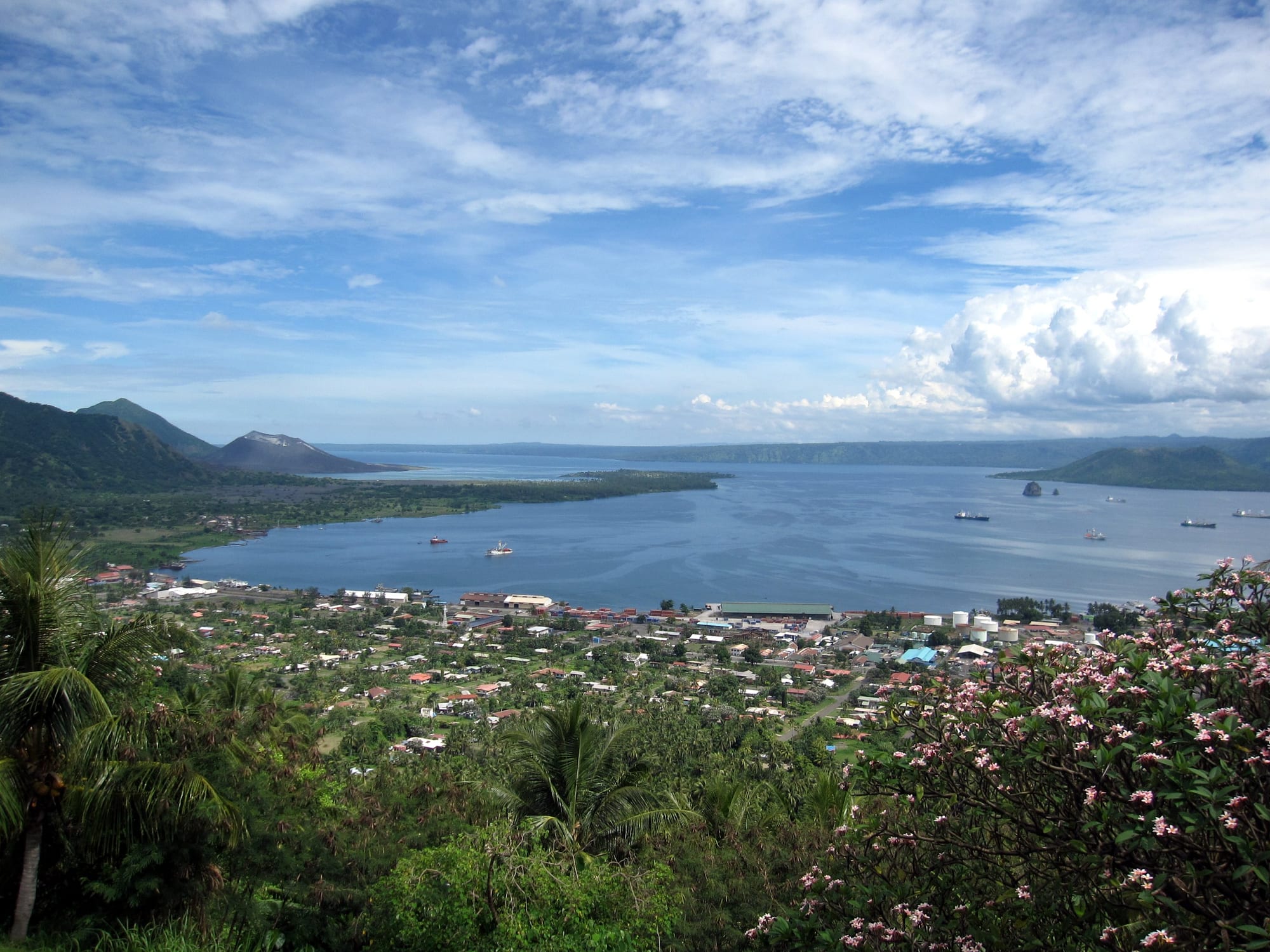
A low town of red and grey roofs among palms beside a wide blue harbour, with green volcanic cones on the far shore

The Islands Region, Papua New Guinea

Rabaul

Rabaul and Simpson Harbour seen from the ridge holding the volcano observatory, with the caldera's cones beyond. (Stefan Krasowski / Wikimedia Commons · CC BY 2.0)

A port town on Simpson Harbour at the north-eastern tip of New Britain, built inside a drowned volcanic caldera. Capital of German New Guinea and then of the Australian territory, it became Japan's main South Pacific base in the Second World War, and was buried by ash from Tavurvur and Vulcan in 1994. A smaller town now works beside the ruins.

Neighbourhoods

  • The rebuilt town centre
    • First-time visitors
    • Markets
    • Close to the water

    The working part of Rabaul, on the western side of the harbour, with the market, trade stores, the port and a few guesthouses. It is low-built and dusty, and the volcano is visible from almost every street.

    Open in Maps
  • The buried old town and Matupit
    • Historic sites
    • Volcano views

    East and south of the centre lie the ash flats of the pre-1994 town, where roofs, walls and the old airport runway stand in hardened grey ash. The village of Matupit sits out on this ground near the foot of Tavurvur, and boats leave from here for the hot springs and beaches along the shore.

    Open in Maps
  • Namanula and the ridges
    • Views
    • Quiet and residential

    The hills above the harbour hold the volcano observatory, government houses and old colonial sites, with long views over the caldera and the ships at anchor. The road up is steep and the air noticeably cooler.

    Open in Maps
  • Malaguna and the coast road west
    • Local life
    • Everyday shopping

    The residential stretch running west out of town towards Kokopo, lined with houses, churches, schools, small markets and workshops. Public motor vehicles run along it constantly, and most people who work in Rabaul live here or further along the bay.

    Open in Maps

Things to do

Volcanoes and viewpoints

  • Tavurvurlandmark

    The active cone across the harbour whose 1994 eruption, with Vulcan on the opposite side, buried the town in ash, and which has erupted intermittently since, most recently of note in 2014.

    Open in Maps
  • Rabaul Calderaattraction

    The great collapsed volcano whose flooded floor forms Simpson Harbour, ringed by cones including Tavurvur and Vulcan.

    Open in Maps
  • Rabaul Volcanological Observatoryviewpoint

    The government monitoring station set up on the northern ridge of the caldera in the 1950s, which watches the volcanoes here and on nearby islands, and gives the classic view over the harbour and the cones.

    Open in Maps
  • Rabaul Marketmarket

    The town's produce market, where villages around the caldera bring fish, taro, greens, bananas, galip nuts and betel nut.

    Open in Maps

Wartime sites

  • Japanese wartime tunnelsattraction

    The Japanese army dug many kilometres of tunnels into the hills around the harbour as shelter from Allied bombing, and their mouths are still open in the hillsides near the shore.

    Open in Maps

Short trips from the town

  • Rabaul (Bita Paka) War Cemeteryattraction

    A Commonwealth war cemetery established in 1945 south of the town, near the site of the old Bita Paka wireless station, holding graves from the New Britain and New Ireland campaigns and First World War graves moved here later.

    Open in Maps
  • Kokoponeighborhood

    The provincial capital along the bay, whose population rose more than sixfold after the 1994 eruption, with hotels, a large market and its own colonial past as Herbertshöhe, the German capital until 1910.

    Open in Maps
  • Duke of York Islandsattraction

    A group of thirteen islands in St George's Channel between New Britain and New Ireland, with beaches, villages and a trading history going back to the 1870s, reached by boat.

    Open in Maps

Seasonal events

  • Independence Day celebrationsmid-September

    Marches, school displays and sing-sings mark the anniversary of independence from Australia in 1975, with events in the town and along the bay towards Kokopo.

Eat and drink

Long-standing places and food districts in Rabaul. Hours, ratings and directions come from your maps app, always current.

Markets and town kitchens

  • Rabaul Marketmarket

    Reef fish, taro, sweet potato, aibika greens, bananas, pineapples, galip nuts and betel nut, brought in from the villages around the caldera and along the coast.

    Open in Maps
  • Kai bars in the town centreneighborhood

    Small counter shops serving the everyday town meal of rice with fried fish or chicken, lamb flaps, noodles and scones, with sweet tea or soft drinks.

    Open in Maps
  • Guesthouse and hotel dining roomsneighborhood

    The few places to stay in Rabaul and the larger hotels along the bay towards Kokopo cook the area's sit-down meals, usually fresh tuna and reef fish, chicken and curries.

    Open in Maps
  • Kokopo Marketmarket

    The bigger market of the two, on the bay road, with a wide spread of produce, smoked fish, cocoa and betel nut from the Gazelle Peninsula.

    Open in Maps

Experience Rabaul

History

The Gazelle Peninsula was Tolai country long before Europeans came, and traders and Methodist and Catholic missionaries arrived in the second half of the nineteenth century, among them the planter Emma Forsayth, who bought land from local chiefs and built up a large coconut and cocoa plantation around Kokopo. Germany annexed the Bismarck Archipelago in 1884, and after running New Guinea from Kokopo, then called Herbertshöhe, moved the colonial capital in 1910 to a new town laid out in avenues of poinciana and mango beside the deep water of Simpson Harbour. Australian troops took the colony in 1914, and Rabaul became the capital of the Australian-mandated Territory of New Guinea, a place of bungalows, clubs and copra firms. In 1937 Vulcan and Tavurvur erupted together, killing 507 people and destroying the town, after which the territorial headquarters were moved to Lae.

Japanese forces captured Rabaul in January 1942 and made it their main base in the South Pacific, with airfields, a fleet anchorage and about 110,000 troops by 1943, who dug many kilometres of tunnels into the surrounding hills. Allied bombing wrecked the town and the shipping in the harbour, and the garrison was left isolated until the surrender in 1945.

The capital of the territory moved to Port Moresby after the war, and Rabaul was rebuilt as a provincial town and port. On 19 September 1994 Tavurvur and Vulcan erupted together; evacuation drills and warnings kept the death toll to five, but the weight of ash collapsed most of the buildings in the south-eastern half of the town. The provincial capital moved to Kokopo, and Rabaul was rebuilt smaller, on its western side.

Culture & Customs

Rabaul sits in the heartland of the Tolai, whose institutions have survived colonisation, war and eruption with unusual strength. Tabu, the shell money made from small cowries threaded on cane, is still counted out at marriages, funerals and compensation payments, and holding and distributing it carries standing. The tubuan and dukduk, tall masked figures of men's societies, appear at ceremonies that mark deaths, initiations and the raising of new masks; they are treated with respect and some fear, and are not simply a spectacle.

In the hills of the interior live the Baining, known for the night fire dance, in which dancers wearing huge bark-cloth masks leap through and over burning embers, accompanied by an all-male orchestra of percussion. The masks are made for a single night and destroyed afterwards. The dance has become a fixture of cultural festivals and a draw for visitors, and the Baining have taken it up as a symbol of their identity.

Church life runs alongside custom. Catholic, United Church and other congregations date from the mission era, and Sunday singing carries across the town. The war and the eruption are living memory in different ways: families remember evacuation, and old Japanese and Australian relics are part of the landscape. Rabaul has a long-standing Chinese community, descended from the labourers, carpenters and shopkeepers who came in the German period, which left its mark on the town's shops and food. Rugby league is followed closely, and string bands and Tolai singing groups remain popular.

Daily Life

Rabaul today is a town of about four thousand people, down from more than seventeen thousand before 1994, with far more living along the bay towards Kokopo, which took over as the provincial capital and the region's commercial centre after 1994. Work in Rabaul revolves around the port, which still handles cargo and cocoa and copra exports, the market, trade stores and workshops, schools and churches, and the volcano observatory. Many households combine a wage with gardens, fishing and selling produce or cooked food.

Life is lived with the volcano. Ash from an active vent settles on roofs, gardens and water tanks, and residents sweep it away, wash it off crops and repair corrugated iron, as earlier generations did after 1937. The ash fields where the old town stood are partly reoccupied, with houses among buried walls, and Matupit village continues on ground that has been evacuated more than once. Earthquakes are frequent enough to be unremarkable.

The wider Gazelle Peninsula is one of the most productive rural areas in the country, its villages growing cocoa, coconuts and food crops and selling through the markets at Rabaul and Kokopo. That prosperity is uneven: unemployment among young people, disputes over customary land, ageing infrastructure and the cost of shipping and fuel all feature in local discussion, as does whether more of Rabaul should be rebuilt at all.

Food

East New Britain cooking is built on coconut. The best-known dish is aigir, chicken, pork or fish with greens, taro and sweet potato wrapped in banana leaves and cooked with hot stones and coconut cream until it is soft and sweet-smelling. Mumu, the earth oven, does similar work for feasts, and reef fish, crab and shellfish are grilled or stewed in coconut milk. Taro, yams, bananas, sweet potato and breadfruit are the everyday starches, with aibika and other soft greens.

Two local specialities stand out. Galip, the canarium nut, is gathered around the Gazelle Peninsula and eaten roasted or raw. Megapode eggs, laid by birds that bury them in warm volcanic ground rather than sitting on them, are dug up for food: they are mostly yolk, and are treated as a delicacy and given as gifts between families. Cocoa grown on the peninsula's smallholdings is the other mainstay, sold through the markets and the port.

Everyday town food is rice with tinned fish, fried chicken, lamb flaps and noodles from the kai bars, with sweet tea. The long-settled Chinese community brought stir-fries, noodles and buns, which have become part of the local diet, and hotel kitchens along the bay serve fresh tuna and sashimi. SP, the national lager, is the usual beer.

Planning tools

Budget

Rabaul itself has only a handful of simple guesthouses, and most visitors stay in the larger hotels along the bay at Kokopo and come in for the day. Flights are the biggest cost in reaching East New Britain. After that the main expenses are vehicles with drivers for the volcano, tunnel and cemetery sites, boats across the harbour, and guides, all of which are cheaper shared.

Daily Budget Midrange
USD 220–400 (Kokopo hotel, restaurant meals, a hired vehicle with driver and a guided tour of the wartime and volcano sites)
Daily Budget Shoestring
USD 70–130 (guesthouse in Rabaul or Kokopo, market and kai-bar food, public motor vehicles)

A driver or guide for a half or full day is the usual way to see the scattered sites, and the price should be agreed with fuel included.

Best Time to Visit

The southeast trade season, roughly May to October, brings steadier weather and calmer water for harbour and island trips. The northwest monsoon, about December to March, is wetter, and ash drift depends on the volcano rather than the season.

Suggested Number of Days

A day or two covers the town and its historic sites. Three to five allow for the coast along the bay, the islands and several days of diving. Volcanic activity, weather and the timing of flights change the number more than anything else.

First Visit
1–2 days
With Surroundings
3–5 days

Transportation

Public motor vehicles — minibuses and open-backed trucks — run constantly along the coast road between Rabaul and Kokopo for a flat fare, and are how most people get about. Hire vehicles with drivers are arranged through hotels and are the practical way to reach the tunnels, the cemetery and the ash fields. Small boats cross Simpson Harbour and run out to the Duke of York Islands.

Hire a vehicle with a driver for a day rather than walking between the outlying sites, and ask locally before going out towards Tavurvur.

Airport & Station Connections

Flights from Port Moresby land at Tokua Airport, about 50 km to the south-east beyond Kokopo and roughly an hour from Rabaul by road; hotels meet guests there. Rabaul's own airport was destroyed by ash in 1994 and abandoned, partly because the approach lay over the Tavurvur crater. Coastal ships call at the harbour, and passenger boats cross to New Ireland, while ash fall can occasionally close the airport for a time.

Arrange an airport transfer in advance and leave a spare day in case ash or weather disrupts flights.

Walkability

The town centre is small, flat and easy to walk, and the market and the port are close together. The volcano observatory involves a steep climb, and the ash flats, the tunnels and the road towards Kokopo are too far and too exposed to walk comfortably in the heat. Loose ash and dust make walking unpleasant when the wind is up.

Safety

East New Britain is among the calmer parts of the country, and Rabaul and Kokopo are used to visitors, but theft and drunken trouble occur, mostly after dark. The distinctive risks here are volcanic and seismic: Tavurvur is active, ash and gas can affect breathing, earthquakes are frequent and tsunami are possible on this coast. Medical care is limited.

Follow the observatory's advice and local guidance before approaching Tavurvur or the ash fields, learn the tsunami warning and higher ground, avoid walking after dark, and carry insurance with medical evacuation cover. Check current official travel advice before travelling.

Climate

Hot and humid all year, around 23–32°C, with rain in every month and a wetter northwest monsoon. Being south of the equator, the warmest months fall around December to February, while the trade-wind months in the middle of the year are steadier. Volcanic ash can drift over the town whenever Tavurvur is active, irrespective of the season.

Summer
December–February, the monsoon season: around 24–32°C, humid, with heavy rain and a rougher harbour
Winter
June–August: around 23–31°C, steady trade winds, calmer seas and clearer days

Local Customs

This is Tolai country, and custom carries weight: shell money, called tabu, still figures in ceremonies and obligations, and the masked tubuan and dukduk societies are serious business rather than entertainment. Greetings and small talk precede any dealings, dress is modest, and Sunday is quiet and church-centred. Land, beaches and the ash-covered ground all have customary owners.

Ask permission and expect to pay an agreed fee to visit village land, the ash flats or the volcano with a guide, ask before photographing people or masked dancers, and take no wartime relic away.

Common Payment Methods

The currency is the Papua New Guinean kina. Banks and ATMs are in Rabaul and more plentiful in Kokopo, and hotels and larger stores take cards, though card systems can be down. Markets, boats, trucks, guides and village visits are cash, in small notes, and there is nothing to draw money from on the islands.