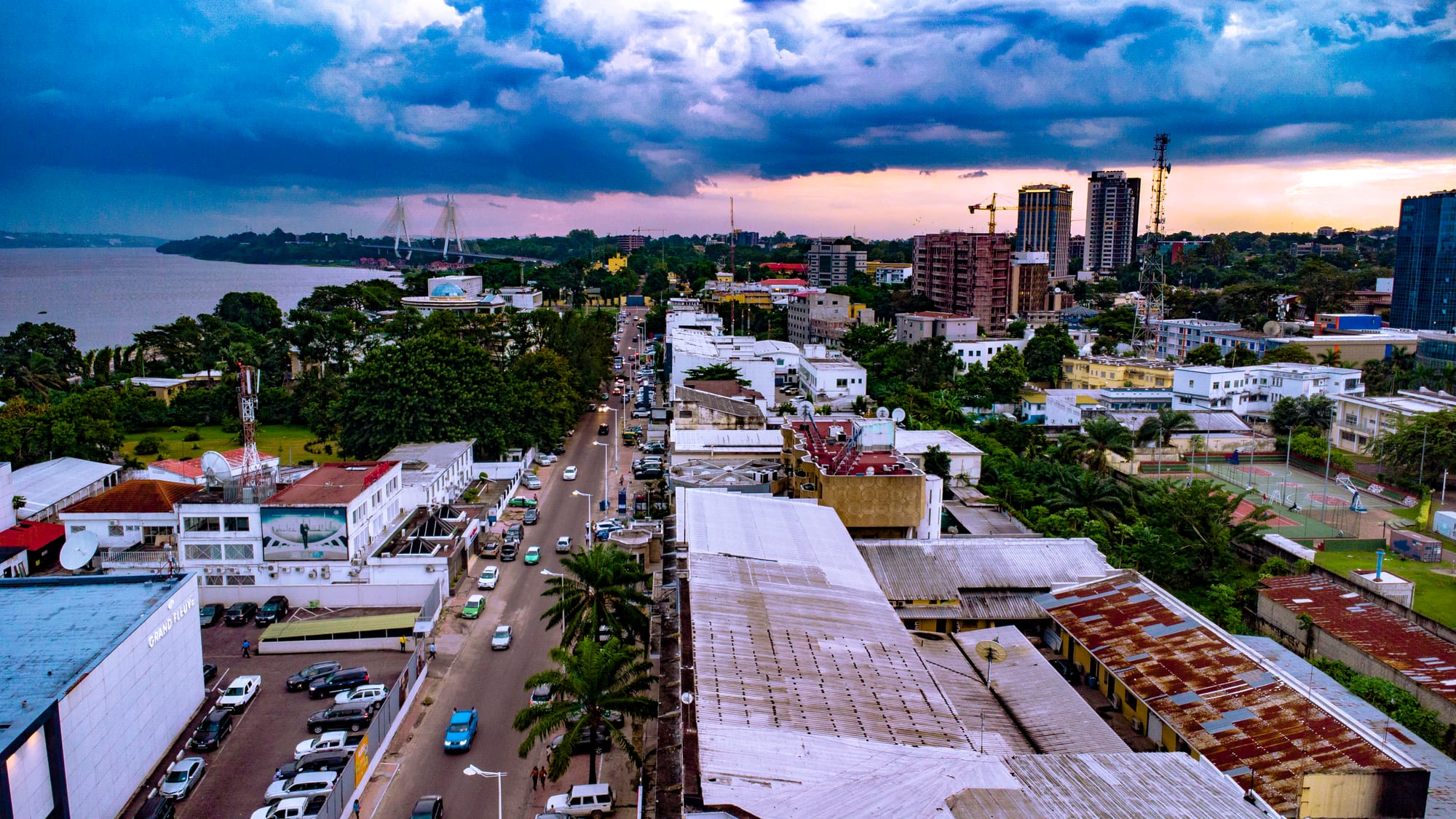
Aerial view along a Brazzaville avenue of low white buildings and palms, with tower blocks on the right and the Congo River on the left under storm clouds

Brazzaville, Pointe-Noire & the South, Republic of the Congo

Brazzaville

Central Brazzaville seen from the air along Avenue Amilcar Cabral. (Prével EPOTA / Wikimedia Commons · CC BY-SA 4.0)

The capital of the Republic of the Congo, on the north bank of the Congo River where it widens into Pool Malebo, directly opposite Kinshasa. Founded as a French post in 1880 and later the capital of French Equatorial Africa, it is a low, green city of ministries, riverside bars and music, with rapids breaking downstream of its south-western edge.

Neighbourhoods

  • Le Plateau and the centre
    • First-time visitors
    • Business
    • Close to transport

    The administrative heart above the river, with ministries, embassies, banks and most of the city's larger hotels. The Nabemba Tower stands here, and the riverside Corniche runs below it, looking across the water to Kinshasa.

    Open in Maps
  • Poto-Poto
    • Local life
    • Best for food
    • Music

    A dense, largely Lingala-speaking quarter north-east of the centre, laid out in the colonial period for African residents. It holds the painting school that carries its name, a large market and a long tradition of bars and live music.

    Open in Maps
  • Bacongo
    • Music
    • Nightlife
    • Local life

    The southern quarter on the way to the rapids, the heartland of the city's Lari and Kongo population. It is the district most associated with the sapeurs and with rumba bars, and its avenues fill with people in the evening.

    Open in Maps
  • Makélékélé
    • Quiet and residential
    • Walks near the rapids

    The city's south-western arrondissement, spreading towards the point where the Congo River breaks into rapids. It is mainly residential, with markets serving the surrounding streets and easy access to the riverbank west of Bacongo.

    Open in Maps
  • Moungali and Ouenzé
    • Markets
    • Local life
    • Nightlife

    Busy inland districts north of the centre, crossed by main avenues and filled with small shops, workshops, bars and market streets. They are among the most crowded parts of the city and are close to Maya-Maya airport.

    Open in Maps
  • Talangaï
    • Quiet and residential
    • Riverside

    The northern end of the city along the river, more spread out than the central districts and still growing outwards. Fishing and river trade are part of daily life here, and the built-up area thins into gardens and plots.

    Open in Maps

Things to do

Famous landmarks

  • Basilica of Sainte-Annelandmark

    The city's landmark church, designed by the architect Roger Erell, known for its tall pointed arches and green-tiled roof.

    Open in Maps
  • Nabemba Towerlandmark

    The curved office tower of 1986 above the Plateau, the tallest building in the country and a fixture of every view of the city from the river.

    Open in Maps
  • Sacred Heart Cathedrallandmark

    The Catholic cathedral of Brazzaville, built in 1892 and consecrated in 1894, and described as the oldest cathedral still standing in central Africa.

    Open in Maps
  • Brazza Memoriallandmark

    A white marble mausoleum on the Corniche, opened in 2006, where the remains of the city's founder and members of his family were reburied.

    Open in Maps
  • The Cornicheviewpoint

    The riverside boulevard below the Plateau, built as a promenade and the place to look across Pool Malebo to Kinshasa.

    Open in Maps

Museums and art

  • Poto-Poto School of Paintingmuseum

    An art school founded in 1951 that gave its name to a widely recognised Congolese painting style, with studios and a gallery in Poto-Poto.

    Open in Maps

The river and the rapids

  • Pool Maleboattraction

    The lake-like widening of the Congo River in front of the city, dotted with sandbanks and islands and worked by fishing pirogues.

    Open in Maps
  • Livingstone Fallsattraction

    The long series of rapids and cataracts that begins just below the city, where the river drops out of the Pool; the closest stretch is a weekend gathering place.

    Open in Maps

Getting about

  • Maya-Maya Airporttransit hub

    The international airport, unusually close to the centre of the city, with regular flights to Pointe-Noire and to destinations in Africa, Europe and the Middle East.

    Open in Maps
  • Stade Alphonse Massemba-Débatattraction

    One of the two grounds used by the national football team, alongside the stadium at Kintélé, and named after a former president.

    Open in Maps
  • Kintéléattraction

    A town in the north-eastern suburbs, joined to the city by a viaduct almost 7 km long, built up around the sports complex raised for the 2015 African Games and a university opened in 2021.

    Open in Maps

Short trips from the city

  • Lesio Louna Reservepark

    A reserve of about 440 km² north of the city, created in 1993 and dedicated to the protection of gorillas, in a landscape of grassland and gallery forest.

    Open in Maps
  • Kinshasaattraction

    The capital of the Democratic Republic of the Congo, visible across the water and reached by ferry; it is a separate country and needs its own visa.

    Open in Maps

Seasonal events

  • Pan-African Music Festival (FESPAM)held every two years, usually in July

    A continental music festival founded in 1996 and based in Brazzaville, with concerts, a market for African music and academic sessions.

  • Independence Day15 August

    The national holiday marking independence from France in 1960, marked by a military parade and public celebrations in the capital.

  • Dry-season river lifeJune to September

    The cooler, drier months when the Corniche, the riverside bars and the rapids at the city's edge are busiest at weekends.

Eat and drink

Long-standing places and food districts in Brazzaville. Hours, ratings and directions come from your maps app, always current.

Brazzaville classics

  • Grilled goat and fish along the Cornicheneighborhood

    Open-air grills above the river serve ntaba, skewered and grilled goat, and whole fish from the Congo, with grilled plantain and chilli sauce.

    Open in Maps
  • Saka-saka and chikwangue kitchensrestaurant

    Small local restaurants across the city serve pounded cassava leaves cooked with palm oil and smoked fish, alongside the leaf-wrapped cassava loaf called chikwangue.

    Open in Maps
  • Mabokérestaurant

    Fish or chicken seasoned and steamed in a parcel of banana or cassava leaves, a river-country dish found in eating houses throughout the capital.

    Open in Maps

Markets and food districts

  • Marché Totalmarket

    The main market of Bacongo and one of the largest in the city, selling cassava, plantain, smoked fish, safou and household goods.

    Open in Maps
  • Poto-Poto market streetsneighborhood

    Stalls and street kitchens through Poto-Poto, good for mikaté dough balls in the morning and grilled meat later in the day.

    Open in Maps
  • Bacongo barsneighborhood

    The district's rumba bars, where bottled lager and brochettes come with recorded and live music, and the sapeurs make their entrances.

    Open in Maps

Experience Brazzaville

History

Brazzaville dates from September 1880, when the French-naturalised Italian explorer Pierre Savorgnan de Brazza signed a treaty with the Teke ruler known as the Makoko and left a small post on the north bank of Pool Malebo. The site mattered because navigation on the Congo River ends here: below the Pool the water breaks into the rapids of the Livingstone Falls, so goods from the interior had to be unloaded and carried to the sea.

The settlement grew into the capital of French Equatorial Africa in 1910, governing a territory reaching to the Sahara. The Congo-Ocean Railway, built between 1921 and 1934 to link it to the new port of Pointe-Noire, cost the lives of many thousands of forced labourers. In 1940 Brazzaville became the capital of Free France in Africa, and in 1944 Charles de Gaulle convened the Brazzaville Conference here, which opened the way to reform of the French empire.

Independence came in 1960, and the city was the stage for the political struggles that followed: the 1963 uprising that removed the first president, the Marxist period after 1969, and the civil wars of 1993–94 and 1997–99, which were fought street by street through its southern districts and left large parts of Bacongo and Makélékélé ruined. Reconstruction since then has been uneven, with new ministries, roads and a corniche along the river alongside quarters that are still rebuilding.

Culture & Customs

Brazzaville shares a musical world with Kinshasa across the water. Congolese rumba, which UNESCO added to its intangible heritage lists in 2021, grew up in the bars of both cities in the mid-twentieth century and spread across Africa, and its later forms, soukous and ndombolo, are still the sound of the districts at night. The city hosts the Pan-African Music Festival, known as FESPAM, every two years, bringing musicians from across the continent.

The other export is a style. The sapeurs — members of the Société des Ambianceurs et des Personnes Élégantes — are men, and now some women, who spend heavily on tailored suits and parade them in the streets of Bacongo, treating elegance as a discipline and a form of dignity. Painting has its own local tradition: the Poto-Poto school, founded in 1951 by the French painter Pierre Lods, trained artists whose stylised, elongated figures became widely recognised abroad.

Religion is a strong presence, with Catholic and Protestant churches joined by revivalist congregations whose services fill Sunday mornings with singing. Greetings are long, elders are addressed with care, and football is followed closely, with the national side and the local clubs drawing crowds. French is the public language; Lingala carries the music, the street and the north of the city.

Daily Life

Brazzaville had 2.15 million residents at the 2023 census, more than a third of the country's population, and the city continues to draw migrants from the departments. Most work is informal: market trading, transport, workshops and construction, around a core of government employment in the ministries on the Plateau, the diplomatic missions and the river port. Oil money reaches the city as state salaries and public works rather than as industry, and unemployment among young people is high.

The districts differ sharply. The Plateau and the Corniche hold offices, banks and hotels; Poto-Poto, Moungali and Ouenzé are dense and commercial; Bacongo and Makélékélé stretch south towards the rapids; and Talangaï and Djiri spread north along the river, where new plots are still being built on. Power cuts and water shortages are common, and unpaved streets turn to mud in the rainy season, with erosion gullies a recurring problem on the sandy slopes.

Days start early. Markets are busy by seven, green-and-white shared taxis fill the avenues, and the heat empties the streets in the early afternoon. Evenings belong to the bars, the grills and television football, and weekends to church, family gatherings and the riverside.

Food

Cassava underpins the table, eaten as fufu or as chikwangue, the dense fermented loaf steamed in leaves and sold in markets in long parcels. Its leaves, pounded and simmered for hours with palm oil, onion and smoked fish, become saka-saka, the dish most often on the plate beside it. Plantain, ripe or green, is the other staple, fried, boiled or grilled.

Fish from the Congo and its tributaries is the everyday protein — fresh, smoked or salted, grilled over charcoal or cooked as maboké, wrapped in banana or cassava leaves and steamed so that it keeps its juices. Poulet moambé, chicken in a sauce of palm-fruit pulp with chilli, is the dish most often called national and is shared with the DR Congo. Ntaba, grilled goat cut into pieces and served with chilli, is the great street food of the evening, eaten at the grills along the Corniche and in the bars of Bacongo and Poto-Poto.

Mikaté, small fried dough balls, are a breakfast bought at the roadside, and safou, the purple fruit eaten roasted or boiled with salt, marks its season. Palm wine comes in from the villages, bottled lager is drunk everywhere, and ginger juice and bissap, made from hibiscus flowers, are the common soft drinks.

Planning tools

Budget

Brazzaville is expensive for what it offers. Hotels are priced for government, diplomatic and oil-sector visitors, and restaurants aimed at expatriates charge European prices, while local food, markets and shared taxis cost very little. Car hire with a driver is the usual way to move around and is a substantial daily cost.

Daily Budget Midrange
USD 160–310 (business-standard hotel, restaurant meals, hired car with driver)
Daily Budget Shoestring
USD 60–110 (simple hotel, market and street food, shared taxis)

Bring euros in cash to change, since cash machines are unreliable and cards are accepted only at larger hotels.

Best Time to Visit

June to September, the drier and cooler season, is the most comfortable time, with less mud, easier road travel and skies that are often overcast rather than stormy. The rainy months from October to May bring heavy afternoon downpours but leave the city and the plateau green.

Suggested Number of Days

Two days covers the city itself at an unhurried pace. Four or five suit anyone adding the plateau country north of the city or a crossing of the river. Heat, traffic and the distances between districts slow everything down.

First Visit
2 days
With Surroundings
4–5 days

Transportation

Shared taxis and minibuses, painted green and white, run fixed routes along the main avenues and are the way most people move; taxis can also be hired for a private journey by agreeing the fare first. Many visitors use a car and driver arranged through a hotel. Traffic on the main avenues is heavy in the morning and late afternoon, and unpaved side streets flood in the rains.

Agree any taxi fare before setting off, and allow extra time for checkpoints and traffic when heading to the airport.

Airport & Station Connections

Maya-Maya Airport lies close to the centre, with regular flights to Pointe-Noire and to destinations in Africa, Europe and the Middle East. The Congo-Ocean Railway to Pointe-Noire runs slowly and irregularly from the station in the centre, and buses and shared vehicles use the paved highway to the coast, a journey of the better part of a day. Ferries cross the river to Kinshasa.

Walkability

The Plateau and the Corniche are walkable, and the riverside is a pleasant stretch on foot in the cooler hours. Beyond the centre the city is spread out, pavements are broken or absent, and heat, traffic and afternoon rain make long walks unappealing; most journeys between districts are made by shared taxi.

Safety

Street crime is the main risk, above all after dark and around markets and transport hubs, where bag-snatching and pickpocketing occur. Police checkpoints are common and identity documents are asked for. Photography of government and military buildings and of the riverbank facing Kinshasa is prohibited. The Pool department west and south of the city saw fighting in 2016–2017 and a ceasefire has held since December 2017, but the area remains sensitive.

Use arranged transport at night, carry ID and the yellow fever certificate, do not photograph official buildings or the riverbank border area, and swim only where locals do. Check current official travel advice before travelling.

Climate

Hot and humid all year, close to the Equator, with a long rainy season from about October to May and a drier, cooler and often grey season from June to September. Temperatures vary little, generally between about 20°C and 33°C.

Summer
rainy season, hot and humid, around 25–33°C, with heavy afternoon thunderstorms
Winter
dry season from June to September, cloudy and milder, around 20–29°C, with little rain

Local Customs

French is the language of offices and business, with Lingala the everyday speech of the northern districts and Kituba common in the south. Greetings are unhurried and handshakes expected before any conversation turns to business. Dress is formal by regional standards, and elegance is taken seriously, above all in Bacongo. Churches are well attended and modest dress is appropriate for a service.

Ask before photographing people, never photograph soldiers, police, official buildings or the river frontier, and keep identity documents to hand for checkpoints.

Common Payment Methods

The currency is the Central African CFA franc (XAF), pegged to the euro. Cash rules: cards are accepted at a handful of hotels and supermarkets and almost nowhere else, and cash machines are limited and sometimes empty. Euros are the easiest currency to change, at banks and exchange offices in the centre.