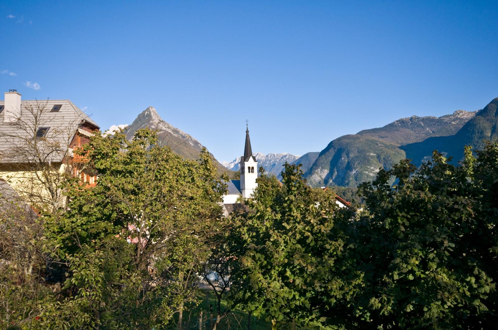
A white church spire rising above green trees and house roofs, with a pointed grey peak and forested mountains behind under a clear blue sky

The Coast, Karst & Soča Valley, Slovenia

Bovec

The church tower of Bovec below the peak of Svinjak and the mountains of the Julian Alps. (richd777 from Montreal, Canada / Wikimedia Commons · CC BY-SA 2.0)

A small town in the Bovec Basin of the upper Soča, below Mount Kanin and Rombon in the Julian Alps, close to the Italian border. Almost destroyed in the First World War battles of the Isonzo and shaken by earthquakes since, it now lives largely from rafting, kayaking, hiking and the mountains around it.

Neighbourhoods

  • The town centre
    • First-time visitors
    • Outdoor sports
    • Best for food

    The main square, Trg golobarskih žrtev, and the main street of two-storey town houses, rebuilt after the fire of 1903 and the First World War in the old local style. The parish church of St Ulrich stands above on its monumental staircase, and the rafting agencies, cafés and restaurants are all within a few minutes' walk.

    Open in Maps
  • Kaninska vas and the southern edge
    • Quiet and residential
    • Camping

    The apartment settlement of Kaninska vas and the quieter outer parts of town look out over the Bovec plain. To the south lie the campsite beside the 16th-century church of the Virgin Mary in Polje and a small sports airfield.

    Open in Maps
  • Log pod Mangartom and the Koritnica valley
    • Mountains
    • Quiet villages

    The Koritnica valley runs north from the basin past the Kluže gorge towards the Predel Pass. Log pod Mangartom, a village below Mangart, was badly changed by a landslide in 2000, and the road to the Mangart Saddle climbs from this side.

    Open in Maps

Things to do

The river and waterfalls

  • Sočapark

    The Alpine river rising in the Trenta Valley and flowing past Bovec towards the Adriatic, known for its white-water rafting and kayaking, with many agencies in town offering trips, canyoning and hydrospeed.

    Open in Maps
  • Boka waterfallviewpoint

    A waterfall from a karst spring just outside Bovec, falling 106 m in its upper stage and 33 m in its lower; a short trail leads from the main road to a viewing platform.

    Open in Maps
  • Virje waterfallviewpoint

    A waterfall about 20 m high in a wide hollow below the village of Plužna, on a stream fed by a karst spring, reached by a steep footpath.

    Open in Maps

First World War and older history

  • Kluže Fortresslandmark

    An Austrian fort of the late 19th century guarding the Koritnica gorge on the road to the Predil Pass, built on the site of a fortress of 1472 that Napoleon's troops took in 1797.

    Open in Maps
  • Fort Hermannlandmark

    An Austro-Hungarian fort built in 1897–1900 on Rombon, on the high ground above Kluže, heavily damaged by Italian artillery in 1915.

    Open in Maps
  • Austro-Hungarian military cemeterylandmark

    The war cemetery at the junction of the roads to the Predil and Vršič passes, where more than 600 Austro-Hungarian and Italian soldiers of the Isonzo Front are buried.

    Open in Maps
  • Church of the Virgin Mary in Poljelandmark

    A Gothic church of the 16th century beside the campsite, its exterior partly altered after the First World War; inside, only the frescoes on the left side of the chancel arch survive.

    Open in Maps

Short trips from the town

  • Trenta Valleypark

    The valley next to the Bovec Basin that leads into Triglav National Park, where the Soča rises.

    Open in Maps
  • Vršič Passviewpoint

    Slovenia's highest pass, at 1,611 m, crossing the Julian Alps from the Trenta Valley to Upper Carniola.

    Open in Maps
  • Mangart Saddleviewpoint

    A saddle at 2,072 m below Mount Mangart, reached by the Mangart Road, the highest-lying road in Slovenia.

    Open in Maps
  • Kobarid and its war museummuseum

    The town down the valley known to Italians as Caporetto, with a museum of the 1917 battle in its centre and the Italian ossuary on the hill above.

    Open in Maps

Eat and drink

Long-standing places and food districts in Bovec. Hours, ratings and directions come from your maps app, always current.

Bovec classics

  • Bovec cheesemarket

    Bovški sir, a hard sheep's cheese with protected geographical status from the Municipality of Bovec, the town's best-known product.

    Open in Maps
  • Frikarestaurant

    A traditional dish of the upper Soča, of Friulian origin, made with aged cheese — usually Tolminc — potatoes, eggs and lard, sometimes with pancetta.

    Open in Maps

Food districts

  • Trg golobarskih žrtevneighborhood

    The main square and street of Bovec, where several of the town's restaurants and grills stand, along with an outdoor-activity centre with its own kitchen.

    Open in Maps

Experience Bovec

History

People lived in the upper Soča valley long before Bovec was named. Late Stone Age tools have been found on the edge of town, the isolated hill of Ravelnik held a fortified settlement in the Hallstatt period, and a Roman road from Aquileia ran through the basin towards the Predil Pass, with a Roman country villa near today's church of the Virgin Mary in Polje. Written sources record the name from 1070, and the town itself from the late 12th century, when it belonged to the Patriarchs of Aquileia. It passed to Venice in 1420 and to the Habsburgs in 1509, staying, apart from the Napoleonic years, in the County of Gorizia until 1918. A fortress was built at the Kluže gorge in 1472; Napoleon's troops captured it in 1797.

Part of the town burned in 1903, and the First World War then almost erased it. From June 1915 to November 1917 the battles of the Isonzo were fought between the Austro-Hungarian and Italian armies across Rombon, the Bovec Basin and the Krn mountains, leaving forts, trenches and cemeteries that the Peace Trail (Pot miru) now links. After the war Bovec was given to Italy by the 1920 Treaty of Rapallo, and under Fascist rule its Slovene population faced forced Italianisation; many joined the anti-fascist TIGR organisation or emigrated to Yugoslavia.

After the Second World War the town lay in the Allied-run Zone A until the Paris Peace Treaties gave it to Yugoslavia in 1947, and it became a town in 1951. Earthquakes struck in 1976, 1998 and 2004, and in 2000 a landslide devastated Log pod Mangartom. Since 1991 Bovec has been part of independent Slovenia.

Culture & Customs

Bovec's culture is shaped by the mountains and the war. Its rebuilt main street is lined with two-storey town houses in the local Bovec style, and the local speech, Bovec dialect, was added to Slovenia's register of intangible cultural heritage in 2021. Locals traditionally belonged to the Goriška region but today prefer to identify with the wider Slovene Littoral.

The front line of the First World War runs through the whole landscape. The military cemetery east of town holds more than 600 Austro-Hungarian and Italian soldiers, the Kluže fort and Fort Hermann guard the road north, and the Peace Trail ties the remains together with the museums and memorials down the valley at Kobarid.

The town also has a modern outdoor identity. Rafting and kayaking companies, paragliding, hiking routes such as the Soča Trail and the Alpe-Adria Trail, and cheese tasting on the Mangart plain draw visitors from across Europe, and the valley's scenery has attracted filmmakers, including the makers of The Chronicles of Narnia: Prince Caspian, part of which was shot here. In 2008 the area received a European Destinations of Excellence award for its Soča Stories project.

Daily Life

About 1,500 people lived in Bovec in 2025, making it the centre of the Municipality of Bovec. The town sits at about 434 m on the highest river terrace of the Bovec Basin, under the southern slopes of Rombon, with the Soča flowing in from the east and the Koritnica from the north.

Many residents work in tourism, though industry remains a main source of income, with the metalworking firm Letrika among the employers. The town has several hotels and guesthouses, a campsite and a sports airfield. A circular cable car up Kanin, built in 1973 and renovated at the end of 2016, has not run since 2023.

The rhythm of the year follows the river and the weather. Summer fills the town with rafting groups, kayakers, hikers and campers, while winter is quiet. Natural hazards are a constant theme of local life: earthquakes and landslides have repeatedly damaged the town and its villages.

Food

The best-known local product is Bovec cheese, bovški sir, a hard sheep's cheese with protected geographical status made in the Municipality of Bovec. The Bovec sheep, a local breed of the upper Soča valley named after the town and raised for both milk and meat, is called trentarka in the Trenta valley. Tolminc, a cows'-milk cheese with protected status, is made in the Tolmin area.

Frika is the dish of the upper Soča. It came from neighbouring Friuli and is made in many versions, but its main ingredients are aged cheese, usually Tolminc, potatoes, eggs and lard, sometimes with pieces of meat such as pancetta. Cheese tasting on the Mangart plain is one of the area's attractions.

Eating out centres on the main square and street, where restaurants serve pizza and pasta, grills and burgers, and an outdoor-activity centre runs its own kitchen with breakfast and brunch, aimed at the visitors who fill the town in summer.

Planning tools

Budget

Bovec is an outdoor-sports town, and guided rafting, kayaking, canyoning and paragliding trips are the main expense after rooms. The town has several hotels and guesthouses and a campsite, and July and August are the busiest months on the river.

Daily Budget Midrange
USD 130–260 (guesthouse or apartment, restaurant dinners, a guided river trip, a hire car)
Daily Budget Shoestring
USD 60–95 (campsite or hostel bed, self-catering and simple meals, buses)

Several agencies give discounts for booking more than one activity with them.

Best Time to Visit

Late spring to early autumn is the season for rafting, kayaking, hiking and the high mountain roads; July and August are the busiest months. The Vršič and Mangart roads are high-altitude routes, and in winter the town is very quiet.

Suggested Number of Days

Two or three days suit a first visit to the town and the river. Allow longer for several guided outdoor trips, the high mountain roads and the neighbouring valleys; time on the water depends on the weather and the river's level.

First Visit
2–3 days
With Surroundings
4–6 days

Transportation

The town itself is small and walkable. Beyond it a car makes the valleys, passes and waterfalls much easier to reach; buses are infrequent. Bicycles can be hired, and there are many mountain-bike and hiking trails.

The Vršič and Mangart roads are high mountain routes with many hairpin bends.

Airport & Station Connections

Bovec is about 136 km from Ljubljana. Buses from the capital take around three and a half hours; by train, the nearest station is Most na Soči, about 40 km away by bus. Drivers arrive from Italy and Austria over the Predel Pass, from Kranjska Gora over the Vršič Pass, or up the valley from Nova Gorica, Tolmin and Kobarid. International flights land at Ljubljana Airport at Brnik.

Walkability

The centre can be crossed on foot in minutes, and Boka waterfall, the Kluže fort and the river are reachable by trail or a short drive. The Peace Trail footpath links Bovec with Kluže Fortress.

Safety

Slovenia is one of the safest countries in Europe, with low crime. Bovec is a quiet town, and the main hazards are natural ones: cold water and rapids on the Soča, fast-changing mountain weather, and earthquakes, which have damaged the town several times.

Raft and kayak only with licensed operators and with a wetsuit and helmet. Check current official travel advice before travelling.

Climate

The town lies in the Julian Alps close to the Italian border, and the weather in the mountains around it changes quickly.

Summer
in nearby Tarvisio, across the Predil Pass in Italy, summers are quite warm, with a record high of 37°C in July 1983
Winter
in nearby Tarvisio, winters are cold and very snowy, with about 250 cm of snow a year and a record low of −23°C in January 1985

Local Customs

The local Bovec dialect, entered on Slovenia's register of intangible cultural heritage in 2021, is still spoken. A greeting on entering a shop or guesthouse is normal, and English is widely spoken by outdoor guides. War cemeteries and memorials in the valley are places of remembrance.

Behave quietly at the war cemeteries and memorials, and keep to marked trails around the old front lines.

Common Payment Methods

Slovenia uses the euro. Cards are accepted almost everywhere; keep some small cash for parking, mountain huts and rural stalls.