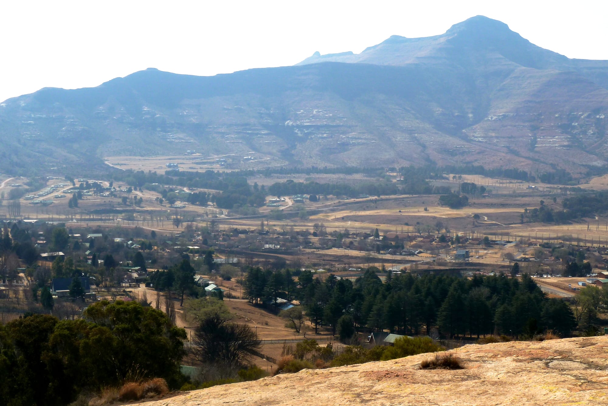
A village of small houses and dark conifers spread across a valley floor beneath a long brown mountain ridge

The Free State & North West, South Africa

Clarens

Clarens below Mount Horeb in the Rooiberge range, eastern Free State. (JMK / Wikimedia Commons · CC BY-SA 3.0)

A small village in the eastern Free State, set among sandstone cliffs in the foothills of the Maluti Mountains near the Lesotho border. Laid out in 1912 and named after the Swiss town where Paul Kruger died, it was a farming settlement until artists and weekend visitors from Gauteng turned it into a place of galleries, guesthouses and mountain walks below the Golden Gate Highlands National Park.

Neighbourhoods

  • The village square
    • First-time visitors
    • Art galleries
    • Best for food

    Clarens is arranged around a green square lined with sandstone shopfronts holding galleries, craft shops, pubs, coffee shops and restaurants. Almost everything a visitor does happens within two or three blocks of it, and the whole centre is walkable.

    Open in Maps
  • The guesthouse streets
    • Quiet
    • Views
    • Weekend stays

    Behind the square, low streets of sandstone and plastered houses with gardens spread towards the edge of the village, most of them holding guesthouses and self-catering cottages. Cliffs and mountain ridges close the view at the end of nearly every road.

    Open in Maps
  • Kgubetswana
    • Local life

    The township immediately adjoining the village on its southern side, home to much of the working population, with small shops, taverns and a school. It grew during the apartheid years and remains where most of Clarens' residents actually live.

    Open in Maps
  • The farm and cliff edge
    • Walks
    • Horse riding
    • Wildlife

    Beyond the last houses, the commonage and surrounding farms run up to sandstone outcrops and grassland used for walking, riding and mountain biking, with the Maluti foothills and the road to the national park beyond.

    Open in Maps

Things to do

In the village

  • The galleries around the squareattraction

    A concentration of art and craft galleries unusual for a village of this size, selling painting, sculpture, ceramics and beadwork by artists who live in the district.

    Open in Maps

Mountains and parks

  • Golden Gate Highlands National Parkpark

    The Free State's only national park, proclaimed in 1963, known for deeply eroded ochre sandstone cliffs such as the Brandwag rock, San rock paintings, eland and zebra, and dinosaur fossil finds.

    Open in Maps
  • QwaQwa National Parkpark

    The mountainous eastern section of the Golden Gate park, taking in the highlands of the former QwaQwa homeland, with high grassland walks towards the Lesotho escarpment.

    Open in Maps
  • Clarens Nature Reservetrail

    The commonage of cliffs and grassland ringing the village, crossed by walking and mountain-bike trails, including the sandstone outcrop known locally as Titanic Rock.

    Open in Maps

Short trips from the village

  • Bethlehemattraction

    The nearest sizeable town, about 35 kilometres north-west in the wheat country, with the district's hospitals, shops and airfield.

    Open in Maps
  • Ficksburgattraction

    A sandstone town on the Mohokare river opposite Lesotho, the centre of South African cherry growing and the home of the Cherry Festival.

    Open in Maps

Seasonal events

  • Clarens Craft Beer FestivalFebruary or March

    A craft-beer festival on the village square, founded in 2011, bringing South African breweries, food stalls and live music to Clarens.

  • Ficksburg Cherry FestivalNovember

    A festival in the nearby cherry-growing town, held when the orchards of the eastern Free State come into fruit, with markets, orchard tours and processions.

Eat and drink

Long-standing places and food districts in Clarens. Hours, ratings and directions come from your maps app, always current.

Around the square

  • The square's restaurants and pubsneighborhood

    The sandstone buildings around the green hold steakhouses, pizzerias, pub kitchens and coffee shops, busy with weekend visitors from Gauteng and quiet midweek.

    Open in Maps
  • Craft beer and breweriesneighborhood

    Clarens has become associated with small-batch beer, and brewing taprooms in and around the village serve their own ales alongside pub food.

    Open in Maps

The country table

  • Braai, lamb and venisonrestaurant

    Free State cooking centres on meat over coals — boerewors sausage, lamb from the highland farms and farmed venison, usually with pap, the stiff maize porridge, or potatoes.

    Open in Maps
  • Cherries, asparagus and farm producemarket

    Farm shops and stalls sell cherries and cherry jam from the Ficksburg district in season, asparagus, cheeses, preserves and bread baked in wood ovens.

    Open in Maps

Experience Clarens

History

The sandstone country around Clarens was long used by San hunter-gatherers, whose paintings survive in shelters in the cliffs of the surrounding hills and in the national park nearby, and later by Basotho communities farming and herding in the foothills of the Malutis. The Caledon, or Mohokare, valley to the south became the frontier between the Basotho kingdom of Moshoeshoe and the Orange Free State republic, and the wars of 1858 to 1868 transferred much of the fertile land west of the river to the republic, opening the district to Boer farms.

The village itself is young. It was laid out in 1912 on two farms and named after Clarens in Switzerland, the lakeside town where Paul Kruger, president of the South African Republic, died in exile in 1904. For its first decades it was an ordinary service centre for maize, wheat and sheep farmers, with a church, a few stores and the sandstone buildings that give the place its character. The surrounding highlands were declared a national park at Golden Gate in 1963, and during the apartheid era the small Basotho homeland of QwaQwa lay immediately to the east, its land later incorporated into the park.

Clarens changed in the last quarter of the twentieth century, when artists moved in and the village's setting, cheap sandstone houses and clear light made it a weekend destination for Gauteng, three and a half hours away. Galleries, guest houses, restaurants and small breweries followed, and tourism overtook farming as the main business. The Lesotho Highlands Water Project, completed in stages from the 1990s, added another presence nearby: water tunnelled from Lesotho emerges at an outfall on the Ash River near the village and flows on towards the Vaal.

Culture & Customs

For a village of its size Clarens has an unusual concentration of artists, and the galleries around the square — landscape painting, sculpture, ceramics, beadwork and craft — are the reason many people come. The sandstone architecture, the poplars and the mountain backdrop have been painted and photographed so often that the village has a settled visual identity, and the local art economy supports framers, potters and craft workshops alongside the galleries.

The wider district is Sesotho-speaking, and Basotho culture is strong on both sides of the nearby border: the patterned woollen blanket worn as a cloak against the highland cold, the conical mokorotlo hat, horses as everyday transport in the mountains, and choral and traditional music at gatherings. Afrikaans farming culture runs alongside it, with Dutch Reformed churches, agricultural shows and rugby, and the two meet in the village's shops and workplaces.

Weekends set the social calendar. From Friday the village fills with visitors from Johannesburg and Pretoria, the pubs and restaurants around the square are busy, and craft beer, mountain biking, trail running, horse riding and white-water paddling on the mountain rivers are the activities on offer; by Monday it is quiet again. Autumn colour and the first snow on the Malutis are local events in themselves, and residents are used to being asked for directions to the park.

Daily Life

Only a few thousand people live in Clarens and its township of Kgubetswana, which holds most of the population, within the Dihlabeng municipality centred on Bethlehem. The village proper is small and low-built, its streets laid out on the valley floor, and the difference between the guesthouse streets and the township is the same inequality visible across the country, at village scale.

Tourism is the main employer — guesthouses, restaurants, galleries, guiding and building work on the steady stream of new cottages — with farming the other mainstay: maize, wheat, sunflowers, sheep and cattle, and cherries and asparagus in the district to the south. Many households depend on seasonal and weekend work, wages are low, and people commute to Bethlehem or further for jobs, schooling and hospital care. Property prices in the village have risen sharply with its popularity, which pushes newer housing to the edges.

The rhythm is weekly rather than daily: a quiet Monday-to-Thursday of deliveries, building and farm business, then a busy weekend. Water supply, electricity interruptions, road maintenance and municipal finances are the recurring complaints, and winter brings burst pipes and frozen mornings. The proximity of Lesotho shapes daily life too, with cross-border trade, labour and family ties running through the district.

Food

Clarens eats like the Free State platteland with a weekend-visitor overlay. The braai is the centre of home cooking — boerewors, the coiled spiced sausage, lamb chops from the highland farms, and steak over coals — while restaurants around the square serve grills, burgers, pizza and trout, with farmed venison such as springbok and kudu on many menus. Potjiekos, meat and vegetables layered in a three-legged iron pot over a fire, suits the cold months, as does oxtail stew.

Sesotho cooking is the everyday food of the district: pap, the stiff maize porridge, eaten with a meat or vegetable stew and with moroho, cooked greens; motoho, a fermented sorghum porridge drunk at breakfast; and seswaa-style boiled and shredded meat at celebrations. Vetkoek, fried dough filled with mince, and grilled maize cobs are sold from stalls and roadside braziers.

The area's produce shapes the sweet side. Cherries from the Ficksburg orchards appear as fruit, jam and liqueur in season, asparagus comes from the same district in spring, and farm shops sell cheeses, preserves and wood-oven bread. Afrikaans baking is everywhere — koeksisters, syrup-soaked and plaited, milk tart, and malva pudding — and the village is known for small-batch beer brewed locally, drunk alongside Cape wine and rooibos tea.

Planning tools

Budget

Clarens is inexpensive by South African tourist standards, though rates in the guesthouses rise for weekends and school holidays when Gauteng empties into the eastern Free State. Meals, beer and gallery browsing cost little; the national park charges a daily conservation fee, and chalets inside it are good value. A car is the main fixed cost.

Daily Budget Midrange
USD 90–180 (village guesthouse or park chalet, restaurant meals, hire car, park fees)
Daily Budget Shoestring
USD 35–60 (backpacker bed or campsite, self-catering, shared car, park day fee)

Come midweek for lower rates and a quieter village, and buy the park's day permit rather than staying inside if the budget is tight.

Best Time to Visit

Autumn, from March to May, is the classic season: poplars and willows turn gold, the air is clear and the light on the sandstone is at its best. Summer, from November to February, is green and warm with afternoon thunderstorms. Winter is cold, dry and sunny, with frost most nights and occasional snow on the Malutis, and it fills the village with fireplaces.

Suggested Number of Days

A night or two suits the village itself, its galleries and a walk on the commonage. Three or four allow the national park, longer hikes and the sandstone towns nearby. Weekends are much busier than midweek, which affects how long everything takes.

First Visit
1–2 days
With Surroundings
3–4 days

Transportation

A car is needed to reach Clarens and to see anything beyond the village; there is no scheduled visitor transport, though minibus taxis connect Kgubetswana, Bethlehem and the surrounding towns for residents. The village itself is walked, and horses, bicycles and guided drives cover the farm and reserve tracks.

Fill up in Bethlehem or Clarens before long drives, watch for potholes, livestock and frost on the mountain roads in winter, and avoid driving these routes after dark.

Airport & Station Connections

Clarens is roughly three and a half hours by road from Johannesburg through Bethlehem, and a similar drive from Bloemfontein. The nearest scheduled flights are at Bloemfontein, with Johannesburg's OR Tambo the usual arrival airport for visitors from abroad. The Caledonspoort border post into Lesotho lies south beyond Fouriesburg, itself about half an hour's drive away.

Walkability

The village is one of the most walkable places in the country: the square, the galleries, the restaurants and most guesthouses are within a few hundred metres of each other on flat ground. Trails lead straight out of the village onto the commonage. Kgubetswana and the park, however, need a vehicle, and winter mornings are icy.

Safety

Clarens is a quiet village and sees far fewer problems than South Africa's cities, with the main risks being petty theft from cars and houses and the hazards of the outdoors: sudden weather changes, cold, and unfenced cliff edges on the walking trails. Mountain roads are best driven in daylight, and hikers should tell someone their route before leaving.

Stay in the vehicle in the game reserves, drive in daylight, and avoid demonstrations in mining towns. Check current official travel advice before travelling.

Climate

High and continental, in the foothills of the Malutis, which makes Clarens cooler than most of the country. Summer runs from December to February and brings the rain in afternoon thunderstorms; winter is dry, sunny and cold, with heavy frost and occasional snow on the surrounding peaks.

Summer
warm days around 24–28°C with cool evenings and frequent afternoon thunderstorms
Winter
sunny and dry, around 14–17°C by day, with nights below freezing and snow on the mountains

Local Customs

Sesotho is the main language of the district, with Afrikaans and English widely spoken in the village; greetings before conversation are expected and appreciated. Tipping runs at about ten per cent in restaurants, with small change for car guards. Basotho blankets and conical straw hats are everyday winter wear here rather than costume. Dress warmly: evenings are cold for most of the year.

Ask before photographing people, houses or livestock, close farm gates behind on walking routes, and treat rock-art sites in the park as protected, without touching or wetting the paintings.

Common Payment Methods

The currency is the South African rand. Cards are taken in the village's shops, galleries, restaurants and guesthouses and at the national park, and there are ATMs on the square. Cash is worth having for craft sellers, farm stalls, parking attendants and the occasions when power interruptions stop card machines working.