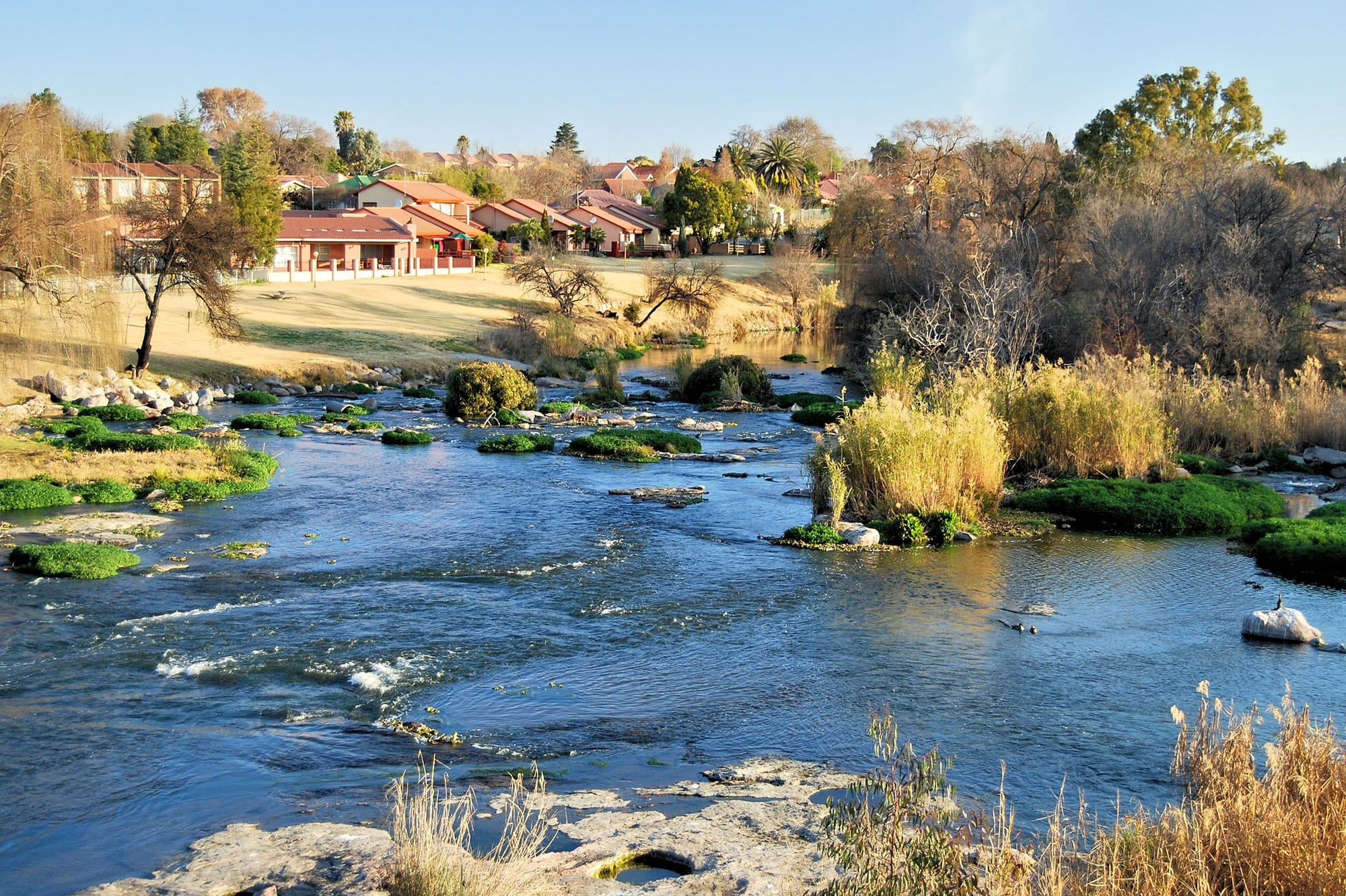
A wide shallow river running over rocks and green reed islands past houses and bare winter trees on the bank

The Free State & North West, South Africa

Parys

The Vaal River running past the West End of Parys, seen downstream from the road bridge. (Ossewa / Wikimedia Commons · CC BY-SA 4.0)

A small Free State town on the Vaal River, founded in 1876 and named after Paris by a German surveyor who saw a likeness in the river setting. It sits inside the eroded Vredefort Dome, the remains of an ancient meteorite impact, and has grown into a weekend destination of antique shops, galleries, river rafting and guesthouses.

Neighbourhoods

  • The town centre
    • First-time visitors
    • Antiques and galleries
    • Best for food

    A few blocks of low verandahed shopfronts around the main street, given over to antique dealers, second-hand book and furniture shops, craft galleries, coffee shops and restaurants. It is busiest at weekends, when visitors come out from Gauteng, and quiet during the week.

    Open in Maps
  • The riverfront and West End
    • Quiet and residential
    • River walks
    • Rafting

    Streets of older houses, guesthouses and lodges along the Vaal, facing the rocky channels and wooded islands that split the river here. Rafting and canoeing operators launch from this stretch, and the weir and road bridge give the best views of the water.

    Open in Maps
  • Tumahole
    • Local life

    The township west of the centre, home to most of the area's population, with its own shops, churches, schools and taverns. It grew from the labour settlement attached to the town and remains the main residential area of Parys.

    Open in Maps
  • The surrounding Dome countryside
    • Farm stays
    • Walks and cycling

    Hills, granite outcrops and river farms spread out from the town across the eroded ring of the Vredefort structure. Guest farms, mountain-bike trails and hiking routes lie a short drive from the centre along gravel roads.

    Open in Maps

Things to do

In and around the town

  • The Vaal Riverattraction

    The river that gives the town its setting, braiding here into rocky channels and reed islands, used for rafting, canoeing, fishing and birdwatching along the banks.

    Open in Maps

Short trips from the town

  • Vredefort Domeattraction

    The eroded central uplift of a meteorite impact structure roughly two billion years old, inscribed as a UNESCO World Heritage Site in 2005, whose ring of hills surrounds the town.

    Open in Maps
  • Vredefortattraction

    The small farming town about 15 km south that gave the impact structure its name, with a church square, a few old buildings and a quiet main street.

    Open in Maps
  • Sasolburgattraction

    An industrial town about 40 km east, built from 1954 around Sasol's coal-to-liquid fuel plants, and a study in mid-century planned-town design.

    Open in Maps
  • Potchefstroomattraction

    One of the oldest towns of the interior, founded in 1838, with Voortrekker-era churches, a museum and a large university campus.

    Open in Maps

Eat and drink

Long-standing places and food districts in Parys. Hours, ratings and directions come from your maps app, always current.

Where to eat

  • The main street and town centreneighborhood

    The main street and its side roads hold most of the town's restaurants, coffee shops and bakeries, several in old houses with verandahs and gardens, serving breakfasts, steaks, burgers and cake to weekend visitors.

    Open in Maps
  • Riverside restaurantsneighborhood

    Places set on or near the Vaal where the tables face the water, grilled meat and fish are the standards, and the river traffic of rafts and canoes passes below.

    Open in Maps
  • Farm stalls around the Domemarket

    Roadside stalls on the routes out of town sell biltong, droëwors, preserves, rusks, farm cheese and fresh produce from the surrounding farms.

    Open in Maps

Experience Parys

History

The land around Parys lies inside the Vredefort Dome, the eroded centre of a meteorite impact structure formed roughly two billion years ago, which pushed ancient granite up through the younger rock and left the ring of hills that frames the town. Long before European settlement the area was used by San hunter-gatherers and later by Tswana and Sotho communities farming and herding along the Vaal.

The town itself was laid out in 1876 on the farm Klipspruit, on the southern bank of the river, and named Parys after the French capital — the name is credited to a German surveyor, Schilbach, who thought the river and its setting resembled the Seine at Paris. It grew as a river crossing and a service centre for the surrounding maize and cattle farms of the Orange Free State republic, with a Dutch Reformed church, a market square and a wide grid of streets.

During the South African War of 1899–1902 the Vaal marked the boundary between the two Boer republics, the Orange Free State to the south and the South African Republic to the north. In the 20th century Parys remained a farming town, with the township of Tumahole growing to the west under segregation and becoming a centre of protest in the 1980s. From the 1990s the town was remade by weekend visitors from Gauteng: dealers opened antique and craft shops in the old buildings of the centre, rafting companies set up on the river, and guesthouses spread along the banks. The inscription of the Vredefort Dome as a UNESCO World Heritage Site in 2005 added a second reason to come.

Culture & Customs

Parys has the doubled character of a working Free State farming town and a weekend arts-and-antiques destination. From Monday to Thursday it runs on the rhythms of the district — the co-operative, the church, the school, the farm deliveries — and on Friday afternoon the traffic from Gauteng arrives and the restaurants and galleries fill.

Afrikaans is the dominant language in the town and Sesotho and Setswana in Tumahole, with English used in the shops and guesthouses that cater to visitors. The dealer and gallery culture is unusual for a town of this size: secondhand furniture, old farm implements, books, glassware and local painting and ceramics fill shops that in most Free State towns would be hardware stores, and many artists and retired city people have moved here.

The river shapes leisure. Rafting, tubing, canoeing and fly fishing are the local sports, alongside mountain biking and trail running on the Dome's hills, and the annual river races and cycling events draw entrants from the cities. Braai culture is strong, and weekends turn on fires, sport on the radio or television, and long lunches. Church life is central for many residents, both the Dutch Reformed congregations in town and the independent and Zionist churches in Tumahole. Visitors are received easily, but the town is protective of its quiet and of the river frontage, and debates about development along the banks are a regular feature of local politics.

Daily Life

Parys itself is a small town, and the township of Tumahole beside it is considerably larger. The economy rests on three things: agriculture in the surrounding district, mostly maize, sunflowers and cattle; tourism and hospitality, which employ a growing share of the town; and the services — schools, clinics, shops and municipal offices — that serve the wider area.

Working life divides along familiar South African lines. Many Tumahole residents commute into the town or to Sasolburg and Vanderbijlpark for industrial work, while the centre's businesses are largely small and family-run. Property prices along the river have risen with the weekend trade, and a steady trickle of people from Johannesburg and Pretoria have settled here to work remotely or retire.

The daily rhythm is early and unhurried: shops open in the morning and many close in the middle of the afternoon, especially on Sundays. Water supply, road maintenance, refuse collection and municipal debt are recurring local grievances, as they are across the province, and power cuts have shaped household routines for years. Winter mornings bring frost to the riverbank and mist over the water, and the town's pace slows further until the spring.

Food

Eating in Parys is country cooking with a weekend-visitor gloss. The braai underpins everything: boerewors, lamb chops and steak over coals, with pap, the stiff maize porridge, and chakalaka, a spiced tomato-and-onion relish, alongside. Potjiekos, a stew of meat and vegetables layered in a three-legged iron pot and left over the fire for hours, is the dish for a gathering, and potbrood, bread baked in the same kind of pot, comes with it.

The restaurants along the main street and the river run to large breakfasts, steaks, burgers and baked goods, with milk tart, koeksisters — plaited doughnuts soaked in syrup — and buttermilk rusks for dipping in coffee on the sweet side. Sesotho and Setswana households in Tumahole cook pap with beef or chicken stew, morogo, wild greens gathered and cooked with onion, and motoho, a thin fermented sorghum porridge. Vetkoek, fried dough split and filled with curried mince, is the common street food.

Farm stalls on the roads out of town are the place for biltong and droëwors, the dried spiced beef and sausage that South Africans eat as a snack, along with dried fruit, preserves, honey and farm cheese. Craft beer is brewed in the district, and the wine lists draw on the Cape. Fresh produce from the river farms — maize, pumpkins, peaches and pecans in season — reaches the stalls and the Saturday tables.

Planning tools

Budget

Parys is inexpensive by South African weekend-destination standards, though guesthouse rates rise on Fridays and Saturdays when visitors arrive from Johannesburg and Pretoria. Meals, coffee and river activities are cheap, and self-catering cottages and farm stays are common. A car is the main fixed cost.

Daily Budget Midrange
USD 110–220 (river guesthouse or guest farm, restaurant meals, car hire, a rafting trip)
Daily Budget Shoestring
USD 40–70 (campsite or self-catering cottage, self-catering meals, shared car)

Weekday visits are cheaper and quieter; book ahead for long weekends and school holidays, when the town fills.

Best Time to Visit

The warm months from October to April suit river activities, with the Vaal at its fullest after the summer rains and afternoon thunderstorms common. Autumn in April and May brings clear skies and colour along the river. Winter days are sunny and mild but nights are cold, and the water is bracing.

Suggested Number of Days

A night or two is enough for the town itself and a spell on the river. Add a day for the surrounding Dome countryside, the gravel roads and the nearby towns. Many visitors come for a weekend from Gauteng.

First Visit
1–2 days
With Surroundings
2–3 days

Transportation

Parys is a driving town. The centre is small enough to cover on foot, but the guest farms, trailheads and river launch points are spread along gravel roads outside it, and there is no visitor-oriented public transport. Minibus taxis link the town with Tumahole, Vredefort and the larger towns nearby.

Gravel roads around the Dome are passable in an ordinary car in dry weather but can be rough after rain; drive slowly and watch for livestock.

Airport & Station Connections

Most arrivals drive. Johannesburg is about 120 km north-east, roughly an hour and a half on the N1 and the R59, and Pretoria a little further; Bloemfontein is around three hours south. The nearest large airports are those of Johannesburg. Long-distance coaches use the N1 corridor rather than the town itself, so a car or a transfer is needed for the last stretch.

Walkability

The centre is flat, compact and pleasant on foot, with the antique shops, galleries and restaurants in a handful of blocks and the river a short walk away. Everything beyond that — the farms, the trails, the neighbouring towns — needs a vehicle, and there are few pavements on the outlying roads.

Safety

Parys is a quiet country town with far less crime than South Africa's cities, and the centre and riverfront are routine by day and in the evening. The practical risks are on the water and the roads: the Vaal has strong currents and rocky sections, and gravel roads, livestock and unlit stretches make night driving unwise.

Stay in the vehicle in the game reserves, drive in daylight, and avoid demonstrations in mining towns. Use a licensed rafting operator with life jackets, keep valuables out of sight in a parked car, and do not swim in the river alone. Check current official travel advice before travelling.

Climate

A highveld climate of hot, stormy summers and cold, dry, sunny winters, high on the interior plateau. Rain falls between November and March, mostly in afternoon thunderstorms. In the southern hemisphere summer runs from December to February and winter from June to August.

Summer
hot, 28–33°C by day, with afternoon thunderstorms and warm evenings
Winter
clear and dry, 17–20°C by day, with frost and near-freezing nights

Local Customs

Afrikaans is the most widely heard language in the town, with Sesotho and Setswana common in Tumahole and English understood almost everywhere. Dress is casual and small-town manners are friendly: greetings before business, and a wave to passing drivers on the farm roads. Church and sport shape Sunday. Ask before photographing people or private property.

Tipping is about 10 per cent in restaurants, with a few rand for car guards and petrol attendants, who fill the tank as a matter of course.

Common Payment Methods

The currency is the South African rand. Cards are accepted in restaurants, shops and fuel stations, and there are ATMs in the centre, but antique dealers, craft sellers, farm stalls and some river operators prefer cash, so it is worth carrying notes.