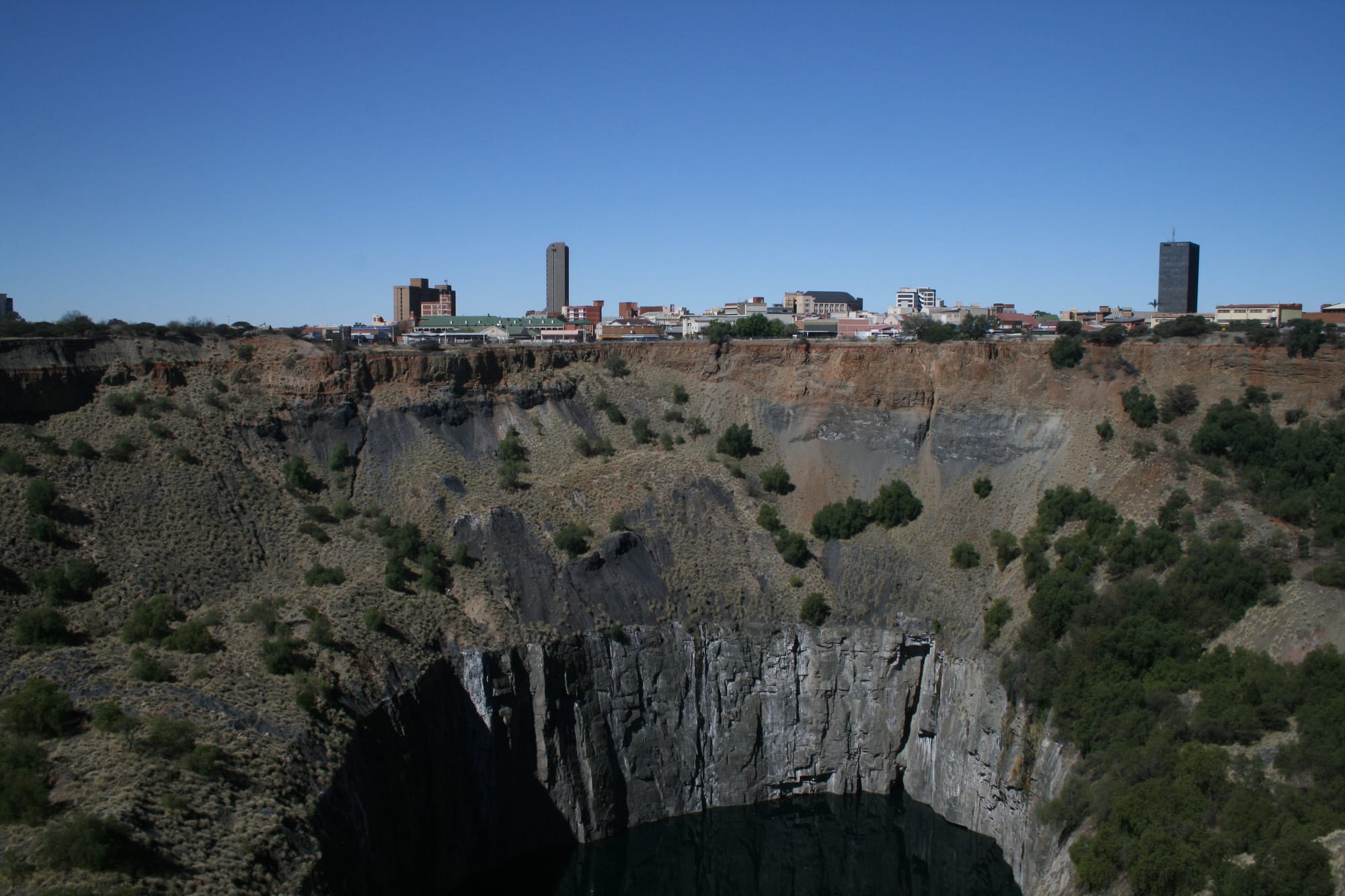
A deep rock-walled open pit with green scrub on its slopes, and a low city skyline of towers along the far rim

The Northern Cape & the Kalahari, South Africa

Kimberley

The Big Hole with the skyline of central Kimberley beyond it. (NJR ZA / Wikimedia Commons · CC BY-SA 3.0)

The capital of the Northern Cape, grown from the diamond rush that began in 1871 when prospectors swarmed a low hill on the dry plains and dug out the pit now known as the Big Hole. Diamonds made it one of the richest and most cosmopolitan towns in Africa, and its mine museums, Victorian pubs and memorials still tell that story.

Neighbourhoods

  • The city centre
    • First-time visitors
    • Historic district
    • Close to the museums

    The irregular streets around Jones Street and the market square grew from the diggers' camp rather than a surveyor's grid, which is why the centre bends and forks. Old corrugated-iron and brick buildings, banks, churches and pubs stand among the shops, with the Big Hole a short walk west.

    Open in Maps
  • The Big Hole and the old mining quarter
    • History
    • Museums

    The western edge of the centre, where the flooded pit, the viewing platform and a reconstructed street of 19th-century buildings make up the mine museum. Headgear, hoisting equipment and old workshops stand around it, and a heritage tramway, opened in 1985, runs between it and the city centre.

    Open in Maps
  • Belgravia
    • Architecture
    • Quiet and residential

    The suburb of the diamond magnates south-east of the centre, where mine owners built large houses in shaded streets from the 1880s. Several museums and galleries occupy those buildings today, and the area remains one of the calmest parts of the city.

    Open in Maps
  • Galeshewe
    • Local life
    • History

    The large township north-west of the centre, dating from the 1870s and named after Kgosi Galeshewe of the Batlhaping. It was home to Robert Sobukwe, has strong political heritage sites, and holds about half the municipality's population.

    Open in Maps
  • The northern suburbs
    • Quiet and residential
    • Shopping

    New Park, Hadison Park, Royldene and the newer developments north and west of the centre, where most of Kimberley's middle-class housing, schools, shopping centres and hotels are spread along wide roads.

    Open in Maps

Things to do

Diamond history

  • Big Holelandmark

    The open pit dug by hand from 1871 and worked until 1914, now flooded and viewed from a platform on its rim, with a mine museum, an underground exhibit and a reconstructed street of old Kimberley beside it.

    Open in Maps
  • Honoured Dead Memoriallandmark

    A sandstone memorial designed by Herbert Baker and dedicated in 1904 to those who died defending the town during the siege of Kimberley, with the Long Cecil gun, built in the De Beers workshops, mounted on it.

    Open in Maps

Museums and galleries

  • McGregor Museummuseum

    Founded in 1907 and headquartered in the former Kimberley Sanatorium in Belgravia, where Cecil Rhodes lodged through the siege, with displays on the region's natural history, San rock art, archaeology and the siege years.

    Open in Maps
  • William Humphreys Art Gallerymuseum

    An art museum opened in 1952 around William Humphreys's gift of sixteenth- and seventeenth-century Dutch and Flemish old masters, with British, French and South African painting alongside.

    Open in Maps
  • Sol Plaatje Museummuseum

    The Angel Street house where the writer, journalist and first general secretary of the organisation that became the ANC spent his last years, kept as a museum to his life and his translations of Shakespeare into Setswana.

    Open in Maps

Parks and nature

  • Kamfers Dampark

    A shallow pan on the northern edge of the city that holds thousands of lesser flamingos and a purpose-built breeding island, best seen from the roadside verge.

    Open in Maps

Getting around

  • Kimberley Airporttransit hub

    The city's airport, about 7 km west of the centre, with domestic flights to Johannesburg and Cape Town.

    Open in Maps

Short trips from the city

  • Wildebeest Kuil Rock Art Centreattraction

    A low hill about 15 km north-west covered with San rock engravings, on land owned by !Xun and Khwe communities, with a trail and an interpretation centre.

    Open in Maps
  • Magersfonteinlandmark

    The battlefield where Boer forces in concealed trenches halted a British advance on Kimberley in December 1899, with a small museum, monuments and marked trench lines.

    Open in Maps
  • Barkly Westattraction

    A small town on the Vaal about 35 km north-west, where the first major diamond rush of the South African fields began in 1870, before Kimberley existed.

    Open in Maps
  • Mokala National Parkpark

    A park of sandy plains, camel-thorn savanna and rocky outcrops holding black rhino, Cape buffalo and roan antelope among other species, with self-drive roads and chalets.

    Open in Maps

Eat and drink

Long-standing places and food districts in Kimberley. Hours, ratings and directions come from your maps app, always current.

Kimberley classics

  • The Big Hole precinctneighborhood

    Cafés and a restaurant in the reconstructed old-town street beside the mine museum, convenient for lunch between exhibits.

    Open in Maps

Food districts

  • The city centreneighborhood

    Bakeries, takeaways and lunch counters serving office workers, with pap and stew, vetkoek, grilled chicken and Cape-style fish and chips among the standards.

    Open in Maps
  • Northern suburb shopping centresneighborhood

    The steakhouses, grills, pizza and coffee chains where most of the city eats out in the evening, gathered around the malls north of the centre.

    Open in Maps

Experience Kimberley

History

Kimberley exists because of a diamond rush. After the first finds along the Orange and Vaal rivers in the late 1860s, prospectors turned to the dry ground inland, and in July 1871 diggers struck diamonds on Colesberg Kopje, a low rise on the farm Vooruitzigt. Within months thousands of men were working claims a few metres square on the same hill, and the town that grew around the workings was named Kimberley in 1873 after the British colonial secretary. Britain annexed the diamond fields as Griqualand West, over Boer and Griqua claims.

The pit that the diggers made — the Big Hole — went down through hundreds of individual claims until deep mining replaced hand digging, and consolidation followed: by 1888 Cecil Rhodes had merged the competing companies into De Beers Consolidated Mines, which came to control most of the world's diamond production from offices in the town. Kimberley grew fast and unevenly, drawing migrant labourers from across southern Africa into closed compounds, and it introduced technologies early, including electric street lighting in 1882. The mine workshops and the money that flowed through the town gave it an outsized influence on the country's politics.

Boer forces besieged Kimberley from October 1899 to February 1900 in the South African War, with Rhodes inside the town and civilians sheltering in the mine tunnels; the Long Cecil gun was built in the De Beers workshops during the siege. In the 20th century mining declined as richer fields opened elsewhere, and the town's importance faded. Sol Plaatje, the writer and first secretary-general of the South African Native National Congress, lived and worked here. In 1994 Kimberley became the capital of the new Northern Cape province, which remains its main role.

Culture & Customs

Kimberley's culture was formed by the rush that made it: a mining camp that drew people from Britain, continental Europe, the Cape, the Boer republics and every part of southern Africa, and left the city more mixed than the farming towns around it. Afrikaans, Setswana and English are heard together, and the accent and slang carry all three.

The Victorian inheritance is visible in the old pubs, the clubs, the sandstone public buildings and the shaded houses of Belgravia, and the city takes its heritage seriously, with museums, monuments and marked historic buildings out of proportion to its size. Alongside that runs the political heritage of the townships, associated with Sol Plaatje and with Robert Sobukwe, who was banished to Kimberley and lived out his last years here; both are commemorated locally.

San and Khoekhoe heritage is a strong presence, most of all at the rock engraving sites of the district, which are managed with the descendant communities and interpreted at the McGregor Museum. Music and choir traditions are strong in the townships, jazz has a following, and rugby and football fill weekends. The city keeps a certain frontier informality — strangers are greeted, conversation starts easily — and its people are used to being asked about diamonds, on which most have an opinion and a family story.

Daily Life

About 225,000 people live in Kimberley, making it a small city by South African standards but by far the largest place in a province of long distances and few towns. Provincial government is now the biggest employer, with the legislature, departments, courts, hospitals and Sol Plaatje University, which opened in 2014 as the first new university in the province. Mining continues on a reduced scale, along with retail, transport and services for the surrounding farms.

Where people live still reflects the segregated planning of the last century. Galeshewe, north-west of the centre, holds a large share of the population in a mix of older township housing, newer state housing and informal settlements; Belgravia and the northern suburbs are quieter and greener. Commuting is by minibus taxi for most, and the centre fills in the morning and empties by evening.

The rhythm of the day is set by the heat. Work and errands are done early, the middle of a summer afternoon is spent indoors, and life returns outside in the evening. Unemployment is high, water supply and municipal services are constant local issues, and power cuts have shaped household routines for years. Weekends turn on church, sport and braais, and on drives out to the river or the reserves.

Food

Kimberley eats the food of the dry interior: meat, maize and bread. Karoo and Kalahari lamb, raised on herb-rich veld, is the local pride, grilled as chops or slow-cooked in a potjie, the three-legged iron pot set over coals. Beef steaks, boerewors sausage and braaied chicken are everyday, served with pap, the stiff maize porridge, and chakalaka, a spiced relish of tomato, onion, beans and carrot.

Setswana and Sesotho kitchens add seswaa, beef boiled until it falls apart and then pounded, morogo, wild leafy greens cooked with onion, and sour porridges such as ting. Vetkoek, fried dough split and filled with curried mince, and skopo, a slow-cooked sheep's head, are common at township stalls and taverns, and skilpadjies, lamb's liver wrapped in caul fat and grilled, are a Northern Cape speciality. Biltong and droëwors, air-dried spiced beef and sausage, are made locally and eaten everywhere.

Game meat appears often on menus, springbok and kudu in particular, as steaks, stews and pies. The Orange River valley to the west supplies the region's raisins, dried fruit, table grapes and wine, all of which reach the shops here, and roosterkoek, bread dough cooked directly on the braai grid, is served with butter and jam. The city's restaurant scene is built on steakhouses, grills and pubs, the oldest of which trade on their diamond-rush history.

Planning tools

Budget

Kimberley is inexpensive. Guesthouses and small hotels cost far less than in Cape Town or Johannesburg, museum entry is low, and restaurant prices are modest. The main expenses are car hire and fuel, since the sights outside town — the battlefield, the rock art, the national park — all need a vehicle.

Daily Budget Midrange
USD 120–250 (guesthouse or hotel, restaurant meals, car hire and fuel, museum entry)
Daily Budget Shoestring
USD 40–70 (backpackers' lodge or guesthouse, self-catering, shared transport)

Fill the tank before long drives out of the city, and book ahead when a provincial event or school holiday is on.

Best Time to Visit

April, May and September bring warm days, cool nights and clear light, the easiest months for the museums and the drives out of town. Winter days are sunny and mild but nights are cold. Summer from December to February is very hot, with occasional thunderstorms, though the flamingos at Kamfers Dam are usually most numerous in the wetter months.

Suggested Number of Days

One or two days cover the mine museum, the galleries and the centre. Three or four allow the battlefield, the rock art site and the national park as well. Many visitors stop here for a night while crossing the country by road.

First Visit
1–2 days
With Surroundings
3–4 days

Transportation

The city is small but spread out, and a car is the practical way to get around; ride-hailing apps operate and are cheap for short trips. Minibus taxis run between the centre, Galeshewe and the suburbs on set routes. A heritage tramway, opened in 1985, connects the city hall with the Big Hole. Parking is easy outside the central blocks.

Roads in the city are wide and quiet, but keep to daylight for the gravel roads out to the rock art site and the reserves.

Airport & Station Connections

Kimberley Airport lies about 7 km west of the centre, with domestic flights mainly to Johannesburg and Cape Town. Most visitors arrive by road: the N12 from Johannesburg takes about five hours, Bloemfontein is around two, and Upington some four and a half hours west. Intercity coaches stop here, and the long-distance trains between Johannesburg and Cape Town call at the station.

Walkability

The centre is flat and walkable, with the museums, the market square, the old pubs and the Big Hole entrance within about a kilometre of each other, and Belgravia is a pleasant walk further on. Beyond that the city is low-density and hot in summer, so most journeys are driven. The centre empties in the evening.

Safety

Kimberley has the property crime found in South African cities, with theft, car break-ins and occasional muggings the main concerns; the museums, Belgravia and the Big Hole precinct are routine by day. The centre thins out after office hours, and the township areas are best visited with a local guide.

Tell someone the route on remote drives, carry extra water, stay in the vehicle in the Kgalagadi except at designated sites, and drive only in daylight. Keep valuables out of sight in a parked car, use ride-hailing after dark, and carry water and sun protection in summer. Check current official travel advice before travelling.

Climate

A hot, dry interior climate on the edge of the Kalahari, with summer rain falling in occasional afternoon thunderstorms from November to March and a cold, clear, almost rainless winter. In the southern hemisphere summer runs from December to February and winter from June to August.

Summer
hot, often 32–36°C by day, with dry air, strong sun and occasional storms
Winter
sunny days of 19–22°C, with frost and nights at or below freezing

Local Customs

Afrikaans, Setswana and English are all widely used, and greetings in any of them are welcome. Dress is informal, though the heat makes hats and light clothing sensible. Rugby and football are followed closely, church is central to many households, and the city's mining history is a matter of pride and of argument, since the wealth it produced went largely elsewhere. Ask before photographing people, especially in Galeshewe.

Tipping is around 10 per cent in restaurants, with a few rand for car guards and petrol attendants, who fill the tank as a matter of course.

Common Payment Methods

The currency is the South African rand. Cards and contactless payment work in hotels, restaurants, museums and fuel stations, and ATMs are common in the centre and the malls. Carry cash for car guards, parking, informal traders and the small towns on the roads out of the city.