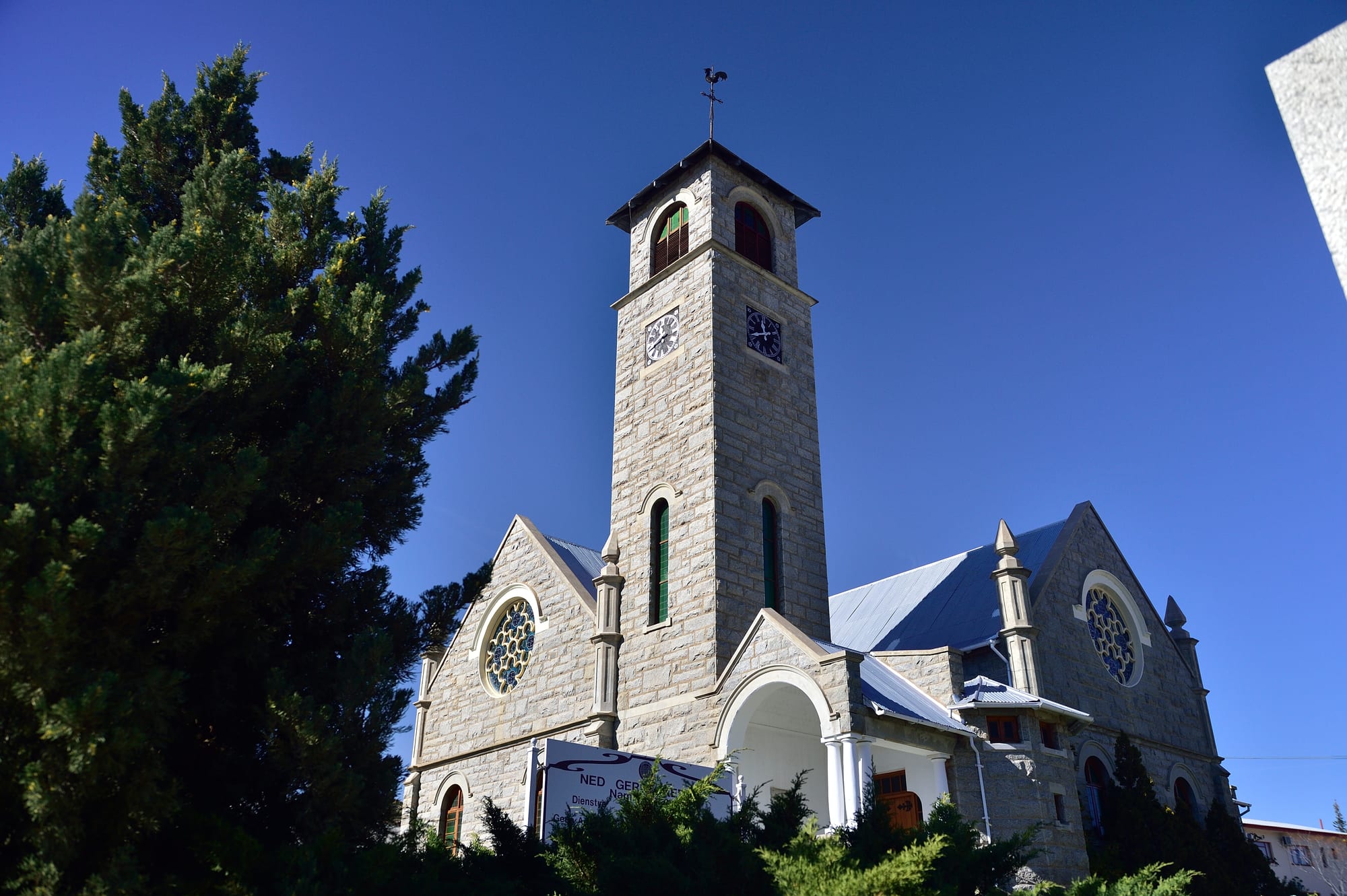
A granite church with a tall clock tower, steep roofs and rose windows against a deep blue sky, framed by dark conifers

The Northern Cape & the Kalahari, South Africa

Springbok

The stone Dutch Reformed church, the Klipkerk, in the centre of Springbok. (South African Tourism from South Africa / Wikimedia Commons · CC BY 2.0)

The largest town of Namaqualand, set in a narrow valley between the granite domes of the Klein Koperberge in the dry north-west of South Africa. It grew from the copper mining begun here in the 1850s and now serves the farms, mines and travellers of the region, filling with visitors each spring when the surrounding hills and plains turn to sheets of wildflowers.

Neighbourhoods

  • The town centre
    • First-time visitors
    • Shopping
    • Close to everything

    A small grid of streets in the hollow between the hills, with the stone church, banks, supermarkets, fuel stations and outfitters that supply the whole region. Everything a traveller needs before heading into Namaqualand is within a few blocks.

    Open in Maps
  • The Klipkoppie and the old quarter
    • History
    • Viewpoints

    The rocky knoll in the middle of town, used as a fort by Boer forces in the South African War, with the remains of stone walls on top, the Klipkerk of 1921 beside it and older houses below.

    Open in Maps
  • The hillside suburbs
    • Quiet and residential

    Houses climbing the granite slopes around the bowl, where most of the town lives, with guesthouses among them and the koppies rising straight from the back gardens. The hillside streets give the best sense of how tightly the town sits in its valley.

    Open in Maps
  • The surrounding flower country
    • Spring flowers
    • Farm stays

    Farms, nature reserves and gravel roads spreading out from the town across the granite hills and sandy plains, empty and grey for most of the year and carpeted with daisies and succulents after the winter rains.

    Open in Maps

Things to do

In the town

  • Klipkoppieviewpoint

    The small hill in the centre of town from which the streets lead off, used as a fort by Boer forces in the South African War for its view across the valley, with remains of stone walls and plantings of Namaqualand flora such as the quiver tree.

    Open in Maps
  • The town museummuseum

    The town's museum, a short walk along Monument Street, housed in the ornate old synagogue left by the Jewish community that once flourished here, while a small stone Anglican church in the town serves as the tourist office.

    Open in Maps

Flowers and nature

  • Goegap Nature Reservepark

    A semi-desert reserve about 8 km east of town, formerly the Hester Malan Nature Reserve, with a succulent and rock garden, gemsbok, klipspringer and Hartmann's mountain zebra, looping trails of 2 to 17 km, and a strong flower display in spring.

    Open in Maps

Short trips from the town

  • Okiepattraction

    A copper town about 8 km north, ranked in the 1870s as having the richest copper mine in the world, first worked by Cornish miners, and besieged by Boer forces for a month in 1902.

    Open in Maps
  • Nababeepattraction

    An old copper-mining town about 19 km north-west, founded in 1860 by the Okiep Copper Company, whose Khoekhoe name means "rhinoceros place".

    Open in Maps
  • Concordiaattraction

    A small settlement about 15 km from Springbok, a few kilometres north of Okiep, founded as a Rhenish mission station in 1852, with copper mined around it until 1983; the Boers used it as their headquarters during the siege of Okiep.

    Open in Maps
  • Namaqua National Parkpark

    A national park created to protect Namaqualand's endemic flowers, reaching the Atlantic coast, grown from the Skilpad Nature Reserve of 1993 and known above all for its spring bloom of wild flowers.

    Open in Maps
  • Kamieskroonattraction

    A small town founded in 1924 in the foothills of the Kamiesberge, below the crown-shaped koppie that gives it its name, known mainly for its abundance of wild flowers in spring.

    Open in Maps
  • Port Nollothattraction

    A seaport developed from the 1850s to ship copper from the Okiep mines and later diamonds from the Namaqua coast, now a fishing town and the main resort of Namaqualand.

    Open in Maps

Seasonal events

  • Namaqualand flower seasonbetween August and October, varying with the rains

    After the winter rains the hills, plains and reserves around the town fill with Namakwa daisies and other wild flowers, drawing visitors from across the country and filling every guesthouse.

Eat and drink

Long-standing places and food districts in Springbok. Hours, ratings and directions come from your maps app, always current.

Where to eat

  • The town centreneighborhood

    A handful of restaurants, coffee shops, bakeries and takeaways along the main streets, serving grills, burgers, pies and breakfasts to travellers, farmers and mine workers.

    Open in Maps
  • Guesthouse kitchensrestaurant

    Several guesthouses serve evening meals to their guests and sometimes to others, usually a set menu built around Namaqualand lamb, and are much of the town's dining in flower season.

    Open in Maps

Local produce

  • Farm stalls and roadside sellersmarket

    Stalls on the N7 and the roads out of town sell biltong, droëwors, dried fruit, honey, preserves and rooibos tea from the country to the south.

    Open in Maps

Experience Springbok

History

Namaqualand was the country of the Nama, Khoekhoe herders who moved stock between seasonal grazing across the granite hills and the sandveld, and San hunter-gatherers before them. Copper in the region was known to them and was being worked long before Europeans arrived; a Dutch expedition under Governor Simon van der Stel reached the Copper Mountains in 1685, and shafts sunk near present-day Okiep revealed a rich lode, but the distance from the coast and the lack of water made mining impractical for another century and a half.

The town dates from the 1850s, when commercial copper mining finally began. The farm Melkboschkuil was bought in 1852 to establish a copper mine, and the Blue Mine there is believed to mark the origins of commercial mining in South Africa. The town was laid out as Springbokfontein in 1862, a name shortened to Springbok in 1911. Okiep proved richer still, and between 1869 and 1876 a mule-drawn narrow-gauge railway was built to carry ore to the coast at Port Nolloth. The first miners at Okiep were Cornish, bringing centuries of tin-mining skill.

The South African War reached the district in 1902, when Boer commandos besieged Okiep for a month and took Concordia; the Klipkoppie in Springbok was used by the Boers as a fort. Through the 20th century the mines rose and declined, closing in stages and leaving the villages shrunken. Springbok survived as the administrative and commercial centre of Namaqualand, and tourism, drawn by the spring flowers, now joins mining, commerce and farming as a source of income.

Culture & Customs

Springbok is an Afrikaans-speaking town with deep Nama roots, and the two run together in everyday life. The local Afrikaans carries Khoekhoe words and a particular Namaqualand lilt, place names across the district are Nama, and many families trace descent from the herding communities that held this land before the mines. Nama traditions of music, story-telling and crafts, among them the reed flute, are part of the region's heritage.

The mining past shapes identity as much as farming does. Okiep and Nababeep families measure their history in shafts and shifts, and the mining past is treated as heritage. Church life is central — the stone Klipkerk of the Dutch Reformed church in the centre of town is the landmark that visitors photograph most — and mission history is strongly felt in the villages.

Then there is the flower season, which is less a festival than a transformation. For a few weeks in spring the town's population is outnumbered by visitors, guesthouses are full, farmers open gates to their lands, and locals give advice on which road has the best display that morning, since the blooms follow the rain. Outside those weeks life is quiet and slow, sport and braais fill weekends, and people are used to travellers arriving dusty from long drives and are generous with directions.

Daily Life

About 12,800 people lived in Springbok at the 2011 census, making it a small town that functions as a capital: the seat of the local municipality and the place where everyone in Namaqualand comes for a hospital, a high school, a bank, a supermarket or a government office. Employment comes from those services, from small-scale and contract mining, from farming — chiefly sheep and goats on the surrounding veld — and from tourism concentrated into the spring.

Houses climb the hillsides around the central hollow, and the town's older divisions, inherited from apartheid planning, still show in where people live. Many households have members working on mines or farms elsewhere in the province or in Cape Town, and remittances matter. The mining villages north of town, Okiep, Nababeep and Concordia, have lost population as the mines closed, and their future is a standing local concern.

The day starts early and pauses in the afternoon heat. Water is scarce and its supply is a perennial issue, as are unemployment, the long distances to specialist services, and the state of the gravel roads. Power cuts have shaped routines for years. In spring the rhythm changes completely, with traffic on the N7, full restaurants and a short, intense season of income before the quiet returns.

Food

Namaqualand lamb is the local pride: sheep grazed on succulents and veld herbs, which gives the meat a flavour that people here will discuss at length. It is grilled as chops over coals, roasted as a leg, or slow-cooked in a potjie, the three-legged iron pot set on the fire, and skaapkop, a sheep's head cooked slowly, is a traditional dish. Goat is eaten too, and game such as springbok appears as steaks and biltong.

Bread is made on the fire as often as in the oven. Roosterkoek, dough cooked on the braai grid and split with butter, apricot jam or cheese, is a staple, along with potbrood from a cast-iron pot. Mutton stews with potatoes and pumpkin, pap and samp with beans, and thick soups suit the cold winter nights. Preserves, dried fruit and honey come from the farms and the roadside stalls.

Nama and mission traditions contribute sour milk, goat's milk and the use of veld plants, and indigenous roots and herbs appear in country kitchens. Rooibos tea, grown in the mountains to the south, is the everyday drink, and strong coffee is common on farms. On the coast at Port Nolloth the food turns to the Atlantic catch of its fishing fleet.

Planning tools

Budget

Springbok is inexpensive for most of the year, with simple guesthouses, self-catering units and camping at modest prices and few places to spend heavily. Rates rise and rooms disappear in the flower season, usually between August and October. Fuel and car hire are the largest costs, since the distances between sights are long.

Daily Budget Midrange
USD 120–250 (guesthouse, restaurant meals, car hire and fuel, reserve entry)
Daily Budget Shoestring
USD 40–70 (campsite or budget guesthouse, self-catering, shared car)

Book months ahead for the flower season, and fill the tank in town before driving the gravel roads or the coast road.

Best Time to Visit

The flower season usually falls between August and October, starting at a different time each year and depending on the winter rain. Autumn and early winter are mild and quiet. Summer from December to February is very hot and dry, and the countryside is grey and bare.

Suggested Number of Days

A night or two is enough for the town and the nearest reserve. Three to five days suit the flower season or a wider loop through the mining villages, the national park and the coast, since the driving distances are long.

First Visit
1–2 days
With Surroundings
3–5 days

Transportation

A car is essential. The town centre is small and walkable, but the reserves, villages and viewpoints are spread over tens of kilometres, many of them on gravel. Minibus taxis link Springbok with the other Namaqualand towns and with Cape Town, and intercity coaches on the N7 stop here. Car hire is limited, so it is usually arranged in Cape Town.

Gravel roads are corrugated and sandy in places; reduce speed, keep to daylight, and check whether a route needs high clearance before setting out.

Airport & Station Connections

Most visitors drive the N7 from Cape Town, about 550 km and six hours south, or come the other way from the Namibian border at Vioolsdrif, roughly two hours north. Upington lies some four and a half hours east. Flying usually means landing in Cape Town or Upington and driving.

Walkability

The centre is compact and walkable, with the shops, the church and the Klipkoppie within a few minutes of each other, though the streets climb steeply on the edges of the bowl. Everything beyond the town needs a vehicle, and the summer sun makes midday walking uncomfortable.

Safety

Springbok is a quiet country town where crime is far lower than in South Africa's cities, and the centre is routine by day. The risks are mostly environmental and on the road: heat, dehydration, long empty stretches with little mobile signal, gravel surfaces, and livestock and game on unfenced roads at dusk.

Tell someone the route on remote drives, carry extra water, stay in the vehicle in the Kgalagadi except at designated sites, and drive only in daylight. Keep valuables out of sight in a parked car, and carry a spare tyre and water on gravel routes. Check current official travel advice before travelling.

Climate

A semi-desert climate with what little rain there is falling in winter, unlike most of South Africa, which is why the flowers appear in spring. Days are dry and sunny, and nights cool sharply. In the southern hemisphere summer runs from December to February and winter from June to August.

Summer
hot and dry, typically 30–35°C by day, with strong sun and cool evenings
Winter
mild days of 17–20°C with cold nights, occasional frost, and the region's rain

Local Customs

Afrikaans is the language of almost everyone, carrying Nama words and a distinctive Namaqualand accent, and English is understood in guesthouses and shops. Nama heritage is strong in the wider region and is treated with respect. Life is rural, church-centred and unhurried, dress is practical, and greetings before business are expected. Ask before photographing people or their homes.

Stay on marked tracks in the flower fields and reserves rather than walking or driving into the display, respect farm gates and private land, and tip about 10 per cent in restaurants.

Common Payment Methods

The currency is the South African rand. Cards are accepted in the supermarkets, fuel stations, restaurants and larger guesthouses in town, and there are ATMs in the centre, but the small villages, farm stalls and reserves around Springbok often want cash, so it is worth drawing money here.